


Environmental Geological Survey
To carry out the environment geological survey in circum-Bohai Sea area, Yangtze River Delta, Pearl River Delta, the west side of the Taiwan Straits, Beibu Gulf, Hainan Inland and important
economic areas to ascertain regional crustal stability, coastal erosion and sedimentation, and land subsidence. At the same time, the special investigations on the major environmental
geological problems in key seaports and cities have been carried out in order to provide geological basis for the social and economic development as well as the urban development.
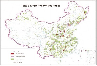
2. Environmental geological survey on the nationwide mines to promote simultaneous development of resource exploitation and environmental protection
The investigation and assessment of environmental geology for the nationwide mines, detailed investigation of environmental geological problem in the key mines have been carried out. The RS monitoring system of the nationwide mines has been built. The purpose of the investigation is to provide new means for mine’s management and execution, and to provide the technical support for management of land and mineral resources.
3. Investigation of the active faults and assessment of regional crustal stability of the national key infrastructure construction
The investigation of regional geology, crustal stability and environmental geology has been carried out to provide the basic maps data and background of environmental geology for the
national key construction projects, such as: the Dali-Ruili Railway construction project, the water diversion project from the south to the north (west line), the Qinghai-Tibet Railway construction project, the gas transport from west to east, water diversion from the Three Gorges to the Yellow River, site selection of nuclear power stations and so on. At the same time, the investigation and assessment of the engineering geological stability of the major active faults in Beijing area have also been conducted.
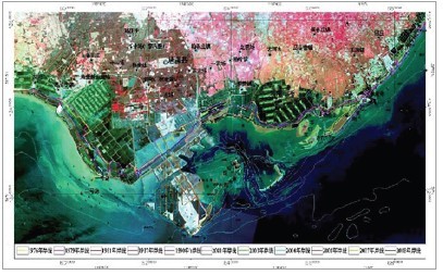
Remote sensing image of geological environment
in Caofeidian New Development Zone
Distribution map of active faults along the Da-Rui railway
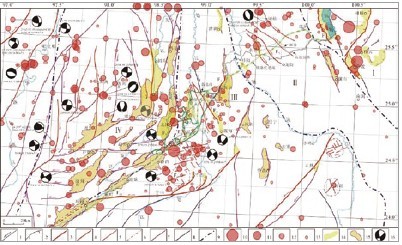
Distribution map of active faults along the Da-Rui railway