


Achievements
THE CHANGE DISCIPLINARIAN AND TENDENCY OF MAJOR IONS CONCENTRATIONS IN TYPICAL SUBTERRANEAN RIVER IN SOUTHWEST KARST AREAS, CHINA
Guo Fang1,2, Jiang Guanghui1, Yuan Daoxian1
1 College of Resources and Environmental Science,Southwest University, Chongqing 400715
2 Karst Dynamics Laboratory,
Abstract: Subterranean river is an important reservation and floating location for karst water resources in
Key words: subterranean river ,land use ,ion concentration ,auto-monitor
1 The Study Status and Significance in National and International
Groundwater in karst area is an important water resource, about 25 percent of population mostly or entirely use karst water in the global. The karst ground water is mainly distributed in southwest karst mountain areas include Guizhou, Guangxi, Yunnan, Hunan, Guangdong, Hubei, Sicuan Province and Chongqing, it covers a karst area of 7.8 million square kilometer here, and has a population of eight hundred million. It has been found out primary that only in Guangxi there are 3066 subterranean rivers with an annual natural resource of karst groundwater of 180.8 thousand million cube meter. There are 435 subterranean rivers and 736 karst springs having
A lot of studies for karst water quality have been done in
The main population is rural population in South karst area, groundwater quality is well as a whole here, most of them belong to I, II grade, but when they are compared with those in twenty years ago, the major ions concentration of ground water have observably increased, showing that ground water quality has a tendency of deterioration. Agriculture activity is a main factor responsible for ground water deterioration. Thus in order to find out the change disciplinarian of ions concentration, we need to take a long-term monitor for subterranean rivers, according to this we can have a scientific evaluation of ground water variation tendency. We had carried out the hydrogeological general investigation in late
2Description of Sampled Subterranean River System
Guancun subterranean river lies in Daliang, Rong’an county, with a distance of
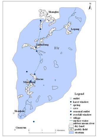
Fig.1 Hydrogeological map of Guancun subterranean river drainage basin
3 Materials and Methods
Guancun subterranean river is selected for the study area. We use multi-auto memorized instrument(CDTP300) produced by Greenspan Co. Australia to auto-monitor water level, water temperature, pH, electrical conductivity, precipitation at the exit(15min/once) from Nov.2004. From Jun 2004, with WTW and portable Ca2+ and HCO3- testing box we test pH, EC, water temperature, Ca2+、HCO3- in the scene once a month, the concentration of K+,Na+,Ca2+,Mg2+,Cl-,SO42-,NO3-,NO2-,NH4+ were analyzed in the laboratory. After rainstorm in fertilization season, we increase sampling density when the subterranean river swelling. Water chemistry data of 1978 and 1980 were colleted; land use and human activity in the drainage area were surveyed.
4 Results and Discussion
The water type of Guancun is Ca-HCO3, in this Ca2+、HCO3- are the dominant component, Mg2+、Na+、K+ 、Cl-、SO42- 、NO3- are secondly, the other ions and microelement are very few. Ca2+、HCO3-、Mg2+ are mostly derived from D3r carbonate and dolomite, so the contents of them have a compact correlation with karst process. All factors affected karst dynamics system would have an impact on the concentration of three ions. The concentration of K+、Na+ in the rock are less than those in water and soil, while they are equally in soil and water, showing that K+、Na+ are mostly derived from soil, some studies also show that Cl-,SO42- ,NO3- mostly come from soil.
We take a water sample as behave of the month water quality from Jun 2004 to Jul. 2005. We observe several floods process and take water samples after an interval of 30min in May and Jul. 2005. The comparative results are showed in the table below. Although only the concentration of Ca2+ and Cl- in May 1980 and NO3- in April 1978 are less than those variational range now, most of the concentrations of ions sampled in 1978 and 1980 are lower than variational range of 2004 and 2005, but the average of K+,Na+,Mg2+,Cl-,SO42-,NO3- are higher than those of 1978 and 1980, we have do more study to answer these questions.
Table.1 Comparison of ion concentrations in two periods
Sampling Date |
| K+ | Na+ | Ca2+ | Mg2+ | Cl- | SO42- | HCO3- | NO3- |
2004.6- 2005.7 | Min. Max. Mean | 0.14 0.96 0.55 | 0.36 1.00 0.68 | 71.14 85.00 78.07 | 4.81 11.83 8.32 | 2.79 9.30 6.05 | 0.10 18.38 9.24 | 173.90 289.04 231.47 | 0.18 15.40 7.79 |
1978.4 |
| 0.30 | 0.65 | 78.16 | 4.86 | 4.96 | 5.00 | 256.28 | 0.05 |
1980.5 |
| 0.30 | 0.60 | 69.14 | 6.08 | 0.72 | 2.00 | 231.88 | 1.20 |
4.1 Stabilization and variety of water chemistry
The results of auto-monitored show that precipitation is a major factor induced the variety of ions concentration. In dry season(Sept.1004-Fre.2005), with small rainfall, water level keeping stability, water in the conduit and gravity water in soil having released completely, drainage water from the export of subterranean river is the groundwater storage in karst fracture, so the ions concentration is relative with water-rock reaction at this time. The fractures in carbonate are under half opened state, in this condition matter and energy communicating with atmosphere little; the exterior conditions of karst dynamics system keep stability, thus pH, EC(Electric Conductivity), water temperature of groundwater retain steady state(Fig.2).
Due to continually rainfall in rainy season(June-August 2004, March-July 2005), water level and flow are in a state of continually variety, which results in the other ion concentrations changed constantly too. The total rainfall is
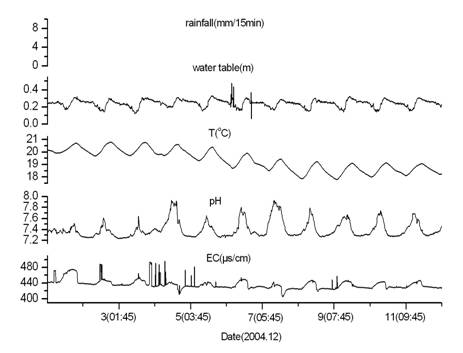
Fig.2 Dynamics variation of hydrochemical in exit of subterranean river in dry season
4.2 Ion concentrations in flood process
Precipitation supply to subterranean river, following that ion concentration will change. There is osculation relationship between ions variety characteristic and the sources of them. The ions which derived from soil will enter into subterranean river while rains, they will not react with other ions, due to the quantity released from base rock is small, they have a possibly of adsorbing or exchanging with clay in subterranean river motherboard. The relationship between ion concentration and recharge quantity of new coming subterranean river and the original of them determines the variety of ion concentration. The rainfall in late May 2005 didn’t result in descend of K+ concentrations, even it rains frequently, with water level fluctuating acutely, K+ concentrations don’t have a continuous decrease, instead they will ascend sometime. High water level doesn’t correspond with low concentrations(Fig.4). Continuance rainfall since Mid-June results in K+ concentrations drop to the rainwater’s concentration. Following the decline of water level K+ concentrations decrease, finally they return to rise(Fig.5). The lower concentration of K+ is 0.14mg/l, while K+ concentrations of rainwater in June is 0.19mg/l, indicating that K+ concentration decrease continually in soil due to rainfall leaching, till to the lowest value in a hydro-year. It also shows K+ is an activity cation, it will not resort in soil for a long time. Na+ is sensitive to rain, the rainfall beginning at May didn’t result in observably change of Na+, but rainfall from late May to June make Na+ concentration decreased rapidly. After decline they will decrease immediately, it is normal to Ca2+ and HCO3- those derived from rock but Na+ won’t do that. The possibly reason may be water from fracture has sufficiency contact with soil which result in high concentration of Na+, this water lag to water recharge to subterranean via dolines, after it entering into river Na+ concentration will rise.
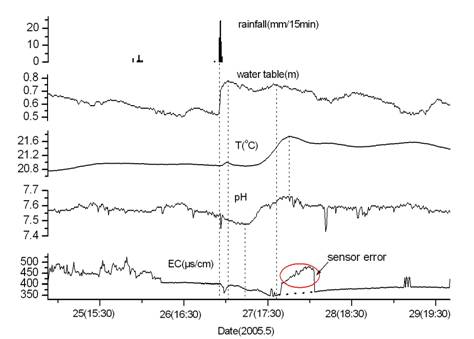
Fig.3 Dynamics variation of hydrochemical in exit of subterranean river in rainy season
Ca2+ is derived from rock, with the concentration variety discipline of decline after water level rising before long, and then it will ascend. These phenomenon appear repeated in two rainstorms observation, the reason is low concentration of water recharge to subterranean river when rains, which results in Ca2+ concentration decrease, and then Ca2+ increase due to CaCO3 dissolution in karst process. The variety of Mg2+ is similar with Ca2+, because both of them come from karst process, but the concentration of Mg2+ is lower than that of Ca2+, so Mg2+ derived from soil is more important to the variety of it’s concentration. Mg2+ rise gradually in June, while Ca2+ will decrease during increase process, the different reason between them may be this. The variety of Cl- in May is instability, but rainstorm observation in June it became steady(Fig.7,8). From unsteadiness to steady showing that they affected by anthropogenic activities. Because late April is fertilization and transplant rice seedlings season. In paddy field collects large quantity of fertilizer, when rains fertilizer transfer to subterranean river, which makes Cl- concentration fluctuated. Cl- concentrations reach normal level in cropland in June, so the concentrations don’t fluctuate any longer.
Fig.4 Variation of cation concentrations in floodwater in May, 2005
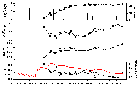
Fig.5 Variation of cation concentrations in floodwater in June-July, 2005
From May to June Cl- in subterranean river system decrease due to rainfall leaching, representing in notable decrease. Though it suffers from dilution from rainfall replenishment, Cl- keeps continuance stabilization in flood events. The likely reason is Cl- concentration in underground is equaled to that in surface space, when they mix together, they will not affect the total concentration, or maybe Cl- in underground system have a strong balance ability(they can reach balance via adsorbing and exchanging). More studies should be done for these.
SO42- concentrations greatly increase after fertilization shows fertilizer in cropland also has a great impact on SO42-. When rains, water level swells in a short time inducing SO42- decrease, but they rise to a high level soon. We consider it may be enriched highly in surface, which have some similar with Cl- in late May, while the difference is SO42- keep this phenomenon until June.
The variety discipline of HCO3- is similar with Ca2+, because both of them come from rock, they have an osculation relation with karst process.
NO3- has a tendency of degression from May to June, this is because of two big rainfalls. NO3- appears an up fluctuated in flood process in late May, but they disappear in late June, instead they keep steady, this is very similar with Cl-, because both of them greatly affect by fertilization in late April. We can’t draw out why NO3- doesn’t have a low value, but this doesn’t affect the total concentration of NO3-.

Fig.6 The relationship between anion concentrations variety and water table in May, 2005
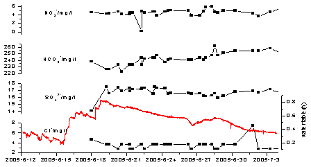
Fig.7 The relationship between anion concentrations variety and water table in Jun-Jul, 2005
The main reasons for ion concentrations variety are rainfall and human activity. In dry season(from Sept.-Fre.), rainfall account for 11% of the total in a year. Rainfall centralized on May, June and July gradually increase from March and from August it begin small. Agriculture activity is connected with the climate. In the study area, Farmer often fertilize dry land in February to plant sugar cane, harvesting in November. For cropland fertilization quantity is 373
4.3 Ion concentrations vary monthly
Ion concentration in subterranean river is affected by climate change in a year and human activities discipline, in which rainfall is the most important climate factor. Rainfall change and human activities are contributed to the discipline change of ion concentrations. The high value of NO3- is in February to May in a year, the concentrations in other months are similarity; they are belonged to low value. One reason for high value is NO3-enriched in surface are leached into subterranean river when the rain begin; the other reason is a large quantity of fertilizer contain nitrogen are used in this period. SO42- appear high value in May to July too, we have educed the reason before, tit is affected by fertilization too. Cl- concentrations don’t vary greatly in a year, only in February to May, 2005 they present a little decrease, but they truly affected by rainfall and human activities, we can make sure by high density observation in rainfall process. The influence don’t present in the monthly variety curve, indicating the influence only keep a short time. All of HCO3-,Mg2+,Ca2+,Na+,K+concentrations have the discipline of high value in dry seasons and low value in wet seasons, they are closely connect with rainfall. Because HCO3-,Mg2+,Ca2+ come from dissolution of carbonate, the influence of human activities keep short time, so while in low density sampling they reflect the phenomenon of dilution by rainfall and enrich in dry seasons. Cl-,SO42-,NO3- in anions are correlation with human activities closely, the total proportions variety of them in anions are opposition with those of K+ and Na+, they representing low in winter and high in summer. Values in rainy seasons are higher than those in dry seasons, which reveals the function of human activites.
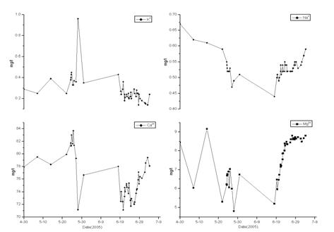
Fig.8 Cation concentrations variety affected by rainfall after fertilization
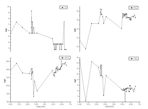
Fig.9 Anion concentrations variety affected by rainfall after fertilization
4.4 The trend of ion concentrations variety in the past two decades
Because only one or two groundwater samples analyzed data were done in the last hydrogeological survey of the whole country, it is difficult in comparing with them. We have compared the analyzed data with the pre-data, and find some of them decrease. The low value of NO3- is in the month except for February-May, the average value is 4mg/l, the high value is ranged in 9-16mg/l, individual one is less than 1mg/l, value in 1978 and 1980 are greatly lower than the lowest value, which shows NO3- decrease certainly. Low value of SO42- doesn’t have any discipline, for example, the lowest value was in August and Sept. 2004, but they didn’t appear that in August 2005. Low value is smaller than 5mg/l, middle value is about 9mg/l, high value is about 15-19mg/l in May-July due to fertilize, the appearance of low value doesn’t have some rule, so we can’t say SO42- has decreased generally. Low value of Cl- appears after rainfall in Summer due to dilution of rainfall, low value is ranged in 2-4mg/l. High value is 7-10mg/l in February to June, the normal value is about 5mg/l. Although the value of 1978 is in the normal range, value of 1980 is greatly lower than lowest value, showing that Cl- increased a little. Low values of K+ appear in the flood process of Spring and Summer, they are less than 0.3mg/l, the normal is about 0.4mg/l, high value is seldom. Results in 1978 and 1980 are between the lowest and the highest value, which shows that K+ has no distinctively change. High value of Na+ appear in winter, which is about 1mg/l, the normal value is 0.6mg/l, low value is less than 0.55mg/l, they have no distinctly change comparison with those of them before. High value of Mg2+ is in winter, which is about 9-11mg/l, in the initial stages of flood even it has low values transitorily, which is about 6mg/l. The two results of prophase are in the range of low value, so Mg2+ has a possibility of increase. Ca2+ and HCO3- don’t have a possibility tendency of increase.
Fig.10 Relationship between eight ions concentration variety in four periods and rainfall
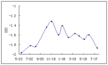
Fig.11 Variety of calcite saturation index in 2004-2005
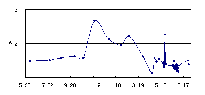
Fig.12 Monthly variety trend of K+ and Na+ proportion in cations
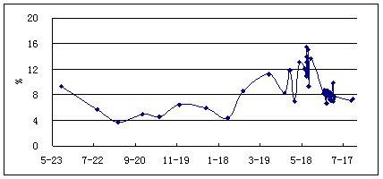
Fig.13 Monthly variety trend of SO42-, Cl- and NO3- proportion in anions
5 Conclusion
Long-term auto-monitor for subterranean river, measuring the index which sensitive to environmental change such as pH, EC, water tempreture, HCO3- and Ca2+ in the scene, observation monthly and in flood process, especially in fertilization seasons increasing observation density are approaches of exploring water quality variety discipline of subterranean river in South karst areas. NO3-,SO42-,Cl-,K+ are the major objects of observation.
Observation and Sampling for Guancun subterranean river for about a year shows, except for rainfall, agriculture activities are main factors having greatly impact on groundwater quality. K+,NO3-,SO42-,Cl- are affected by fertilization distinctively.
NO3- increase in recent twenty years distinctly; the variety discipline of SO42- is very complex, it need observation for longer time; Cl- increase a little; K+ and Na+ don’t have a obvious change; Mg2+ has a possibility of increase; HCO3- and Ca2+ don’t change.
References:
[1] Groundwater in China, Remove Your Mask-Analysis of 《 Groundwater resources and environment survey》report, China land and Resources News,
[2] Yao Changhong, Yang Guifang, Jiang Zhongcheng et al., Human Activities and Their Effects on Geological Environment in Shuicheng Basin, Guizhou Province[J], Urban Environment and Urban Ecology, 2002,Vol.15,No.5:1-3
[3] Jia Yanan, Yuan Daoxian. The impact of landuse change on karst water in Shuicheng basin of Guizhou Province[J], ACTA GEOGRAPHICA SINICA, 2003,Vol.58, No.6:831-838
[4] Jia Yanan, Diao Chengtai, Yuan Daoxian. The influence of land use on karst water quality of buried karst region-A case of Conglin karst ridge-trough at
[5] Zhang Cheng, Yuan Daoxian. Hydrochemical Variation of Typical Karst Subterranean Stream Basin and Its Relationship with Landuse Change-A case study of Subterranean Stream Basin, Puding County, Guizhou Province[J]. Journal of Soil and Water Conservation, 2004,Vol.18, No.5:134-137
[6] Jiang Yongjun, Yuan Daoxian, Zhang Gui et al., Effects of landuse change on groundwater quality in karst watershed-A case study in Xiaojiang watershed in
[7] N.Gülbahar,H.Elhatip.2005.Estimation of environmental impacts on the water quality of the Tahtalidam watershed in
[8] Y.Abu Maila,I.EI-Nahal,M.R.Al-Agha.2004.Seasonal variations and mechanisms of groundwater nitrate pollution in the Gaza Strip[J],Environ Geol 47(1):84-90
[9] B.G.Katz. 2004.Sources of nitrate contamination and age of water in large karstic springs of
[10] Amox Frumkin, 1999. Interaction between karst, water and agriculture over the climatic gradient of
[11] Juan Reynerio Fagundo Castillo, Patricia González Hernandez, 1999. Agricultural use and water quality at Karstic Cuban Western Plain[J], International Journal of Speleology, Vol.28(1/4):175-185
[12] Guo Fang,