Achievements
ESTIMATION OF GROUNDWATER RECHARGE BY 1D UNSATURATED WATER MODELING——A CASE OF STUDY IN LUAN CITY, HEBEI PROVINCE
Xiaohui Lu, Menggui Jin
(School of Environmental Studies, the China University
of Geosciences, Wuhan Hubei,
430074,
Abstract: Accurate estimation of groundwater
recharge is essential for the reasonable management of aquifers. Unsaturated
zone is the path of infiltration recharge, and groundwater recharge can be
determinate by unsaturated water simulation. Hydrus-1D software is used to
determine the groundwater recharge in Luan city,
Key words: Numerical simulation; Recharge; Unsaturated zone; Soil water
1 Introduction
Estimation of the amount of infiltration recharge to a reasonable degree of accuracy is essential for the proper management of aquifers [1]. Previous research on the recharge to groundwater was concentrated mainly in two areas: the study of infiltration mechanism and the recharge process using experiment, analytical solutions and numerical simulation (Allison etal. 1994;Nimmo, et al., 1994). Human activities related to water resources in Hebei Plain have triggered many conflicts both presently and historically. Periods of groundwater level descending in the North China plain have emphasized the need for reliable estimates of groundwater recharge. Application of numeric simulation for Hebei Plain can afford academic foundation to reasonable groundwater utilization.
In this paper, experiments and numerical simulations were used to
determine the recharge to groundwater in Luan city,
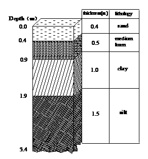
(Fig1.histogram of lithological
characters of Luan city,

Fig.1 histogram of lithogic characters of Luan city
2. Numerical Modeling
Hydrus-1D
software is used to determine the groundwater recharge in Luan city,
The simulation process of soil moisture movement can be described in Fig.2.
2.1 Conceptual model
Top boundary is dealt as variant flow condition and the flux is determined by the atmosphere data. The bottom condition is changeable pressure head boundary. Unsaturated soil water in the center of experimental field moves in vertical, the 1D saturated - unsaturated model is used to simulate the water flow in the soil profile.
2.2 Mathematic model
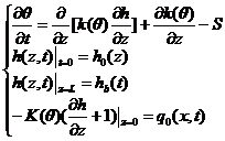
The mathematical model is as follows,
 (2-1)
(2-1)
here,
![]() is soil volumetric water
moisture[-]; h is pressure head[L]; z is vertical coordinate[L], equaling to
zero on the ground, upwards meaning positive; t is the time[T]; K(
is soil volumetric water
moisture[-]; h is pressure head[L]; z is vertical coordinate[L], equaling to
zero on the ground, upwards meaning positive; t is the time[T]; K(![]() ) is unsaturated conductivity
coefficient[LT-1]; S is sink, meaning root water uptake distribution
here (d-1); q0(t) is
water flux at top[LT-1]; hb(t)is the
bottom pressure[L]; L is model depth[L].
) is unsaturated conductivity
coefficient[LT-1]; S is sink, meaning root water uptake distribution
here (d-1); q0(t) is
water flux at top[LT-1]; hb(t)is the
bottom pressure[L]; L is model depth[L].

2.3 Numerical simulation
Equation (1-1) is a nonlinear partial differential equation, which is very difficult solved by analytic method, and usually be solved by numerical simulation in field. We use linear insert method and Hydrus-1D software developed by USSL (United States Soil Laboratory) to simulate.
2.3.1 Discritization
The depth of simulation is 33m below the ground, 3.4m below the ground is divided into 20 units, and 3.4m to 33m below the ground is divided into 75 units, therefore, the model is divided into 95 units in total.
Simulation time is from Jan 1, 2003 to Sep 7,2003 and 250 days in total.
2.3.2 Boundary conditions
Top of the model is open boundary, which receives precipitation, irrigation and evaporation and crop root uptake. The data can be directly endowed with practical observed precipitation and evaporation data, and crop root update module in Hydrus-1D.
Bottom is the known pressure boundary, and can be directly endowed with pressure, using observation data in Hydrus-1D software.
2.3.3 Parameterisation
2.3.3.1 Saturated conductivities mensuration
In the indoor experiments, the vertical saturated conductivities of original soil, which obtained from 0-20cm, 35-50cm, 280-310cm at No.185 experimental site of Luan city through the variable head experiments, are 42.04cm/d, 28.56cm/d, and 41.38cm/d respectively.
2.3.3.2Water soil water characteristic curve observation and related parameters
The water content characteristic curve of regional soil are expressed by the observed soil moisture and negative pressure, which obtained from 4-10cm, 10-16cm, 18.5-24.5cm, 36.5-42.5cm, 285-291cm at No.185 experimental site of Luan City through the indoor experiments
van Genuchten formula:
 (2-2)
(2-2)
where ![]() is saturated soil moisture;
is saturated soil moisture;![]() is languish soil
moisture;h
is negative pressure head;
is languish soil
moisture;h
is negative pressure head;![]() is soil volume content;
is soil volume content;![]() 、m、n
is pending coefficient,m=1-1/n,determined
by the characters of soil.
、m、n
is pending coefficient,m=1-1/n,determined
by the characters of soil.
Parameters are obtained by RETC simulation solved numerically using van Genuchten formula.
Table1 parameters through RETC simulation
|
No. |
Sampling depth(cm) |
|
|
|
|
|
2 |
4-10 |
0.12 |
0.37 |
0.10 |
1.32 |
|
3 |
18.5-24.5 |
0.19 |
0.34 |
0.005 |
1.81 |
|
4 |
10-16 |
0.08 |
0.31 |
0.03 |
1.24 |
|
5 |
36.5-42.5 |
0.08 |
0.40 |
0.029 |
1.12 |
|
6 |
285-291 |
0.08 |
0.46 |
0.007 |
1.73 |
2.3.3.3 Evapotransporation
There are some methods of calculating crop potential evapotranspiration, such as aerodynamics method, energy balance method and integration method [3](Penman formula method) and experienced formula method.
2.3.4 Parameter calibration
Based on observed soil moisture, using Trial-and-error Procedure to identify unsaturated hydraulic parameters.
According to the soil water characteristic curve equation (2), soil moisture change mainly effected by n because n is the index of ah and n is changing in a wide range between 0.02 and 0.2,which is sensitive to moisture change. Identifying n first during identifying parameters process.
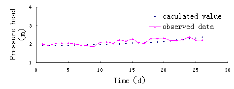
The parameters are determined by Hydrus-1D and field data in the duration from 1/1/2003 to 1/30/2003 because there are no crop and evaporation after winter irrigation and water flows down only. The model with the parameters derived from soil characteristic curve run, and the calculated moisture curve is compared with the field data curve (such as fig.3), if the error between calculated moisture and field data is larger than the standard value expected, n is changed and the model runs again. The process is repeated until the error is less than the upper limit expected, and the best parameter obtained at last. The parameters in the last model is as follows,
Table 2 soil water conductive parameters through model identification
|
depth(cm) |
lithology |
|
|
|
|
|
|
0-40 |
Loam |
0.086 |
0.32 |
0.0134 |
1.574 |
33.49 |
|
40-80 |
Clay Loam |
0.089 |
0.361 |
0.0315 |
1.179 |
22.33 |
|
80-120 |
Loam |
0.091 |
0.365 |
0.0329 |
1.150 |
34.66 |
|
120-260 |
Clay Loam |
0.099 |
0.376 |
0.0151 |
1.147 |
23.33 |
|
260-340 |
Clay |
0.103 |
0.418 |
0.0086 |
1.153 |
12.96 |

Fig.3 comparing calculated and observed pressure head
2.3.5 Error analysis
Pressure head and practical observed data is described in Fig4. Fig4 is practical observed pressure on soil profile and model simulation comparing. From Fig-4, there are some error between simulated soil moisture and practical observed data.

2.4 Results
Irrigation and rainfall is divided into four parts: evapotranspiration, infiltration, soil storage. Precipitation is 385.91mm,according to “Main crop Water requirement and imgation of China”[5] show that winter crop average irrigation is 165 mm, according to “New concept of water saving study and application of real water saving”[6]. Two supply items at the above boundary of model: irrigation and rainfall, irrigation supply is 165mm, rainfall supply is 385.91mm;drainage can be classified by two items: evaporation and distillation: evaporation is 48.9mm,distillation is 253.9mm.the supply of the bottom boundary of model is 372.55mm.the above soil seep into deep soil is 379.21mm.The soil storage is 241.45mm.
3 Conclusions
(1) In the indoor experiments, the vertical saturated conductivities of original soil, which obtained from 0-20cm, 35-50cm, 280-310cm at No.185 experimental site of Luan city through the variable head experiments, are 42.04cm/d, 28.56cm/d, and 41.38cm/d respectively.
(2) Evaporation and distillation: evaporation is 48.9mm;distillation is 253.9mm.the supply of the bottom boundary of model is 372.55mm.the above soil seep into deep soil is 379.21mm.The soil storage is 241.45mm.
Acknowledgements:
This study has been carried out within the framework of the “National geological investigation program” of CGS, grant no. 200310400035-1.Thanks to all members of the project group for the fruitful collaboration.
Reference:
[1] J.Simunek, T.Vogel and M.Th.van Genuchten.. Code for Simulating
Water Flow and Solute Transport in One-Dimensional Variably Saturated Media.
[2]Fred Lund DG, Anqingxing. Equation for the soil-water characteristic curve. Can.Geotech J, 1994,31:521~532
[3]
[4]Holmstrom L. Using additive noise in back-propagation training. IEEE. Trans Neural Network, 1992,3(1): 34~39
[5]Yangjun. Main crop water requirement and
irrigation of
[6]Shenzhenrong. New concept of water saving study and application of real water saving (1): 120~123
[7] Allison G B. Vadose zone techniques for estimating groundwater recharge in arid and semiarid regions. Soil Science Journal, 1994, 58(1): 6~14


