Ye Chao1, Shao Jingli2, Xie Zhenhua1,
Chen Zhihong1, Wang Xinjuan1,2
1 Beijing Institute of Hydrogeological &
Geological Engineering, Beijing,
100037;
2 China University of Geosciences, Beijing,
100083
Abstract: The characteristics of groundwater resource and its environment
under the condition of long-time exploitation are focused on in this paper, and
the strategies for reasonable development of groundwater are brought forward.
Above all, groundwater evaluation is made based on analysis of water balance.
The average groundwater recharge is 35.98´108m3/a and the safe yield is
26.33´108m3/a for multi-year.
During the latest 30 years, the groundwater exploitation quantity is about
26-28´108m3/a, which is at the
state of over-exploitation and has resulted in the geological environmental
problems, such as sustaining groundwater drawdown, land subsidence, water
quality deterioration and so on. Now the area of groundwater depression-cone is
over 1000km2,
and the area with more than 200mm’s
accumulative land subsidence is up to 350km2.
Aiming at the current situation of water resource shortage in Beijing and based
on analysis of water supply and demand, strategies for groundwater reasonable
development and assurance of municipal water supply security before and after
water from South-North Water Diversion coming into Beijing are presented, such
as supplying groundwater according to its quality, groundwater-surface water
conjunctive use and emergent well field’s exploitation and recharge and so on.
Key words: groundwater resource, safe yield, geological environment, emergent
well field, groundwater recharge
1 Introduction
Beijing is
the capital of P.R. China and locates in the north of Huabei Plain, with a
total area of 16410.54km2,
of which there are mountain area 9882.54km2 and plain area 6528km2.
It belongs to the typical warm temperate zone with a semi-humid and continental
monsoon climate. The average precipitation for multi-year is 609.9mm (figure 1). Its water system belongs
to Haihe river basin, and is mainly made up of YongdingRiver, Chaobai River, Daqing River, Beiyun River and Jiyun River,
which flow from northwest to southeast on the whole. Groundwater plays an
important role in water supply of Beijing,
and occupies about 2/3 of the total water supply quantity. With the extending
of city scale and development of economy, demands of water resource keep
increasing. Continuous over-exploitation during the latest 40 years has caused
the serious deficit of groundwater in the plain area of Beijing,
and resulted in some geological environmental problems at the same time, such
as land subsidence and groundwater quality deterioration. Although the
South-North Water Diversion Engineering can resolve the water shortage problems
at a certain extent, but as the main source of water supply, groundwater still
has a vital effect on assurance of water supply security in Beijing.
So it is necessary to know the current situation of groundwater resource and
its environment problems in Beijing,
then present the strategies for groundwater reasonable exploitation and
utilization before and after the South-North Water Diversion Engineering
implemented.
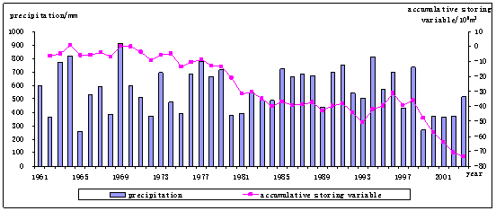
Figure 1 precipitation and
the accumulative storing variable of groundwater in Beijing
Beijing is
the region that started hydrogeological work very early and has high study
degree in this field in our country. In 1944, in order to build the well field
in the northeast suburb, Japanese
North China Development Company investigated
groundwater in urban area of Beijing and the area around it, and submitted the
report of Groundwater in
Beijing and Its Surrounding Area [1].
A lot of hydrogeological work has been done after 1949. In the 1950s, the
regional hydrogeological survey was focused on, and the municipal water supply
prospect was also developed at the same time. For example, Group 901 of the
Geology Ministry started the hydrogeological and geological engineering
investigation in the suburbs of Beijing in 1955 [2], and Beijing Institute
of Hydrogeological and Geological Engineering did the municipal water supply
prospect at the scale of 1: 50,000
in 1958, and
brought forward the Groundwater
Safe Yield in the suburbs for
the first time[3]. In the 1960s and 1970s, the municipal and field
water supply prospect was focused on, and the groundwater safe yield in the
investigated area was evaluated[4-6]. Investigations and experiments
of groundwater artificial recharge were also primarily studied[7-9].
In the 1980s and 1990s, with the increasing of water
demand in Beijing and
the occurrence of a series of environment problems due to serious
over-exploitation, besides water supply prospect, quite a lot of work has been
done, like assessment of groundwater resource in Beijing[10-11],
studies and investigations of groundwater recharge[12-14],
environmental hydrogeological investigation[15], as well as
monitoring and study on land subsidence [16-17].
Coming into the 21st century, Beijingencountered
7 dry years continuously which is infrequent, and the government began to pay
much attention to the capital’s groundwater environment. So the work such as
argumentation and water supply engineering of emergent well fields[18-19],
groundwater-surface water conjunctive use and investigation of organic
pollution to groundwater[20], and the groundwater environmental
impact assessment after the South-North Water Diversion Engineering implemented[21] has been started. Moreover, since
1956, Beijing has gradually built and perfected
groundwater monitoring work[22], and established the experimental
station of groundwater balance in Liaogongzhuang[23]. Since 1966 Beijing has done the large-scale surveying and
mapping work on land subsidence for 3 times, and set up the Land Subsidence Monitoring Center in 2004. The above work has basically
made clear the hydrogeological conditions and characteristics of groundwater
distribution. It not only has provided the primary guarantee for sustainable
development of social economy in Beijing,
but also presents reliable basis for further reasonable development of
groundwater as well as management and improvement of its environment.
2 Groundwater-forming
Condition
Bedrock mountain area distributes in the northwest of Beijing,
in which Carbonate outcrops cover an area of 2900km2.
Karstic fissure water exists in the Ordovician and Cambrian limestones and in
the Middle-Upper Proterozoic dolomites, which are mainly distributed in seven
regions such as Changgou-Zhoukoudian in Fangshan, Lujiatan-Yuquanshan in West Mountain and the 20-mile Long Mountain in Shunyi etc. It is mainly recharged
by precipitation and infiltration of surface water, and flows to the lower
places along the landform. Some of it discharges into rivers. Some flows to the
deeper area and becomes the recharge source of buried Karstic aquifers. And
part of it discharges into the Quaternary pore water. Bedrock mountain area
except Carbonate outcrops mainly contains bedrock fissure water. Such area has
little groundwater recharge and poor water-bearing.
The plain area of Beijing (except Yanqing Basin)
is mainly made up of the alluvial-pluvial fans formed by Yongding River, Wenyu River, Chaobai River, Jiyun River and Juma River.
Its Quaternary pore water mostly exists in the sand and gravel aquifers formed
by river’s alluvial and pluvial effects. It is the monolayer phreatic aquifer
in the upper part of the alluvial-pluvial fan, with the litholory of monolayer
sand and gravel. The aquifer has good water-bearing conditions, and its water
discharge of specific well is generally more than 5000m3/d.
In the middle and upper parts of all the alluvial-pluvial fans and the area
around the groundwater overflow zone, the aquifers gradually become multi-layer
structures, and they are the intensive exploitation regions. Especially in the
middle and upper parts of the alluvial-pluvial fans (UMPAF) in Yongding River andChaobai River,
the aquifers are coarse-grained and thick. They have huge storing space for
groundwater and good conditions for recharge. So the specific well rate usually
can reach 3000-5000m3/d.
In the alluvial-pluvial plain area of urban and southeastern Beijing,
the aquifers with multi-layer structure are mainly consisted of medium-coarse
sand, fine sand and silty sand. The lower confined aquifers are the main
exploitation layers. And the specific well rate is usually 500-1500m3/d.
Groundwater in the plain area is mainly recharged by
precipitation, infiltration of river and irrigation and lateral inflow from
mountainous area, in which precipitation is the primary recharge source. Under
natural conditions, groundwater is mainly consumed by evaporation and discharge
to river. But due to large exploitation at present, the artificial pumping has
become the main discharge way of groundwater.
The flow direction of the Quaternary pore water in the plain area
changes with the landform. It flows from mountain to plain and from northwest
to southeast. With the long-time intensive exploitation of groundwater, the
regional depression-cones have occurred in the area with large exploitation
quantity, and groundwater flow field also has changed a lot.
3 Groundwater Exploitation and Utilization
Beijing has
a long history of water resource exploitation and utilization. According to the
statistics [1], in the
year of Guangxu 11
in Qing Dynasty
(1855), there were 1245 artificial wells in and around Beijing.
To 1949, there were 123 pumping wells. But the annual exploitation quantity of
groundwater by pumping wells was only 803´104m3. With the growing of
population and development of economy after liberation, the exploitation
quantity of groundwater increased quickly and greatly. It achieved the maximum
quantity with the amount of about 28´108m3/a till 1980s. After
then, by the measures of water saving and industry structure’s adjustment and
so on, the groundwater exploitation quantity maintains 26-27´108m3/a despite of continuous
extending of city scale (figure 2).
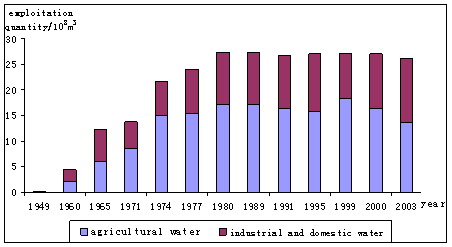
Figure 2 Changes of groundwater exploitation
quantity in Beijing in past years
Groundwater exploitation is mainly in the plain area of Beijing.
In 2000, for example, the total exploitation in the whole city was 27.08´108 m3/a
and the amount in the plain area was 25.51 ´108 m3/a,
in which the exploitation quantity in Yanqing Basin was 0.70´108m3/a. Analyzing from water
consuming structure[24], the current groundwater exploitation
quantity for agriculture is about 16´108m3/a, which occupies 61.8%
of the total amount. And the exploitation quantities for industry and living
take 15.47% and 22.6% respectively. It is known from statistics in terms of
exploitation patterns that, the pumping rate of the eight centralized well
fields in Beijing is 3.21´108m3/a (figure 3), and the
exploitation of the self-provided wells in the suburbs of Beijing is 2.67´108m3/a. From the
exploitation layer point of view, most centralized well fields locate at UMPAF
in Yongding River and Chaobai River,
and pump the phreatic and shallow confined water. The Eighth Water Plant near
Chaobai River, which has large pumping rate, exploits 1.64 ´108m3 groundwater
annually, and the annual
exploitation quantity of the Third Water Plant located at UMPAF in Yongding River is 0.88´108m3. Their sum take about
55% of the total pumping rate of all the centralized well fields. As a whole,
water in the shallow layers is mainly exploited (including the phreatic and
shallow confined water, generally referring to the aquifers within the depth of 150m),
and the exploitation quantity of deep layers beyond the depth of 150m is relatively less. The deep wells are
mostly distributed in the alluvial plain area of southeastern Beijing.
4 Groundwater
Resource Evaluation
4.1 Recharge Resource
Groundwater resource in Beijing has been evaluated for several times
since 1960s. The latest one divided the area into the plain area and the
mountainous area, and employed water balance and dynamic balance to estimate
the recharge rsource[20]. The annual mean (1980-2000) of groundwater
recharge in Beijing is 35.98 ´108m3/a, among which 27.68 ´108m3/a is in the plain area,
15.17 ´108m3/a in the mountainous
area and the overlap is 6.85 ´108m3/a. Table 1 shows the
annual mean of individual source of groundwater recharge in Beijing. It can be
seen that the recharge from the precipitation infiltration as the most
important source is 27.2´108m3/a, taking 75.6% in the
total amount. The plain area receives the lateral recharge of 6.85 ´108m3/a from the mountainous
area, which takes 24.75% among the total recharge in the plain area, and this
part of recharge also comes from precipitation infiltration in the mountainous
area.
Table 1 Annual mean of individual source of
groundwater recharge in Beijing unit: 108m3/a
|
Recharge Source
|
Plain Area
|
Mountainous Area
|
Sum
|
|
Precipitation
Infiltration
|
13.26
|
15.17
|
28.43
|
|
Lateral Recharge
|
6.85
|
-6.85
|
0.00
|
|
River Leakage
|
3.10
|
|
3.10
|
|
Channel Leakage
|
0.91
|
|
0.91
|
|
Irrigation Infiltration
|
3.49
|
|
3.49
|
|
Artificial Recharge
|
0.07
|
|
0.07
|
|
Sum
|
27.68
|
8.32
|
35.98
|
4.2 Safe
yield
Groundwater safe yield refers to those guaranteed resources whose
perspective exploration will not bring negative impacts on the ecological
system and will not make water quality degrade or cause undesirable geological
phenomena (such as land subsidence and sewage intrusion) under the current
conditions of economy and technology[25]. Combined with the demands
of local water supply, estimation of the regional groundwater safe yield
relates closely to the designed and programmed exploitation scenarios, and
varies with conditions. Based on the considerations of the current exploitation
patterns and conditions, establishment of emergent well fields, preventing
geological and ecological problems related to groundwater and guaranteeing
urban planning and municipal water supply security, dynamic balance method is
used to estimate the groundwater safe yield in the plain and mountainous areas
respectively [20]. The
total amount in Beijing is 26.33´108m3/a, among which 24.55´108m3/a is in the plain area
and 1.78´108m3/a is in the mountainous
area. Table 2 presents the safe yield and the current exploitation index (2000) of each
administrative district in the plain area of Beijing,
respectively. The exploitable modulus averaged in the whole area is 37.6 ´104m3/a·km2. The
most aqueous areas respectively distribute in the Mi-Huai-Shun Plain area and
the western suburbs which are in UMPAF of Chaobai River and Yongding River,
respectively. The groundwater safe yield in the former is 6.05´108m3/a and 5.80´108m3/a in the latter. The
exploitation degree is relatively large and the current exploitation modulus in
some area has reached 130 ´104m3/a·km2.
Generally, the plain area of Beijing (except Yanqing Basin)
is over-exploited for groundwater. Results of multi-year annual balancing show
that groundwater storage in the plain area has decreased by nearly 70´108m3 since
the 1960s (Figure1). From the 1980s on the annual consumption of groundwater
storage is nearly 2´108m3 per
year. The serious over-exploitation regions distribute in the western suburbs,
Daxing, Tongzhou and part of the Mi-Huai-Shun Plain area. The serious
over-exploitation area is already 3,312
km2, the over-exploitation area is 1,743
km2, and the non-over-exploitation area is 1,473
km2 (figure
3).
Moreover, in the plain area of Tongzhou, Daxing, Pinggu, Changping
and western suburbs, there are exploitable buried Karstic aquifers with areas
of about 1,730
km2. Some investigation and research have indicated that
the current puming rate of Karstic water is about 2´108m3/a and its safe yield is
about 4 ´108m3/a. The Karstic water
may act as the important strategy reserve for Beijing.
Although some related investigation and research have been carried on for Karstic
water[26], the hydrogeological conditions are so complex that its
exploitation conditions and safe yield need to be further studied.
Table 2 Statistics of Groundwater Safe Yield
and Its Current Exploitation Index in the Plain Area of Beijing
|
Administrative district
|
Safe yield
(108m3/a)
|
Exploitable modulus
(104m3/a·km2)
|
Current exploitation modulus
(104m3/a·km2)
|
Current exploitation index
|
|
Suburbs
|
6.05
|
61
|
5~130
|
1.11
|
|
Tongzhou
|
2.10
|
24
|
15~50
|
1.17
|
|
Daxing
|
2.60
|
26
|
28~50
|
1.09
|
|
Changping
|
2.20
|
27
|
15~50
|
1.01
|
|
Fangshan
|
2.90
|
44
|
15~100
|
1.15
|
|
Mi-Huai-Shun Plain area
|
5.80
|
42
|
10~130
|
1.0
|
|
Pinggu
|
2.00
|
59
|
15~100
|
0.62
|
|
Yanqing
|
0.90
|
18
|
5~25
|
0.76
|
|
Sum/Average
|
24.55
|
37.6
|
39.08
|
1.03
|
5 Groundwater Environmental Problems
5.1
Regional continuous groundwater drawdown
The long-time over-exploitation has resulted in continuous
groundwater drawdown in Beijing Plain. The large-scale depression-cone is found
in the northeastern suburbs where exploitation is concentrated (figure 4). In
the 1970s and 1980s, with the increasing of groundwater exploitation, a
depression-cone covering about 400km2 area was formed in the eastern
suburbs. In the middle of 1990s, with the continuous groundwater drawdown, the
range of the depression-cone has extended from the eastern suburbs to
Changping, Shunyi and Tongzhou year by year. Its area reached up to 740km2 in 1996. 1998 later, the depression-cone extended
further due to the reducing of recharge and increasing of exploitation caused
by continuous drought. And it has covered an area of nearly 1000km2 in 2001.
5.2 Land subsidence
The history of land subsidence measurement in Beijing can date back to 1935, when it only
occurred in areas of Xidan and Dongdan. In 1955~1966, the center of land
subsidence occurred in the regions from industrial area of textile at East
Balizhuang to industrial area of electronics at Jiuxianqiao, with the amount of 58mm in the former and 30mm in the latter. During 1966~1983, two
centers of land subsidence were gradually formed in the industrial area in the
eastern suburbs, among which there was 277mm accumulative subsidence in Laiguangying
Center in the north during 1956~1983, and 532mm in Balizhuang-Dajiaoting Center in the
south. By 1987, the land subsidence area extended to 800km2,
among which the area with more than 100mm accumulative subsidence extended to 260
km2, and the area with more than 200mm accumulative subsidence extended to 96
km2.

Figure 3 Subareas
of Groundwater Exploitation Degree in the Plain Area of Beijing
After 1987, the area of land subsidence in Beijing increased rapidly. A number of new
subsidence centers emerged in Shahe-Dongsanqi of Changping,
Pinggezhuang of
Shunyi and Panggezhuang-Yufa of Daxing while the old areas continued sinking.
Its area has reached 1,800
km2, and the area with more than 200mm accumulative subsidence has extended
to 350
km2(figure 4). It has resulted in breaking of walls
of factories and buildings, sinking of foundations, destroying of underground
pipelines, inaccurate leveling points and decreasing of seismic capacity of
buildings in the land subsidence areas.
Figure 4 clearly demonstrates the consistency between
distributions of land subsidence and groundwater depression-cone. The rate and
range of land subsidence correlate linearly to the groundwater drawdown at the
same location[20], which fully indicates the land subsidence in Beijing is mainly caused by long-time
extensive over-exploitation of groundwater in the confined aquifers.
5.3
Quality deterioration and pollution of groundwater
Recent investigation[20] indicates the overall quality of
groundwater in Beijing is good, but because of destruction
and change of human activities to the geological environment as well as
pollution of contaminants in environment to groundwater, it has resulted in
quality deterioration and pollution of groundwater in some parts of the area.
The major deterioration and pollution indexes are the Total Hardness, Total
Dissolved Solids (TDS), Nitrate Nitrogen and so on. The Total Hardness of
groundwater keeps going up in the latest 30 years. Currently the areas
exceeding the standard of Total Hardness in the plain area of Beijing mainly distribute in the urban area,
the suburbs, Fangshan and Daxing. Areas exceeding the standard of TDS are
mainly in the center of the city and Fengtai, also scattered in Liangxiang of
Fangshan and Lixian of Daxing. The old City is the main area exceeding the
standard of Nitrate Nitrogen.
6 Strategies for Groundwater Sustainable Utilization
6.1 Water resource supply and
demand
According to the investigation results of water consumption in Beijing in 2000[24], the total
water demand of Beijing in 2010 will be 42.62-48.56 ´108m3/a. The total surface
water used in Beijing in the latest years is 13.40 ´108m3/a. Even calculated by
the lower scheme, 29.22 ´108m3/a groundwater still
must be exploited to meet Beijing’s
water demand before water from the South-North Water Diversion coming into Beijing,
which has greatly exceeded its safe yield. The situation of water shortage must
occur before the South-North Water Diversion Engineering can supply water to Beijing in 2010. So Supply water in Beijing
absolutely depend on the local groundwater resource, and must take some methods
and techniques such as using the huge groundwater storage and supplying water
according to different quality to lighten the water shortage situation.
Besides, after the South-North Water Diversion can supply water, there is some water
surplus during a certain period. So groundwater can be moderately stopped
pumping and recharged gradually under the above conditions, which are worth to
study.
6.2 Reasonable allocation
As the above-mentioned, groundwater quality of Beijing is good as a whole, but the quality of
water in the shallow layers in the suburbs and its southeastern area is poor.
Because industrial, agricultural and domestic water have different requirements
for quality, supplying water according to different quality can be considered.
The utilization efficiency and safe yield of groundwater can be improved by its
reasonable allocation. Excellent groundwater that meets the drinking water
standard can be mainly supplied for people’s living. Groundwater dissatisfying
the drinking water standard can be supplied for industry and agriculture,
environment and municipal mixed consumption. For example, in the central
(within Third Ring Road) and south area of Beijing where groundwater is of poor quality
and polluted seriously, it is mainly used for industrial and agricultural
production and municipal mixed consumption. In the southeastern suburbs and
Tongzhou, due to agricultural sewage irrigation and infiltration of
contaminants receiving rivers, the quality of phreatic water and water in the
first confined aquifer (generally with the depth of 0~60m)
is relatively poor and can’t meet the drinking water standard, so it can be
used for industry and agriculture. The quality of water in the second confined
aquifer and aquifers below it can meet the drinking water standard, so it can
be mainly used as domestic water.
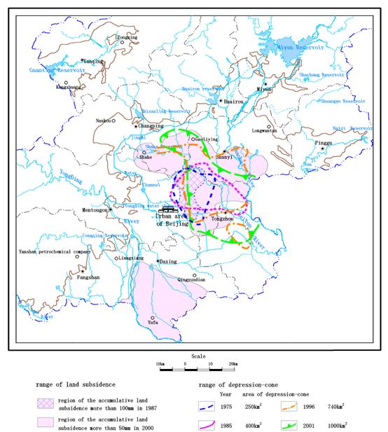
Figure 4 Distribution
of groundwater depression-cones and land subsidence in Beijing plain area
6.3 Establishments of emergent
well fields
Since 1999, Beijing continuously encounters drought for 7
years, which makes the available quantity of surface water reduce rapidly.
North China where Beijing locates also belongs to the water
shortage area, and it is only probable to divert quite little regulative water
from its river systems, which enhances the situation of water shortage in Beijing.
Utilizing adequately the huge groundwater storage and its strong regulative
capacity to establish emergent well fields is one of the effective ways to
lighten the pressure of water supply. Beijing Institute of Hydrogeological and
Geological Engineering presents four emergent well fields (figure 3) and their
exploitation patterns (table 3), which can increase water supply quantity of 83 ´104m3/d for Beijing.
Now the Lianghe emergent well field in Huairou and Wangduzhuang
emergent well field in Pinggu have been officially connected with the water
supply net system and supplied water for Beijing,
which plays a key role for lightening the pressure of water supply in the
latest years. The observed water table data of emergent well fields in
operation show that, their exploitation has caused continuous groundwater
drawdown in part of area, which indicates that the exploitation comes mainly
from groundwater storage. After the South-North Water Diversion Engineering is
implemented, it can make the water level and storage come up again by stopping
pumping of these well fields. As the reserved water source, emergent well
fields can greatly improve the assurance of municipal water supply, and are
helpful to groundwater-surface water conjuncttive use, which will improve the
efficiency of water resource utilization.
Table 3 Surveys of emergent well fields
|
Number
|
Well
field
|
Exploitation
layer
|
Exploitation
capacity(104m3/d)
|
Note
|
|
Ⅰ
|
Lianghe
emergent well field in Huairou
|
The
Quaternary pore water
|
33
|
Construction
of 21 pairs of wells has been completed. Deep and shallow wells are used
together and have been officially connected with the water supply net system.
|
|
Ⅱ
|
Pinggu
emergent well field
|
The
Quaternary pore water and Karstic water
|
30
|
Wangduzhuang
Emergent Well Field has officially supply water with the amount of 18×104m3/d.
Zhongqiao Emergent Well Field is in construction.
|
|
Ⅲ
|
Xishan
Karstic well field
|
Ordovician
Karstic water
|
10
|
Using
adequately the existing wells in the Third Water Works to distribute new
wells and in construction now.
|
|
Ⅳ
|
Fangshan
Karstic emergent well field
|
Wumishan
Karstic water
|
10
|
In
construction with ten wells completed.
|
6.4
Groundwater-Surface water conjunctive use
Dominated by southeast monsoon climate, the precipitation and
surface runoff in Beijing distribute unevenly in a year, and
vary greatly from year to year. Continuous dry years and continuous wet years
appear sometimes, which result in alternant occurrences of drought and
waterlog, and badly threaten municipal water supply security. It’s advisable to
take full advantage of the huge groundwater storage and capacity. In dry years
groundwater can be moderately over exploited, and in wet years it can be
recharged through groundwater-surface water conjunctive use. This can increase
the groundwater safe yield, improve the assurance of municipal water supply,
and relieve the geological and environmental problems caused by continuous
groundwater drawdown.
The UMPAFs in Yongding River and in Chaobai River are the areas with best
groundwater-bearing and maximum exploitation intensity in Beijing.
Over-exploitation for many years has released huge space for groundwater
recharge. With Yongding River and its upriver Guanting Reservoir as
well as Chaobai River and Miyun Reservoir upriver as
recharge sources respectively, and taking riverways and large-area sand and
rock pits as recharge fields, the two UMPAFs are the best suitable places for
artificial recharge to groundwater. According to calculations[21],
the groundwater capacity of UMPAF in Yongding River is 6.24 ´108m3, and the area of its
reservoir is 333km2;
the capacity of UMPAF in Chaobai River is 6.00´108m3 and
the area of its reservoir is 391km2.
In addition, there are many middle and small reservoirs in Beijing.
They discharge certain amount of water in the flood seasons every year due to
poor regulative capacity. This part of water can be fully used to recharge
groundwater through riverways, channels, sand pits and large open wells. The
completed work shows good results of recharge [12-14,
27-28].
6.5
Groundwater reasonable development after the south-north water diversion
engineering supply water
There will be some water surplus after the South-North Water
Diversion Engineering supplies water to Beijing.
Under this condition groundwater exploitation should be reasonably reduced or
partly stopped, and at the same time it should be recharged by the natural and
artificial ways, to make seriously over-exploited groundwater replenished
gradually. The main principles are: (1) In the areas of serious
over-exploitation, the pumping must be greatly limited. Close part of
industrial self-provided wells in the suburbs and reduce exploitation of water
works in the urban area. Change the agricultural structure in the Mi-Huai-Shun
area of the UMPAF in Chaobai River,
such as returning farmland to forest and grass. Reduce agricultural
exploitation, conserve groundwater and improve ecological environment.
Guarantee industrial and domestic water in urban areas and the satellite towns.
(2) In the areas of serious land subsidence, groundwater exploitation in the
deep layers should be reduced greatly to control the land subsidence, such as
in the eastern suburbs and Yufa of Daxing. (3) In the areas where the
ecological environment related to groundwater need to be recovered, groundwater
exploitation should be reasonably reduced, such as in riverways and the areas
around it, and natural and artificial wetlands.(4)In the areas where groundwater quality is relatively poor, it
should be used for other purposes instead of as drinking water.
Some
work, such as groundwater reasonable exploitation and its environmental
assessment after the South-North Water Diversion supplies water, has been done[21],
but there are still many problems worth further research, like the
determination of optimal amount and area of stopped exploitation; the range and
area of water level re-rising after stopping exploitation and its impact on
environment (wetlands recovery, building floating resistance and soaking, waste
soaking in informal landfill fields [29],
etc).
7
Conclusions
Groundwater resource in Beijing is rich, especially in UMPAFs in Yingding River and Chabai River in the plain area. The average
groundwater recharge for multi-year is 35.98×10⁸m3/a
in the whole area, among which 27.66 ´108m3/a is in the plain area.
The annual mean safe yield is 26.33 ´108m3/a, with 24.55 ´108m3/a in the plain area.
In
the recent 20 years, the total exploited groundwater is 26-28 ´108m3/a in the plain area of Beijing.
Because of long-time over-exploitation, the groundwater storage
has been reduced by 70×108m3,
and the depression-cone covering nearly 1000km2 has formed, which resulted in
land subsidence with more than200mm accumulative amount reaching 350km2.
Moreover, the quality of groundwater in the shallow layers is poor in the urban
area and Daxing. The major exceeding indexes are the Total Hardness, TDS and
Nitrate Nitrogen.
Before
the South-North Water Diversion can supply water, the situation of water
shortage must occur in Beijing.
The construction of 4 emergent well fields can increase 83×104m3/d
water for Beijing,
which greatly lightens the pressure of water supply.
The
utilization efficiency and safe yield of groundwater can be improved by supplying
water according to different quality and groundwater-surface water conjunctive
use. The groundwater reservoirs in the UMPAFs respectively in Yongding River and Chabai River are the best suitable places for
recharge due to their huge capacity, enough water source and good infiltration
ways.
After the South-North Water Diversion supplies water, groundwater
level and storage can come up again and its environment can be improved through
reasonably reducing exploitation or stopping it. As the reserved water source
for Beijing,
the completed emergent well fields have improved the assurance of municipal
water supply.
References
[1] Beijing Committee of Local Chronicle
Compilation. Beijing Chronicle----Volume of Geology, Mines,
Hydrology and Meteorology. Beijing: Beijing Publishing House, 2001: 153-182.
[2] Integrative Reconnaissance Report (General Surveys) on
Hydrogeology and Engineering Geology of Beijing, Beijing Institute of
Hydrogeological and Geological Engineering, 1955.
[3] Reconnaissance Report on Hydrogeology of Beijing for Water Supply in 1958, Beijing
Institute of
Hydrogeological and Geological Engineering, 1958.
[4] Reconnaissance and Study Report on Hydrogeology for Water
Supply in the Central Area of Beijing, Beijing Institute of Hydrogeological and
Geological Engineering, 1964.
[5] Reconnaissance Report on Hydrogeology for Water Supply in
Kunming Lake Well Field, Beijing Institute of Hydrogeological and
Geological Engineering, 1966.
[6] Reconnaissance Report on Hydrogeology for Water Supply in the
Mi-Huai-Shun Plain Area of Beijing, Beijing Institute of Hydrogeological and
Geological Engineering, 1975.
[7] Study Report on Groundwater Artificial Recharge in
Changxindian of Beijing, Beijing Institute of
Hydrogeological and Geological Engineering, 1965.
[8] Experimental Studies on Atmosphere Refrigeration and
Groundwater Artificial Recharge (recharge in winter and utilization in summer),
Beijing Institute of Hydrogeological and Geological Engineering, 1972.
[9] Experimental Study Report on Groundwater Artificial Recharge
through Sand and Rock Pit in Xihuang Village in the Western Suburb of Beijing,
Beijing Institute of Hydrogeological and Geological Engineering, 1980.
[10] Report on Calculation and Assessment of Water Resources in Beijing,
Beijing Institute of Hydrogeological and Geological Engineering, 1982.
[11] Calculation and Assessment of Groundwater Resources in Beijing,
Beijing Institute of Hydrogeological and Geological Engineering, 1998.
[12] Study Report on Groundwater Reservoir Experiments in West
suburb of Beijing, Beijing Institute of
Hydrogeological & Geological Engineering, 1985.
[13] Study Report on Underground Dispatching Experiments of Water
Resources in Niulan Mountain Area near Chaobai River of Beijing, Beijing Institute of Hydrogeological & Geological Engineering, 1987.
[14] Reconnaissance Report on Groundwater Dispatching in Beijing,
Beijing Institute of Hydrogeological &
Geological Engineering, 1991.
[15] Report on Geological Environment Investigation in Beijing,
Beijing Institute of Hydrogeological & Geological Engineering, 1998.
[16] Report on Land Subsidence Investigation of the Alarm and
Forecast System of Beijing Land Subsidence
Monitoring Net Project (first period), 2005.
[17] Feasibility Report on the Alarm and Forecast System of
Beijing Land Subsidence Monitoring Net Project (second period), 2006.
[18] Feasibility Report on Lianghe Emergent Well Field in Huairou
of Beijing, Beijing Institute of Hydrogeological & Geological Engineering,
1996.
[19] Reconnaissance Report on Hydrogeology for Bedrock Groundwater
Supply of Pinggu Emergent Well Field Engineering in Zhongqiao Area, Beijing
Institute of Hydrogeological & Geological Engineering, 2004.
[20] Investigation and Assessment of Groundwater Resource and Its
Environment in the Capital Area, Beijing Institute of Geology Investigation,
Hebei Institute of Geology Investigation, China University of Geosciences
(Beijing), Beijing Institute of Hydrogeological & Geological Engineering,
2003.
[21] Investigation and Assessment of Environmental and Geological
Problems in South-North Water Diversion (Beijing Part), Beijing Institute of
Hydrogeological & Geological Engineering, 2004.
[22] Groundwater Observing
Almanac, Beijing Institute of Hydrogeological & Geological Engineering,
1981.
[23] Phased Report on Experimental Studies of Phreatic Water
Evaporation and Precipitation Infiltration at the Liaogongzhuang Groundwater
Balance Test Field in the Western Suburb of Beijing, Beijing Institute of
Hydrogeological & Geological Engineering, 1981.
[24] Study Report on Water Using Investigation and Water Demand
Prediction of Beijing, Research Group of Water Using Investigation of Beijing,
2002.
[25] Chen Mengxiong, Ma Fengshan. Groundwater Resources and Its
Environment in China. Beijing:
Geological Publishing House, 2002, 32-36.
[26] Feasibility Report on Karstic Groundwater Resource and Its
Exploitation and Utilization in Beijing, Beijing Geology and Mineral Resources
Prospecting and Developing Bureau, Institute of Geology and GeophysicsChinese Academy of Sciences, 2001.
[27] Feasibility Report on the Engineering of Retaining Flood for
Recharge in West Suburb of Beijing, Beijing Planning and Design institute of
water resources, 1999.
[28] Experimental Report of Groundwater Artificial Injection with
Large-diameter Wells in the Area of Capital Steel Company, Beijing Institute of
Hydrogeological & Geological Engineering, 1981.
[29] Investigation and Assessment of Landfill Field’s Current
Situation and Its Influence to Groundwater in West Suburb of Beijing, Beijing Institute of Hydrogeological & Geological Engineering, 1999.
5 �p>��C��Bpan>
References
[1] Beijing Committee of Local Chronicle Compilation. Beijing Chronicle----Volume of Geology, Mines, Hydrology and Meteorology. Beijing: Beijing Publishing House, 2001: 153-182.
[2] Integrative Reconnaissance Report (General Surveys) on Hydrogeology and Engineering Geology of Beijing, Beijing Institute of Hydrogeological and Geological Engineering, 1955.
[3] Reconnaissance Report on Hydrogeology of Beijing for Water Supply in 1958, Beijing Institute of
Hydrogeological and Geological Engineering, 1958.
[4] Reconnaissance and Study Report on Hydrogeology for Water Supply in the Central Area of Beijing, Beijing Institute of Hydrogeological and Geological Engineering, 1964.
[5] Reconnaissance Report on Hydrogeology for Water Supply in Kunming Lake Well Field, Beijing Institute of Hydrogeological and Geological Engineering, 1966.
[6] Reconnaissance Report on Hydrogeology for Water Supply in the Mi-Huai-Shun Plain Area of Beijing, Beijing Institute of Hydrogeological and Geological Engineering, 1975.
[7] Study Report on Groundwater Artificial Recharge in Changxindian of Beijing, Beijing Institute of
Hydrogeological and Geological Engineering, 1965.
[8] Experimental Studies on Atmosphere Refrigeration and Groundwater Artificial Recharge (recharge in winter and utilization in summer), Beijing Institute of Hydrogeological and Geological Engineering, 1972.
[9] Experimental Study Report on Groundwater Artificial Recharge through Sand and Rock Pit in Xihuang Village in the Western Suburb of Beijing, Beijing Institute of Hydrogeological and Geological Engineering, 1980.
[10] Report on Calculation and Assessment of Water Resources in Beijing, Beijing Institute of Hydrogeological and Geological Engineering, 1982.
[11] Calculation and Assessment of Groundwater Resources in Beijing, Beijing Institute of Hydrogeological and Geological Engineering, 1998.
[12] Study Report on Groundwater Reservoir Experiments in West suburb of Beijing, Beijing Institute of
Hydrogeological & Geological Engineering, 1985.
[13] Study Report on Underground Dispatching Experiments of Water Resources in Niulan Mountain Area near Chaobai River of Beijing, Beijing Institute of Hydrogeological & Geological Engineering, 1987.
[14] Reconnaissance Report on Groundwater Dispatching in Beijing, Beijing Institute of Hydrogeological &
Geological Engineering, 1991.
[15] Report on Geological Environment Investigation in Beijing, Beijing Institute of Hydrogeological & Geological Engineering, 1998.
[16] Report on Land Subsidence Investigation of the Alarm and Forecast System of Beijing Land Subsidence
Monitoring Net Project (first period), 2005.
[17] Feasibility Report on the Alarm and Forecast System of Beijing Land Subsidence Monitoring Net Project (second period), 2006.
[18] Feasibility Report on Lianghe Emergent Well Field in Huairou of Beijing, Beijing Institute of Hydrogeological & Geological Engineering, 1996.
[19] Reconnaissance Report on Hydrogeology for Bedrock Groundwater Supply of Pinggu Emergent Well Field Engineering in Zhongqiao Area, Beijing Institute of Hydrogeological & Geological Engineering, 2004.
[20] Investigation and Assessment of Groundwater Resource and Its Environment in the Capital Area, Beijing Institute of Geology Investigation, Hebei Institute of Geology Investigation, China University of Geosciences (Beijing), Beijing Institute of Hydrogeological & Geological Engineering, 2003.
[21] Investigation and Assessment of Environmental and Geological Problems in South-North Water Diversion (Beijing Part), Beijing Institute of Hydrogeological & Geological Engineering, 2004.
[22] Groundwater Observing Almanac, Beijing Institute of Hydrogeological & Geological Engineering, 1981.
[23] Phased Report on Experimental Studies of Phreatic Water Evaporation and Precipitation Infiltration at the Liaogongzhuang Groundwater Balance Test Field in the Western Suburb of Beijing, Beijing Institute of Hydrogeological & Geological Engineering, 1981.
[24] Study Report on Water Using Investigation and Water Demand Prediction of Beijing, Research Group of Water Using Investigation of Beijing, 2002.
[25] Chen Mengxiong, Ma Fengshan. Groundwater Resources and Its Environment in China. Beijing: Geological Publishing House, 2002, 32-36.
[26] Feasibility Report on Karstic Groundwater Resource and Its Exploitation and Utilization in Beijing, Beijing Geology and Mineral Resources Prospecting and Developing Bureau, Institute of Geology and GeophysicsChinese Academy of Sciences, 2001.
[27] Feasibility Report on the Engineering of Retaining Flood for Recharge in West Suburb of Beijing, Beijing Planning and Design institute of water resources, 1999.
[28] Experimental Report of Groundwater Artificial Injection with Large-diameter Wells in the Area of Capital Steel Company, Beijing Institute of Hydrogeological & Geological Engineering, 1981.
[29] Investigation and Assessment of Landfill Field’s Current Situation and Its Influence to Groundwater in West Suburb of Beijing, Beijing Institute of Hydrogeological & Geological Engineering, 1999.


