


Achievements
RESEARCH ON CONJUNCTIVE USE OF SURFACE WATER AND GROUNDWATERIN BEIJING PLAIN
Xie Zhenhua1,Cui-yu1,Xu Miaojuan1,Cui Yali2,Xing Guozhang1
1 Beijing Institute of
Hydrogeological & Geological Engineering, Beijing, 100037;
2 China University of
Geosciences, Beijing, 100083
Abstract: The location,
water source, methods and effects of groundwater-surface water conjunctive use
in Beijing Plain are focused on in this paper. The analysis of Hydrogeological
conditions indicates the upper and middle parts of the alluvial-pluvial fans of
Yongding River and Chaobai River are the best suitable places for groundwater
recharge because of large storage, plenteous surface water source, high
infiltration capacity and good pumping facilities. The capacities of the
groundwater reservoirs in the two fans are 6.24×10⁸m3 and
6×10⁸m3 respectively. Moreover, in wet year a mass
of water is discharged from Miyun Reservoir and Guanting Reservoir for
preventing flood, which can be used as artificial recharge water source. The
modes of groundwater recharge include riverway, plain reservoir, sand pit,
large open well and infiltration gallery and so on. Furthermore, the
suggestions of groundwater development are put forward for South-North Water
Diversion. The results of groundwater numeric modeling on two alluvial-pluvial
fans indicate that groundwater is replenished through groundwater-surface water
conjunctive use. It can not only increase groundwater safe yield, but can also
improve assurance of municipal water supply and avoid geological and
environmental problems resulted from continual groundwater drawdown.
Key words: groundwater
reservoir, conjunctive use, groundwater
model, Yongding River, Chaobai River
Dominated by southeast monsoon climate, the precipitation and surface runoff in Beijing distribute unevenly in a year, and vary greatly from year to year. Continual dry years and continual wet years appear sometimes, which result in alternant occurrences of drought and waterlog, and badly threaten municipal water supply security. Groundwater recharge can not only increase its safe yield, but can also improve assurance of municipal water supply and compensate deficit of its storage, and avoid geological and environmental problems resulted from continual groundwater drawdown. Groundwater-surface water conjunctive use will improve the efficiency of water resource utilization, and realize mutual supplement of exploitation and utilization of surface water and groundwater [1-4] in space and time.
Since 1970s, many
experiments of groundwater artificial recharge in different infiltrative
patterns have been made in UMPAF of Yongding River
and Chaobai River [5-10]. All the experiments and
researches have promoted the study of this area.
1.Hydrogeology of Groundwater Reservoirs
In the upper and
middle parts of the alluvial-pluvial fans (UMPAF) of all main rivers
in Beijing, the aquifers are mostly made up of monolayer or dual layers of
sand and gravel, which are coarse-grained, very thick and rich in water, and
have the perfect space for groundwater storage. Researches indicate that,
over-exploitation of groundwater for many years has released huge space, and
UMPAF of Chaobai River and YongdingRiver, which are the two biggest
groundwater reservoirs in Beijing, are especially the best suitable places
for artificial groundwater recharge.
1.1 Groundwater reservoir in Yongding River
The groundwater
reservoir lies in UMPAF of Yongding
River. West Mountain in Beijing forms the reservoir’s
impervious west and northwest boundaries, which are made up of sand-shale and
lava of Carboniferous-Permian and Jurassic Periods. The east boundary is
along Kunming Lake, Zizhuyuan, Taoranting and Xihongmen from north to
south. The south boundary is from Xihongmen to Nangangwa through Langfa, and is
the natural boundary of groundwater, where the Quaternary lithology gradually
becomes fine-grained, the aquifers change from monolayer to multilayer with
permeability going down, and the groundwater type changes from phreatic water
to confined water. The bottom of the reservoir is also impervious for being
made up of Quaternary moraine mud gravel or Tertiary semi-cemented sand-gravel
and mudstone. So this area has the perfect conditions to form groundwater
reservoirs, see figure 1. The capacity of the groundwater reservoir
in Yongding River is 6.24×10⁸m3.
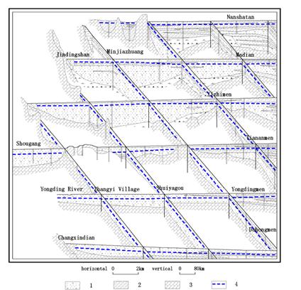
1. Quaternary
aquifers 2. aquitards 3.
bedrocks 4. phreatic water tables
Figure
1 Hydrogeologic united cross section of dispatching
in Yongding River catchment
1.2 Groundwater
reservoir in Chaobai River
The groundwater
reservoir lies in UMPAF of Chaobai River, with slope and pluvial deposits at
the piedmont on the east, north and west boundaries (The lithology is
farraginous and the permeability and storage capability are poor). The east and
west boundaries are located at the front edges of the second terrace of Chaobai
River, and have poor connectivity with the first terrace, so can be regarded as
relatively impervious boundaries. The south boundary is from Xiangyang Strobe
to Maxinzhuang, and it is the outflow area of groundwater, where the lithology
becomes finer, flow section comes narrower, and thickness of the aquifer is
smaller. In fact it is a relatively flow-obstructive barrier. North of the
groundwater reservoir’s bottom is bedrock, and south of it is distributed by a
more than 15m thick, stable clay sand and sandy clay layer at the
depth of 90-100m underneath the ground, which forms a relatively
impervious boundary, see figure 2. The two groundwater reservoirs in Chaobai River already
have huge regulative space for water recharge after many years’ exploitation.
The capacity is 6×10⁸m3 according to the calculation
result.
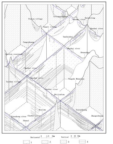
1. Quaternary
aquifers 2. aquitards 3.
bedrocks 4. phreatic water tables
Figure
2 Hydrogeologic united cross section of dispatching
in Chaobai River catchment
2 Capacity and Water Source of Groundwater Reservoirs
2.1 Capacity
2.1.1 Riverway
infiltration experiment
Yongding Riverway
infiltration: Guanting Reservoir discharged water in demand of controlling
flood from October 1995 to June 1997, and there was 3.6×10⁸ m3 water
infiltrating and recharging groundwater in the riverway from Sanjiadian Strobe
to Lugouqiao Strobe. Consequently the groundwater level in the area along this
part of Yongding River increased greatly, with the maximum range
of 15m, and average of about 3-5m, which greatly lightened the situation
of groundwater shortage in Fengtai area.
Chaobai Riverway
infiltration: Miyun Reservoir discharged 4×10⁸ m3 water from late
April to late June in 1995, with 10324×104 m3 water infiltrating
into groundwater in the riverway. So the storage quantity of aquifers was
increased by 8824×104 m3,
and the groundwater levels generally went up. The levels in the north area of
Xiangyang Strobe rose 1.3m in average and 6m at the
maximum.
Block engineering
in the riverway: at present, there are two rubber-dams and Lugouqiao
Flood-sharing Strobe constructed above the Yongding Riverway, and six
rubber-dams and Xiangyang Strobe constructed above the Chaobai Riverway. Those
hydrolic engineerings can retain certain quantity of discharged water from
reservoirs and mountain flood, which can infiltrate into ground and recharge
groundwater at a certain extent.
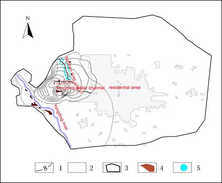
2.1.2 Sand
pit infiltration in Xihuang village
The sand pit in
Xihuang village lies at the top part of the alluvial-pluvial fan in Yongding
River, with an area of 2.82×10⁴ m2 and the maximum volume of 22.8×10⁴ m3, and its
infiltrative capacity is about 10m/d. Discharged water from Miyun Reservoir
was diverted to Yongding Water Channel via East-West Water Diversion
Engineering from April 21st to August 1st in 1995, then transferred to the sand
pit for recharge eventually. The groundwater was recharged by 1718×104 m3 in
total, and the infiltration capacity of the sand pit was 1.0 m3/s
or so. The monitoring results of water level and quality indicated that, sand
pit infiltration made important effect on controlling groundwater drawdown
around, and the groundwater quality was improved after surface water
infiltration.
2.1.3 Large
open well experiment near Shougang
Shougang is
located at the top part of the alluvial-pluvial fan
in Yongding River. The aquifer there is single layer of
coarse-grained sand gravel. The depth of groundwater level in this area had
already been over 30mwhen making experiments in 1980. The large open well
is 25m in depth and 8m in diameter. The experimental
recharge rate could reach 0.5m3/s, and with the recharge time
going longer, the well was stagnated and the recharge rate descended gradually.
The recharge
experiments in the above three patterns have proved they have great effects and
can be directly applied to engineering construction. Therefore, if surface
water is abundant, we can retain and store it through dispatching engineering,
recharge it into the ground and increase groundwater storage quantity, which
will reduce the problems such as groundwater drawdown in large areas resulted
from continual over exploitation.
2.2 Water source
2.2.1 Groundwater
reservoir in Yongding River
Yongding Riverway
flows from northwest to southeast across east of its UMPAF, and the Yongding
Water Channel diverting water from Sanjiadian Strobe extends from east to west
at the piedmont. Jingmi Water Channel flows through northeast of this area, to
west Balizhuang then joins into Yongding Water Channel, and goes into Yuyuantan
Lake at last. So, surface water sources that can take part in recharge at UMPAF
of Yongding River include discharged flood from mountains within the area
of 1520km2 from Guanting to Sanjiadian, discharged water
from Guanting Reservoir to Yongding River and discharged water
from reservoirs along Jingmi Water Channel. Considering on the distance of
water diversion, discharged flood from mountains in Yongding River and
discharged water from Guanting Reservoir are more convenient to be selected as
conjunctive use water source with groundwater. This part of water source is
discharged to lower reaches through Sanjiadian Strobe, and the discharge
quantity changes with precipitation, see table 1.
Table
1 Annual discharge quantity of Sanjiadian
Strobe from 1994 to
1997 unit: 104m3
|
Year |
1994 |
1995 |
1996 |
|||||||||||||||
|
Month |
April |
July |
August |
total |
October |
November |
December |
total |
January |
May |
June |
|||||||
|
Discharge quantity |
200.87 |
184.56 |
306.9 |
692.33 |
4142.01 |
4080.8 |
8222.8 |
16445.61 |
6289.9 |
4903.22 |
847.07 |
|||||||
|
Year |
1996 |
1997 |
||||||||||||||||
|
Month |
July |
August |
September |
October |
November |
total |
May |
June |
July |
August |
total |
|||||||
|
Discharge quantity |
3922.55 |
8636.54 |
6948.32 |
7034.71 |
2173.74 |
28715.90 |
3103.83 |
1846.74 |
289.45 |
147.14 |
5387.16 |
|||||||
2.2.2 Groundwater reservoir
in Chaobai River
The main surface water sources of this area for recharge come from Miyun Reservoir and Huairou reservoir, and other four middle and small reservoirs, Huairou Reservoir can be regarded as the adjustive reservoir for Miyun. Dashuiyu and Beitaishang Reservoirs can be connected with Miyun and Huairou Reservoirs through Jingmi Water Channel, which will realize uniform control and dispatch of surface water sources. Shachang Reservoir is at the east of Chaobai River, connective with it by the trunk of Chao River. Precipitation in 1995 was comparatively abundant, so Miyun Reservoir discharged about 4×10⁸m3 water to the riverway, and the other four reservoirs discharged 0.22×10⁸m3 water( table 2).
Table
2 Discharge quantity of
middle and small reservoirs from
1981-2000 unit: 108m3
|
Year |
1981 |
1982 |
1983 |
1984 |
1985 |
1986 |
1987 |
1988 |
1989 |
1990 |
|
Dashuiyu Reservoir |
0.00 |
0.11 |
0.10 |
0.00 |
0.12 |
0.12 |
0.17 |
0.19 |
0.00 |
0.00 |
|
Beitaishang Reservoir |
0.01 |
0.00 |
0.00 |
0.00 |
0.00 |
0.00 |
0.00 |
0.05 |
0.00 |
0.00 |
|
Shachang Reservoir |
0.00037 |
0.27 |
0.0023 |
0.00 |
0.43 |
0.13 |
0.51 |
0.24 |
0.08 |
0.32 |
|
Year |
1991 |
1992 |
1993 |
1994 |
1995 |
1996 |
1997 |
1998 |
1999 |
2000 |
|
Dashuiyu Reservoir |
0.18 |
0.06 |
0.0088 |
0.20 |
0.02 |
0.18 |
0.0004 |
0.15 |
0.00 |
0.00 |
|
Beitaishang Reservoir |
0.00 |
0.025 |
0.00 |
0.10 |
0.00 |
0.32 |
0.11 |
0.13 |
0.04 |
0.01 |
|
Shachang Reservoir |
0.16 |
0.18 |
0.03 |
0.39 |
0.21 |
0.06 |
0.00 |
0.02 |
0.00 |
0.00 |
3 Suggestions for
Conjunctive Use
3.1Groundwater-Surface
water conjunctive use before the water source from South-North water diversion
coming into Beijing
In the case of no
diverted water source outside Beijing,,the water supply must rely on its
own water resource, and then the emergent well fields have to be established in
recent years. The quantity of groundwater exploitation can be enlarged based on
the actual demands, and the contradiction between supply and demand can be
resolved by emergent water sources. But the emergent water sources can’t be
exploited without limitation. It must be stopped at first when surface water is
enough. If the emergent well fields and the surface water reservoirs can be
connected by water plants and water transferring pipelines, then it is more
helpful to the conjunctive use of these two part water resources.
3.1.1 The
conjunctive use between the Huarou Emergent Well Field and the reservoirs in
Miyun and Huairou
The Lianghe
emergent well field in Huairou lies on the alluvial-pluvial fan
of Huai River, which is a part of the alluvial-pluvial fan
in Chaobai River. It is east to Huairou Reservoir, and near to Jingmi
Water Channel and the water intake at Huairou Reservoir of the Ninth Water
Plant. The emergent water source adopted the solid groundwater exploitation
scheme with deep-shallow wells combination, and 21 pairs of wells (42 pieces)
were constructed. The estimated capacity of annual emergent water supply is
1.2×10⁸m3/a.
When municipal
water supply is seriously deficient, water in the emergent well field will be
exploited and transferred into the existing water supply pipelines net (the
Ninth Water Plant). And the project will be started up in order to supply water
to urban Beijing.
3.1.2 The
conjunctive use between Pinggu Emergent Well Field and Haizi Reservoir
The emergent well
field is in the areas of Wangduzhuang-Magezhuang and Yukou-Zhongqiao on the
alluvial-pluvial fans of Ju River and Cuo River respectively,
with large storage capacity and good conditions for recharge, easy to be
exploited and replenished. The surface water can directly recharge groundwater
by riverways with the discharged water from Haizi Reservoir. It took the mode
of united exploitation both in Quaternary deposits and bedrocks, and the
estimated capacity of water supply is 27×104-30×104 m3/d,and about 1.0×10⁸m3/a
in a year. But it’s necessary to construct transferring-distributing pipelines
net for Beijingmunicipal water supply, at the same time it can reduce the
exploitation intensity of groundwater, using water of Haizi Reservoir replacing
the exploitation quantity of groundwater for agriculture and parts of
industries in the Pinggu Plain.
3.2Groundwater-surface
water conjunctive use after the water source from South-North Water Diversion
coming into Beijing
After the center
line of South-North Water Diversion transferring water into Beijing, it
will be apart of the municipal water supply system and distributed uniformly.
The distribution principles are: prior to use water from South-North Water
Diversion, and considering water from Miyun Reservoir secondly; prior to use
surface water and conserve groundwater, meanwhile storing water into Miyun
Reservoir and the aquifers, and eventually reaching the purpose of dispatching
water from South-North Water Diversion indirectly.
The planning urban
area will be located at UMPAF of Yongding River and at the end of the
South-North Water Diversion Engineering. The utilization of water from
South-North Water Diversion can replace the exploitation of groundwater at a
certain extent. And groundwater can be stored and conserved by reducing pumping
rate and stopping some self-prepared wells. Especially in the western suburb,
it is the strong recharge area for groundwater, and the aquifer is mainly
consisted of single sand and gravel, which is coarse grained, rich in water and
good for recharge. When the surface water supply increases, the effect of groundwater
conservation will be more obvious in the water levels.
In summarization,
groundwater-surface water conjunctive use can efficiently improve the
utilization degree of water resources, and reduce needless waste. The more
united dispatching is used, the more assurance of water supply we can get. It
is definitely a scientific and reasonable solution to resolve the increasingly
serious contradiction of water resources in Beijing.
4 Simulations of
Groundwater Reservoirs for Regulative Engineering’s Effects
4.1 Regulative
engineering of Yongding Water Channel - Nanhan River
Nanhan Riverway
(infiltration capacity can be up to 1 m3/s), the discarded sand
pits and large open wells along both sides of Nanhan Riverway and Yongding
Water Channel were taken as the recharge engineering. According to the
numerical modeling[11], it could provide water resources 2.59×10⁸m3 for
recharge. The recharge period lasted for three months, and the total
infiltration quantity is 2.07×10⁸m3 with the ratio
of 79.8%. During the late period of recharge, the groundwater levels rose
1-10m in the area, at which water source wells of the Third Water Plant
are located (figure 3).
1.rising range of
water level 2.residential area 3.regualtive
area 4.sand pit 5.large open well
Figure
3 the rising ranges of groundwater levels resulted in infiltration
of regualtive engineering of Yongding Water Channel-Nanhan river
4.2 Regulative
engineering of Huairou Emergent Well Field
The groundwater
levels in the area of the alluvial-pluvial fan
in Huai River declined due to exploitation of the emergent well
field. So the rubber dams were constructed on riverways of Huai, Yanqi and Sha
to store water so that the alluvial-pluvial fan
in Huai River could be recharged, and the discharged water from
reservoirs of Beitaishang, Dashuiyu, Huairou and Miyun was also used for this
reason. The modeling results indicated that the regulative engineerings could
provide water resources 1.08×10⁸m3,and the total infiltration quantity was
0.88×10⁸m3 with the ratio of 81.48%. During the late
period of recharge, the groundwater levels in the area of the emergent well
field rose 2-6m, and the effects even extended to the area of the eighth water
works, where the groundwater levels rose 2-4m near Niulan Mountain (figure
4). It effectively reduced a series of environment and geology problems
resulted in groundwater levels decreasing after the emergent well field was in
operation.
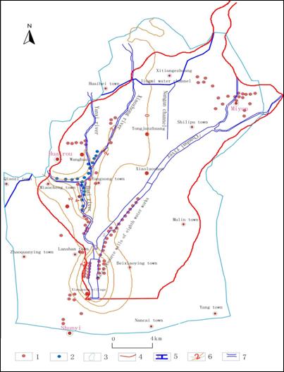
1. well
field 2. emergent well field 3. study area 4.
modeling area
5. rubber
dam 6. rising range of water level 7. Xiangyang Strobe
Figure
4 the rising ranges of groundwater levels resulted in infiltration
of the rubber dams on Huai Riverway
The estimating
results of the groundwater dispatching model of the alluvial-pluvial fans
in Yongding River and Chaobai River show that,
the artificial recharge of groundwater has good effects, and the engineering is
feasible. It has positive effects on groundwater replenishment, and also has
significant social and environmental benefits. So, it is necessary to
strengthen implementing studies on the groundwater-surface water united
dispatching after the South-North Water Diversion Engineering is put in
practice, and to try the best to implement it step by step after asking for opinions
of relevant departments.
References
[1] Qi Xuebin, Pang Hongbin, Zhao Hui, and Wang Jinglei. Present Situation
and Tendency of Conjunctive Ground Water and Surface Water Management. Advances
in Water Science, 1999, 10(1): 89-94.
[2] Joy Malsukawa. Conjunctive-use planning in Mad River
Basin California [J]. Journal of water resources planning and
management ASCE. 1992, 118(2): 1-10.
[3] Ding Kunlun. Study on Effective Way and Technology of
Artificial Recharge of Groundwater [J]. China Rural Water and Hydropower, 1996,(1-2): 14-17.
[4] Wu Xiaofeng, Tang Jie. Study on Artificial Recharge and Reusing of
Groundwater [J]. Geotechnical Investigation & Surveying, 1988, (4): 37-42.
[5] Beijing Institute of Hydrogeological & Geological Engineering, Study report on groundwater reservoir experiments in west suburb of Beijing, 1985.
[6] Beijing Institute of Hydrogeological & Geological Engineering, Study report on underground dispatching experiments of water resources in Niulan Mountain area near Chaobai river of Beijing, 1987.
[7] Beijing Institute of Hydrogeological & Geological Engineering, Reconnaissance report on groundwater dispatching in Beijing, 1991.
[8] Beijing Institute of Hydrogeological & Geological Engineering, Reconnaissance report on groundwater dispatching engineering for Beijing part of the middle line of South-North Water Diversion, 1997.
[9] Beijing Institute of Hydrogeological & Geological Engineering,
Work summarization on groundwater recharge through sand pit in Xihuang village,
1996, 1997.
[10] Beijing Planning and Design institute of water resources, Feasibility
report on the engineering of retaining flood for recharge in west suburb
of Beijing, 1999.