


Achievements
EVOLVING CHARACTERS OF GROUNDWATER RESOURCE IN NORTH-EAST MASTER PLAIN OF CHINA
DAI Chang-lei1 CHI Bao-ming2 YE Yong2 WANG Zhi-gang3
(1. College of Water Conservancy & Electric Power,
2. College of Environment & Resources, Jilin
University, Jilin
3. Ministry of Water Resources Songliao Committee Jilin
Abstract: With
the influence of monsoon climate, precipitation in north-east area of
As
one of the most famous large plains in
Based on the research about large scale phreatic cycle in inland and abroad before and the second national water resource integrated evaluating result finished by Ministry of Water Conservation, this paper statistics the groundwater recharge of every subarea in North-East Master Plain during 1956~2000 (totaling 45 years). It also analyses the regional groundwater resource and environment problems, and then, construes the nature and human affection on groundwater resource. At last, it points out the evolving characters of groundwater in these 45 years.
By choosing different elements to represent the nature evolvement and the effect of human activity, and discussing the groundwater resource evolving process and its related degree, this paper try to find out the coupling mechanism of groundwater resource in North-East Master Plain of China, illustrates the principles that groundwater system responses the exterior factors, such as nature evolvement and especial the human activity. The paper also forecasts the evolving direction of groundwater resource in North-East Master Plain, and brings forward some countermeasures and tactics to redress and control the groundwater resource by human.
This paper has certain reference value to
sustainable utilizing ground water resource and social economy sustainable
development in northeast area of
Key Words: North-East Master Plain; Groundwater Resource; Evolving; Nature Evolvement; Human Activity
Problem Introduction
In Monsoon
climate area, as a result of the tempestuously change with the time of the atmospheric
precipitation, the ground water aquifer not only supply a great deal of fresh
water for human manufacture and living, but also recharge surface water to
maintain the river base flow in low flow season. The ground water resource
takes an important role in water resources system. The North-East Master Plain
is one of the most noted three big plains in
Taking the North-East Master Plain for example, according to the second national water resource integrated evaluating result finished by Ministry of Water Conservation, this paper analyses the evolving characters of groundwater on a large scale view and discusses the relationship between environment change and human activity influence and these characters.
Hyrogeologic Features Analysis
As
the meaning of its name, the North-East Master Plain situates on such area
crossing Liaoning
Province, Jilin Province,
The
North-East Master Plain is consisted
of Liaohe Plain, Songnen Plain and Sanjiang Plain. Thereinto, the Liaohe Plain
connects the Songnen Plain as a whole, and then named as Songliao Plain. The
Sanjiang Plain also connects the Songliao Plain by a section of cabined plain
between mountains. DaXingAnLing mountain chain lies at the northwest of North-East Master Plain, and the northeast of it is XiaoXingAnLing Mountain
and Heilongjiang River
and Wusulijiang River,
which are the boundary river between
The hydrogeologic features of the North-East Master Plain can be divisionally introduced as fellows:
Liaohe Plain
The Liaohe Plain is divided into four parts: East Liaohe Plain, West Liaohe Plain, Middle Liaohe Plain and Low Liaohe Plain. The total area is 9.21×10⁴km2.

Fig.1 location and space distribution map
of North-East Master Plain
The East Liaohe Plain mainly constitutes of hill, alluvial flat and first & second terrace. Ground water occurrences mostly in the pore space of sand and sandy gravel in incompact rock aquifer and the fissure of cretaceous clastic rock aquifer.
The
West Liaohe Plain is a downwarp basin with the low open region lies at the
southeast side. It borders on Songnen Plain in the north and east sides. The
northeast is the mountainous region of
The Low Liaohe Plain is circled by massif at west, north and east sides. The central section of the Low Liaohe Plain is amplitude depressed basin, and descends all through the YanShan construct period. Consequently, huge thick clastic fragment of cretaceous, tertiary system and quaternary system are deposited in this basin. The pore phreatic water and confined water distribute at the central section, and the east and west sides distribute pore phreatic water which is in girdle and zonal distribution. Owing to the raising of Kangfa breck, the north also distributes pore phreatic water. The hydrogeologic features of the entire Low Liaohe Plain can be summarized as follows: the east, west and north sides are the zone of recharge. The central section is pressurization runoff zone. The basin is a synclinal basin with the tertiary system basement inclining to the southwest. The aquifer is huge thick in vertical. The ground water type can be divided into pore phreatic water in incompact rock of quaternary system and pore fissure water in tertiary system.
Songnen Plain
The total
area of Songnen Plain is 19.91×10⁴km2. It is a large
scale reservoir basin with multilayer cascade structural confined aquifers,
which include the lower Pleistocene Series and Eocene Series (Yian formation of
Oligocene Series, Daan formation of Miocene Series, Taikang formation of
Pliocene Series) of Tertiary System. The Songnen Plain can be divided into four
hydrogeology regions: east high plain, middle low plain, west slope plain in
front of
Sanjiang Plain
With the total area of 4.58×10⁴km2,
the Sanjiang Plain is formed in Cenozoic and Mesozoic era. About 300m thick of loose sediment deposited since Quaternary
Period. The west, south and east sides of Sanjiang Plain is embosomed by hill.
The Sanjiang Plain is an alleviation and lacustrine plain formed by three
rivers which are the Heilongjiang River in the north, the Songhuajiang
River in the central and the
Table1 Hydrogeological Division in North-East Master Plain
|
Grade 1 |
Grade 2 |
Area (104km2) |
Proportion |
|
Liao He Plain |
East Liaohe Plain West Liaohe Plain Middle Liaohe Plain Low Liaohe Plain |
9.21 |
27.33% |
|
Song Nen Plain |
West slope plain in front of mountain Middle low Plain East high Plain Between mountains Plain |
19.91 |
59.08% |
|
San Jiang Plain |
Sanjiang low Plain MuLingXinKai low Plain |
4.58 |
13.59% |
|
Total |
33.70 |
100% |
Evolving Characters of the Quantity of Ground Water Resources and its Exploitation Countermeasures
To analyzing the evolving characters of quantity of ground water resources in large-scale, the quantity of ground water can be defined as the difference of the total quantity of ground water recharge and quantity of ground water irrigation. Thereinto, the quantity of ground water recharge can be gained by adding these eight items, which are recharge of rainfall penetration, recharge of river channel leakage, recharge of reservoir and pond leakage, recharge of trench leakage, recharge of field ditch leakage, artificial ground water recharge, lateral recharge in front of mountain, and recharge of ground water irrigation regression. Then, the equation can be described as follows.
Total recharge of ground water:
Qt=Qp+Qr+Qp+Qtl+Qf+Qa+Ql+Qi 1
Quantity of ground water resources:
Qgr=Qt-Qi 2
Modulus of ground water resources:
Mr=Qri/Ai 3
Where, in equation 1, the Qt is the total quantity of ground water recharge; Qp is recharge of rainfall penetration; Qr is recharge of river channel leakage; Qp is recharge of reservoir and pond leakage; Qtl is recharge of trench leakage; Qf is recharge of field ditch leakage; Qa is artificial ground water recharge; Ql is lateral recharge in front of mountain; Qi is recharge of ground water irrigation regression. In equation 2, Qgr is the quantity of ground water resource and the other symbols is the same meaning as in equation 1. In equation 3, Mr is the modulus of ground water resources; the Qri is the ground water recourses in particular region and the Ai is the corresponding area of that region.
Based on the second national water resource integrated evaluating result finished by Ministry of Water Conservation, choosing the corresponding data about ground water resources in northeast finished by Song-Liao Water Resources Commission Ministry of Water Resources, this paper statistics the quantity of ground water resources of every subarea in North-East Master Plain during 1956~2000 (totaling 45 years) and lists in table 2. According to the data, this paper analyses the evolving characters about ground water resources in North-East Master Plain in recent half century.
|
Table2 Quantity of Ground Water Resource Sequence of North-East Master Plain in 1956-2000 | ||||
|
Year |
Ground Water Resource(109m3/a) | |||
|
Liaohe Plain |
Songnen Plain |
Sanjiang Plain |
North-East Plain | |
|
1956 |
7.05 |
16.93 |
3.79 |
27.77 |
|
1957 |
6.35 |
16.69 |
4.40 |
27.44 |
|
1958 |
4.52 |
10.46 |
3.16 |
18.14 |
|
1959 |
7.44 |
13.65 |
4.77 |
25.86 |
|
1960 |
6.31 |
15.89 |
4.06 |
26.27 |
|
1961 |
4.99 |
12.42 |
2.96 |
20.36 |
|
1962 |
6.33 |
13.08 |
3.63 |
23.04 |
|
1963 |
5.77 |
15.51 |
3.77 |
25.04 |
|
1964 |
6.14 |
13.02 |
3.60 |
22.76 |
|
1965 |
4.30 |
13.37 |
4.14 |
21.80 |
|
1966 |
5.58 |
14.58 |
2.77 |
22.94 |
|
1967 |
4.04 |
10.93 |
2.52 |
17.49 |
|
1968 |
4.68 |
11.00 |
3.36 |
19.05 |
|
1969 |
7.61 |
14.76 |
3.28 |
25.65 |
|
1970 |
5.30 |
10.90 |
2.66 |
18.86 |
|
1971 |
5.85 |
13.21 |
4.39 |
23.45 |
|
1972 |
4.34 |
12.29 |
4.22 |
20.84 |
|
1973 |
5.33 |
12.60 |
3.70 |
21.63 |
|
1974 |
5.98 |
13.20 |
3.90 |
23.08 |
|
1975 |
5.22 |
11.13 |
2.28 |
18.64 |
|
1976 |
5.50 |
10.92 |
2.27 |
18.68 |
|
1977 |
6.73 |
13.33 |
2.12 |
22.18 |
|
1978 |
5.14 |
10.84 |
2.83 |
18.80 |
|
1979 |
6.47 |
10.89 |
2.40 |
19.75 |
|
1980 |
3.75 |
13.01 |
3.19 |
19.95 |
|
1981 |
5.33 |
15.24 |
4.87 |
25.45 |
|
1982 |
4.67 |
9.45 |
2.65 |
16.77 |
|
1983 |
6.05 |
14.35 |
3.26 |
23.66 |
|
1984 |
6.43 |
14.82 |
4.03 |
25.27 |
|
1985 |
7.53 |
16.28 |
3.50 |
27.30 |
|
1986 |
8.12 |
13.40 |
2.55 |
24.08 |
|
1987 |
6.21 |
16.00 |
4.14 |
26.34 |
|
1988 |
4.96 |
15.50 |
2.99 |
23.45 |
|
1989 |
3.85 |
10.35 |
3.05 |
17.26 |
|
1990 |
6.79 |
14.81 |
3.54 |
25.14 |
|
1991 |
7.54 |
15.33 |
4.02 |
26.89 |
|
1992 |
4.99 |
11.54 |
3.08 |
19.61 |
|
1993 |
5.39 |
14.74 |
3.22 |
23.35 |
|
1994 |
7.40 |
16.32 |
4.97 |
28.69 |
|
1995 |
5.44 |
10.17 |
2.91 |
18.53 |
|
1996 |
4.65 |
12.59 |
3.12 |
20.36 |
|
1997 |
4.54 |
13.30 |
3.32 |
21.15 |
|
1998 |
8.41 |
18.29 |
3.47 |
30.17 |
|
1999 |
3.82 |
10.80 |
2.10 |
16.72 |
|
2000 |
3.42 |
10.25 |
2.76 |
16.44 |
|
Average |
5.69 |
13.29 |
3.37 |
22.36 |
From table 2, the average quantity of ground water resources is 22.36 billion stere. The richest of ground water resources is Songnen Plain, and the second is Liaohe Plain, the last is Sanjiang Plain. But as we know, the area of Songnen Plain is the biggest, so, these numbers just represents the total number of ground water resources, not the ground water yield property.
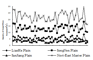
Fig.2 Evolvement Curve of Quantity of Ground Water Resource in North-East Master Plain
The relationship and characters of quantity of ground water resource sequence in North-East Master Plain can be seeing in figure 2. The ground water resources fluctuate round the average number. General trend is a horizontal line. The evolvement curve of Liaohe Plain resembles to the evolvement curve of Sanjiang Plain.
To determine the ground water yield property, the modulus of ground water resources should be given out. Table 3 lists the modulus sequence of ground water resources between 1956 year and 2000 year. The average modulus of ground water resources is 66.34 mm/a. Not the same to the quantity of ground water resources, the biggest number of modulus in North-East Plain is in Sanjiang Plain, which the value is 73.61 mm/a. The next is Songnen Plain which the modulus is 66.76 mm/a. The last is Liaohe Plain which the modulus is 61.83 mm/a.
|
Table 3 Modulus Sequence of ground water resources of North-East Master Plain in 1956-2000 | ||||
|
Year |
Modulus of ground water resources (mm/a) | |||
|
Liaohe Plain |
Songnen Plain |
Sanjiang Plain |
North-East Plain | |
|
1956 |
76.54 |
85.05 |
82.75 |
73.67 |
|
1957 |
68.97 |
83.84 |
96.06 |
72.80 |
|
1958 |
49.08 |
52.54 |
69.00 |
48.12 |
|
1959 |
80.78 |
68.54 |
104.20 |
68.59 |
|
1960 |
68.57 |
79.81 |
88.67 |
69.67 |
|
1961 |
54.16 |
62.38 |
64.53 |
54.02 |
|
1962 |
68.70 |
65.72 |
79.16 |
61.11 |
|
1963 |
62.61 |
77.89 |
82.21 |
66.42 |
|
1964 |
66.71 |
65.37 |
78.60 |
60.37 |
|
1965 |
46.67 |
67.13 |
90.29 |
57.83 |
|
1966 |
60.62 |
73.25 |
60.44 |
60.84 |
|
1967 |
43.88 |
54.89 |
55.05 |
46.39 |
|
1968 |
50.85 |
55.25 |
73.39 |
50.52 |
|
1969 |
82.58 |
74.15 |
71.70 |
68.04 |
|
1970 |
57.51 |
54.74 |
58.14 |
50.02 |
|
1971 |
63.47 |
66.34 |
95.92 |
62.19 |
|
1972 |
47.10 |
61.72 |
92.04 |
55.28 |
|
1973 |
57.92 |
63.29 |
80.68 |
57.37 |
|
1974 |
64.95 |
66.30 |
85.09 |
61.22 |
|
1975 |
56.70 |
55.91 |
49.88 |
49.44 |
|
1976 |
59.70 |
54.83 |
49.57 |
49.56 |
|
1977 |
73.09 |
66.96 |
46.30 |
58.84 |
|
1978 |
55.76 |
54.45 |
61.74 |
49.88 |
|
1979 |
70.20 |
54.69 |
52.33 |
52.39 |
|
1980 |
40.70 |
65.32 |
69.74 |
52.91 |
|
1981 |
57.90 |
76.55 |
106.38 |
67.50 |
|
1982 |
50.69 |
47.48 |
57.89 |
44.49 |
|
1983 |
65.74 |
72.06 |
71.17 |
62.76 |
|
1984 |
69.77 |
74.42 |
87.99 |
67.04 |
|
1985 |
81.72 |
81.75 |
76.38 |
72.42 |
|
1986 |
88.20 |
67.32 |
55.68 |
63.86 |
|
1987 |
67.39 |
80.36 |
90.34 |
69.88 |
|
1988 |
53.84 |
77.85 |
65.23 |
62.19 |
|
1989 |
41.83 |
51.98 |
66.69 |
45.77 |
|
1990 |
73.72 |
74.37 |
77.33 |
66.68 |
|
1991 |
81.82 |
77.01 |
87.84 |
71.33 |
|
1992 |
54.13 |
57.95 |
67.34 |
52.01 |
|
1993 |
58.52 |
74.05 |
70.22 |
61.93 |
|
1994 |
80.37 |
81.98 |
108.45 |
76.10 |
|
1995 |
59.12 |
51.09 |
63.57 |
49.15 |
|
1996 |
50.46 |
63.25 |
68.10 |
54.00 |
|
1997 |
49.25 |
66.78 |
72.49 |
56.11 |
|
1998 |
91.29 |
91.84 |
75.82 |
80.02 |
|
1999 |
41.42 |
54.27 |
45.88 |
44.35 |
|
2000 |
37.18 |
51.50 |
60.34 |
43.61 |
|
Average |
61.83 |
66.76 |
73.61 |
66.34 |
In the modulus sequence graph of ground water resources (Fig.3), the change is a little complex. The general change character of the modulus of ground water resources in three plains is consistent, especially since 1984. The trend is being lessening slowly. The biggest of amplitude of modulus is in Sanjiang Plain.
The sum-up of quantity and modulus of ground water resources in North-East Master Plain is listed in table 4. Songnen Plain has the biggest number of average ground water resources and its proportion, but Sanjiang Plain has the biggest number of modulus of ground water resources. At the same time, Sanjiang Plain has the biggest square deviation of modulus. So, the change of ground water resources is more tempestuously in Sanjiang Plain.
Except the quantity of ground water resources, the nature character in North-East Master Plain is described as follows. The North-East Master Plain locates in continental monsoon climate zone. Average annual precipitation is between 300mm and 1200mm, and descends from southeast to northwest. The
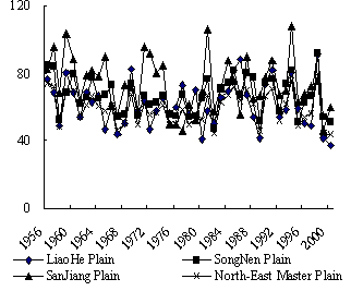
Fig.3 the Modulus Sequence graph of ground
water resources
Table 4 Quantity and Modulus of ground water resources in North-East Master Plain
|
Subarea Name |
Average (109m3/a) |
Propo- rtion |
Modulus (mm/a) |
Square deviation of Modulus |
|
LiaoHe Plain |
5.69 |
25.4% |
61.83 |
177.54 |
|
SongNen Plain |
13.29 |
59.4% |
66.76 |
119.26 |
|
SanJiang Plain |
3.37 |
15.2% |
73.61 |
252.49 |
|
Total |
22.36 |
100% |
66.34 |
139.26 |
precipitation mainly centralizes in summer which the precipitation from June to September occupies about 70% to 80% of the total precipitation in one year. The precipitation varies very much from year to year, and the Cv is between 0.1 and 0.3. Average evaporation is mainly between 900mm and 2000mm (using the 20cm evaporating dish observed), and increases by degrees from northeast to southwest.
The water resource in North-East Master Plain is indigence. The total average water resource of every people is only about 1/6 of it in world and 2/3 of it in nation. Water resource of one unit of infield is 588stere, and only 1/3 of it in nation. Along with the advancement of human society and development of economy, the demand of water resources increases ceaselessly. Lacking of water resource and declining of water quality is an ultimate problem in this area.
From the discussion above, several conclusions can be gained.
1. The ground water resources changes alternately in North-East Master Plain, but the variety trend is consistent.
2. The change extent of ground water resources in Sanjiang Plain is the biggest, Songnen Plain takes second place, and Liaohe Plain is the smallest.
3. Songnen Plain has the richest ground water resource that is 1.329 billion stere every year. Liaohe Plain is the second and it’s 0.569 billion stere every year. Sanjiang Plain is the smallest, which is only 0.337 billion stere every year. The entire master plain, the ground water resource is 2.236 billion stere every year.
4. As considering about the modulus, Sanjiang Plain is 73.61 mm/a; Songnen Plain is 66.76 mm/a; Liaohe Plain is 61.83 mm/a. The modulus of the whole plain is 66.34 mm/a.
5. Based on the data and the environment condition in North-East Master Plain, the change of ground water resources is mainly controlled by atmosphere precipitation; the quantity of resource is mainly influenced by the structure and boundary condition of hydrogeology unit; the change extent of ground water resources is mainly affected by human exploitation; the modulus is controlled by both precipitation and hydrogeology unit.
6. In general, the ground water resources vary from year to year, and which makes the developing of ground water in low water year increasing.
7. In space, the ground water resource is rich in north and lack in south, which means that the distribution of ground water resources is not match with the economy layout in northeast area.
Found on the analysis above, on the condition of encouraging northeast old industry base, the demand of water resources will increase more. Therefore, the general stratagem of developing ground water in North-East Master Plain should be defined as: The water resources supply the sustainable development of economy in northeast old industry base must under the condition of ensuring the sustainable exploitation of water resources.
Countermeasures
Agricultural water
The traditional agriculture, which are extensive irrigated farming and cultivation agriculture that is controlled by rain in dry land, should be translated into modern agriculture which are efficiently abstemious irrigated farming and modern dry land farming.
City and industrial water
In traditional, abstemious using water, curing pollution, and developing non-traditional water resources are not set much value on. To ensure the sustainable using of urban water resources, throttling policy, preventing and curing pollution policy and developing new channel to gain water resources should be bring into effect.
Anti dirt and reduce disaster
The curing water pollution method should be changed from curing water pollution in the last point of the polluting process into controlling the polluting source and taking action in both of them to protecting water resources from polluting.
Protecting ecologic environment
In exploiting water resources process, water use for ecologic environment must be put apart to prevent destroying ecologic environment.
Equilibrium of supply and demand of water resources
The equilibrium of how much water to supply just according to the demand of water resources will change into equilibrium of supply and demand on water resources on the foundation of strengthening the water requirement management.
Water resources problem in Liaohe Plain
Based on the abstemious using water and curing pollution and fitness using local water resources, proper measures of interbasin water transfer should be adopt to ensure the continuance increasing of economy in Liaohe Plain.
Innovation measures about water resource management
Most of the city which is short of water supply in North-East Master Plain is engineering and contaminating shortage of water. In most of short water city, ground water was been abundantly overdraft. An important reason for this is short of fund to build waterworks and corresponding pipe net work to transfer surface water from other basin. Another problem is lack of money to build wastewater treatment facilities. Great deals of places which are short of water have a great lot of sewage that can not be use. More important, in some place, the sewage which is not treating was used, and thus bring severity aftereffect.
Conclusion
According to the discussion above, the evolvement of ground water resources is effected totally by both nature factor and anthropic factor. But due to the rapid developing, disturbance of ground water system aroused by human is more and more important. Thus, the man-made influence becomes more and more great.
References
[1] CHI Bao-ming,WANG Zhi-gang,LIN Lan,CUI Xin-ying.Water Resources State and Ground Water Exploitation in Songliao Basin[J].Hydrogeology and Engineering Geology,2005,32(3):70-73.
[2] SONG
Xin-shan et al.Water Resources and its Environment Problems and the
Countermeasures to Sustainable Development in
[3] DANG
Lian-wen.Sustainable Utilization of Water Resources in the
[4] YANG
Yan-wu,ZHANG Yan-qiu.Water Resources Vulnerabilities and Regional Sustainable
Development[J].SUZHOU
[5] JIAO Hong-jun,DUAN Yong-hou.Sustainable utilization of groundwater resource in the Yubei plain[J]. Hydrogeology and Engineering Geology,2005,(1):61-66.
[6] ZHANG
Guang-hui et al.Evolution of groundwater circulation in the Heihe River
drainage area[J].Geology in
[7] ZHANG Zong-hu.Groundwater in the Vast North China Plain[J].Chinese Journal of Nature,2005,27(6):311-315.
[8] WANG Hao et al.Evolutionary Laws of the Yellow River Basin’s Water Resources under the Impact of Human Activities[J].Journal of Natural Resources,2005,20(2):158-162