


Achievements
DROUGHT AND DISCARGE EFFECTS ON GROUNDWATER AVAQILABILITY OF A WIDE SEMIARID REGION -THE CASE OF OF APULIAN REGION (SOUTHERN ITALY)
Polemio M., Dragone V., Limoni P.P.
Abstract:The Apulian region is characterized by very low availability of surface water resources due to the its widespread karstic nature. Considerable groundwater resources are located in large carbonate coastal aquifers. Groundwater for domestic, irrigation and industrial use has been withdrawn in large and increasing quantities over the years, it still allows the development of local population. Groundwater is affected by two types of degradation risks: quality and quantity degradation. Starting by the analysis of long hydrological time series, the dramatic decreasing trend of groundwater availability is characterised and the negative effect in terms of groundwater quality is highlighted.
Key words: groundwater
degradation, semiarid climate, hydrological time series,
1 Introduction
Groundwater in Apulia is a very important resource in terms of regional development, given the extreme scarceness of surface water in the region. Indeed, most historians agree that the availability of groundwater close to the surface was the prime factor behind the founding of major local villages in antiquity, particularly far from the coast, as is the case of the entire Murgia area.
Groundwater is often the only available resource for diffuse water-demanding human activities in the area. Salt contamination of the Apulian groundwater, due to effects of seawater intrusion, is a well known and thoroughly investigated phenomenon (Cotecchia 1977). Nowadays, a strong connection between the increase in salt contamination and the lowering of piezometric levels, which can be ascribed to groundwater overdraft and/or a natural decrease in groundwater recharge, has been recognised in coastal aquifers. For this reason a decreasing piezometric trend highlights not only a decrease of groundwater availability but also a risk of quality degradation.
Four are traditionally considered the main Apulian
hydrogeological units (Figure 1) (Regione
2 Quantity Degradation Risk
This
study is based upon the analysis of time series data, mainly piezometric data,
including however rainfall data and temperature measurements. The monthly
hydrological data are derived from a set of piezometric, temperature and
rainfall gauges managed by the National Hydrological Service (Servizio Idrografico e Mareografico
Nazionale) or by the Irrigation Development Agency (Regione Puglia, 1983).
Recent data are due to surveys directly realized by IRPI except for recent
Tavoliere data (Regione
Sixty three wells, or piezometric stations or gauges, were selected (Polemio & Dragone, 2004). Measurement data taken at regular intervals are available for the period running from 1973 to 1978; some data series run up to 2003 (Table 1). The data sets regarding the Tavoliere wells are available for the minimum of 17 years and for the maximum of 55 years, covering a period between 1929 and 1994.

Figure 1. Hydrogeological
units (Regione
For a better understanding of the behavior of the other significant variables of the hydrological cycle, time series of rainfall and atmospheric temperatures have been considered. The type of rainfall regime was similar throughout the region, with only one single low in July or August and one single peak data between November and February. The same holds true for the temperatures, which were recorded throughout the area as having peaks in July or August and lows between November or February.
The piezometric regime of Murgia groundwater is the same throughout the area; it shows only one peak, typical of February or March, and only one minimum, observed between July and September, the range wideness of each well being extremely inhomogeneous. The piezometric regime in the Salento area is more homogenous; the peaks are observed between November and March and the lows in July or August. In the Tavoliere area, the piezometric regime varies according to the location of the stations, depending upon whether they are located in urban areas or in farmlands. The measurements realized in urban areas show relatively low and irregular piezometric levels, probably because of water aqueduct and sewage system leaks. Conversely, the stations in farmlands show piezometric regimes which are similar and regular, with only one peak, between February and March, and only one low, during the month of September. Not much can be said with regard to the Gargano area, given the low number of stations and the short duration of the series.
The autocorralation analysis has been applied to each piezometric time series and crosscorrelation analysis has been applied to piezometric series with rainfall or temperature time series.
The autocorrelation piezometric coefficients consistently show everywhere a progressively declining trend, starting from values slightly lower than one. Consequently, Apulian groundwater should be subject to a consistent memory effect, i.e., the piezometric values recorded in any given month are strongly dependent upon the values of the previous month, the link being significant, diminishing as the time lag increases, usually not less than a three month time span; this is a characteristic feature of groundwater which is of great importance during droughts or dry spells. The Salento area and the Tavoliere have shown very strong and long-lasting memory effects, which is only further proof of the excellence of these specific hydrogeological units. The links between the piezometric and climatic variables have proved to be cross-correlated to a significant degree for a time lag of 1-4 months. The effects of precipitation are perceptible up to a maximum period of 2-3 months, whereas the best correlation with temperature is felt with a time lag of 4 months. The maximum crosscorrelation observed between piezometric level and temperature is generally greater than in the case of rainfall.
If the temperature variations are significant “to explain” piezometric variations, in some places more than rainfall, it is due to the nature of the climate, which is, overall, semiarid. In this type of climate, the temperature is significant because of two separate phenomena: the first is an absolutely natural one, i.e., evapotranspiration, which ‘regulates’ the availability of rainfall for infiltration; the other phenomenon is a man-made one, and is mainly directly linked to water demand during the summer due to high temperatures; the farms in the region extract more water from aquifers to offset water deficit (to compensate the difference between potential and real evapotranspiration).
The piezometric trend of each piezometric time series is determined as Angular Coefficient (AC) of the straight line regression. The piezometric trend, generally speaking, is widespread downward (AC negative), since there is a widespread tendency, albeit in some cases a very slow one, towards a piezometric drop (Table 1). The lowest trend to the piezometric decrement has been observed in the Salento area, which generally speaking has Angular Coefficient (AC) greater than -0.001 m/month. Minimal CA values or maximum trend to the piezometric decrement are observed in Murgia and Tavoliere areas, with the lowest values equal to -0.02 and -0.03 m/month respectively. In the Murgia and in the other hydrogeological units, the CA approaches zero the closer one gets to the coastal areas, as would be expected.
An
anomalous succession of low rainfall years was recognized about from
Using the latest data of Murgia and Salento, piezometric trend has been calculated up to 2003 and compared with trend up to 1997 (Table 2).
The trend is still negative for each well. The 2003 situation is everywhere worse than in 1997 except for two wells (11% of total available time series), both located near the Ionian coast of Salento. The latest drought has worsened the quantity degradation of groundwater, notwithstanding a year of high rainfall was observed after the end of drought and before the last available measurements. The widespread trend to piezometric lowering increase the risk of salt pollution for seawater intrusion, the effects of which were already dramatic up to 2000 (Polemio 2000).
On the basis of the whole results, the more probable spatial piezometric trend of each hydrogeological unit is ranging from low to high decrease rate (Table 1).
On the basis of the trend analysis data set available the most likely piezometric trend, ending in the second half of 2002 was a very serious one, indeed, over the entire area (Table 1).
The regional trend of actual and net rainfall is also decreasing. It was evaluated the mean actual and net rainfall in the region have respectively dropped by about 10% and 30% in the latest 80 years (Polemio & Casarano, 2004).
The comparison of the results of trend analysis with those of autocorrelation and cross-correlation shows that the steady and generalized piezometric drop is not entirely due to a drop in rainfall but also to the over-exploitation of resources which plays a very clear role in this process.
3 Quality Degradation Risk
A simple model is defined to assess the overall trend of saltwater intrusion, which would detect the absence or presence of saltwater intrusion contamination. This model is based on the hypothesis that, given the hydrogeological conditions prevailing in the Murgia and in the Salentine hydrogeological structures, the ‘absence’ of saltwater intrusion contamination occurs at salinity levels less than or equal to 0.5 g/l (Polemio & Limoni, 2001). This boundary or threshold is, essentially, the upper limit for high-quality ground water and is, generally speaking, by initial approximation, not exceeded in those cases where there is an absence of saltwater intrusion contamination, as emerged with reference to the area under study, taking into account complete analyses carried out on over 500 samples of ground water (Cotecchia & Polemio, 1999). Said limit is quite in line with what emerged from studies on the salinity of groundwater recharge as a function of liquid and solid precipitation (Cotecchia et al., 1973).
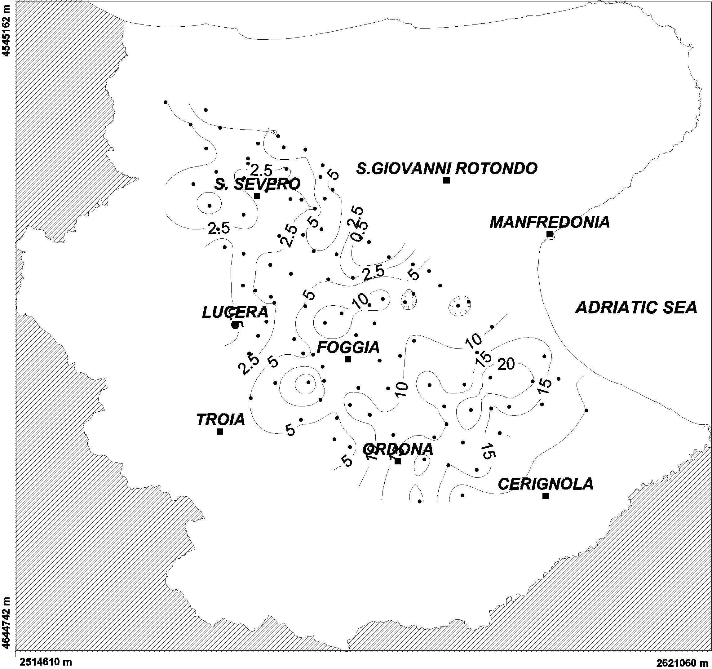
Figure 2. Piezometric decrease of Tavoliere from 1987 to 2001-2002 (m).
|
Hydrogeological unit and number of wells |
Data
from to |
CA as minimum |
Trend more probable at 2003 | |
|
Tavoliere (12) |
1929 |
1994 |
-0,034 |
High Decrease |
|
Gargano (4) |
1975 |
1978 |
-0,0026 |
Low decrease? |
|
Murgia (30) |
1965 |
2003 |
-0,020 |
High decrease |
|
Salento (17) |
1965 |
2003 |
-0,010 |
Decrease |
Table 1. Piezometric trend and data availability for each hydrogeological unit (CA as m/month).
|
Well |
SY |
AC |
VAR-CA |
|
14 |
1965 |
-0,0020 |
-44 |
|
26 |
1973 |
-0,0018 |
-318 |
|
27 |
1973 |
-0,0089 |
-202 |
|
29 |
1973 |
-0,0027 |
-32 |
|
30 |
1973 |
-0,0035 |
-315 |
|
31 |
1978 |
-0,0026 |
-178 |
|
32 |
1973 |
-0,0075 |
-827 |
|
33 |
1973 |
-0,0038 |
-118 |
|
34 |
1973 |
-0,0100 |
-785 |
|
35 |
1973 |
-0,0087 |
-252 |
|
36 |
1973 |
-0,0092 |
-91 |
|
38 |
1973 |
-0,0025 |
19 |
|
39 |
1975 |
-0,0050 |
-233 |
|
41 |
1973 |
-0,0007 |
28 |
|
42 |
1965 |
-0,0002 |
-210 |
|
43 |
1968 |
-0,0030 |
-161 |
|
44 |
1973 |
-0,0060 |
-24 |
|
46 |
1973 |
-0,0046 |
-108 |
Table 2 - Piezometric
trend at 2003 for available time series. (SY) Starting year of measurement,
(AC) AC as m/month and (VAR-CA) trend percentage variation respect to 1997.
Once said model has been established, simple
salinity data can be used to assess the trends of the effects of saltwater
intrusion over space and time. The method presented in this paper is a method
based on the plotting and comparison of trends, using geostatistical methods,
of the so-called RISC, the Reference Isoline of Salt Concentration (as TDS)
equal to 0.5 g/l, over several
time horizons, in a case study of the years 1981 and 2003, for which sufficient
data are available. Less recent data and the processing of that data were taken
from the Regional Water Rehabilitation Plan (P.R.A. – Piano Regional di
Risanamento delle Acque) of the Apulia Region (1981). The 2003 data were
collected on its own behalf by the CNR IRPI, by means of a specific survey and
sampling campaign of selected wells making up the monitoring network of the
Apulia Region, which at the time was managed by the Agency for the Irrigation
and Land Transformation of Apulia, Lucania and Irpinia (Ente per lo Sviluppo
dell’Irrigazione e la
Trasformazione Fondiaria
in
Figure 3 shows the 0.5 g/l isoline trends as referred to the year 2003, and those areas where the isoline shown has either risen or dropped as compared to the coastline, and as compared to the previous isoline position (1981). It can be thus inferred that in the former type of area, the effects of saline pollution due to saltwater intrusion has worsened the quality of the groundwater and that in the latter type of area, the effects ceased to exist.
The worsening of the quality degradation due to saltwater intrusion is, generally speaking, due to two separate causes, which often overlap. Given a specific geological and structural situation, the geometry of which is essentially stationary and which provides the necessary conditions under which saltwater intrusion can occur, there are in addition to this the effects due to the fact that water has been increasingly drawn over the past twenty years (Cotecchia & Polemio, 1997) and due to the effects of long-lasting periods of drought (Polemio & Casarano, 2004), which is the direct cause of the drop in the piezometric levels due to the decrease of the natural recharge, and is also the indirect cause of the further increase in groundwater tapping. It seems there is no real solution to this latter problem, given the lack of surface resources, distributed via the aqueducts, during periods of drought; this is the effect of long-lasting initiative for the sustainable management of the water resources. All these above-described elements overlap and create an enormous withdrawal from the top of groundwater, draining groundwater up, where the fresh water lies and where the permeable portions of the wells tap out also salt water coming from further below. The effect is also that the transition zone is raised further.
A study of the changes which have occurred in the 2003-1981 period shows a shrinking of the reference isoline, with small, very minor exceptions over the entire Murgia plain area and above all in the area found between Brindisi and Taranto, known as the Messapic threshold (Cotecchia et al., 2004). The Salentine peninsula, on the other hand, shows a clear-cut improvement in terms of saline content, except for small areas along the Ionian coastline. The drought which occurred between 2000 and the first half of 2002, which was the most serious drought in 80 years (Polemio & Casarano, 2004) has, once again, affected underground water resources, reducing availability and worsening the quality.
It is of some interest to note that over extended areas along the Adriatic coast and Ionian coast, contamination due to saltwater intrusion into groundwater which, in this case, causes the salinity levels to rise well above the reference values, is a qualitative situation which is, to a great extent, irreversible or, to be precise, is a situation which in all likelihood will remain stationary. In other words, there is a continuous coastline area, whose size can vary over the area concerned, where the salinity exceeds 0.5 g/l and has done so from 1981 to today, irrespective of the range of weather conditions responsible of groundwater recharge (Polemio & Casarano 2004), irrespective of the amount of groundwater discharged and irrespective of the change in surrounding conditions which cause saltwater intrusion. These are areas whose susceptibility to saltwater intrusion is extremely high.
Conversely, there is a large area inside the Murgia region and a small area – almost an island – in the central part of the Salentine peninsula, which has not suffered from saltwater intrusion, or at least is not at the moment suffering from saltwater intrusion and has not done so since 1981. These parts of the aquifer can be considered at low or null susceptibility to saltwater intrusion.
There is a sizeable area between these two zones of either constant absence of saltwater intrusion or of constant presence of saltwater intrusion, which is subject to fluctuations, as is clearly shown by the reference isoline of 0.5 g/l, which has shifted enormously towards the coast or towards the hinterland over the course of the four survey periods.
1 isoalina del 2003, 2 arretramento rispetto a quelle del 1981, 3 avanzamento rispetto a quella del 1981
4 Conclusions
The characterization of piezometric trend in the latest 30 years highlights a remarkable lowering and a widespread quantity degradation of groundwater resources in each considered aquifer.
These effects are more relevant in some inner portions of Tavoliere and Murgia. The piezometric lowering in Salento is slower but extremely risky due to the natural low piezometric level above sea level which is a characteristic of this hydrogeological unit. In this case low piezometric lowering can cause high increase of salt pollution risk due to seawater intrusion.
The lasting memory effect shows by each considered hydrogeological unit can reduce and delay but it is not able to remove completely the negative effects of long drought periods.
The whole set of results indicate a progressive impoverishment of high quality Apulian groundwater. The sustainable use of this resources should be started as soon as possible, considering these as a basis to reduce the effect of droughts periods.
The sizeable variability in salt concentration over time and over space, and the overall general increase in salinity over the course of the last twenty years have shown that the risk of a decrease in the quality of water due to saltwater intrusion of the underground water resources of the Murgia area and the Salentine hydrogeological structures must not be underestimated.
The main cause of the increased degree of salinity is that water use is not carefully planned and not subject to sustainable management of underground water resources. Goundwater resources are currently substantially overexploited to meet an uncontrolled and ever-increasing demand for water and this is not sustainable over the long term. An analysis of the findings shows a very high and serious risk of saltwater intrusion into the underground water system, particularly in the Salentine peninsula.
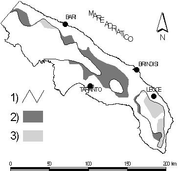
Figure 3. Changes occurred to 0.5 g/l isoline referred to 2003-1989 period; 1) 0.5 g/l isoline of year 2003, 2) risen as compared to the previous isoline position (1989), 3) dropped as compared to the previous isoline position (1989).
References
[1] Regione Puglia (1983) - Piano di risanamento delle acque. BUR n.132/83, L.R. del 19/12/83 n. 24, Bari.
[2] Regione Puglia (2002) - Piano Direttore a stralcio del piano di tutela delle acque. Commissario delegato per l'emergenza ambientale, Sogesid s.p.a., Bari.
[3] Cotecchia V. (1977) - Studi e ricerche sulle acque sotterranee e sull'intrusione marina in Puglia (Penisola Salentina). Quad. Ist. Ric. Acque, Rome, XX, 345 p.
[4] Lopez A., Maggiore M., Masciale R., Massari R., Passerella G. & Vurro M. (2003) - Caratteri idrogeologici del Tavoliere di Puglia e stato ambientale della falda superficiale nell'area compresa tra il F. Fortore e il T. Cervaro. C.N.R. - I.R.S.A., Rapporto Interno, Bari.
[5] Polemio M. (2000) - Degradation risk owing to contamination and overdraft for Apulian groundwater resources (Southern Italy). Water resources management in a vulnerable environment for sustainable development, UNESCO-IHP, Grifo Publishers, Perugia, pp. 185-194.
[6] Polemio M.& Casarano D. (2004) - Rainfall and drought in southern
[7] Polemio M. & Dragone V. (2004) - La siccità e la disponibilità di acque sotterranee in Puglia. Accademia dei Lincei n. 204, “La siccità in Italia”, 187-193.