


Achievements
CONSTRUCTION OF SPATIAL DATABASE FOR GROUNDWATER RESOURCE IN CHINA1
Liang Guoling, Zhang Yongbo, Zhang Lizhong, Zhou Xiaoyuan, Zhang Chunying
(Institute of Hydrogeology and Environmental Geology, CAGS,
[1][1] Part of study results for the Project "New Round All-China Groundwater Resource Assessment"(K5.4, Project code 0299209078), Land and Resources Investigation Project.
E-mail: Lguoling_iheg@163.com
Abstract: The database of groundwater resource in
Key words: database, map layer, data gathering
The groundwater
resource is the important factor for ensuring the water supply for the people
and supporting the social economic development. To further investigate and
assess the groundwater resource status in
1 Structure Designing of Groundwater Resource Database
In order to correctly describe the outline of all-China groundwater resource data and reflect the features of groundwater resource data, overall and systematical analysis to the data structure of groundwater resource should be made and standard data model of groundwater resource should be set up before gathering all-China groundwater resource data and designing the spatial database.
1.1 Data analysis
All-China groundwater resource database is map-based spatial database, which not only covers spatial vector data, but also is in possession of graph attribute feature, these enrich the content of the map. The data mainly contains groundwater resource investigation and comprehensive assessment information, of which the content can be divided into: groundwater resource zonation, groundwater resource distribution, groundwater resource exploitation and utilization, groundwater chemistry, groundwater environment. The groundwater resource zonation is managed by the administrative division and groundwater system zonation; The groundwater resource distribution mainly describes the groundwater resource spatial distribution status and distribution characteristics; The groundwater exploitation and utilization reflect groundwater resource exploitation, exploitation potential and groundwater water supply status in main cities; The groundwater chemistry and groundwater environment describe groundwater chemical features, groundwater quality assessment, aquifer vulnerability analysis and the various environmental problems caused by the groundwater exploitation.
1.2 Data structure designing
Based on the analyzing the data and information concerning all-China groundwater resource investigation and assessment and in combination with the clients' demand, the data and information will be divided into five categories and each categories will further divided as Fig.1, thus, the structure model and interrelation of the groundwater resource data and information will be established.
2 Groundwater Resource Database Standard
The all-China groundwater resource database involves many types of data and is comparatively complicated. In order to realize the orderly and standardization management and ensure the smooth establishment of the database, when the unified standard for establishing the database is made out, the existing state standards or professional standards should be closed with. Generally the spatial database construction standard formulated by the China Geological Survey should be cited.
2.1 Spatial database map layer denomination and division standard
The spatial
database is the data integration that the spatial data and information will be
represented in the digitalized form. The map layer is the integration of same
feature of geographic substance in the certain spatial extent. The map layer in
the groundwater resource database of
|
Groundwater resource zonation |
Hydrogeologic zonation | |
|
Groundwater resource administrative zonation |
Groundwater resource zonation (province, autonomous region and municipality) Groundwater resource zonation (district ) Groundwater resource zonation (county) | |
|
Groundwater resource natural zonation |
Fig. 1 Groundwater resource data structure of
|
Groundwater resource distribution |
Groundwater resource quantity |
Groundwater resource modulus Groundwater exploitable resources modulus Groundwater resource in main cities Exploitable storage of deep confined groundwater Spring (thermal spring, subterranean river) flow amount at various times Groundwater
resource quantity of each province in the southern Groundwater
resource quantity of each region in the southern Outcropped rock karst water runoff modulus in the southern karst area |
|
Groundwater type | ||
|
Groundwater resource spatial distribution |
Saline groundwater distribution area Perennial frozen soil distribution area Hidden karst distribution area Special rocks groundwater resource distribution area Karst spring area Big karst spring |
Fig. 1 Groundwater resources data structure of
|
Groundwater resource exploitation and utilization |
Groundwater resource exploitation in main cities Groundwater resource exploitation degree Groundwater resource exploitation and utilization status and potential analysis Groundwater exploitation and utilization status in main cities Groundwater
resource exploitation of each province in the Groundwater resource exploitation of each province in southern karst areas Groundwater ratio in water supply in main cities Groundwater ratio in household water supply in main cities Groundwater ratio in water supply for industry in main cities Groundwater ratio in water supply for agriculture in main cities Groundwater source sites Deep confined groundwater distribution area with the exploitation prospect |
Fig. 1 Groundwater resource data structure of
|
Groundwater chemistry |
Salt content in groundwater and its main chemical types Main cities with higher total hardness of groundwater Typical mineral spring sites Important groundwater source protection sites Main sediment basin distribution area Groundwater isotherm distribution |
Fig. 1 Groundwater resources data structure of
|
Groundwater environment |
Groundwater quality grade Groundwater vulnerability zonation Groundwater environmental background distribution Groundwater environmental background distribution sites Groundwater pollution component Groundwater pollution Ground collapse Ground collapse frequently-occurring areas Regional groundwater water table decline extent Groundwater cone of depression Seawater intrusion Land subsidence Ground fissure Salinized soil Salinized soil reclamation area Desertification Rockification Intense soil erosion area Endemic disease investigation Wetland in 1980s Pollution accident investigation |
Fig. 1 Groundwater resource data structure of
The map layer denomination can be divided into three categories: type code, professional recognition code and map layer order code. The map layer name is composed of seven codes. The first two are type code, then the following three are professional recognition code and the last two are map layer order code (Table 1).
Table 1 Comparison of type code and profession code
|
Provincial area |
Code |
Provincial area |
Code |
All-China, region |
Code |
|
|
11 |
|
41 |
All-China |
A0 |
|
|
12 |
|
42 |
Yangtze River Delta |
B1 |
|
|
13 |
|
43 |
|
B2 |
|
|
14 |
|
44 |
Huang-Huai-Hai Plain |
B3 |
|
Inner Mongolia |
15 |
Guangxi |
45 |
Karst area in the south of |
B4 |
|
|
21 |
|
51 |
Sanjiang Plain |
B5 |
|
|
22 |
|
52 |
Songliao Plain |
B6 |
|
|
23 |
|
53 |
Arid area in Northwest China |
B7 |
|
|
31 |
|
54 |
Profession code comparison | |
|
|
32 |
|
61 | ||
|
|
33 |
|
62 |
Profession |
Code |
|
Anhu |
34 |
|
63 |
Groundwater resource |
DZY |
|
|
35 |
Ningxia |
64 |
Groundwater resource exploitation and utilization |
DKF |
|
|
36 |
Xinjiang |
65 |
Groundwater chemistry |
DHX |
|
Shadong |
37 |
|
71 |
Groundwater environment |
DHJ |
To correctly and rationally divide the map layer is the key step for the database construction, and professional content classification of data is the important basis of the data lamination, so not only the feature and characteristics of the data should be taken into consideration, but also the overall structure of the database should be taken into consideration. All the data with regards to the professional characteristics should be classified in unity and the map layer division plan should be determined based on the established structure model and relation of groundwater resource data (Table 2).
Table 2 Map layer division, denomination and corresponding attribute table of database
of the
groundwater resource in
|
No. |
Map layer division |
Name |
Type |
Attribute table name |
Attribute table type |
|
1 |
Hydrogeological zonation |
##DZY01 |
Plane |
Hydrogeological zonation |
Internal |
|
2 |
Groundwater resource natural zonation |
##DZY02 |
Plane |
Groundwater resource zonation basic condition table Zonation groundwater resource summary table window Zonation groundwater resource quantity of different times Zonation groundwater resource exploitation of different times The ratio of zonation various recharge in total recharge resources quantity |
Outer attachment |
|
3 |
Groundwater resource province (city) zonation |
##DZY03 |
Plane |
Groundwater resource quantity of province (autonomous region and city) |
Internal |
|
4 |
Groundwater resource site (city)zonation |
##DZY04 |
Plane |
Basic conditions of district (city) Future groundwater guarantee degree analysis Groundwater exploitation and remaining quantity investigation |
Outer attachment |
|
5 |
Groundwater resource zonation (county) |
##DZY05 |
Plane |
Basic conditions of zonation (county) Groundwater resource allocation (county) Groundwater exploitation and utilization investigation Groundwater exploitation degree (county) |
Outer attachment |
|
6 |
Groundwater resource modulus |
##DZY06 |
Plane |
Groundwater resource modulus |
Internal |
|
7 |
Groundwater exploitable resource modulus |
##DZY07 |
Plane |
Groundwater exploitable resource modulus |
Internal |
|
8 |
Groundwater type |
##DZY08 |
Plane |
Groundwater type |
Internal |
|
9 |
Groundwater resource quantity in main cities |
##DZY09 |
Plane |
Groundwater resource quantity in main cities |
Internal |
|
10 |
Exploitable storage of deep confined groundwater |
##DZY10 |
Plane |
Exploitable storage of deep confined groundwater |
Internal |
|
11 |
Spring (thermal spring, subterranean river) flow amount at various times |
##DZY11 |
Plane |
Spring (thermal spring, subterranean river) flow amount at various times |
Internal |
|
12 |
Groundwater resource quantity of each province in
the southern |
##DZY12 |
Plane |
Groundwater resource quantity of each province in
the southern |
Internal |
|
13 |
Groundwater resource quantity of each region in
the southern |
##DZY13 |
Plane |
Groundwater resource quantity of each region in
the southern |
Internal |
|
14 |
Outcropped rock karst water runoff modulus in the southern karst area |
##DZY14 |
Plane |
Outcropped rock karst water runoff modulus in the southern karst area |
Internal |
Table 2 (continued) Map layer division, denomination and corresponding attribute
table of
database of the Groundwater resources in
|
No. |
Map layer division |
Name |
Type |
Attribute table name |
Attribute table type |
|
15 |
Saline groundwater area |
##DZY15 |
Plane |
Saline groundwater area |
Internal |
|
16 |
Deep confined area |
##DZY16 |
Plane |
Deep confined area |
Internal |
|
17 |
Perennial frozen soil area |
##DZY17 |
Plane |
Perennial frozen soil area |
Internal |
|
18 |
Hidden karst area |
##DZY18 |
Plane |
Hidden karst area |
Internal |
|
19 |
Groundwater resource in special rocks |
##DZY19 |
Plane |
Groundwater resource in special rocks |
Internal |
|
20 |
Karst spring area |
##DZY20 |
Plane |
No attribute table | |
|
21 |
Karst spring |
##DZY21 |
point |
No attribute table | |
|
22 |
Groundwater resource exploitation in main cities |
##DKF01 |
point |
Groundwater resource exploitation in main cities |
Internal |
|
23 |
Groundwater resource exploitation degree |
##DKF02 |
Plane |
Groundwater resources exploitation degree |
Internal |
|
24 |
Groundwater resource exploitation and utilization status and potential analysis |
##DKF03 |
Plane |
Groundwater resource exploitation and utilization status and potential analysis |
Internal |
|
25 |
Groundwater exploitation and utilization status in main cities |
##DKF04 |
point |
Groundwater exploitation and utilization status in main cities |
Internal |
|
26 |
Groundwater resource exploitation of each
province in the |
##DKF05 |
Plane |
Groundwater resource exploitation of each
province in the |
Internal |
|
27 |
Groundwater resource exploitation of each province in southern karst areas |
##DKF06 |
Plane |
Groundwater resource exploitation of each province in southern karst areas |
Internal |
|
28 |
Groundwater ratio in water supply in main cities |
##DKF07 |
point |
Groundwater ratio in water supply in main cities |
Internal |
|
29 |
Groundwater ratio in household water supply in main cities |
##DKF08 |
point |
Groundwater ratio in household water supply in main cities |
Internal |
|
30 |
Groundwater ratio in water supply for industry in main cities |
##DKF09 |
point |
Groundwater ratio in water supply for industry in main cities |
Internal |
|
31 |
Groundwater ratio in water supply for agriculture in main cities |
##DKF10 |
point |
Groundwater ratio in water supply for agriculture in main cities |
Internal |
|
32 |
Groundwater source site |
##DKF11 |
point |
Groundwater source site |
Internal |
|
33 |
Deep confined groundwater distribution area with the exploitation prospect |
##DKF12 |
Plane |
Deep confined groundwater distribution area with the exploitation prospect |
Internal |
|
34 |
Exploitation depth of deep confined groundwater |
##DKF13 |
Plane |
Exploitation depth of deep confined groundwater |
Internal |
|
35 |
Salt content in groundwater and its main chemical types |
##DHX01 |
Plane |
Salt content in groundwater and its main chemical types |
Internal |
|
36 |
Main cities with higher hardness of groundwater |
##DHX02 |
point |
Main cities with higher hardness of groundwater |
Internal |
|
37 |
Typical mineral water site |
##DHX03 |
point |
Typical mineral water site |
Internal |
|
38 |
Important groundwater resource protection site |
##DHX04 |
point |
No | |
|
39 |
Main sediment basin distribution area |
##DHX05 |
Plane |
No | |
|
40 |
Groundwater isotherm distribution |
##DHX06 |
line |
Groundwater isotherm distribution |
Internal |
|
41 |
Groundwater quality grade |
##DHJ01 |
Plane |
Groundwater quality grade |
Internal |
|
42 |
Groundwater vulnerability zonation |
##DHJ02 |
Plane |
Groundwater vulnerability zonation |
Internal |
|
43 |
Groundwater environmental background distribution |
##DHJ03 |
Plane |
Groundwater environmental background distribution |
Internal |
|
44 |
Groundwater environmental background distribution site |
##DHJ04 |
point |
Groundwater environmental background distribution site |
Internal |
|
45 |
Groundwater pollution component |
##DHJ05 |
point |
Groundwater pollution component |
Internal |
|
46 |
Groundwater pollution |
##DHJ06 |
point |
Groundwater pollution |
Internal |
|
47 |
Ground collapse |
##DHJ07 |
Plane |
Ground collapse |
Internal |
|
48 |
Ground collapse frequently- occurring area |
##DHJ08 |
Plane |
No attribute table | |
|
49 |
Regional depression extent of groundwater level |
##DHJ09 |
Plane |
Regional depression extent of groundwater level |
Internal |
|
50 |
Depression cone of groundwater |
##DHJ10 |
point |
Depression cone of groundwater |
Internal |
|
51 |
Seawater intrusion |
##DHJ11 |
Plane |
Seawater intrusion |
Internal |
|
52 |
Land subsidence |
##DHJ12 |
point |
Land subsidence |
Internal |
|
53 |
Ground fissure |
##DHJ13 |
line |
Ground fissure |
Internal |
|
54 |
Sinalized soil |
##DHJ14 |
Plane |
Sinalized soil |
Internal |
|
55 |
Ssalinazed soil reclamation area |
##DHJ15 |
Plane |
No attribute table | |
|
56 |
desertification |
##DHJ16 |
Plane |
desertification |
Internal |
|
57 |
rockification |
##DHJ17 |
Plane |
No attribute table | |
|
58 |
Intense soil erosion area |
##DHJ18 |
Plane |
No attribute table | |
|
59 |
Wetland in 1980s |
##DHJ19 |
Plane |
No attribute table | |
|
60 |
Endemic disease investigation |
##DHJ20 |
Plane |
Endemic disease investigation |
Internal |
|
61 |
Pollution accident investigation |
##DHJ21 |
point |
Pollution accident investigation |
Internal |
Notes: ## is the type code.
2.2 Map unit coding system
The map unit is the basic unit of the map layer, and the map unit coding is the only sign of the map unit and the key word linking the map unit and the attribute. The map unit coding should also follow a certain coding rules to link correctly with the attribute, showing its real meaning. The map unit is composed of eight digits, the first two is the type code to represent whole country, big regions or provinces, the following three digits are map layer recognition codes, composed of spelling letter representing the map layer, the last three digits are order code, order coding by the natural range.
2.3 Spatial database attribute table designing
The attribute is the reflection of the spatial substance, the map unit attribute table further describes the internal features (including quality feature, quantity feature and relation feature) of the map unit and is represented in the two-dimensional form. In the attribute table designing, feature of the spatial data should be taken into full consideration and the attributes of all kinds should be correctly analyzed and defined so that the attribute structure accurately reflects data feature of substance and avoids data verbosity so as to meet the requirements of clients and make the attribute table structure rationalization and standardization. With this end in view, the corresponding attribute tables of all map layers in the all-China groundwater resource database and its standard structure have been compiled according to the professional features based the comprehensive analysis to the data. The map unit attribute can be divided into two types: internal attribute, namely, map unit and attribute is the one-to-one relation and outer attachment attribute, namely, one map layer at same time is corresponding to a few attributes and is related to the attribute with map unit code, realizing that one map unit can be corresponding to a few attributes.
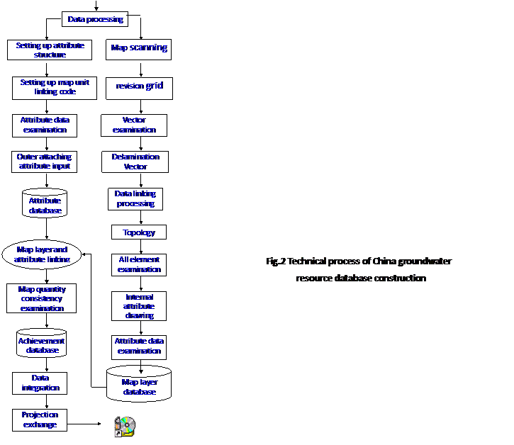
3 Technical Procedure of Groundwater Resource Database Construction
To make out
the spatial database construction technical procedure is the important step for
restraining the input and edition process of the database to ensure the
database construction quality. The technical procedure runs through the whole
process of the database construction, which can be divided into five stages:
Database construction preparation and data preprocessing![]() graphic data gathering and processing
graphic data gathering and processing![]() attribute
data gathering and processing
attribute
data gathering and processing![]() digital mapping
digital mapping![]() data integration (Fig. 2).
data integration (Fig. 2).
3.1 Graphic data gathering and processing
The important factor affecting the gathering quality and precision of the graphic data is the set-down of the gathering data standard, thus, in the data gathering process, the database construction standard must be implemented strictly as follows:
(1)The scanning vector should be taken during the graphic data gathering with the precision of color scanning over 150DPI and black and white scanning over 300DPI.
(2)The graphic vector will be carried out in the alternation form, the point element has been gathered from its geometrical center and the linear element is gathered by way of central line tracking bedding vector. The element gathering of the map is completely inosculating with the scanning data.
(3)The digitalized projection pattern of the graph is consistency with that of the corresponding base map.
(4)The graphic data gathering should be taken by layer, the graphic element can not be missed or input in repetition. When one map layer needs the content of another map layer, the copy should be made instead of input again. So the digitalized input of the map layer must follow strict order.
(5)in the process of graphic vector, the error correction must be made because there is the error between the graph and theoretical value.
(6)To make the topology processing layer by layer according to the division of the map layer in the construction of the database and to avoid the occurrence of incorrect suspending joint, false joints and suspending arch section so as to the revision of the topology relation between map layers. A correct topology relation is the basis and precondition for graphic operation and calculation.
(7)To ensure the correctness of professional map layer and geographic base map layer.
3.2 Attribute data gathering and processing
The attribute data can be classified into two types, one is graphic based internal attribute, which co-existing with the graphic data and are stored in the MAPGIS format; another are external attribute, which can be existing independently and are stored in the ACCESS format and realizes the linking of map layer and attribute. The following principles should be observed in the attribute data gathering:
To strictly follow the database attribute structure standard to input the internal attribute and outer attachment attribute data of the map unit of each map layer.
To make the examination to the all input attribute data to guarantee the correctness of the data to the database and the consistency of the graphic data and attribute data.
To fill in the data file to explain the source and reliability of the data when finishing each graphic data and attribute data gathering.
3.3 Digital mapping
The digital mapping is a main content of present
database construction, and is also one of the representation of the research
results. The digital mapping should also follow the standardization, thus, the
digital mapping in the construction of the
3.4 Database integration
(1)Spatial data and non-spatial data integration
Based on the spatial database (graphical database) and non-spatial database (pure attribute database), to link the two databases through the key word of map unit code and make the consistency examination of map unit and attribute, thus, finishing the construction of the database.
(2) Projection transformation and data format
Because the data are involved with extensive area (all-China, seven big regions and thirty-two provinces, autonomous regions and municipalities) and the map scales are different, so the projection parameters are different. With the regards to the actual conditions, all achievements data are projected according to the geographic base map of the actual map. The graphic data are the MAPGIS format and the attribute data are the format.
(3) Database and management application software integration
To construct a database management application system at the same time with the database construction, and to finish the integration of the database and database management application software so as to form the complete the China groundwater resource database system which will be burned to the disc for realizing the systematic and scientific management to the groundwater resource data and providing the service for the data browse, inquiry and output of the inquiry results.
4 Spatial Database Quality Control
The accuracy and reliability of a better spatial database system is very important, so it is required that the perfect data quality controlling system should be established in the process of the database construction to ensure the correctness of the data. The measures should be taken as follows:
(1) To establish the perfect working log, the operator must write the working log according to the requirements, including working process, working method and problems encountered. The records should be underwritten by the superattendant.
(2) To establish the complete self-examination table, each operator should carefully examine the map after finishing the work and write down the self-examination and correction results which are finally signed by the superattendant. Based on the self-examination, the project leader arranges other people to examine again with the examination ratio no less than 60%, and then write down the self-examination and correction records, which are finally signed by the superattendant.
(3) To make stage data examination, namely, to make the strict examination to the important achievements of each database construction stage, such as map element examination of map scanning vector, the examination of map unit and element after the attribute input, veracity examination of map layer matching, and the topology consistency examination.
(4) To organize the specially-assigned person to make the sample examination with the ratio no less than 10%, these not up to the quality requirements should be done again or amended so as to ensure the examination content completely according with the quality requirements.
(5) To make the quality check to the map, namely, the check to the output all essential color maps, to make the proper treatment in time on finding the pretermission or repetition for the guarantee of the data correctness.
5 Conlcusion
With the rapid development and application of information technique nowadays, the digitalization achievements with the database as the representative have become the part of comprehensive achievements in the national land and resources investigation. The data is the basis of the study and the scientific and systematical management of data for the better service to the society is the important task in the future.
Database setup
preparation
References:
[1] Zhang Zonghu, Li Lierong et al., Groundwater
Resource in
[2] Zhang Yongbo et al., Groundwater Resource in
[3] Zhang Lizhong, Zhang Yongbo, Liang Guoling et al.,
The Browser Designing and Development for Assessment Achievements of
Groundwater Resource in