Achievements
PROTECTION OF DRINKING-WATER RESOURCES IN THE UNIONBREWERY WATER BODY (LJUBLJANA, SLOVENIA)
1. Geological Survey of Slovenia, Dimiceva ul. 14, SI-1000 Ljubljana, Slovenia; tel. ++386 1 2809700, fax ++386 12809753; branka.trcek@geo-zs.si
2. Geosi d.o.o. Geological Institute, Kebetova 24, SI-1000 Ljubljana, Slovenia, tel. ++386 1 4301606; fax ++386 1 2302442; geosi@siol.net
Abstract: A study of groundwater flow and solute transport commenced in the area of the Union Brewery water body with the intention of a) assessing and predicting the movement of groundwater and urban contaminants through the unsaturated or/and saturated zone of the Pleistocene gravel aquifer and of b) analysing the risk of contaminat transport to drinkingwater resources in the lower Pleistocene gravel aquifer. The monitoring was conducted in numerous piezometers as well as at the lysimeter, which has been constructed to control the impacts of industry and traffic on the gravel aquifer. The physico-chemical and isotopic properties of sampled groundwater have produced general information on the hydrodynamic functioning of the study area. Two important flow types were identified - lateral and vertical flow. The former has an important role in groundwater protection, while the latter is the main influence on contaminant transport towards the aquifer saturated zone.
Key words: Urban area, drinking-water resources, Pleistocene alluvial gravel aquifer, groundwater flow and solute transport, sustainable management.
1 Introduction
Groundwater from a Pleistocene alluvial gravel aquifer is an increasingly important drinking-water resource for the Ljubljana area (
The lower gravel aquifer is bounded by an impermeablebarrier from the upper gravel aquifer, which is, however, contaminated by the inorganic, organic and microbial pollution. Fortunately, this contaminated groundwater does not influence the present brewery production wells, owing to their successful reconstruction during the last decade. In order to protect the brewery drinking-water resources from pollution an extensive study of groundwater flow and solute transport commenced in the area of the Union Brewery water body with the intention of a) assessing and predicting the movement of groundwater and urban contaminants through the unsaturated
or/and saturated zone of the Pleistocene gravel aquifer and of b) analysing the risk of contaminat transport to drinking-water resources in the lower Pleistocene gravel aquifer.
Flow and solute transport monitoring was conducted in numerous piezometers within the brewery and in its vicinity (some of them are illustrated in Fig. 1), as well as at the lysimeter (Fig. 1). The main goal of the piezometric monitoring is to investigate groundwater quality, whereas the main goal of the lysimeter monitoring is to study possible contamination in the vicinity of the brewery and with that to evaluate the role of the unsaturated zone in protection of groundwater from the Pleistocene alluvial gravel aquifer.
2 Description of the Study Area
The study area is an urban aquifer in Ljubljana city, located in central Slovenia. The city region is a tectonic depression, filled by up to 120 m of Pleistocene and Holocene fluvial and lacustrine sediments (Jamnik et al., 2001). They are deposited on a basement of Palaeozoic clastites. The urban aquifer consists of Pleistocene alluvial sediments that are formed of sandy and silty, locally clayey gravels (gravels are partly transformed to conglomerates), intercalated with clay layers. The overlying Holocene sediments consist of fluvial fan and silty lacustrine sediments that are generally covered by peat and clay. The Pleistocene alluvial gravel aquifer is divided into two aquifers - the lower and upper gravel aquifer that are bounded by an impermeable barrier.
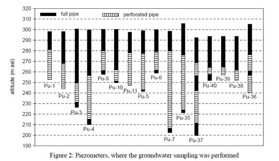
The monitoring of flow and solute transport processes was established in the saturated and unsaturated zone of the observed aquifer. The monitoring of the saturated zone of the aquifer (the lower and upper one) was conducted in 20 observation wells, located inside of a research polygon that is divided into three zones: zone I - the brewery area, zone II - the brewery vicinity and zone III - the brewery catchment area (Fig. 1). Zone I includes ten piezometers (Pu-1, Pu-2, Pu-3, Pu-4, Pu-8, Pu-9, Pu-10, Pu-11, Pu-41 and Pu-42), zone II includes three piezometers (Pu-5, Pu-6 and Pu-7) and zone III contains seven piezometers (Pu-35, Pu-36, Pu-37, Pu-38, Pu-39, Pu-40 and Pu-43).
Most of observation wells are presented in Fig. 2. They capture a) groundwater of the lower gravel aquifer, b) groundwater of the upper gravel aquifer or c) both of them.
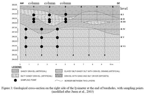
The monitoring of the unsaturated zone of the Pleistocene alluvial gravel aquifer was performed at the urban lysimeter (Juren et al., 2003), adjacent to the brewery (zone II), in 21 boreholes that are distributed at depths of 0.3-4.0 m. The boreholes penetrate four layers: sandy gravel, silt-sandy gravel, clayey silt-sandy silt with gravel grains and gravel with sand and silt (Fig. 3).
A total of 18 observation points were established on right side of the lysimeter, under the industrial railway tracks: RI-1 to RI-3, RII-1 to RII-3 and RIII-1 to RIII-3 (Fig. 3), whereas on left side of the lysimeter, beneath the asphalt surface, only 3 observation points were established: LI-4, LII-5 and LIII-6.
3 Methods and Techniques
The methodological concept of the research is designed on a multi-parametric approach (Trček, 2003; Trcek & Juren 2004, 2005) that bases on hydrodynamic parameters, on the groundwater inorganic, organic and microbial composition and on the groundwater oxygen and hydrogen isotopic composition and. Information obtained by each studied parameter completes each other and provides an insight into the flow and solute transport processes in the water body.
Piezometers of zones I and II were equipped with registrars for continuous measurements of groundwater level, its specific electroconductivity (EC) and temperature (T). In other observation wells these parameters were controlled manually once per month, during groundwater sampling. At the lysimeter the water balance of sampling points and physico-chemical water parameters (pH and EC) were measured weekly to monthly.
During the first research phase the study of solute/contaminant transport based on analysis of chlorides, heavy metals, herbicides and 18O, 2H and 3H isotopes in groundwaters. At the lysimeter groundwater was sampled with suction cups installed at the end of the boreholes. In addition, quantity and quality of precipitation were monitored near the entrance to the lysimeter, as well as of 4 surface waters - Ljubljanica river, Sava river, Mali Graben stream and Cekin spring in brewery adjacent hill Šišenski hrib (Fig. 1).
Sampling was performed
monthly, as a rule. The analisis were made by laboratory of Pivovarna Union
d.d., Acme Analytical Laboratories Ltd., Laboratory of JP Vodovodkanalazicaija
d.o.o. and Laboratory of GSF -
4 Results and Discussion
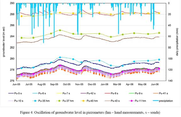
In most of observation wells groundwater level varied between 276 and 280 m asl, except in Pu-37 and Pu-40, which are influenced by the Ljubljansko barje moor, and Pu-8 and Pu-43, which should be recharged from hanging aquifers (Fig. 4). The lowest values were registered in June 2005 and January 2006, while the highest values were measured in September and November 2005, after intensive precipitation periods (Fig. 4).
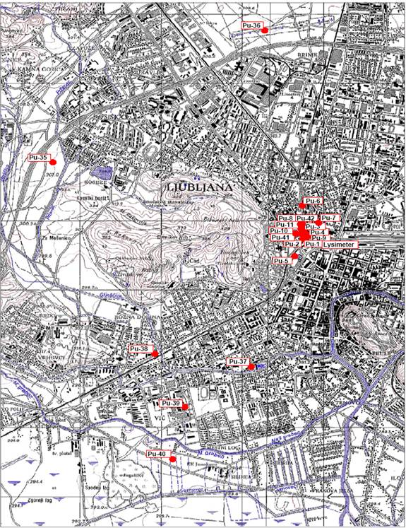
Figure 1: Research polygon (Pu-x: piezometer)
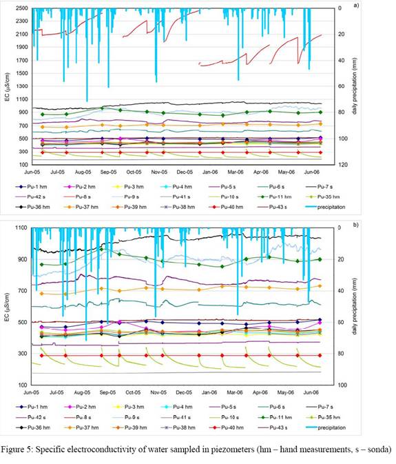
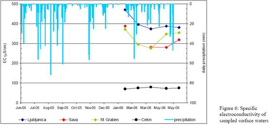
Data of EC measurements in piezometers and surface waters could be compared in Figures 5a, 5b and 6. The highest values were registered in the hanging aquifer, at Pu-8 (up to 1000 μS/cm). High values (600-1000 μS/cm), which reflect contamination, were identified also at Pu-7, Pu-9, Pu-11, Pu-42 and Pu-6 that should be recharged from the upper gravel aquifer. ThData of EC measurements in piezometers and surface waters could be compared in Figures 5a, 5b and 6. The highest values were registered in the hanging aquifer, at Pu-8 (up to 1000 μS/cm). High values (600-1000 μS/cm), which reflect contamination, were identified also at Pu-7, Pu-9, Pu-11, Pu-42 and Pu-6 that should be recharged from the upper gravel aquifer. The lowest values (150-350 μS/cm) refer to Pu-5, Pu-10 and Pu-41, which are most probably influenced by surface waters of the hill Šišenski hrib, where the Cekin spring was sampled (Fig. 6). The EC values of the remaining piezometers range between 400 and 500 μS/cm. Most of these observation wells are recharged from the lower gravel aquifer and EC data indicate a little contamination load.
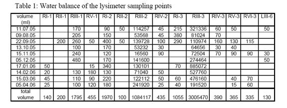
The water balance for the lysimeter sampling points is presented in Table 1. It can be observed in the table that sampling points RIII-2 and RIII-3 discharged the highest volumes, and that on both, the right and left side of the lysimeter, the bulk of water was discharged to sampling points on level III. It is important to note that a low discharge occurs under the asphalt surface (LIII-6, since none of the other sampling points yield any drainage water at that period).
Figure 3 illustrates that the sampling points on level III are located near the contact between two structurally different layers: silt-sandy gravel and underlying clayey silt-sandy silt with gravel grains. The hydraulic conductivity of the upper layer is higher than that of the lower layer. Therefore it is presumed that the greater volumes discharged from level III result from the development of a lateral flow component. On the other hand Figure 7b, which illustrates the EC data of sampled water, indicates the occurrence of vertical flow from the level III into lysimeter lower levels (coincidence of data of lower levels with data of level III).
The characteristics of specific electroconductivity of water of lysimeter sampling points are presented in Figures 7a and 7b. On the right side of the lysimeter the
parameter ranges from 180 to 550 μS/cm. Significantly higher values were measured on the left side of the lysimeter - up to 2500 μS/cm (Fig. 7a). This most probably result from winter contamination. The lowest EC values are connected with levels I and II, whereas the highest values are connected with level III (Fig. 7b), which reflects the important role of the lateral flow component near this level.
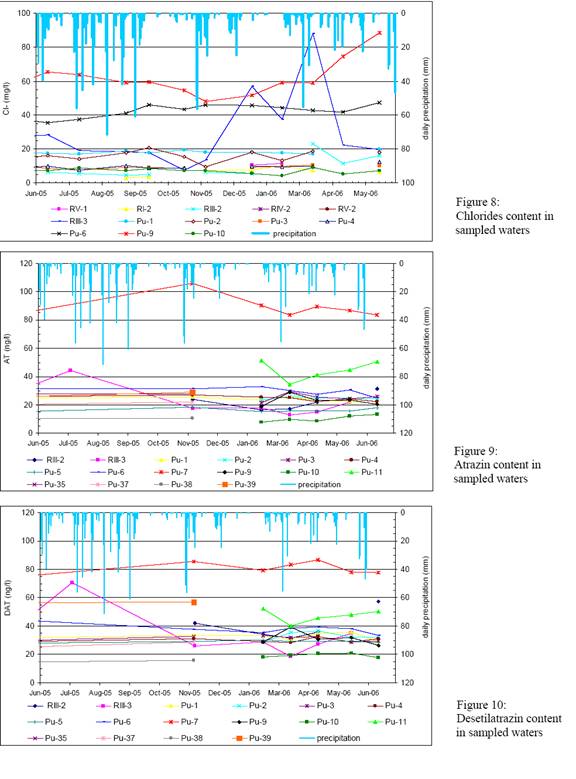
Time-trend plot of chlorides content in sampled waters is presented in Figure 8. The highest values refer to piezometers Pu-9 and Pu-6 and to the lysimeter sampling point RIII-3. They were measured in spring 2006, after the snow melt.
The results of herbicides analysis demonstrated that atrazin (AT) and its decomposition product desetilatrazin (DAT) are the most significant contaminants in the research area. The AT and DAT data of sampled waters are illustrated in Figures 9 and 10. Most of waters are little and middle load with contamination, except those of piezometers Pu-7 and Pu-11 and of lysimeter sampling point RIII-3. Table 2 presents the mass ratio DAT/AT. It is important to notice low values of the ratio that are bold. They indicate fresh or less decomposed atrazin. This is particularly characteristic for piezometers Pu-7 and Pu-11. In other locations the bold values point out the breakthrough of water from higher aquifer levels during important hydrological events, such as in March 06 (after the snow melt) in Pu-3.

5 Conclusions
The monitoring results have already produced general information on the hydrodynamic functioning of the study area and on solute transport - the main flow components, the flow hierarchy and the environmental response to the flow system have been indicated. Two important flow types were identified - lateral and vertical flow. It could be concluded that the results of the first phase of the research have produced general information on the hydrodynamic functioning of the study area and on solute transport. Synthesis of one-year of monitoring data has revealed the basic characteristics of flow and solute/contaminant transport, since the main flow components, the flow hierarchy and the environmental response to the flow system are all indicated. Two important flow types were identified - lateral and the vertical flow. Lateral flow has an important role in the protection of groundwater from the Pleistocene alluvial gravel aquifer. However, the rapid vertical recharge is the principal concern for the supplier, because it is the main factor for the contaminant transport and extension from the unsaturated zone to the saturated zone of the aquifer. The presented investigations have indicated when a groundwater abstraction in the Union Brewery is prone to this problem. The upgraded research methodology and the long-term monitoring will provide information on the distribution and frequency of the rapid recharge, which will help us to assess and improve sustainability of the brewery groundwater resources. Data of the first research phase indicated that the same monitoring should continue also in the second one, which will enable processing and modeling of data with the help of computer tools. They gave also the base for planning the tracing test conductance in the saturated and unsaturated zone of the observed water body.

Acknowledgement
The authors would like to acknowledge Union brewery, Slovenian research agency, the European commission under the fifth framework program and the Competence network "Water resources and their management GmbH (Knet Water)" for the financial support of the researches.
References
[1]
Juren A, Pregl M & Veselič M (2003) Project of an urban lysimeter at
the Union brewery,
[2]
Jamnik B, Refsgaard A, Janža M & Kristensen M (2001) Water resources
management model for
[3]
Trček B (2003) Epikarst zone and the karst aquifer behaviour, a case study
of the Hubelj catchment,
[4]
Trček B & Juren A (2004) Flow and solute transport monitoring at an
urban lysimeter of Union brewery,
[5]
Trček B & Juren A (2005) Hydrogeological investigations at an urban
area of Union Brewery,
[6]
Trček B & Juren A (2005) Hydro-geochemical investigations at an urban
lysimeter of Union brewery,


