


Achievements
RESEARCH ON THE RELATIONSHIPS BETWEEN ECO-DEPTH OF THE WATER TABLE AND ECOLOGICAL WATER REQUIREMENT IN IRRIGATION AREA OF NORTHWESTERN CHINA
Cui Ya-li1, Shao Jing-li1, Wang Xiong-fei2, Zhao Jing1
1 School of Water Resources and Environment, China University of Geosciences, Beijing 100083,China
2 China National Oversea Engineering Corporation(COVEC), Beijing 100044,China
Abstract:The relationships between eco-depth of the water table and ecological water requirement in irrigation area of northwestern
Key Words: Eco-Depth of Water Table; Ecological Water Requirement; Limit Depth of Water Table; Irrigation Area
Eco-environment is very weak in the interior
Thus it can be seen that there are close relationships among water table, soil moisture and ecological water requirement of vegetation. In order to meet the ecological water requirement, we can change the soil moisture ratio by adjusting and controlling groundwater table in a certain range or combine the surface water such as irrigation with groundwater. The purpose of this paper is to build relationships between water table depth and ecological water requirement after research on relationships among groundwater, soil moisture and ecological water requirement, and then provide important scientific calculation bases for preventing soil salinization and desertification in arid regions.
1 Groundwater Ecological Index
Since Soviet Russian agrologist B.B Bolarof(1931) set up the concept of Critical Depth of Groundwater, many scholars have done a lot of studies on the laws of soil moisture and salt’s movement among the vertical sections and the adjusting methods, with emphasis on soil moisture and salt’s movement, the laws between groundwater table depth and ecological water requirement, groundwater eco-environment index’s establishment and so on.
Water table depth is the major influencing factor to vegetation’s growth and soil moisture. In 1992,Peter J. Thourburn [1] described the relationships between evaporation quantity of soil moisture and water table depth applying the theory of stream under steady conditions, and took soil moisture content-soil moisture evaporation-groundwater table depth as the groundwater eco-environment index. In 1999, S.A.Prathapar et al[2] set up the irrigation waning influence model, in which they regarded the groundwater table depth (about
Jonathan L.Horton et al [7] have studied the plants’ physiological reflections under different groundwater table depths, and presented the threshold of groundwater table depth for plants’ physiological functions such as photosynthesis. Ali [8] has simulated the relationship between groundwater table depth and soil salinization, and regarded that the degree of soil salinization lies on soil’s physical characteristics, groundwater table depth and the roots’ depths which groundwater influences.
Through researches on relationships between groundwater, soil moisture and vegetation status in Tarim river basin, Fan Zili et al [9] have connected the groundwater table depth with eco-environment conditions, and divided groundwater table into such five types as swamp water table, salinization water table, proper ecological water table, plant menace water table and desertification water table, and determined the corresponding depths. According to the relationships between phreatic evaporation and soil salinization and desertification, the proper ecological water table depth is 2 to
In a word, many scholars all regard vegetation as the eco-environment’s pointer, and have studied the critical thresholds of indexes such as soil moisture content, soil salinity, water table depth, phreatic water mineralization etc during plants’ different growing status by field tests and investigations, and obtained a lot of results in the aspect of setting up indexes. But the same concept has different meanings due to scholars’ different understanding. So there is still a lot of study work to be done in groundwater eco-environment index field.
2 Groundwater Ecological Safety Index
Ecological safety is the carrier and foundation for a country or region [11]. It is a complex problem containing many factors, and has both broad and narrow senses [12]. In this paper it indicates the natural or semi-natural ecological system’s safety, and it is the reflection of ecological system’s integrity and health. Ecological safety of groundwater is mainly pointed to the reasonable utilization and positive recharge of groundwater resources and ecological system service, avoiding short-term or long-term disadvantageous influences to social life and production resulted from natural resources crocking up, resource productivity declining, eco-environment being polluted and degenerating. It is described by Groundwater Ecological Table Index in detail, and it’s the groundwater table that meets the eco-environment’s requirement and won’t make it degenerate. It is made up of a series of groundwater tables that meet the eco-environment’s requirement, and is the groundwater table zone required by maintaining the regional ecological system. It has different meanings in different regions.
From the groundwater ecological safety point of view and based on summing up and analyzing predecessors’ results, this paper ascertains groundwater ecological safety indexes as Eco-Depth of Water Table, Critical Depth of Water Table and Limit Depth of Water Table, which are the three most important ecological indexes for phreatic water in arid and semiarid areas.
2.1 Critical depth of water table
Critical Depth of Water Table is differently stated by different scholars [13] [14], and there is not yet a uniform definition up to the present. Despite of different definitions for this concept, they have the common ground that it’s the minimum groundwater table depth not bringing soil salinization and not endangering crops’ growing. Critical Depth of Water Table in this paper means the upper limit depth of water table that will not lead topsoil’s salinization, which is influenced by soil texture, climate conditions, phreatic water mineralization, irrigation and drainage conditions and agriculture technology measures (farming, fertilization and so on) etc.
2.2 Limit depth of water table
Limit Depth of Water Table is the lower limit depth of water table that will not bring topsoil’s desertification, which is related to soil texture, limit capillary rising height, vegetation’s roots and climate conditions etc. When the water table depth is small, the upper soil can be recharged by rising capillary water, which makes it be of high soil moisture content. As the water table declines, the recharge from capillary water that the upper soil can get becomes less, which makes the soil moisture content go down. And if the water table depth continues descending, and to the degree that even the arbors and shrubberies with deep roots cannot absorb enough water from soil to maintain their survival, the land vegetation will decay. So we can regard that the phreatic water under Limit Depth of Water Table has no actual meaning for ecological water requirement, and its influence to the topsoil can also be ignored in fact, which actually equals to the situation that the topsoil moisture content descends to the wilting coefficient.
2.3 Eco-Depth of water table
When the water table depth is upper than a certain depth, vegetation’s water requirement can be entirely provided by the phreatic water. The lower limit depth of water table that can entirely provide vegetation ecological water requirement is called Eco-Depth of Water Table. Eco-Depth of Water Table is lower than Critical Depth of Water Table but upper than Limit Depth of Water Table. Different soil texture has different Eco-Depth of Water Table. Different crop type has different ecological water requirement, and the same crop needs different water content during different growing periods, so Eco-Depth of Water Table is a dynamic value rather than a fixed value. The Eco-Depth of Water Table of natural vegetation is generally larger than it of crop due to their different roots’ depths.
2.4 Ecological water requirement
Ecological Water Requirement is referred to the water quantity required to maintain or improve eco-environment quality and keep it not to degenerate further [15]. According to the ecological system’s classification, ecological water requirement in arid and semiarid regions can be sorted into Ecological Water Requirement of Artificial Oasis, Ecological Water Requirement of Natural Oasis and Ecological Water Requirement of Desert Vegetation. In the Artificial Oasis area, Ecological Water Requirement of crop is the demanded water quantity that meets the requirements of agricultural production such as high yield, and it is briefly called Crop Water Requirement, which refers to the sum water quantity required by plant transpiration, soil evaporation and plants themselves when the crops produce high yield after normally growing up under the conditions of proper soil moisture content and fertility.
3 Relationships between Water Table Depth and Ecological Water Requirement
There are many studies on relationships between water table depth and ecological water requirement of the natural oasis, but there are few studies on relationships between water table depth and ecological water requirement of the artificial oasis. At present, there are flux method [16] [17] [18], experiential formula method and soil-water potential method used to calculate evapotranspiration of phreatic water. But the above-mentioned methods have the common problem that they cannot well reflect the factors such as crop types and their own physiology characteristics etc. Some of them even haven’t thought about the crop identities, or can’t calculate water table depth, or can’t meet the requirements of comprehensively considering all correlative factors, or can’t establish the quantified relationships between ecological water requirement and water table depth. So based on thinking comprehensively about phreatic water, soil, crop’s physiology characteristics and so on, this paper studies the quantified relationships between water table depth and ecological water requirement, with soil moisture as the medium factor.
3.1 Laws of water table depth and soil moisture content
Affected by molecule adsorbability of soil particles and water surface tension, water above the phreatic surface is mainly in the forms of hygroscopic moisture, film moisture and suspended moisture, and moisture supporting forces are primarily adsorbability between particles and water molecules and affinity between water molecules. When the adsorbability of water molecules balances the ascending water’s gravity, the following equation exists [19]:
 (1)
(1)
Where, rw-thickness of water film, L-sum of profile perimeters of all particles on the cross section, Sc-sum of interspace areas on the cross section, η-constant, h-thickness of the zone above the capillaries, Wm-gravity of capillary water which is equal to water surface tension, ρ-water density, and g-acceleration of gravity.
Make differential then integral to equation (1). As we know the molecule adsorbability of the surface soil particles equals to water surface tension, and the surface soil moisture content θa usually can be expressed as θa=rfL/Sc. On the other hand, due to the superposition of the soil surface and the top of capillary zone, θa=β(β means Field Capacity). So based on the above-mentioned, we can get the following equation for calculating the thickness of the zone above the capillaries:
 (2)
(2)
The water table depth equals to sum of the thicknesses of the capillary and its above zones, i.e. H=hc+h, then we can get the following equation to calculate the water table depth H using the surface soil moisture content:

 (3)
(3)
Where, H-actual water table depth(cm), β-soil field capacity, θa-average moisture content of the surface soil, and hc-thickness of the capillary zone(cm).
3.2 Limit depth of water table
Theoretically speaking, as long as the phreatic water exists, it must influence the surface soil moisture content. But when the water table depth is very large, the influence of the phreatic water to the surface soil actually can be ignored. In fact it means that the surface soil moisture content has declined to the wilting coefficient and the phreatic water has no effective meaning to the ecological water requirement. So the Limit Depth of Water Table can be calculated by the following equation:
 (4)
(4)
Where, hmax-Limit Depth of Water Table (cm),and the other symbols mean the same as the above.
Equation (4) can be used to calculate the Limit Depth of Water Table where there is no vegetation covering the soil surface.
3.3 Theory deducing of capillary zone’s thickness
Thickness of the capillary zone lies on water surface tension, gravity and soil physical property. Thousands upon thousands of pores in various shapes in soil are connected with each other and make up of the anfractuous capillary net system. Its thickness is mainly decided by the factors of soil porosity e, particle’s size d, soil sphericity Kc, water density and so on [19]. Average thickness of the capillary zone can be expressed by the following equation:
 (5)
(5)
3.4 Relationships between ecological water requirement and soil moisture content in case of water shortage
Total evapotranspiration of crop is expressed by the function of weather condition, soil moisture and crop’s biological characteristics under the condition of water shortage. Weather’s influence to total evapotranspiration of crop can be presented by total evapotranspiration of reference crop (ET0), and crop’s biological characteristics can be reflected by crop coefficient (Kc). So we can get the following [15] [20]:
 (6)
(6)
f2(s) is mainly related to soil moisture. Researches show that total evapotranspiration of crop is only related to soil’s available moisture. But the available moisture of various soil has great difference, so it’s better to express f2(s) as the function of relative available moisture content (θa-θwp)/(β-θwp). When actual soil moisture content θa is less than β, total evapotranspiration of crop is distinctly affected by soil moisture, otherwise it isn’t influenced so distinctly by soil moisture. Research results show that, f2(s) can be expressed as the exponential function of soil relative available moisture content:

 (7)
(7)
Where c and d are the experiential coefficients determined by measured data, which vary with the changes of crop’s growing phrases and soil conditions.
The relationship between total evapotranspiration of crop and its influencing factors can be expressed as the following:

 (8)
(8)
Where, ETa-actual ecological water requirement of crop or vegetation (mm), which can be obtained by measured data, ET0-total evapotranspiration of reference crop (mm), which can be calculated by Penman Formula [21], Kc-reference crop coefficient, and θwp-soil wilting moisture content.
4 Researches on Laws of Eco-Depth of Water Table and Ecological Water Requirement
Based on the above contents, when θa<β, we can combine equations (8) and (3). Considering the root’s thickness of crop or vegetation, the following equation can be derived:
 (9)
(9)
Where, Hec-Eco-Depth of Water Table(cm), C1=1/(β-θwp)3, C2=θw/(β-θwp), Kc=aLAI+b, in which a and b are experiential coefficients determined by measured data with the regression method and vary with crop types,
 -the experiential coefficient determined by measured data, which varies with crop’s growing phrases and soil conditions, and hr-the root’s thickness of crop or vegetation (cm).
In equation (9), Hec means calculated eco-depth of water table, that is to say, it’s the lower limit of water table depth that meets the actual ecological water requirement without irrigation. The actual ecological water requirement below Hec must be additionally recharged by irrigation. When water table depth declines to Limit Depth of Water Table, the actual ecological water requirement must be totally supplied by irrigation. Equation (9) is derived with consideration of the relationships between water table depth and soil moisture and the relationships between ecological water requirement and soil moisture, and it reflects the general law of water table depth and ecological water requirement.
4.2 Modification for limit depth of water table
When water supplied by phreatic water for ecological water requirement becomes zero, such a depth is Ecological Limit Depth of Phreatic Water Table, which is called Limit Depth of Water Table for short. So we can get the equation used to calculate Limit Depth of Water Table from equation (9):
 (10)
(10)
Where,  -Limit Depth of Water Table (cm), and the other symbols have the same meanings as the above.
4.3 Ecological water quantity recharged by actual water table depth
When phreatic water table is known, ecological water quantity ETu supplied by phreatic water can be calculated:

 (11)
(11)
Where, ETu-Ecological Water Quantity supplied by Phreatic Water(mm), H means Actual Water Table Depth (mm), and the other symbols have the same meanings as the above.
It’s known from the above equation that, phreatic water can supply ecological water requirement when the water table depth is less than Eco-Depth of Water Table, and phreatic water can’t supply ecological water requirement when the water table depth is larger than Limit Depth of Water Table, and phreatic water can supply part of ecological water requirement when the water table depth is between Eco-Depth of Water Table and Limit Depth of Water Table. For the same type of crop, the supplied water quantity lies mainly on water table depth.
5 Calculation for Eco-Depth of Water Table in the Plain at the North Foot of Tianshan, XinJiang
Adopting the above-mentioned equations, Eco-Depths of Water Table of several crops (cotton, corn and winter wheat) in several different soil textures are calculated, with the field monitoring data of Changji-Shihezi region provided by Changji test station, XinJiang Geology and Mine Bureau (see table 1). The roots’ thicknesses of cotton, corn and winter wheat are evaluated as
Table 1 Calculation of Eco-Depth of Water Table
Type | Crop Category | ETa (mm) | ET0 (mm) | Kc | β (%) | θwp (%) | hc (cm) | hr (cm) | Hec (cm) | Hmax (m) |
Light Loam Soil | Cotton | 532.59 | 802.93 | 0.96 | 18.4 | 8.3 | 70 | 45 | 150 | 5.77 |
Corn | 519.69 | 802.94 | 0.97 | 35 | 144 | 5.67 | ||||
Winter Wheat | 540.70 | 624.30 | 1.23 | 25 | 128 | 5.57 | ||||
Medium Loam Soil | Cotton | 532.59 | 802.93 | 0.96 | 20.1 | 12.1 | 115 | 45 | 197 | 4.35 |
Corn | 519.69 | 802.94 | 0.97 | 35 | 191 | 4.25 | ||||
Winter Wheat | 540.70 | 624.30 | 1.23 | 25 | 175 | 4.15 | ||||
Clay Soil | Cotton | 532.59 | 802.93 | 0.96 | 22.3 | 17.4 | 155 | 45 | 231 | 3.61 |
Corn | 519.69 | 802.94 | 0.97 | 35 | 224 | 3.51 | ||||
Winter Wheat | 540.70 | 624.30 | 1.23 | 25 | 209 | 3.41 |
Note:ETa and ET0 are the data from XinJiang Irrigation [22].
phrases. In practice, they should take the data of every detailed growing phrase to calculate respectively. Soil textures are the several typical types (Light Loam, Medium Loam and Clay Soil) in Changji-Shihezi area.
It is known from table 1 that Eco-Depth of Water Table Hec is generally 1.3~
It can be seen from the table that, different crops in the same soil type have different Eco-Depths of Water Table, and the same crops in different soil types also have different Eco-Depths of Water Table, which
indicates that Eco-Depth of Water Table lies on the factors of soil texture, crop or vegetation type and so on. Of course the above results are obtained under the same weather condition. Eco-Depths of Water Table of the same crops in the same soil type are different under different weather conditions. So simply thinking about only one or two aspects but not the whole can’t reflect the actual situations.
The precondition for deriving the equation is that soil moisture becomes the confined term of ecological water requirement, so it is only fit to calculate the Eco-Depth of Water Table of crop or vegetation in arid and semiarid areas, and it can’t be used in areas under other weather conditions, such as in humid areas where the soil moisture content is usually larger than or equal to Field Capacity.
6 Application
Apply the above calculated results to researches on reasonable exploitation and utilization of groundwater resources in Manasi river drainage area at the north foot of Tianshan in XinJiang. According to the relative positions of actual water table depth and Eco-Depth of Water Table in Manasi river drainage area, we divide the arid area into several ecological regions. Based on the actual water table depth during the dry season in June 2000, the Manasi river drainage area can be divided into three ecological regions (see figure 1).
Ecological region Ⅰ
It’s the region where the water table depth is less than Eco-Depth of Water Table (Water table depth is less than
Ecological region Ⅱ
It is the region where the water table depth is between Eco-Depth of Water Table and Limit Depth of Water Table (The water table depth is 3
Ecological region Ⅲ
It is the region where the water table depth is larger than Limit Depth of Water Table (The water table depth is larger than
Conclusions
Eco-Depth of Water Table provides a suitable lower limit for the water table depth, above which phreatic water can totally meet the ecological water requirement. It is the basis for reasonable exploitation and utilization of groundwater resources (phreaic water) in arid areas, the important premise for adjusting and controlling eco-environment to develop well, and also the techniques of sustainable water resources management. So it has very important actual significance to make researches on Eco-Depth of Water Table. The study on ecological regions in Manasi river drainage area is based on the ranges of the actual water table depth, reference Eco-Depth of Water Table and Limit Depth of Water Table. It reflects the distribution characteristics of groundwater table and ecological water requirement of crop. These ecological regions provide the basis for determining the modes of reasonable exploitation and utilization of groundwater and dividing water resources subareas.
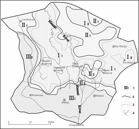
Figure 1 Ecological Regions in
Legend: 1. Ecological Region Number;2.Region Borderline;3.Sub-region Borderline;4.River
References
[1] Peter J.Thourburn. Comparison of diffuse discharge from shallow water tables in soils and salt flats [J]. Journal of Hydrology, 1992, 136:253-274.
[2] S.A.Prathapar, A.S.Qureshi. Modeling the effects of deficit irrigation on soil salinity, depth to water table transpiration in semi-aid zone with Monsoonal rains [J]. Water Resources Development, 1999, 15(1/2):141-159.
[3] Cui Yali, Shao Jingli. Ecological Environment Adjustment by Groundwater in
[4] Song Yudong, Fan Zili, Lei Zhidong et al. Research on Water Resources and Ecology of
[5] Guo Zhanrong, Liu Huatai. Secondary Salinification of Soil and Dynamic Control of Groundwater in Irrigation Area of Inland Basin, Northwestern China [J]. Agro-environmental Protection, 2002, 21(1):45-48.
[6] Wang Hao, Chen Minjian, Qin Dayong. Studies on Rational Allocation and Carrying Capacity of Water Resources in
[7] Jonathan L.Horton. Physiological response to groundwater depth varies among species and with river flow regulation [J]. Ecological Applications, 2001, 11(4): 1046-1059.
[8] Ali, R., R.L. Elliott, and J.E. Ayars, et al. Soil salinity modeling over shallow water tables.Ⅱ: Application of LEACHC [J]. Journal of Irrigation and Drainage Engineering. 2000, 126(4): 234-242.
[9] Fan Zili, Ma Yingjie, Zhang Hong et al. Research of Eco-water Table and Rational Depth of Groundwater of Tarim River Drainage Basin [J]. Arid Land Geography, 2004,27(1): 8-13.
[10] Zhang Li, Dong Zengchuan, Xu Jianxin. Natural Stand and Its Water Requirement in Lower Reach of
[11] Xiao Duning, Chen Wenbo, Guo Fuliang. Discussion on Basic Concepts and Study Contents of Ecological Safety [J]. Chinese Journal of Applied Ecology, 2002, 13(3):354-358.
[12] Chen Dongjing, Xu Zhongmin. Study on Assessment of the Ecological Security in the Continental Watersheds in Northwest China—A Case Study at the Middle Reaches of Heihe River Watershed, Zhangye Prefecture [J]. Arid Land Geography, 2002, 25(3):219-224.
[13] Guo Zhanrong, Liu Huatai, Xing Enchun. Study on the Transformation Relationship between Phreatic Water and Soil Moisture in the
[14] Zhang Huichang. Ecological Balance Depth of Groundwater in Arid Area [J]. Site Investigation Science and Technology, 1992, (6):9-13.
[15] Kang Shaozhong. Research on Theory of Water Transport in Soil-Plant-Atmosphere Continuum and Its Application [M]. Beijing: China Waterpower Press,1994.
[16] Xu Yuexian. Study on Agricultural Water Utilization Efficiency [M].
[17] Cheng Guodong. Study on the Sustainable Development in
[18] Hu Anyan, Zhou Jinlong, He Yi et al. A Study on Unsaturated Soil Transmissibility in Arid Area [J]. Agricultural Research in the Arid Areas, 2002, 20(2):65-67.
[19] Deng Ruru. Analysis of
[20] Kang Shaozhong. Agricultural Water Saving and Sustainable Utilization of Water Resources in North-western
[21] Rui Xiaofang. Physical Hydrology [M].
[22] XinJiang Water Resources Department. XinJiang Irrigation [M]. Urumqi: XinJiang People’s Press, 1993.