


Achievements
QUALITY OF GROUNDWATER OF THE MIDDLE- AMUR ARTESIAN BASIN
Sergey A. Kozlov
Far East State Regional Center of Geomonitoring, 20-b,
Abstract:Peculiarities of the Middle-Amur artesian basin ground-water formation were revealed after investigation of various natural and human related factors. Ground waters in natural environment conditions and those used for water supplies were probed. As a result, the so-called hydro-geochemical provinces characterized by a higher concentration of Fe, Mn, Si, Ba, and Li where established within the artesian basin boundaries. Importance of ground water as a source of water for large human settlements instead of polluted water of
Key words: Hydro-geochemical provinces, Amur, artesian basin, ground-water, Fe, Mn.
The Middle-Amur artesian basin (Fig. 1) is located at the middle and downstream of
The Middle-Amur basin is characterized by a regional ground-water flow. An overall thickness of deposits which form the basin is up to
The total amount of ground water reserves of the Amur valley is estimated to be
Artesian water formation is affected by a climate, geological structure, hydro-dynamical and geo-morphological and other factors. Simultaneous influence of these factors is resulted in a quite complicated pattern of iron distribution in the ground water. Distinctive features of the Middle-Amur basin's ground water chemical composition formation is oxigen free environment and a relatively high content of Fe and Mn in water bearing rocks. The amount of Fe in ground waters is increasing from basin boundaries towards its center reaching 20-30 mg/l (80 mg/l at some places). In accordance to that process transition from hydro-carbonate sodium waters at the basin boundaries through hydro-carbonate magnesium-sodium waters to hydro-carbonate calcium-iron waters at the center occurs.
Vertical zoning exits in Fe and Mn concentration dependence from the ground water depth. The Middle-Amur basin artesian water contains dissolved oxygen, carbon dioxide, and nitrogen only at depths less than 10
Figures 2-3 below show examples of the vertical hydro-geochemical profile for two large groundwater deposits of the basin: Tunguss deposit near city of
Basin's environment is favourable for formation of higher concentration of iron and manganese as well as some other elements. Territories where ground waters have locally higher (relative to the Maximum Allowed Concentration) content of controlled elements are divided into hydro-geochemical provinces. Our research made possible to locate and qualitively characterize several such provinces in the Middle-Amur artesian basin. These provinces (which overlap with each other) determine main anomalies in the ground water quality. Table 1 shows provinces characterized by a higher concentration of Fe, Mn, Si, Ba, and Li in the groundwater.
Despite of problems with the ground water quality large deposits ready for industrial usage were discovered. These deposits are sufficient for daily life and industrial needs of a city with a population of more than 500 000 people. Example of such ground water deposit is Tungus deposit near city of
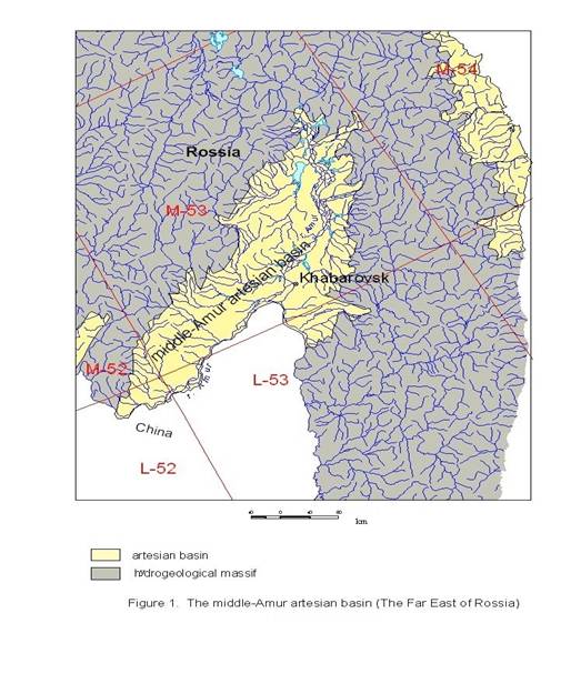
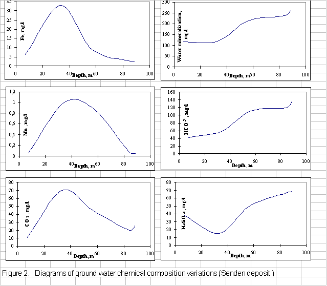

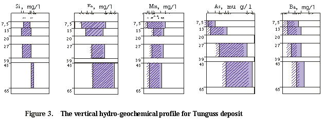
Table1 The characteristics of natural hydro-geochemical provincesof the Middle-Amur artesian basin (The Far East of
The basic aquaifer | Chemical elements present in ground water with a concentration exceeding the maximum allowed limits | Concentration, mg/l |
1. Southern part of the Middle-Amur artesian basin (On | ||
Aquaifer of pliocene-quaternary epochs (Ng2 – Q) | Fe | 1,7 - 27 |
Mn | 0,4 – 2,1 | |
Si | 10,6 – 23,9 | |
Ba | 0,1 – 0,35 | |
As | 0,005 – 0,05 | |
Li | < 0,01 – 0,04 | |
Aquaifer of eocene-miocene epochs(Pg2-3 – Ng1) | Fe | < 0,3 - 2 |
Mn | < 0,1 – 0,3 | |
Si | 11 - 38 | |
Ba | < 0,1 – 0,58 | |
Li | < 0,01 – 0,04 | |
2. Northern part of the Middle-Amur artesian basin | ||
Aquaifer of pliocene-quaternary epochs (Ng2 – Q) | Fe | 1 – 30 |
Mn | 0,5 – 2,5 | |
Si | 5 – 15 | |
Ba | 0,05 – 0,13 | |
3. Internal hidrogeological massif of the Middle-Amur artesian basin | ||
Aquaifer of paleozoic-mesozoic era in sedimentary and magmatic rocks (Pz– Mz) | Fe | < 0,3 – 2 |
Mn | < 0,1 – 1 | |
Si | < 10 – 15 | |
Ba | < 0,1 – 0,8 | |
Li | < 0,03 – 0,15 | |
4. Mountain frame of the Middle-Amur artesian basin: Central-Sihote-Alinskiy hydro-geological massif | ||
Aquaifer of quaternary epoch (Ple - Hol) | Fe | < 0,3 – 1,0 |
Mn | < 0,1 – 0,5 | |
Si | < 10 - 15 | |
Aquaifer of miocene- quaternaryepochs in volcanic rocks (Ng1 –Ple) | Fe | < 0,3 – 1,5 |
Mn | < 0,1 – 1,4 | |
Si | < 10 – 18,3 | |
Aquaifer of paleozoic-mesozoic era in sedimentary and magmatic rocks (Pz– Mz) | Fe | < 0,3 – 2 |
Mn | < 0,1 – 1 | |
Si | < 10 – 17,5 | |
Ba | < 0,1 – 0,3 | |
Li | < 0,03 – 0,29 | |