Wang Wenmin, Wang Wenke,Chen
Xuguang and Xu Min
Chang’an University
Abstract: The Northern Piedmont of Tianshan
Mountain is a primary zone of economic
development in Xinjiang
Province, in which there
is a shortage of water resources and the irrational exploitation and usage of
water resources have already caused a series of side effect to the ecological
environment. In order to utilize the regional water resources reasonably and
realize the balanced relationship between water resources and the development
of social economy and environment, it is essential to reinforce the
exploitation of groundwater resources. On the basis of the researches into the
regional hydrological and geological conditions, this article makes a
scientific evaluation of the storage and regulation capacity of groundwater
reservoirs from three aspects: the space, the supply and the project. The
researches show that presently a serious problem lies in the exploitation and
usage of water resources that the increasing rate of surface water usage and
the neglect of the storage and regulation of groundwater reservoirs. Therefore,
it is necessary to transform the ways of exploiting and using of the regional
water resources. On account of the present situation and the future plan of the
exploitation and usage of the regional water resources, it proposes a way to
make full use of storing and regulating ability of groundwater reservoirs to
increase the use of groundwater resources, which is the fundamental way to
realize the appropriate exploitation and usage of groundwater resources to meet
the needs of cities and towns on the lower reaches of the river, and at the
same time to decrease the ecological environment side effect resulted from the
overuse of the surface water. Thus, the healthy development between regional
water resources and environment can be achieved.
Key Words: groundwater reservoirs,
water resources, ecological environment, and the capacity of storage and
regulation
Introduction:
In the arid and semiarid regions, the evaporation amount is usually
several times as much as the rainfall because of the intense evaporation and
scanty precipitation. Constructing the surface reservoirs bring about not only
the waste of water resources but also a series of social and environmental
problems, such as the occupation and salinization of land. Therefore, to
construct underground reservoirs on conditioned areas is an effective
resolution to water resources on arid and semiarid regions. Rivers in the
Northern Piedmont of Tianshan
Mountain mainly depend on
the melting ice and snow for supply, so they are conspicuously seasonal. During
the dry season of spring and autumn there appear to varied degrees bottlenecks
in the Northern Piedmont of Tianshan
Mountain. Thus, we can
make full use of the storing and regulating functions of underground reservoirs
to regulate the ill-distributed water resources in different seasons and to
further realize the reasonable exploitation and usage of water resources.
Beginning with the hydrogeologic structure of this region, this article
makes evaluation of the storage capacity of groundwater reservoirs in the
Northern Piedmont of Tianshan
Mountain from three
aspects: the storing and regulating space, supplies and project. Then it
analyzes the economic, social and environmental benefits incurring by the
construction of groundwater reservoirs and finally it reaches a conclusion that
constructing groundwater reservoirs in this region will be beneficial to the
society, the economy and the environment.
1
General Regional Situation
The Northern Piedmont of Tianshan
Mountain is located in
the Eurasian interior far away from the ocean, bearing the typical arid inland
basin weather. It is very dry due to the scanty precipitation and intense
evaporation. For many years the average rainfall was only 150-200mm, but the evaporation amount 1000-4000mm. The water source in the area mainly
depends on the melting ice snowof the high mountain. There is a little rainfall
in the hilly land and plain area. All of the rivers rise in the high mountain
areas, running across the ex-mountain structure through the very profound
allucial fan and finally disappearing in the desert. The medium and high
mountain area is the formation place of water resources and the lowland hilly
structure is the runoff area and the plain the developing and vanishing area.
Therefore, the rivers originated in the Tianshan
Mountain flowing in front of it are
the primary water sources for the economic development district in the Northern
Piedmont of Tianshan
Mountain. Because of the
increasing demand, the shortage of water resources has already been a
bottleneck restricting the regional economic development. At present the
exploitation and usage of water resources are centralized in the plain area.
The water is utilized directly at the outlet. The overuse of water in the upper
reaches of rivers deprives the ecological water demand in the lower ones. The
over exploitation of water in plain areas caused a series of ecological problems,
whereas the groundwater reservoirs in the depressions of the Tianshan Mountain
are ill-exploited. As a result, the effective use of the storing and regulating
capacity of groundwater reservoirs in the depressions of the Mountain is a
valid solution to water resources problems.
The neo-tectonic movement
has formed three rows of anticline structures and east-west counter fracture[1]:
one is the anticline structure of the Northern Piedmont of Tianshan Mountain,
the second Manasi anticline structures and the third Anjihai anticline
structure. The three lines of structures shaped a string of goose-like
structure depressions in which piled up a huge ice water gravel stratum of the
Quaternary Period which became a giant groundwater reservoir. From east to west
there is the groundwater reservoir of the Chaiwobu
Basin, the one at the depression of
mountains in Manasi
River Basin, the one at
the Wowate-Anjihai depression and another one at the south Dushaizi depression.
2 The Storing and Regulating Space of the Groundwater Reservoirs
The storing and regulating space of the groundwater reservoirs is the
fundamental condition for constructing them, which must enjoy the following
characteristics: the large storing and regulating space, the immense storage
constant for aquifer, the strong permeability and transmissibility and so on.
The groundwater reservoirs at the depression in the ex-mountain structure of
the Northern Piedmont of Tianshan
Mountain have excellent
storing and regulating space, and plenty of water resources which make them
good natural groundwater reservoirs.
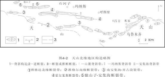
Fig.1 The schematic diagram
of the tectonic zone in the Northern Piedmont of Tianshan Mountain [2]
Chaiwobu Basin
is semi-closed, surrounded by Tianshan
Mountain in the south, Bogeda Mountain
in the north, the east side of Chaiwobu
Lake in the east and the Qianshui River region of the Xishan Farm in the
west. The Basin north-south is long and east-west narrow. Because of the
neo-tectonic movement, the Basin can be divided into three independent parts:
the Wulumuqi River
Basin, the Chaiwobu Lake Basin
and the Aspen River basin. There are piles of
unconsolidated deposits of the Quaternary Period, with the upper part pluvial
gravel stratum and the lower glaciofluvial gravel stratum. The unconsolidated
deposits have good permeability. The thickest water bearing layer can reach 800m, whereas the average is just 200-400m. the groundwater is the unconsolidated
Quaternary pore submersible. It is calculated that the biggest
storage capacity of the groundwater reservoir in the Chaiwobu Basin
is 451.5×10⁸m3/a,
the least 438.6×10⁸m3/a
and the adjustable storage capacity12.9×108m3/a[3].
Therefore, it is a superb natural groundwater reservoir and can be used to
solve the water resources problems in Wulumuqi.
The groundwater reservoirs at the depressions in the Manasi River Basin
are situated between the first and the second rows, transversing the Jinggou
River, the Ningjia River, the Manasi River and the Taxi River, among which the
altitude of the Manasi River valley is the least and the outflow region of the
groundwater reservoirs. The length of this depression is about 85km and the width 13-17km, with an area of some 1275 km2. There piles up huge
gravel and soil of the lower Pleistocene series and the medium Pleistocene
series, with the relatively unconsolidated structure, the developed pore space.
The depth of the saturation zone can reach to 380-750m, which formed a good storing space. The first
row structure, the second one and the tightly-cemented gravel of the Tertiary
system in the lower part have formed a closed basin-like east-west water
resisting border. It is calculated that the biggest storage capacity of the
groundwater reservoir at the depression of the Manasi River
is 530.4×10⁸m3 and the least 510×108m3.
The difference between the two is the adjustable storage capacity (20.4×10⁸m3),
in other words, when the groundwater level decreases 1m, it will gain the adjustable storage capacity of
2.04×10⁸m3. Therefore, the ex-mountain groundwater
reservoirs in the Manasi River, made of closed water resisting border, is one
with a huge storing and regulating space.
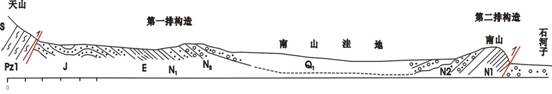
Fig.2 The north-south section sketch map of
underground reservoir in Manasi
River Basin [4]
The groundwater reservoir of the Wowate-Anjihai depressions is situated
among the ex-mountain major dislocation of the Yilinharnai Mountain,
the Dshanzi-Anjihai fracture and the anticline of the Anjihai, separated from
the Dunan depression of by the fracture zone of Wulanbulake in the west. The
east-west length of the depression is 60km and the north-south one is 6-8km with an area of some 450km2.The major water bearing
stratum consists of the sandstone and conglomerate of the upper and mid
Pleistocene series of the Quaternary Period, with an average depth of 450m and the deepest part of 600m. It is calculated that the biggest
storage capacity of the groundwater reservoir at the Wowate-Anjihai depression
is 308×108m3/a,
the least 297×108m3/a
and the adjustable one 11×108m3/a.The
lower mudstone of the Tertiary has shaped the water resisting border of the
groundwater reservoir. The groundwater reservoir in the plain region is
supplied by the depression groundwater as groundwater runoffs through the
Halaande water penetrating tube, the Anjihai valley and the sandy-bay section.
The Dunan depression is located between the Kuitun River
and the ex-mountain structural basin. Influenced by the Tertiary protrusion,
there piled up the unconsolidated sediment of the Quaternary period with the
average depth of approximately 400-600m
and the aquifer was mainly made of the Wusu cluster of the upper and
mid-Pleistocene series with the average depth of about 100m.The groundwater in the basin between the
mountains is supplied by the river leakage, the channel leakage, the
ex-mountain influent steam of the storm rainfall and flood current, the side
runoff of the bedrock mountain and the water penetration of the valley underrun
and the ex-mountain rainoff. Then it runs through the Dushanzi-Anjihai fracture
into the plain as groundwater supple. The west groundwater flows to the north,
the east river to the northeast through the Wulanbulake Chase flowing down in
the lower river, and a little amount of it flows to the north with the total
excretory amount of 0.5411×10⁸m3/a. The large scale groundwater
reservoir formed by the ex-mountain basin and the Tertiary swelling region
enjoys relatively strong storing and regulating capacity, with a storage
capacity of about 0.5×10⁸m3/a.Recently the Dushanzi
chemical plant has constructed only water supply works in the upstream of the
swell but no other exploitation. The total production volume of the groundwater
at the depression is 0.5×10⁸m3/a and still enjoys a great
latent capacity.
The groundwater reservoirs at the depression of the Northern Piedmont
of Tianshan Mountain have such characteristics: 1) The water-resisting borders,
consisting of the rock stratum of the depression basis and the round Tertiary
Miocene and Pliocene series, are relatively closed.2) The Quaternary ice water
gravel stratum piled in the depression has formed the primary water-bearing
layer.3) The storing and regulating space is large.4) The aquifer’s great
capacity for storage and its good permeability make it easy to store and
regulate the water resources. All these mentioned characteristics are extremely
excellent conditions for constructing the groundwater reservoirs.
3 The Adjustable Water Sources of the Groundwater Reservoir
Another necessary condition for constructing the groundwater reservoir
is the adjustable water sources. And the groundwater reservoir in the Northern
Piedmont of Tianshan
Mountain structure has a
great amount of adjustable water sources. The rivers rising from the alpine region of the Tianshan Mountain invert with the groundwater
frequently when running across the ex-mountain depression, providing abundant
water resources for groundwater reservoirs’ storing and regulating.
The groundwater reservoir in the Chaiwobu Basin
is mainly supplied by the leakage of the bed river and the influent steam of
the field irrigation and the precipitation. After running out the mountain, except a little amount led
directly, a great deal of the river water is provided for the groundwater because of the strong
permeating ability of the bed river on the alluvial-proluvial fan,
which is the essential nourishment source of the basin groundwater. The
groundwater is recharged by about 1.0579×10⁸m3/a of the river, channel and
field leakage and some 0.2937×10⁸m3/a[5] of
lateral groundwater. Influenced by the function of the basal constitution, the geology and
the geomorphy, the groundwater influxes from the basin environment to its
centre.
The Manasi
River Basin provides
enough water resources for the groundwater reservoir’s storing and regulating.
It is reported that the biggest yearly runoff volume of the Manasi River
reached at 14.66×10⁸m3/a, the least
10.25×10⁸m3/a
and the average 12.7×10⁸m3/a.
by the data of the Hongshanzui hydrological station. And it is the important
alimentation resource for the two groundwater reservoirs. Additionally, the Taxi River,
the Ningjia River,
the Jingou River
and other rivers along the two sides of the Manasi
River provide the ex-mountain
groundwater reservoirs with ample water resources and it accounts for 32% of
the flow amount of the Manasi
River at the Hongshanzui
mountain gap. The rich water resources in the Manasi River
secure an adequate supply for the groundwater reservoir’s storing and
regulating. According to the data of Kensiwate the biggest runoff volume of
Manasi River is 20.19×10⁸m3/a, the least 9.357×10⁸m3/a and the average 12.19×10⁸m3/a.The high water period is from June to
October, accounting for 70% of the yearly total volume, and from November to
March is the drought period. The biggest runoff volume of Taxi River is2.94×108m3/a,the least 1.93×10⁸m3/a and the average flow
amount 2.25×10⁸m3/a。The runoff of the Ningjia
River is 0.71×10⁸m3/a.Because of the
influence of the landform, the precipitation and its form are different from
the south mountain region to the north plain region at the depression of the Manasi River.
The precipitation in the mountain region is about 800mm and the primary form is snow. It is the major
resource of the region. The ex-mountain rainfall has a limited effect on the
groundwater reservoir due to its little precipitation and the yearly rainfall
if under 200mm.
Besides, the Manasi groundwater reservoir is supplied by the crake groundwater
in the south and the lateral groundwater in the east and west.
The Anjihai
River is the major supplier
for the Wowate-Anjihai depression, with a average yearly runoff of 3.8×10⁸m3/a of which 0.711×10⁸m3/a for the
depression.Besides that there is also the lateral and the rainfall
alimentation. The total alimentation of the depression is 2.2×10⁸m3/a.
The groundwater reservoir of the Nandu depression accepts the vertical
leakage of the Kuitun River, the Bayingou
River and the Wulanbulagou River
and the total leakage is about 0.7716×10⁸m3/a accounting for 11.34% of
the surface runoff, 70% of the total alimentation of the depression. Including
the rainfall leakage and the lateral leakage, the natural groundwater
alimentation at the depression is 1.2573×10⁸m3/a and the biggest
production volume is0.8173×108m3/a.
The qualified water is the major supplier for the towns and cities in the lower
river basin.
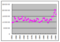
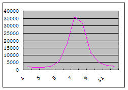
Fig.3 Yearly runoff of the Manasi
River Fig.4 Average monthly flow of
the in Kensi Walt station (1958-
2000) Manasi River in Kensi Walt Station
As an important water
supplier for the ex-mountain groundwater reservoir, rivers have abundant water
resources. The high water period is from June to September and it is good for
the groundwater reservoir’s storing and regulating. Just take Manasi River
for example, its high water period is from June to August, and the runoff
accounts for 70% of the total. Its drought period is from November to March.
4 The Project Measures for the Groundwater Reservoir
With the storing and regulating space and water sources, it is
necessary to take some project measures in order to achieve the goal.
Considering the water demand in the region, the artificial project construction
must be implemented economically, properly and safely.
Because of the closed storing and regulating space of the groundwater
reservoir in the Northern Piedmont of Tianshan Mountain,
there is no need of the water interception project. And the major projects are
the groundwater exploitation, the artificial recharge and the conveyance
project. The groundwater exploitation should be distributed all over the region
of
outflow and exploit
groundwater collectively by the exploitation well. The groundwater replenishing
project should be constructed in the area with good permeability near the
mountain. When the high water period comes the flood is intercepted in the
underground by using the percolation pit and well. And a complete relevant set
of the conveyance project must be used to deliver the groundwater to the
water-demanding region. For example, the groundwater reservoir in the
ex-mountain of the Manasi
River basin can be
exploited in the stream channel near the mountain vent and constructed the
central water supplier. The percolation pit and well are constructed at the
depression near the Tianshan
Mountain to increase the
groundwater alimentation. In doing so, the water resource can be used
effectively to solve the drought problem during the lower water period.
5 Benefit Analysis
The Northern Piedmont of Tianshan
Mountain is the major economic
development zone of the Xinjiang
Province and the water
resource is the essential element for the regional economic increase. But the
utilization of the water resource in the plain has already reached high and the
exploitation space is limited whereas the groundwater is not exploited
completely, hence the qualified water of the groundwater reservoir’s storing
and regulating resources can be delivered directly to the towns and cities in
the lower river basin. It can be used as the water supplier for the towns and
cities and also an emergency water resource. Therefore, the construction of the
groundwater reservoir in the mountain region can not only promote the
utilization ratio of the regional water resource but also solve the ecological
environment problems caused by the decline of the groundwater level. In a word,
constructing groundwater reservoir in this region is beneficial to the society
, the economy and the environment.
6 Conclusion
The conclusion can be reached after the research: The groundwater
reservoir in the ex-mountain of the Northern Piedmont of Tianshan Mountain
is a excellent natural one because of the large storing and regulating space
and the ample water resource. A certain set of artificial measures can animate
the function of the groundwater reservoir and achieve the goal of effective use
of the regional water resource, which can be beneficial to the society, the
economy and the environment.
Reference:
[1]
Xiao Chonghua, Li Peng, Li Wenpeng, Characteristics and Exploitations of
Groundwater Reservoirs in Depression Zones in the Northern Piedmont of Tianshan
Mountain, 2005.4:74-77
[2]
Qiao Xiaoying, Wang Wenke, Cnen Ying, Storage Water Structure Modes and
Water Cycle Characteristic at the Tianshan Mountain Foot, Journal of Earth Sciences
and Environment, 2005,9:33-37.
[3]
Chen Lan, Yi Haisheng, Muhetaer Zari, Effects of Neo-Tectonic Movement
on Groundwater Area in the Chaiwobu
Basin of Xinjiang.
Journal of Chen Du University
of Technology, 2002, 10:
555-560.
[4]
Li, Junting, The Evaluation of the Storing and Regulating Ability of
the Water-Bearing Strata in Front of the Manasi River Basin, 2004:1.