


Achievements
GROUNDWATER USE IN THE SELENGE RIVER BASIN, MONGOLIA
Hiller, B.T.,1,2 & Jadamba, N.1
1 Institute of Geoecology, Mongolian Academy of Sciences
2 Australian Youth
Ambassador for Development
Abstract:The Selenge River Basin occupies a total area of 447,000 km2, of which 343,000 km2 is located within Mongolia (the remainder is in Russia). The basin is characterized by an
extreme continental climate, consisting of harsh, cold, dry winters and short,
hot summers. Annual average temperatures are
approximately -4°C and annual rainfall ranges from 220mm to 450mm.
The major surface water resources in the basin include Hovsgol Lake, the Selenge, Orkhon and Tuul Rivers and the basin ultimately drains into Lake Baikal in Russia. The hydrogeology of the basin is varied and consists of a combination of
alluvial deposits, Cambrian and Precambrian limestones, granites, sedimentary deposits and metamorphic rocks.
The Selenge River Basin is a critical groundwater resource for Mongolia. Greater than 55% (~1.5 million)
of Mongolia’s population resides
within the basin and, during 2003, an estimated average of 700,000 m3/day of water was abstracted from the basin’s
groundwater system. The basin services Mongolia’s largest cities and industries (including the rapidly
expanding mining sector) as well as important traditional pastoral ranges.
Recently created hydrogeological maps, coupled with
topographical maps, have been used to identify both unconfined and confined
groundwater resources within the basin. The total area of groundwater-bearing resources within the basin is
estimated at approximately 280,000 km2, and while
the volume of the resource has not been quantified; average recharge into the
basin has been calculated at 5.6 x 10⁹ m3/yr. It is believed that approximately
5% of the total annual recharge volume feeding into the basin is being
utilized.
However, due to the great spatial extent and irregularity of groundwater
resources in the basin, coupled with the equally heterogeneous concentration of
evolving landuses, some local aquifers near major
centres are likely being overexploited, hence it is important to manage each
sub-catchment individually within a greater overall management plan. Sustainable yields need to be determined to ensure maintenance of
current groundwater levels and environmental flows for rivers, as well as
providing a sustainable resource for continued utilisation. These need to be incorporated into management strategies at the
international, regional and local level to ensure ongoing conservation of the
resource and fair access for all stakeholders.
Keywords: Selenge River Basin, Groundwater Resources, Abstraction, Competing Landuses, Water Quality, Sustainable Yield, Management Plan
Introduction
General
Mongolia is a landlocked country located
in north central Asia between Russia and China (refer to Figure 1).
Spatially, it is the 19th largest country in the world, occupying a total area of 1,564,000 km2 (NSO, 2005). It is situated on an elevated plateau (average elevation of 1,580m) surrounded by mountain ranges. Mongolia’s territory is
divided into two major geographic regions: the Khangai (including the Altai and Khangai-Khenty mountain ranges) in
the central and western regions; and the Gobi (including the Steppe and Gobidesert areas) in the southern and eastern regions (Figure 1).
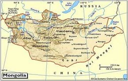
(Geosystems Global Corporation, 2006)
Figure 1 – Map of Mongolia
Mongolia experiences a harsh, continental
climate with four distinct seasons characterized by particularly dry, cold
conditions in winter and hot temperatures in summer. Annual rainfall across the country is many times below the world average
and is as low as 50mm in the Gobi desert and up to about 450mm in the northern regions. Furthermore, when
rain does fall, it is generally intense and can cause localised flooding.
The country is divided into 22 provinces (aimags) and municipalities and its capital is Ulaanbaatar city. The current population of Mongolia is approximately 2.8 million and it contains the lowest national
population density in the world (NSO, 2005). In 1990, Mongolia shifted from decades of socialist rule to a democratic government and
joined the global market economy.
Land classifications
Of a total national land area of 156,400 ha, 115,500 ha (74%) are agricultural lands, 14,700 ha (9%) are forest resources and the remainder comprises cities, villages
and other settlements, transportation and network land, state special use land
and water resources land (NSO, 2005). Land recognised for water resources purposes constitutes just 970 ha (0.6%) of total land area.
Water resources
It is estimated that the total annual water resources available for
potential use in Mongolia are 34.6 km3, of which 28.4 km3 are surface water resources and 6.2 km3 are groundwater resources (Janchivdorj, L., 2005).Of the surface water resources, there are more than 5,500
rivers, 9,600 springs, 350 mineral waters and 4,200 lakes in Mongolia (NSO,
2005).
Despite the apparent wealth of surface water resources, just 20% of
total water consumption in Mongolia comes from these surface waters, with the remaining 80% recovered from
groundwater sources (Janchivdorj, L., 2005).
Surface waters, which are frozen, or partially frozen, for many months
each year has meant that groundwater is the primary source of water supply for
major urban and industrial centres and the extensive animal husbandry
sector. Additionally, many of the major
river systems drain to areas outside of Mongolia, to ultimate destinations such as Lake Baikal and the Arctic Ocean in Russia, and hence much of this
resource is not utilised in Mongolia.
Major River Basins
There are 58 recognised International River Basins
throughout Asia (Wolf, A.T., et al., 1999) (refer to Figure 2).
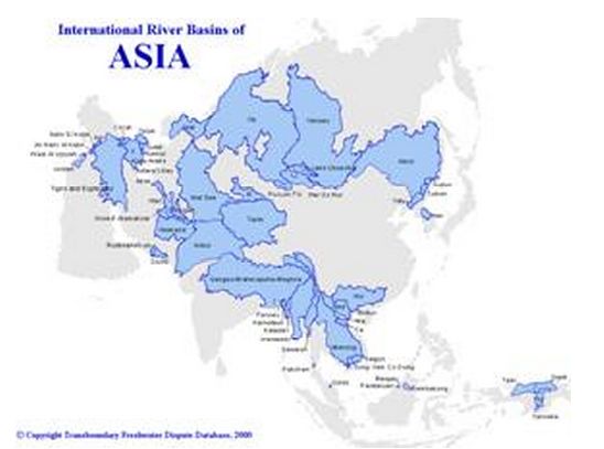
(Transboundary Freshwater Dispute Database,
2000)
Figure 2 – International River Basins in Asia
Mongolia contains three
International River Basins, namely: the Northern Arctic Ocean Basin (also known as the Yenisey River Basin), the Pacific Ocean Basin (also known as the Amur River Basin) and the Central Asian Internal Drainage Basin (collectively
including the Har Us Nur, Lake Ubsa Nur and Pu-Lun-To River Basins) (refer to Figure 3).
These basins all drain to different outlets.The Northern Arctic Ocean Basin is located in northern and central Mongolia
and drains northward through Russia and ultimately into the Arctic Ocean. This basin has an area of 2,557,800 km2,
of which approximately 13% (328,000 km2 (Wolf, A.T., et al., 1999) or 343,000 km2 (Janchivdorj, L., 2005) lies within Mongolia. The Pacific Ocean Basin is located in eastern Mongolia and drains eastward through China, Russia, North Korea and ultimately into the Pacific Ocean. The basin has an area of 2,085,900 km2, of
which 190,600 km2 (or ~9%) lies within Mongolia (Wolf, A.T., et al., 1999). Finally, the Central Asian Internal
Drainage Basin is located in western and southern Mongolia and does not have an ocean
outlet. It consists of a series of
internal drainage systems within Central Asia. Har Us Nur River Basin occupies an area of 185,300 km2 in Russia, Mongolia and China, of which the bulk (179,300
km2) lies in Mongolia (Wolf, A.T., et al., 1999). The Lake Ubsa-Nur occupies a total area
of 62,800 km2 in Mongoliaand Russia, of which 76% is located in Mongolia. The Pu-Lun-To River Basin extends 89,000 km2 across the countries of China, Mongolia, Russia and Kazakhstan, of which 11,100 km2 (~12%) lies in Mongolia (Wolf, A.T., et al., 1999).
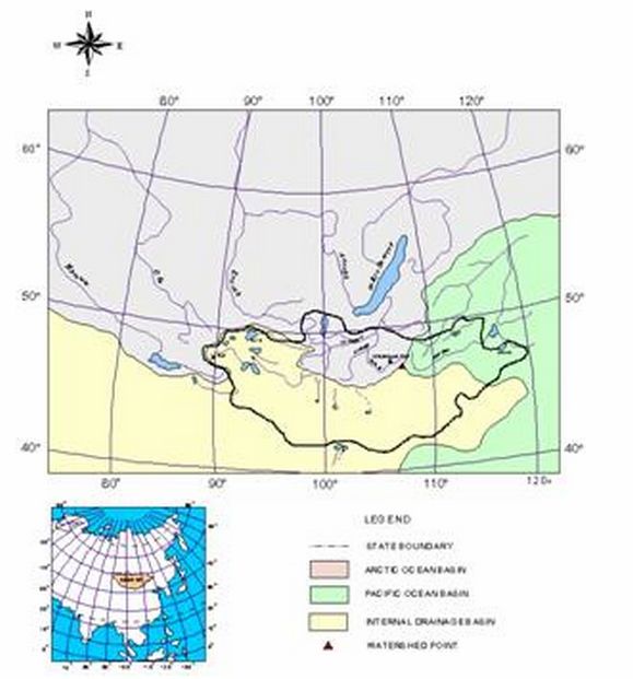
(Institute of Geoecology, 2005)
Figure 3 – International River Basins in Mongolia
The Central Asian Internal Drainage Basin occupies
the greatest area of Mongolia (68% of the national territory), however contains the smallest potential
water resources of the three basins (refer to Table 1). Much of the area of this basin is occupied by the great Gobi Desert, which receives very
little precipitation. However, both the Northern Arctic Ocean Basin (16.9 km3) and the Pacific Ocean Basin (13.9 km3) contain significant potential water
resources.
Table 1 International River Basins in Mongolia
|
Basin |
Area
ofMongolia(%) |
Water
Resources (km3) |
|
Northern
Artic Ocean |
20.5 |
16.9 |
|
Pacific
Ocean |
11.5 |
13.9 |
|
Central
Asian Internal Drainage |
68.0 |
3.8 |
|
TOTAL |
100 |
34.6 |
(Reproduced from Janchivdorj, L., 2005)
Lying within the three International River Basins
in Mongolia are six major Regional Basins. The Northern Arctic Ocean Basin contains the Selenge River Basin; the Pacific Ocean Basin contains the Kherlen and theOnon-Ulza-Khalka Basins; and the Central Asian Internal Drainage Basin contains the Great Lake, South Gobi and North Gobi Basins (refer to Table 2).
Table 2 – Regional Basins in Mongolia
|
WorldBasin |
RegionalBasin |
Popn.
(1000’s) |
Area
(km2) |
Popn.
Dens. (/km2) |
|
Northern
Arctic Ocean |
Selenge |
1,500.9 |
343.2 |
4.4 |
|
Pacific
Ocean |
Kherlen |
240.0 |
180.7 |
1.3 |
|
Onon, Ulz& Khalka |
100.0 |
150.5 |
0.6 |
|
|
Central
Asian Internal Drainage |
GreatLake |
393.7 |
288.5 |
1.3 |
|
South
Gobi |
115.5 |
343.5 |
0.3 |
|
|
North
Gobi |
143.9 |
257.7 |
0.6 |
|
|
TOTAL |
|
2,533.1* |
1546.1 |
1.6** |
* Total estimated
population for 2003
** Average
(Reproduced from Janchivdorj, L., 2005)
The regional basin with the greatest population
(1.5 million people or 59% of the national population) and the greatest
population density (4.4 people per km2) is the Selenge River Basin. This basin supports the major
urban and industrial centres, including the capital city of Ulaanbaatar, as well as the chief agricultural and mining sectors and is
a critical resource for the country.
This paper will explore the important characteristics of the Selenge River Basin and assess the sustainability of
current practices, before recommending future best management strategies.
Selenge River Basin
Geography
The Selenge River Basin extends across both Mongolia and Russia, from latitudes of N46° to N52° and longitudes of E97° to
E109°. The basin occupies a total area
of 447,000 km2, of which 343,000 km2 (76%) lies within central and
northern Mongolia (Figure 4). (For the purposes of this
paper, only the Mongolian portion of the Selenge River Basin will be considered hereon unless
stated otherwise).
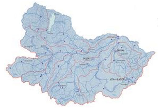
(Institute of Geoecology, 2005)
Figure 4 – Selenge River Basin, Mongolia
The basin is bound by the Russian border to the
north, the Khenty Mountains in the east, the Gobi desert in the south and the Khangy Mountains in the west. The major surface water features within the basin include the Selenge, Orkhon and Tuul Rivers and Hovsgol Lake (Figure 4). The relief across the basin ranges from 600m in the major valleys to 2500m in the mountainous zones.
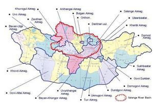
The basin extends across all, or part of, the aimags of Arkhangai, Bulgan, Orkhon, Khovsgol, Selenge, Darkhan Uul, Tov, Zavkhan and Uvurkhangai, as well as the municipality of Ulaanbaatar (refer to Figure 5). It contains the major population centres including Ulaanbaatar city and aimag centres such as Tsetserleg, Murun, Bulgan, Sukhbaatar, Zuunmod, Erdenet and Darkhan.
Climate
The basin is characterized by an extreme continental climate, consisting
of harsh, cold, dry winters and short, hot summers. The sub-climates across the basin are more specifically described as
“Humid and Cold” in the northern, western and eastern region; the central
regions are largely classified as “Semi-Humid and Semi-Cold” zones, while the
southern regions are “Semi-Dry and Cool” zones (Ministry of Water Economy et.
al., 1986).
(Adapted from
Legend Tour, 2006)
Figure 5 – Aimags of Mongolia
Although the annual average temperature in the
basin ranges from approximately -7°C (in the north) to 0°C (in the south), the average yearly maximum temperature in the basin is 40°C and the average yearly minimum
temperature is -53°C (Institute of Geoecology, 2005). Annual rainfall ranges from approximately 220mm in the south to 450mm in the northwest.
Annual evaporation (measured from surface water bodies) in the basin
ranges from less than 450mm, in the eastern, southwestern and northwestern regions, to greater
than 650mm in the northern, southeasternand central western
regions (Ministry of Water Economy et. al., 1986).
The average thickness of snow cover during the winter months (October to
April) ranges from less than 10cm in the southern regions to greater than 20cm in the western, northern and
eastern regions.
Due largely to its great distance inland, annual average air humidity in
the basin ranges from less than 60% in the western and southern regions to
greater than 70% in the central northern regions (Ministry of Water Economy et.
al., 1986).
Landscape
The most widespread land classification in the Selenge River Basin (and much of Mongolia) is “Dry Steppe”, which is located in the central part of the
basin. The “Taiga” forest region is
located in the northern areas of the basin near the border with Russia, while mountainous areas (often permanently snow covered) are
present in the western and southwestern regions near the Khangai mountain range.“Forest Steppe” and “Forest”
areas are located in the central and northern regions while wetlands are
located in the lower central and southern regions. “Desert Steppe” and “Desert” areas are located in the southern regions
near the northern edge of the infamous Gobi desert (Ministry of Water Economy et. al., 1986).
Mineral resources
The area within the Selenge River Basin contains significant confirmed, and potential, mineral resources. Minerals of significance include copper, gold, coal, iron ore, quartz
and rare metals. Copper is believed to have the
greatest potential resource base, followed by gold.
Population
The Selenge River Basin occupies only 22% of Mongolia’s total area (343,200km2),
however, it contains between 55-60% of the nation’s population (NSO,
2005). Within the aimags in the basin, population densities range from a minuscule 1.3 to a
massive 196.6 people per square kilometre (Table 3). The high population present in
the Selenge River Basin illustrates the importance of this area in sustaining national
livelihoods.
Table 3 – Aimags in the Selenge River Basin
|
Aimags |
Area
(1000km2) |
Population*
(1000’s) |
Popn.
Density (/km2) |
|
Arkhangai |
55.3 |
94.9 |
1.7 |
|
Bulgan |
48.7 |
60.8 |
1.3 |
|
Orkhon |
0.8 |
78.4 |
98.1 |
|
Hovsgol |
100.6 |
121.4 |
1.2 |
|
Selenge |
41.2 |
100.8 |
2.4 |
|
Darkhan Uul |
3.3 |
87.8 |
26.6 |
|
Tov |
61.4 |
12.9 |
2.1 |
|
Ulaanbaatar |
4.7 |
928.5 |
196.6 |
|
Zavkhan |
14.7 |
14.3 |
2.3 |
|
Uvurkhangai |
12.5 |
18.1 |
1.4 |
|
TOTAL |
343.2 |
1517.9 |
4.4 |
* Population is
the population of an aimag that lies within the Selenge River Basin only (i.e. does not include population in the area of aimag lying outside the basin)
Gross domestic
product (GDP)
The 2004 GDP’s of each of the aimags within the Selenge River Basin were as
follows (measured in MNT 1 billion): Arkhangai (33), Bulgan (26), Zavhan (31), Selenge (38), Tov (40), Hovsgol (41) and Khenty(33) as well as the municipality of Ulaanbaatar (979) (NSO, 2005). The combined total of the GDP within the basin (1,221 billion MNT)
constituted 68% of the nation’s GDP (NSO, 2005), with the majority of this
coming from Ulaanbaatar city. Much of this production came from
the agricultural and industrial sectors, as outlined in the following section.
Agricultural and industrial
sectors
Due largely to the Selenge River Basin’s
relatively favourable climatic conditions, (and more readily available water
resources and pasture cover), the region contains significant industrial and
livestock sectors.
In 2004, the basin contained almost 11 million head of livestock, or
just under 40% of the nation’s total (NSO, 2005). In the same year, Hovsgol aimag contained the most
livestock of any aimag in Mongolia, andArkhangai and Zavkhan aimags were placed 4th and 5th respectively. Arkhangai aimag contained the greatest number of horses of any aimag (191,000 head) and Hovsgol contained the
greatest number of cattle and the second most sheep and goats of any aimag.
Also in 2004, the basin produced a massive 89% of the nation’s total
cereal crop output (NSO, 2005). The major cereal
crop-producing aimags (in tons) were Selenge (71,230), Bulgan (20,010) and Tov (17,480). In the same year, the basin produced 55% of total
vegetable crops and 60% of fodder crops nationally (NSO, 2005). The major vegetable-producing aimags (in tons) were Selenge (12,680), Tov (7,130) and themunicipality of Ulaanbaatar (2,850).
Although industrial statistics were difficult to obtain, sales of
industrial products measured in the basin may provide an indicative spread of
industrial activity. In 2004, the basin contained 55%
of the nation’s industrial product sales, the bulk of which were made in Ulaanbaatar (604,107 million MNT) (NSO,
2005).
Geology
The Selenge River Basin contains two major tectonic systems, namely the North Mongolian system
and the Mongol-Baikal Lake system. Further classification of these two systems can be made related to
varying geological and hydrogeological conditions. Within the North Mongolian system lie the Tuva-Mongolian, Tarvagatain and Buteel mountain ranges, comprising of ancient, open elevated plates. Conversely, within the same system, depression zones include the Ider, Jid and Tariat zones, which contain formations of volcanic origin. The Mongol-Baikal Lake tectonic province includes the Khangai, Khentii and Agi zones.
The two tectonic systems and their sub-zones are intersected by many
vertical faults. In terms of hydrogeology, the tectonic faults provide
interesting zones of activity. These deep faults
often contain water and smaller faulting sections. Furthermore, the convergence points of these fault systems often contain
elevated levels of groundwater, which, being closer to the surface, can then be
more easily accessed for utilization.
Surface waters
The Selenge River Basin contains 18 sub-catchments, 14 of which are located in Mongolia. The major surface water resources
in the basin include the Selenge, Orkhon and Tuul Rivers and Hovsgol Lake. The basin ultimately drains into Lake Baikal (the world’s deepest lake) in Russia.
The average gradients for all the rivers in the basin range from 1.1 –
5.7% and surface water runoff (measured in L/sec.km2) ranges from
less than 0.1 in the southern regions to greater than 10 in the northwesternregions (precipitation rates, including both rainfall and snowfall, are
significantly higher in the northern regions of the basin) (Institute of Geoecology, 2005).
The quality of surface waters in the mountainous regions of the Selenge River Basin is generally very high in terms
of mineral content. Mineral content in upland areas
range from 100-500 mg/L, however downstream in valleys and on plains, the
natural mineral concentrations can reach levels of 1500-2000 mg/L, which are
unsuitable for drinking purposes (Janchivdorj, L., 2005). For example, in areas near the GobiDesert, high mineralization and hardness of groundwaters are a major problem for water supplies for both humans and
livestock.
The major chemical species (CaHCO3, MgHCO3, NaHCO3,
CaSO4, MgSO4, NaSO4, CaCl, MgCl and NaCl) naturally present in
the lakes, springs, groundwaters and rivers vary in
relative concentrations across the basin. Lakes in the southern and central regions are high in NaCl (common salt)
and NaSO4, in some cases greater than 100 kg/m3 – these areas also coincide with
the high evaporation zones on the edge of the Gobidesert (Ministry of Water Economy et. al., 1986). Most of the major drainage lines contained concentrations of CaHCO3,
MgHCO3 and NaHCO3 greater than 0.2 kg/m3, while many
of the smaller tributaries (feeding these larger systems) contained the same
chemical species, but in lower concentrations (0.05 – 0.2 kg/m3) (Ministry of Water Economy et. al., 1986).
Groundwaters
The hydrogeology of the Selenge River Basin is varied and consists of a combination of alluvial deposits, Cambrian
and Precambrian limestones, granites of varying ages,
sedimentary deposits (including sandstones, siltstones and conglomerates) and
metamorphic rocks.
There are a wide variety of deposits and rock formations distributed
throughout the basin of the Selenge River which contain groundwater. Conversely, there are zones in the basin
where groundwater is not present, and these include some loamy areas, hard rock
plate areas, steep, rocky mountain slopes and some permafrost areas (Kartavin, B.A. & Marinov, H.A., 1976).
Unconfined groundwater is generally present in zones near where hard
rock outcrops at the ground surface or lies at depths of approximately 10m below the surface and is covered
by alluvial deposits. Conversely, confined groundwater
is generally distributed along inter-mountain depressions.
Alluvial aquifers tend to contain groundwater at the shallowest
depths. The ease of access to these
resources, coupled with their often high quality, means they are widely used as
sources for urban and industrial centres and for agricultural purposes. For the major cities of Ulaanbaatar, Erdenet, Darkhan, Murun, Sukhbaatar, Tsetserleg and Zuunkharaa the main water
sources are the shallow alluvial deposits along the river basins.
The major chemical species in the groundwater in the basin are CaHCO3 or MgHCO3 in concentrations between <0.1 to 0.5 kg/m3 (Ministry of Water Economy et.
al., 1986). Significant areas in the central
regions contain NaHCO3 concentrations from
<0.1 to 1.0 kg/m3. Some selected areas in the southern regions contain high concentrations
(0.5 to >1 kg/m3) of CaCl, MgCl and NaCl.
The depth to the groundwater table, although largely undetermined in
many regions, commonly ranges from 0-2m along the major drainage lines (rivers, streams etc) to greater than 20m. The depth to groundwater
generally increases with increasing distance from the major drainage lines.
Groundwater Sub-Basins
Hydrogeological sketch maps have
recently been created for Mongolia by the Institute of Geoecology and these, coupled
with topographical and geological maps, have been used to identify both
unconfined and confined groundwater resources within the Selenge River Basin (Jadamba, N., et al., 2003). Within Mongolia, fourteen groundwater sub-basins (closely corresponding to the
14 surface water sub-basins previously mentioned) have been identified within
the basin (Figure 6).

Figure 6 –Hydrogeological Sub-Basins within the Selenge River Basin
The fourteen sub-basins, as displayed in Figure 6, are Miniin (#3), Huderiin (#4), Eruugiin (#5), Shargoliin (#6), Haraagiin (#7), Tuuliin (#8), Orhonii (#10), Tamiriin (#11), Ider-Delger-Chuluutiin (#13), Hanuyn(#12), Selengiin (#14), Huvsgul-Eg-Uuriin (#15 & #16), Zelteriin (#17) and Shishkhidiin (#18) (sub-basins #1,
#2, & #9 lie in Russia).
Using the recently established maps, the total area of
groundwater-bearing basins in the Selenge River Basin within Mongolia is estimated at approximately 280,000 km2 (Table 4). This equates to 82% of the totalSelenge River Basin (343,000 km2) area
containing groundwater-bearing aquifers. The largest of the sub-basins is the Ider-Delger-Chuluutiin and the smallest is the Shargoliin sub-basin (Table 4).
Table 4 – Groundwater Sub-Basins within the Selenge River Basin
|
GroundwaterSub-Basin |
Area
of Sub-Basin, km2 |
Estimated
Annual Recharge,106m3/year |
Corresponding
Annual Aquifer Height Increase, cm |
|
1. Minjiin(#3) |
4,916 |
61 |
1.2 |
|
2. Huderiin(#4) |
5,664 |
71 |
1.3 |
|
3. Eruugiin(#5) |
9,791 |
264 |
2.7 |
|
4. Shargoliin(#6) |
3,738 |
64 |
1.7 |
|
5. Haraagiin(#7) |
12,818 |
343 |
2.7 |
|
6. Tuuliin(#8) |
44,013 |
818 |
1.9 |
|
7. Orhonii(#10) |
34,329 |
594 |
1.7 |
|
8. Tamiriin(#11) |
11,389 |
290 |
2.5 |
|
9. Ider-Delger-Chuluutiin(#13) |
56,859 |
885 |
1.6 |
|
10. Hanuyn(#12) |
13,252 |
210 |
1.6 |
|
11. Selengiin(#14) |
22,642 |
792 |
3.5 |
|
12. Huvsgul-Eg-Uuriin(#15
& #16) |
37,201 |
548 |
1.5 |
|
13. Zelteriin(#17) |
4,874 |
60 |
1.2 |
|
14.Shishkhidiin(#18) |
18,338 |
599 |
3.3 |
|
TOTAL |
279,824 |
5,599 |
2.0* |
* Average
The total volume of each sub-basin resource has
not been accurately estimated (as thicknesses of aquifers are largely unknown);
however annual recharge into the basin has been estimated at 5.6 x 10⁹ m3/yr (Table4), or an
annual average of 2cm increase in height across the groundwater-bearing basins (this
corresponds to approximately 6% of average annual rainfall penetrating into the
aquifers).
Recharge rates were estimated based on assumptions of soil permeability,
rainfall, evaporation, plant uptake and other factors. The methodology for recharge estimation was adopted using a combination
of the following three equations from Kudelin, B.T., 1960, depending on available data.
The first equation produced an average annual water balance for separate
tributary springs using historical data.
X+Ys+Ygr=Yls+Ylgr+Z (1)
Where:
X – Precipitation
Ys – Inflow of surface water into
the basin
Ygr – Inflow of ground water into the basin
Y’s – Surface water outflow from the
basin
Y’gr – Groundwater outflow from the basin
Z – Evaporation
All values are average annual values taken using historical data.
The second equation is for use within a groundwater recharge area:
X= Yls+Ylgr+Z (2)
Where:
X – Precipitation within the groundwater recharge area
Y’s – Surface water runoff
Y’gr – Groundwater runoff
Z – Evaporation from the groundwater recharge area. (Estimated using the
National Atlas of Mongolia, 1990).
The third equation was used to calculate groundwater discharge area:
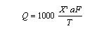 (3)
(3)
Where:
Q – Groundwater discharge, m3/day
Xl – Norm of precipitation for warm
season (from April to November), mm/year
a – Coefficient of infiltration
F – Groundwater discharge area, km2
T – Warm season continuation, days.
The methodologies and data used (often historical data from local Aimag and Soum centres coordinated by the
Mongolian Academy of Sciences) provide only rough calculations which need to be
refined incorporating modern methodologies such as radioisotope or stable
isotope analysis.
Utilising groundwater resources
In terms of accessing groundwater resources, a census conducted by the
Ministry of Food and Agriculture during 2003 estimated a total of 40,900 wells
in Mongolia (NSO, 2005). Of this total, 19,500 were
engineer-constructed wells and the remaining 21,400 were simple mine
wells. Additionally, there were 32,300
pasture irrigation systems, 12,800 unused wells and 1,600 tanks for livestock
watering (NSO, 2005). The statistics specifically for
the number of wells in the Selenge River Basin were not
available, however given that the bulk of the nation’s population and industry
lies in this basin, it is estimated that a significant proportion of wells
would be located within this basin (for example, refer to Table 9, where it is estimated that
approximately 6,000 wells exist within the Selenge River Basin for pastureland purposes alone).
Additionally, many groundwater bores and wells are in desperate need of
refurbishment or reconstruction. This is particularly
the case in isolated pastoral areas where many dysfunctional wells necessitate
high concentration of both humans and livestock around the few reliably
operating wells, leading to severe land degradation problems.
Water Resource Development
The Selenge River Basin resource is critical in sustaining current industries and developing new
ones.
Traditionally, industry in Mongolia has occurred on a small scale and been chiefly centred in the capital of Ulaanbaatar. However, recent expansion of
industry and strong rural-to-urban migration trends inUlaanbaatar and other major centres, coupled with expansion of other sectors into
new regions, particularly mining and tourism, have dramatically increased
demands for reliable water sources.
Accessible, good quality water sources are critical factors in
supporting livelihoods and facilitating the growth of all sectors. Due to the extent and severity of the winter months, surface water
resources are frozen solid and inaccessible for the majority of the year. However, groundwater resources, protected from such harsh conditions,
can provide year-round water supplies during such difficult conditions.
The enormity of the Selenge River Basin groundwater resources has already facilitated great development within
this area. However, very little information
about the water resources generally, and in particular the groundwater
resources, is known for the Selenge River Basin.
Hence, there is a strong need to qualify and quantify the resources to
ensure sustainable development occurs and all stakeholders have appropriate
access to water resources.
During 2003, an estimated total of 700,000 m3/day of water was abstracted from the basin’s
groundwater system. Although there are a number of
significant groundwater demand centres, Ulaanbaatar was the greatest consumer of
groundwater from the basin (340,000 m3/day), followed by the major
regional towns of Erdenet (165,000 m3/day)
and Darkhan (140,000 m3/day),
(both of which contain large mining and industrial activities as part of their
demand). In addition to these major
cities, other mining industries (25,000 m3/day), other Aimag centres (10,500 m3/day), Soum (sub-province) centres (12,000 m3/day) and pastoral use
(6,000 m3/day) accounted for the remaining consumption.
Urban centres
Groundwater in cities is generally consumed in central water supply
systems (used for potable water and heating), factories and power plants, and
wells for private consumption (not connected to central water supplies). Groundwater sources typically provide all the required water demands for
major urban centres (as the availability of surface water sources is highly
seasonal and often inaccessible).
The major urban centres within the basin include Ulaanbaatar, Erdenet, Darkhan and the other aimag centres.
Ulaanbaatar
Ulaanbaatar is the capital city of Mongolia, with a population of approximately 930,000 inhabitants (NSO,
2005). It is the major centre for
governance, commerce and industry in Mongolia. Groundwater sources in Ulaanbaatar are chiefly used for electricity and heating generation (at two major
power stations), domestic purposes, meat processing, wool cleaning and in
tanneries.
Currently, an estimated 143 production wells supply Ulaanbaatar’s central water supply, as well as 200 wells for factories
and power plants and 320 wells for ‘ger’ (traditional
tent-like housing) suburbs (Table 5). The 663
wells serving Ulaanbaatar abstract approximately 340,000 m3 of groundwater per day (Table 5).
Table 5 – Groundwater Consumption Statistics
for Ulaanbaatar
|
Water
User |
No.
of wells |
Yield,1000m3/day |
City
Location |
|
Upper
Water Source |
41 |
25.2 |
Central
Area |
|
Central
Water Source |
76 |
119 |
Central
Area |
|
Industrial
Water Complex |
18 |
34.8 |
Central
Area |
|
Meat
Complex Water Source |
8 |
13.8 |
Central
Area |
|
Power
Plant #3 |
13 |
43.6 |
Central
Area |
|
Power
Plant #4 |
12 |
25.2 |
Lower
Area |
|
Other
Factories |
175 |
52.5 |
Central
Area |
|
Ger
Suburbs |
320 |
25.6 |
Ger
Suburbs |
|
Total |
663 |
339.7 |
|
The single largest consumer of water in Ulaanbaatar is the Central Water Source,
which supplies water for domestic and commercial purposes in the built-up
central section of the city. This sector consumes
35% of the cities total water demand. Factories and power plants constitute the other major water consumers in Ulaanbaatar. Water for these sectors is
chiefly abstracted from alluvial aquifers bordering the Tuul River, which flows through the city.
The greatest numbers of wells (48%) are located in the ger suburbs (for domestic use), however these are generally low yield wells
(yielding only 8% of the city’s total consumption). These suburbs house the
majority of dwellers in Ulaanbaatar city, and the proportion of these households is increasing as many
families migrate from rural to urban areas in the hope of greater employment,
education and healthcare opportunities. There are great challenges in
meeting the demands of these incoming urban residents and particularly
maintaining the integrity of groundwater sources in these areas as suburban
development and waste disposal proceeds largely unplanned.
Effective access to, and provision of, water supplies for all Mongolians
needs to be addressed to increase the national average availability to 20
litres of water per person per day. Currently, water consumption in the ‘ger’ suburbs is limited to 5-8 litres per person per day, which is 2.5-4
times less than the internationally accepted minimum of 20 litres per person
per day (UNDP, 2004).
Erdenet
Erdenet city is located approximately 230km northwest of Ulaanbaatar city. Groundwater in Erdenet is chiefly used for electricity and heating generation, domestic
purposes, a food processing factory, a carpet factory and copper and molybdenum
mining. Erdenet city currently
contains 16 production wells and 24 proposed exploration wells and consumes 55,000 m3/day for domestic and commercial purposes, whilst an
additional 110,000 m3/day is
consumed in mining and industrial processes.
The chief Erdenet borefield is located approximately 60km from Erdenet city near the Selenge River. Water is supplied to the city and
surrounding mine by a large diameter water supply pipeline. The distance over which the water is conveyed illustrates the heavy
reliance of this community on the alluvial groundwater resource of the Selenge River.
Pump tests conducted during 2005 in 16 wells in Erdenet provided information
on aquifer depth, thickness, drawdown levels, yield and filtering
coefficient. These results are summarised in Table 6.
Table 6 - Range of Pumping Test Results from 16 wells in Erdenet
|
Depth,
m |
Water
Table, m |
Thickness,
m |
Draw
Down, m |
Yield,
L/sec |
FilterCoeff.
m/day |
|
41.0
– 44.5 |
0.27
– 2.17 |
31.8
– 42.1 |
0.67
– 27 |
99 –
144.7 |
114.8
– 398.6 |
The pumping test results demonstrate that the
groundwater table in the alluvial aquifers is very close to the surface and the
aquifer thickness is moderate. Yield measurements
were generally high, howeverdrawdowns varied greatly and were
potentially significant.
Table 7 provides a further example of the reliance of major water consumers (in
this case the Erdenet Heat Power Plant
(HPP)) on groundwater resources. The table
demonstrates that surface water resources provide just 0.3% of the water demand
for the heat power plant which services Erdenet city.
Table 7 – Surface and Groundwater Consumption at the Erdenet Heat Power Plant (HPP)
|
Water
Source |
Tech.
Requirements |
HPP
Buildings |
City
&Indust. |
Total |
|
Surface
Water |
7 |
- |
- |
7 |
|
Off-siteG.water |
245 |
8 |
2000 |
2252 |
|
On-siteG.water |
53 |
- |
- |
53 |
|
Total |
305 |
8 |
2000 |
2312 |
All figures in m3/hr
Darkhan
Darkhan city is located approximately 170km north of Ulaanbaatar city. Darkhan utilises
approximately 140,000 m3/day of
groundwater resources for the purposes of electricity and heating generation,
domestic use and supply to iron, cement and ceramics factories. Darkhan city contains 18 production wells with a total yield of 726 L/sec.
Like Erdenet, the bulk of Darkhan’s water supplies come from groundwater sources along a major drainage
line. The Orkhon River flows to the north of Darkhan city and the bulk of groundwater is sourced from the river’s shallow
alluvial aquifers.
Other Urban Centres
Other aimag centres in the Selenge River Basin, including Tsetserleg, Bulgan, Sukhbaatar, Zuunmod and Hutul consume a combined total of
approximately 10,500 m3/day.
Like the three major urban centres, the aquifers chiefly utilized as
water sources for the other Aimag centres are also alluvial
deposits. Based on calculated recharge
rates for local aquifers in five aimag centres, it is estimated that approximately 1/3 of the total available
sustainable local groundwater yield is currently being utilized. However, the percentage of the available local sustainable yield being
consumed at individual aimagcentres ranges from 20% (at Tsetserleg) to 44% (at Zuunmod) (refer to Table 8).
Table 8 – Hydrogeological Data from Aimag Centres
|
AimagCentre |
No.
Well |
Est.Sust.
Yield, m3/day |
Current
Use, m3/day |
Yield
of wells, L/s |
MainBasin* |
|
Tsetserleg |
24 |
10,080 |
2,000 |
1–31 |
AD |
|
Bulgan |
18 |
4,910 |
1,720 |
1-13 |
PS |
|
Murun |
28 |
6,600 |
2,300 |
1-33 |
AD |
|
Sukhbaatar |
15 |
7,480 |
2,850 |
0.9-40 |
AD |
|
Zuunmod |
13 |
3,700 |
1,640 |
0.7-18 |
AD |
|
TOTAL |
98 |
32,770 |
10,510 |
0.7-40 |
|
*AD = Alluvial
Deposit/Schist, PS = Permian Sandstone
In addition to the Aimag centres, there are 93 Soum centres within the basin
utilising approximately 12,000 m3/day of
groundwater resources. A study on domestic water
supplies, conducted in 2004 by theInstitute of Geoecology, showed that for all Soum centres about 65% of well yields were used during winter, while 15% were
used in summer, with the remainder used in shoulder periods. High winter yields of groundwater resulted from inaccessibility to
frozen surface waters during this period.
Grazing Lands
As with many areas within Mongolia, the grazing
of livestock is a major industry within the Selenge River Basin. The grazing of livestock has
traditionally been the livelihood of nomadic herders for centuries and this
form of industry still forms a major part of the modern economy.
The quantities of groundwater consumed by nomadic herders and their
livestock at watering points are difficult to quantify. The Mongolian central government, in conjunction with the Aimag and Soumgovernments, endeavours to record
these figures, however there are limited records available and hence estimates
are potentially inaccurate.
A survey conducted by the Institute of Geoecology identified a total of
5,790 wells within the pasture land territory of the Selenge River Basin (Table 9). There are three major categories
of pastureland wells, namely Deep Wells, Shallow Tubular Wells and Shaft Wells.
Table 9 – Wells in pasture lands of the Selenge River Basin
|
Aimag |
Deep
Wells |
Shallow
Tubular Wells |
Shaft
Wells |
|||
|
No. |
Specific
Yield, L/s |
No. |
Specific
Yield, L/s |
No. |
Specific
Yield, L/s |
|
|
Bulgan |
327 |
0.1-13 |
243 |
0-22 |
304 |
0-5 |
|
Khovsgol |
364 |
0-14 |
365 |
0-5 |
23 |
0.1-1 |
|
Selenge |
363 |
1-30 |
254 |
0.1-3 |
118 |
0-1 |
|
Tov |
573 |
0.8-40 |
165 |
0-4 |
854 |
0-5 |
|
Arkhangay |
455 |
0-13 |
730 |
0-1 |
652 |
0-1 |
|
TOTAL |
2082 |
0-40 |
1757 |
0-22 |
1951 |
0-5 |
The majority of wells are within Arkhangay (1,837) and Tov (1,592) Aimags. The yield of the pastureland
wells range from 0 (not operational) to a maximum of 40 L/sec. The deep wells yielded the
greatest volumes of water, while the shaft wells yielded the least. Pastureland bores, often located away from drainage lines, tend to necessitate
access to deeper aquifers. This is demonstrated
by only 30% of pastureland bores being of the “Shallow Tubular” variety.
Many of the pastureland bores are believed to be non-operational, due to
a combination of lack of ownership, neglect and poor maintenance over many
years. There is a great need to repair
dysfunctional bores or drill new bores as livestock ranges are limited by the
availability of freshwater supplies. This, in turn, leads to severe overgrazing of areas near watering points
and under utilisation of areas isolated from reliable watering
points.
Croplands
Although cropland production in Mongolia is limited, the Selenge River Basin is the chief region for this form of agriculture.
Irrigation waters for vegetable and fodder crops, where required, are
sourced from local surface waters and groundwaters during the summer months. In the greater
context, abstraction for these purposes is minimal compared to all of the other
sectors. However, this sector may expand
in the future as demand for locally grown vegetable and grain products
increases.
Mining
Many of the major mining industries in Mongolia are situated within the Selenge River Basin (the Gobi desert is the other major mining
centre outside the basin). Large,
well-established mining operations are located in places such as Erdenet, where the industry sustains many local livelihoods, while many smaller
mining activities (including illegal mining activities) are being undertaken, particularly
in stream and river beds. Mining industries consume water
chiefly for the washing of deposits but also for domestic purposes to supply
basic heating and potable water needs of seasonal mining workers.
Mining operations have markedly increased since the creation of a
market-based economy, with many international and national companies now
holding interests in Mongolia.
Traditionally, private mining entities have been reluctant to share
technical information about their operations, hence details about groundwater
abstraction is limited and may be under-estimated.
There is much anecdotal evidence of mining operations desiccating
surface waters through diversion of river flows and polluting downstream waters
with contaminants. Recently, there has been growing
public awareness of the negative effects of irresponsible activities on local
environments and stakeholders and this has spurned the establishment of
community groups to speak out about sometimes dubious activities.
Tourism
Tourism is a growing industry in Mongolia. Since the country abandoned its
socialist economic structure in 1990, Mongolia’s popularity
as a tourist destination has been slowly increasing.
Tourism in Mongolia is highly seasonal, with peak periods occurring between June and
September (the mild summer months). Tourism consists of both international visitors and domestic
travellers.
Lake Hovsgol, in the Hovsgol aimag in the north of the country, is Mongolia’s number one
tourist attraction outside Ulaanbaatar. In addition to the continuing growth of many of the other sectors in the SelengeRiver Basin, tourism is an expanding industry, particularly on the
western side of Lake Hovsgol, and in national parks and other recreational areas around Ulaanbaatar.
Tourist camps utilise wells, streams or springs to supply water and must
manage wastewater and solid wastes.
Potential threats to groundwater
sources
In addition to providing the major water source for urban centres,
nomadic herders and their livestock, croplands, mining and tourism in the Selenge River Basin, groundwater (and surface water) resources also sustain
important flora and fauna in the region. The integrity of the groundwater resources is critical in providing
reliable, safe supplies for human utilization and maintaining the function of
natural ecosystems.
In addition to managing the sustainable yield of such resources, there
are also many pollution threats which can potentially jeopardise groundwater
systems. Anthropogenic sources of water
pollution in the basin include:
1. effluent discharged from
wastewater treatment plants;
2. gold-mining activities (both
legal and illegal), particularly in lower catchment areas;
3. other mining activities,
including copper mining and associated tailings dams and dust mobilization;
4. the leaching of solid wastes from
disposal areas;
5. agricultural runoff from animal
husbandry and croplands; and
6. thermal pollution via discharge
water from thermal power plants.
Wastewater discharges
There are over 80 wastewater treatment plants in the Selenge River Basin. Some major towns, as well as aimag and soum centres contain basic sewerage
systems. Mechanical and biological treatment
systems are present in larger schemes, while simple primary settlement or pond
systems are present in smaller schemes. Much of the infrastructure in these systems is outdated and contingency
measures for events such as power shortages or heavy rainfall events are either
non-existent or poorly developed. Hence, discharge of untreated sewage into local receiving environments,
including streams and rivers, is not uncommon. This causes chiefly localized ammonium nitrogen pollution and also poses
potential pathogen-related health risks.
Mining Activities
Many mining industries began in 1990, during the transition from a
socialist-to-capitalist economy. Development of this
sector was rapid and proceeded largely unlegislated and unregulated.
Gold-mining was the most lucrative newly discovered venture and
attracted much activity. However, the quest for the
discovery of deposits of this valuable mineral resource often came at the
expense of the local environment. For example, along a 70km section of a river in the Selenge Aimag, 46 gold-mining ventures were concurrently operating in the river bed
and, in addition to the drastic alterations caused to the river flow and local
morphology, they also adversely impacted over 9000ha of fertile agricultural land on
either side the drainage line (Jadamba, N., 2006). Furthermore, the sustainable rate of consumption of local surface and
groundwater resources has already been exceeded in many high demand areas,
including the Tuul and Shariin River Basins close to Ulaanbaatar.
Illegal gold-mining activities exacerbate the problem, as the simple,
inefficient methods applied require the movement of many tons of soil and
earth. This increases the siltation of rivers and results in many downstream rivers and lakes drying
out. In many cases, illegal
gold-mining is seen as a way for poor rural dwellers to alleviate
poverty. Illegal gold-mining represents
one of the fastest growing sources of new employment in rural areas, with
approximately 50,000 people operating illegally (called ‘ninjas’) along
drainage lines during the summer months (Jadamba, N., 2006).
Additionally, leakages from tailings dams can release heavy metals and
other contaminants used in processing into downstream areas and the
mobilization of large amounts of dust during soil excavation can contribute to
the local siltation of stream channels.
Solid waste disposal
Inappropriate disposal of solid wastes can result in leaching of
contaminants into groundwater systems and ultimately into surface waters,
making them a major health hazard and unsuitable for use by humans or
animals.
The leaching of contaminants from decaying solid waste is a potential
problem at official landfill sites that have not been adequately lined (if at
all) and the many make-shift waste dump sites, particularly within theger suburbs on the outskirts of major settlements.
In Ulaanbaatar, approximately 0.0025m3 of waste is generated per person
per day from apartments, while 0.005m3 (winter) – 0.0012m3 (summer) is generated per person per day in ger suburbs (Oyunbaatar, C., 2002). Waste in the ger suburbs is greatest in winter, as
approximately 60% is waste ash burned for heating and cooking. Waste collection areas in the ger suburbs are not fenced or lined and waste collection services are
erratic and infrequent.
Furthermore, one of the major official landfill disposal sites in Ulaanbaatar, Dari-Ekh, is located in a catchment zone for the Selbe and Tuul Rivers and upstream of ger suburb zones where residents
abstract water from wells and springs for drinking and cooking purposes.
The amount of solid waste generated in Ulaanbaatar city is increasing approximately
10% annually (Oyunbaatar, C., 2002), hence the problem of
effective solid waste disposal is also growing in seriousness.
Additionally, septic systems and ‘pit toilets’, which are ubiquitous in
the ger suburbs, also leach septic
contaminants into groundwater sources.
Agricultural runoff
Mongolia is often referred to as “the land
with no fences.” This reflects the traditional
nomadic or semi-nomadic lifestyle of herders and the associated lack of
recognized static property boundaries (in the context of contemporary property
rights). Hence, the majority of natural
resources, including water resources, are accessible to all and this access is
largely uncontrolled (however, this concept is gradually changing).
Uncontrolled livestock access to river beds and fragile riparian zones
contributes to erosion problems and agricultural pollution, in terms of direct
discharge of faeces and urine into surface waters (and indirectly into groundwaters) occurs unabated. Increases in the number of
livestock per household in recent years have intensified this source of
pollution.
Also, relative inexperience in cropland production, coupled with
insufficient processes in place to direct and control areas to be cultivated,
may also lead to contaminants, such as fertiliser or herbicide runoff, entering
water sources.
The intensity and continued growth of both pastoral and cropland areas
in the Selenge River Basin confirms
these land uses as serious potential pollution sources that need to be addressed
in a wider integrated land and water management plan.
Thermal discharges
Mongolia’s prolonged, severe winter months necessitate the urban
populations’ reliance on centralized heating systems. Thermal power plants heat water for distribution throughout built-up
sections of major urban centres. The ultimate
discharge of heated water into local receiving environments can harm ecosystems
by raising local water temperatures far beyond normal levels.
Multiple thermal power stations are present in Ulaanbaatar city and some of the aimag centres. Thermal discharges from the power
stations in Ulaanbaatar are released into the Tuul River.
Miscellaneous Activities
A negative consequence of a number of activities in combination, coupled
with larger issues such as climate change, is the desiccation of water
resources.
A surface water census report conducted in 2003 concluded that
nationally there were a total of 5,621 rivers, of which 12% (702) were dried up
(NSO, 2005). Within each of the aimags in the Selenge River Basin they
contained the following number of rivers: Arkhangai (546, of which 23% were dried up), Bulgan (449 of which 14% were dried up), Zavhan (217 of which 9% were dried up), Selenge (596 of which 15% were dried up), Tov (537 of which 18% were dried up), Hovsgol (1,233 of which 6% were dried up) and Khenty (246 of which 7% were dried up) as well as the municipality of
Ulaanbaatar (72 of which 31% were dried up). Within the Selenge River Basin the percentage of dried rivers
was higher than the national average. Although climate change effects are difficult to quantify in different
regions of Mongolia, the higher percentage of dried rivers in Selenge River Basin, particularly around Ulaanbaatar, could be resultant from
the increasing pressures applied by migrating populations, industry, mining and
pastoral landuses. Lowering of groundwater tables through over-abstraction and diversion of
surface waters from there natural drainage lines would be the two major local
causes of desiccation.
The 2003 surface water census report also concluded that nationally
there was a total of 9,600 springs of which 15% (1,484) were dried up (NSO,
2005). Within each of the aimags in the Selenge River Basin they
contained the following number of springs: Arkhangai (474, of which 26% were dried up), Bulgan (668 of which 36% were dried up), Zavhan (444 of which 4% were dried up), Selenge (208 of which 34% were dried up), Tov (413 of which 25% were dried up), Hovsgol (969 of which 20% were dried up) and Khenty (588 of which 30% were dried up) as well as the municipality of
Ulaanbaatar (106 of which 21% were dried up). Again, like rivers, within
the Selenge River Basin the percentage of dried springs was higher than the national
average. Much of this drying out,
particularly around Ulaanbaatar and other major centres, again could be resultant from pressures applied
by migrating populations, industry, mining and pastoral landuses.
The 2003 surface water census report also concluded that nationally
there were a total of 4,196 lakes, of which 18% (760) were dried up (NSO,
2005). Within each of the aimags in the Selenge River Basin they
contained the following number of lakes: Arkhangai (249, of which 13% were dried up), Bulgan (254 of which 11% were dried up), Zavhan (118 of which 2% were dried up), Selenge (46 of which 13% were dried up),Tov (235 of which 31% were dried up), Hovsgol (642 of which 5% were dried up) and Khenty (247 of which 26% were dried up) as well as the municipality of
Ulaanbaatar (4 of which 25% were dried up). Within theSelenge River Basin the percentage of dried lakes was slightly lower than the national
average. The majority of dried lakes were
located in Bayan Olgii (extreme west) and Dornod (extreme east) aimags. Population pressures in these regions are less than in the Selenge River Basin, however annual rainfall is also less. Also, lakes are highly dependent on upstream water sources (streams, rivers
and springs) hence a dry lake in oneaimag may be the result of poor river or spring management in another aimag.
Groundwater balance
The annual recharge across the Selenge River Basin has been estimated at 5.6 x 10⁹ m3/yr (Table 4). Additionally, by the summation of
available consumption figures across the urban, commercial, industrial, mining,
agricultural and recreational sectors within the same basin, it is estimated
that an average annual abstraction volume of 2.55 x 10⁸ m3/yr (700,000 m3/day)
is consumed. Therefore, the average annual
consumption equates to approximately 5% of annual average recharge.
Although the percentage of recharge volume being utilised seems minor,
more information needs to be gained on the dynamics and interactions of
groundwater systems before recommendations to maintain current levels of
abstraction, let alone recommend increases, can be made. The estimates provided are based on multiple assumptions and
generalizations for the basin. Furthermore, current
rates of recharge are likely to be maintaining pressures in confined aquifers
and levels in unconfined aquifers and hence directly determining stream and
spring flows.
Many urban and industrial centres; particularly Ulaanbaatar, Darkhan and Erdenet, may already be exceeding the sustainable limit of local aquifer
systems within each of the fourteen sub-basins. For example, annual groundwater use in Ulaanbaatar city amounts to 124 x 106 m3/yr, or
approximately 15% of the entire annual recharge volume for the Tuuliin sub-basin (Table 4), in which the city is
situated. Given the large area of theTuuliin groundwater sub-basin (44,013 km2) and the relatively small
area occupied by Ulaanbaatar city, there is little doubt that such concentrated groundwater
abstraction to satisfy urban and industrial demands must be grossly exceeding
annual recharge rates in the local aquifers of this sub-basin. Continued and further increases in abstraction in areas supporting great
demand centres may seriously jeopardise the future of those resources.
Additionally, to compound the problem, the central eastern and southern
sections of the basin, where annual rainfall is generally lowest, and hence
recharge is lower, are also the regions with the highest population densities
and greatest water demands.
Discussion
Since the transition from a socialist economy to a market-based economy
there has been significant growth in many sectors. Increased economic growth has generally led to increased demands on
water sources, particularly in the mining and agricultural sectors. It is foreseen that these demands will continue to increase. It is essential that a balance is maintained and all stakeholders are
given adequate access to the scarce water resources which are so critical for
survival in such a harsh climate.
Given the preliminary studies that have been undertaken, although
overall only a relatively small percentage of the Selenge River Basin groundwater resources appear to
be being consumed, it is very likely that there is localised over-exploitation
of some aquifers in the major urban and industrial centres. Therefore, it is important to not only study the Selenge River Basin as a whole system, but to also
study each of the 14 sub-catchments and determine the sustainable yields of
each of those smaller systems. Groundwater
distribution, like the population dispersion above them, may be highly
heterogenous. There is a danger that many large
demand centres, such as Ulaanbaatar city and other industrial and mining hubs, will overexploit the
available local groundwater resources. Localised over exploitation could lead to significant long-term
disablement of the resource. Furthermore, it is
expected that the concentration of populations in small centres will continue
to increase as rural to urban migration patterns continue.
Another consequence of increased urbanization and industrialization will
be the pollution of the groundwater sources themselves. Waste and wastewater products disposed of incorrectly may leach
contaminants into groundwater systems (particularly unconfined systems) and
compromise accessing to those resources.
A comprehensive policy on integrated watershed management, covering
utilization and protection, is absent in Mongolia. The approaches used for
developing policies are not coherent and holistic with ministries and agencies
operating independently and considering specific policy aspects instead of the
bigger picture.
Furthermore, the allocation of responsibility between institutions with
regard to policy making, research, monitoring and management is unclear. Additionally, capacities and funding within the civil service are also
weak and require reform.
A concerted effort of effective coordination and reform will be required
to improve accessibility to water resources for all sectors of the community,
whilst still maintaining environmental values.
Recommendations
The importance of groundwater resources in the context of both present
and future sustainable development in Mongolia cannot be overstated. However, currently,
the knowledge and understanding of these critical assets is limited and hence
there is potential for unknowing overexploitation and mismanagement to
occur.
There must be close cooperation and collaboration between all
stakeholders, including research-based organizations, government institutions,
community and environmental groups and multilateral organizations.
Research strategies
In order to prevent overexploitation and mismanagement, further research
work needs to be undertaken in the Selenge River Basin. The irregular distribution of
groundwater resources in the Selenge River Basinrequires
further hydrogeological studies to accurately
qualify and quantify these resources. Specifically, the volume of the total resource, and subsequently the
annual sustainable yield, needs to be quantified. As part of the greater understanding of the resource, the specific
dynamics of the interactions between aquifers and recharge rates also need to
be calculated.
Due to the great spatial extent and irregularity of groundwater
resources in the basin, coupled with the equally heterogeneous concentration of landuses within the basin, it is important to manage each sub-catchment
individually within a greater overall management plan. Sustainable yields for each sub-catchment need to be determined to
ensure maintenance of current groundwater levels and environmental flows for
rivers within the basin. Parameters such as volume of
resource, sustainable annual yield, aquifer dynamics and recharge rates need to
be calculated for each sub-basin to create individual management plans and
assist in strategic planning to assist in recommending optimum locations of
future industrial and urban centres. Modern methods of investigation, such as radiocarbon or stable isotope
analysis, could be used to assist in further understanding the groundwater
systems.
Institutional Strategies
Mongolia still faces significant
challenges in the difficult transition from one economic system to
another. Currently, the management of
water resources is fragmented between seven ministries. Hence there is a great need to reconsider and redevelop strategies and
policies with regard to all natural resources, particularly water
resources. Of great importance is the
allocation of water resources for all stakeholders, including environmental baseflow requirements. Currently, it appears that some
stakeholders (e.g. mining entities) are consuming large quantities of water and
negatively affecting the quality of such resources, at the expense of other
stakeholders. These inequities need to be
resolved.
Public involvementstrategies
Although there are many institutional improvements which must be made to
effectively manage the groundwater resources of the Selenge River Basin, there also needs to be an education campaign targeted at
the public and a general promotion of groundwater- and water efficiency-related
issues. The public needs to be involved
in, and aware of, decision-making processes that impact their local
communities. Evidence of increased public
involvement to date has been the establishment and activities of community
groups drawing attention to water-related issues, particularly issues resulting
from mining practices.
Management strategies
Sound management strategies need to be developed in parallel with
research findings and institutional reform. A suite of management strategies need to be developed at local, regional
and even international levels.
International level management
At the international level, the Selenge River Basin should be managed cooperatively
by Mongolia and Russia for the benefit of both countries. A sound international management strategy would minimise potential
conflict between the two neighbouring countries and promote fair and efficient
use of water resources.
Regional level management
Regional level management would encapsulate a holistic management
strategy for the Selenge River Basin (including all 14 sub-catchments) within Mongolia. Within this holistic strategy
there would exist sub-management strategies for each of the sub-catchments.
A management body should be established to oversee and implement
regional strategies and activities. Regional tasks coordinated by the management body could include:
l cooperation with research
institutions to study the groundwater systems and changing land uses within the
basin;
l cooperation with government
authorities to upgrade water and wastewater infrastructure as well as
establishing solid waste disposal strategies to protect water sources;
l establishment of regional
monitoring programs and mitigation activities;
l identification of areas where
future borefields (and potential
developments) could be located;
l development of a regional well
rehabilitation/renewal strategy to facilitate more uniform distribution of
herding and cropland activities; and
l being the facilitator of dispute
resolution between stakeholders.
Local Level Management
Local level management would constitute implementation of regional
management strategies and may be undertaken by existing authorities at the Aimag and/or Soum level.
Specific tasks to be undertaken at the local level include implementing:
· rehabilitation/renewal of wells
in the local area;
· upgrades of local water and
wastewater infrastructure;
· groundwater and surface water
monitoring plans; and
· establishment of designated solid
waste disposal areas for urban and industrial centres.
References
[1] Geosystems Global Corporation, 2006,
www.mongolembassy.org
[2] Institute of Geoecology, 2005, Water Resources Division Archives, Mongolian Academy of Sciences, Ulaanbaatar, Mongolia.
[3] Jadamba, N., 2006, Personal Communications, Institute of Geoecology, Mongolian Academy of Sciences, Ulaanbaatar, Mongolia.
[4] Jadamba, N., Grimmelmann, W. & Kampe, A., 2003, Hydrogeological Map of Mongolia, 1:1,000,000 Explantory Notes, pp. 7-45, Hanover, Germany.
[5] Janchivdorj, L., 2005, Current Social and Environmental Situation of the Selenge River Basin and Associated Management Challenges, Institute of Geoecology, Mongolian Academy of Sciences, Ulaanbaatar, Mongolia.
[6] Kartavin, B.A. & Marinov, H.A., 1976, Methods of Natural Groundwater Recourse Surveying and
Evaluation in Arid Zones of Mongolia, joint Soveit-Mongolian Scientific Research Expedition, Vol 16, pp 7-104, Moscow.
[7] Kudelin, B.I., 1960, Principles of
Regional Estimation of Groundwater Natural Resources, pp 55-209, Moscow State
University, Russia.
[8] Legend Tour, 2006, www.legend.tour.ru
[9] Ministry of Water Economy, The People’s Republic of Mongolia, the Institute of Scientific Exploration and the Project on Water, 1986, Atlas of Water
Resource Protection and Utilization in the Selenge River Basin, Ulaanbaatar, Mongolia.
[10] National Atlas of Mongolia, 1990, pp. 61, Moscow.
[11] National Statistical Office of Mongolia, 2005, Mongolian Statistical Yearbook
2004, Ulaanbaatar, Mongolia.
[12] Oyunbaatar, C., 2002, The Current Status and Management of Solid Waste Treatment in Ulaanbaatar
City, Mongolia, Department of Furnishing, Manufacturing and Service, Governor’s
Office, Khan-UulDistrict, Ulaanbaatar, Mongolia.
[13] Transboundary Freshwater Dispute
Database, 2000, www.unesco.org/water.
[14] United Nations Development
Program, 2004, Access to Water and Sanitation
Services in Mongolia, United Nations Mongolia Office, Ulaanbaatar, Mongolia.
[15] Wolf, A.T., Natharius, J.A., Danielson, J.J, Ward, B.S. & Pender, J.K, 1999, International River Basins of the World, International Journal of Water
Resources Development, Vol. 15, No. 4, Dec 1999.
Acknowledgements
The authors would like to acknowledge the Institute of Geoecology, Mongolian Academy of Sciences, for its support in
the fieldwork and administrative aspects of this project.
Specific thanks must be extended to the following staff at the Institute
for their assistance:Janchivdorj L., for providing technical information; and