


Achievements
THE GROUNDWATER RECHARGE AND GEOCHEMICAL EVOLUTION FROM HEXI CORRIDOR TOINNER MONGOLIA PLATEAU, THE THE ARID ZONES OF NOTHWEST CHINA
J.Z. Maa, , Z.
Y. Dinga T. M.
Huanga, Y.
H. Sub
a Key Laboratory of Western
b Cold and Arid Regions Environmental and Engineering Research
Institute,
Abstract:The long term
recharge in Hexi corridor and Inner Mongolia Plateau was estimated to be
Key words: Groundwater, Recharge,
Geochemistry, Isotope, Hexi corridor, Inner
Mongolia Plateau
1.
Introduction
Over the past decades, the Chinese government and scientists have
carried out much research on the assessment, development, utilization and
conservation of groundwater resources in northwest. However, the previous
methods of groundwater research are mainly based on water balance, which are
inadequate for low rainfall areas with high evapotranspiration(Allison et al.,1994). Research
interests have been focused on aspects such as utilization survey, evolutionary
prediction, reserve estimation and systematic assessment of natural water
resources. Some reasonable allocation and utilization plans have been proposed.
Study of the hydrochemistry (especially isotopic geochemistry) of water
resources is rather sparse and past work on the arid area has dealt largely with
the chemical properties of the water, and efforts to use the geochemistry data
available to solve particular problems are even fewer or non-existent, although
there are several investigations on the interaction and mechanism between
surface water, groundwater and rock in particular areas in recent years (Shi et
al., 2001; Feng et al, 2004; Zhang et al., 2005). Shi et al. (2001) have
reported stable isotope data showing values of –6.6 to –9.7 δ18O
which they claim to represent modern recharge, modified by evaporation and that
the groundwater is sourced from the
However, it is short
of the regional understand of the groundwater recharge and chemical evolution,
the volume of water available in the aquifer is not known and its rate of
recharge, if any, is very uncertain. However, there can be little doubt that
water is being extracted much more rapidly than it is being replaced, that
surface water supply is threatened by global warming, that the quality of water
may change as volume declines, and that local farmers have little understanding
of the problem(Ma et al., 2005(a)). This is an issue that faces the whole
regions of arid
The scope of the present study and the main objective is to
estimation of natural groundwater recharge to aquifers, and understand the
groundwater evolution and identify chemical changes taking place along the
original direction of groundwater flow towards the terminal
l use the geochemical and isotopic technology to determine the
present day recharge rates from unsaturated zone of Desert,
l determine which are the predominant geochemical process taking
place along the inferred horizontal groundwater flow line,
l use stable isotopes and tritium to determine the evolution and the
age of the groundwater under the natural conditions during the recent geological
past.
This approach has been used successfully in other semi-arid
regions underlain by large freshwater resources (Edmunds et al., 2003). Similar
comprehensive approaches to groundwater understanding combining chemistry and
isotopic indicators are relatively few in China but palaeoclimatic studies
combined with chemistry are beginning to show that basins in Northern China
were recharged under wetter conditions in the past and therefore non-renewable
(Chen Z et al., 2003). Improved understanding of the resource therefore is
fundamental to many important decisions that will need to be made in
2. Geology and
Hydrogeology
The study area includes the Shiyang river basin, Heihe basin and
Baddain Jaran desert. From
southwest to northeast, landforms can be divided into the
The Hexi Corridor, located on the northeast margin of the
Qinghai–Tibet Plateau, is a Cenozoic foreland basin system. The subduction of
the Indian Plate under the Eurasian Plate caused the Qinghai–Tibet Plateau to
become uplifted and pushed to the north (Harrison et al.,. 1992). The fault
zone at the northeast front of the
From the late Tertiary, especially from the end of the Pliocene
and the beginning of the early Pleistocene, the surrounding Tibetan mountains
began to rise up rapidly (Li et al., 1979) and the basins subsided further. At
the same time the intensive denudation and erosion from the mountains led to
significant transfer of clastic material to the basin depressions. This
formation of thick Quaternary diluvial and alluvial sediments, and some aeolian
and lacustrine deposits, led to the formation of the main aquifers.
Huge
loosen Quaternary sediments with maximum over
The active reverse faults
zone and derivative Cenozoic fold
along the North piedmont
However, the Quaternary aquifers are all closely connected with
streams originated in the Qilian mountains which discharge the tectonic
fracture groundwater. These streams pass through two or three basins and flow
into the terminal lakes once the
runoff formed by melting ice-snow, precipitation and the springs in the
mountains. There is a complex transformation relation between the surface and
groundwater. More than 80%of surface water in the piedmont fan seeping down to
the aquifer and then in the fine earthy plain belt, about 40% of groundwater discharge to feed the
spring and river. Such transformation process of surface water to groundwater
and then to surface water again in the quaternary basins maybe repeated many
times because of the existence of tectonic uplifted zone in the middle of the
Hexi corridor such as Longshou-Hongya Mountain, Heli-Mazong Mountain and some
small hills, which led to groundwater barely crosses the fracture from south
basin to recharge the north basins.
3
Methods
Field work took place from the summer of 1999 to September of 2003
during which several profiles are drilled with augurs and about 100 groundwater
samples were collected. All groundwater samples were filtered (0.45um membrane
filters) and an aliquot acidified with 1% HNO3 for analysis of trace elements.
Unacidified samples were collected for anion analysis as well as for stable
isotope analysis. On site
analysis included temperature, specific electrical conductance (SEC), total
alkalinity (as HCO3-) by titration and pH. Chloride, NO3-N,
Br and F were analysed by automated colorimetry. Filtered and acidified samples
were analysed for major cations, SO4, and trace elements either by
ICP-OES (inductively coupled plasma optical emission spectroscopy) or ICP-MS
(inductively coupled plasma mass spectrometry). Calibrations for cation
analyses were performed using appropriately diluted standards and both
laboratory and international reference materials were used as checks for
accuracy. Instrumental drift during ICP-MS analysis was corrected using In and
Pt internal standards. Samples for stable isotope analysis (18O, 2H) were measured by
isotope ratio mass spectrometry. Determining the ionic balance provided an
internal check on the quality of the data; the balance lay within ±6% except
for four samples. Precision of measurement for stable isotopes was ± 0.1‰
for δ18O, and ±2‰ for δ2H.
Samples of sands from the unsaturated zone from two areas some
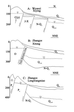
Fig.1 The simple hydrological sections
showing the hydraulic contact relationship between the
content and unsaturated zone
chemistry to obtain data on modern recharge rates and to determine recharge
history. These samples were taken to compare with the isotopic and chemical
compositions of the lakes and springs, as well as to compare the recharge
record as a proxy for climate, with that of the shallow lake sediments. Water
was extracted by elutriation. Samples were homogenised over sample intervals of
Estimations of groundwater recharge were carried out using the
chloride mass balance (CMB) technique (Allison and Hughes 1978; Edmunds et
al.1988). According to this simplified CMB approach the transport process for
chloride is assumed to be 1-D, downward piston transport, and the Cl input is
assumed to be constant at the surface. The age or residence time represented by
Cl can be evaluated by dividing the cumulative total mass of chloride from the
surface to that depth by the annual Cl input (
4
Results and Discussion
4.1. Recharge
Estimation from Unsaturated Zone Profiles
The chloride results obtained by elutriation for each hole are
presented in Fig. 2 as a function of depth together with
the moisture content. The oscillations of chloride show that the recharge rate
has not been constant. Chloride concentration has a mean value of 165 mg l
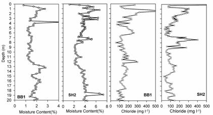
Fig.2 Moisture content and chloride concentration
for the unsaturated profile at the Badainmiao and Suhate sites
Values of Chloride in rainfall used are 1.5 mg l-1 and the mean annual rainfall of
4.2. Groundwater geochemical evolution
The TDS contents in the groundwater samples collected in the Heihe
river ranged from 293 mg l
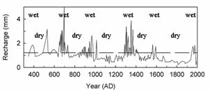
Fig.3
The recharge history and the climatic record information from unsaturated zone
profiles
8097 mg l
The groundwaters feeding Baoriletigai lakes have a neutral pH and
a total mineralisation in the range 720-1180 mg l-1 which is only slightly less than the
lakes (1340-1790 mg l-1). This suggests that little evaporation is
occurring and that these lakes are kept fresh by water continuously moving out
of the system towards the north (implied regional flow direction). The total
mineralisation at the nearby
Hydrochemical coefficients, expressed in epm, show the relative
concentration of various ions and can be used to indicate the predominance of a
particular ion and to define locations of salt water intrusion. The mNa/Cl
ratio in sea water is less than the unity(0.85), while groundwater has Na/Cl
ratios great than the unity. There for, it is used for indicating areas
suffering from salt water intrusion by fresh water. One significant
characteristic of the groundwaters is the very low mK/Na ratio of 0.017, which
would denote the dominance of albite over K-feldspars in the catchment area.
The mNa/Cl ratio in the aquifer of Heihe basin are variety between
0.64 to 3.85 and most of them are over 2, in the aquifer of Shiyang basin are
variety between 0.59 to 3.3 and most of them are over 1.5. The mNa/Ca has a
increasing trend along the groundwater flow from 1 to more than
4.3. Recharge
environment and groundwater age
Precipitation data are available for several meteorological
stations around the study area, including
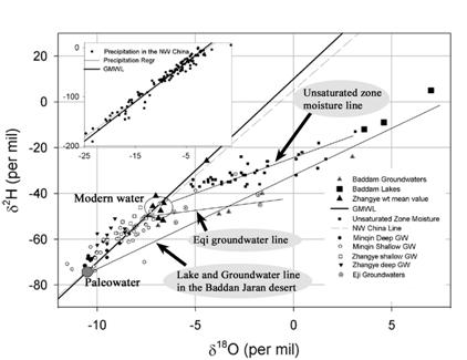
Fig. 4 Stable isotope rations in the
groundwaters of the Shiyang river,
The groundwaters in Zhangye basin and Ejina of the Heihe river
show a range from -40.6‰ to -62.‰ δ2H and –1.7‰ to –10.2‰ δ18O.The deep groundwaters in Zhangye basin has
the same isotopic composition with that in Minqin. The δ2H and δ18O values of the deep groundwaters
is significantly lighter than the shallow waters both in the Zhangye Basin and
Ejina Basin, which were slightly enriched in the heavy isotopes and has an
intercept on the Global Meteoric Water Line (WMWL) in the domain of modern
rainfall (–7‰ δ18O). It is concluded that the deeper waters in
both rivers are palaeowaters and that the shallower water with values between
–7‰ and –11‰ δ18O represent mainly palaowaters mixed with
limited modern recharge. The groundwaters in
Minqin basin of the Shiyang river show a range from -31.6‰ to -73.8‰ δ2H
and –7.14‰ to –11.54‰ δ18O. The deeper groundwaters (from depths of
200
The isotopic composition of the lakes and the shallow groundwaters
feeding the Baoriletigai and Lexiketu lakes in the Baddain Jaran desert show
strong evaporation and are interrelated along a line that intercepts the local
meteoric line at around -12‰ δ18O (Fig. 4). This implies that the
groundwaters and the lakes in the desert are genetically related and that these
are unrelated to modern recharge which has a weighted mean value lighter by
some 5‰ δ18O. The lakes and inflowing groundwatres therefore originate
as palaeowaters formed under a cooler climate and/or to a remote source rather
than modern recharge. In this context it is noted that the weighted mean
composition of modern high altitude precipitation at
Tritium has been used in many groundwater studies to determine the
residence time of groundwaters. Once 3H
enters the subsurface as meteoric water, it becomes isolated from the
influences of variable atmospheric 3H
concentrations. Concentrations of 3H
in the groundwater system depend primarily on the initial atmospheric
concentration at the time of recharge and the radiogenic decay that has
occurred since infiltration. In some cases, investigators have interpreted
approximate groundwater ages from 3H
concentrations. This requires that the initial precipitation 3H input record be known in
order to interpreted quantitatively the groundwater age from the pattern of 3H concentrations along the
groundwater flow path. In may regions of the world however, 3H precipitation data is
not locally available. It is necessary in these case to extrapolate data from
more distant locations.
The IAEA’s network of pluviometer in Zhangye is the only station
in the north
However, age determinations accurate to the year are impossible
and of no meaning to groundwater studies in the region according to the Fig.6.
For example, a groundwater with a 3H
value of 30-35 TU was possibly recharged by the precipitation in any of the 8
years: 1968-1971, 1986,1989,1992 and 1996. In addition, complicated mixing takes place in each
aquifer, and the mode and extent of mixing of each year’s recharge with that of
previous years recharge is unknown. However, semi quantitative dating is
possible and very informative. Groundwaters with no more than 0.5 TU tritium
has a pre-1952 age. Groundwater with significant tritium concentration (more
than 10 TU) is of post 1957 age. In this case, only 5 years the left tritium
may less than 20 TU. From the overall trend it is obviously concluded that
groundwater with a post 1957 age should have the tritium concentration more
than 20 TU. It is obvious that the majority groundwater collected in the
baddain Jaran dasert and Heihei rever has the 3H
values less than 10TU, and only 5 spring water sample in the Lonshoushan
Mountain and western part of the Baddain Jaran Desert has the tritium value of
20-30TU, indicative of the pre-1957 ages. It is challenged that Chen JS et al
(2003). have given an incomplete and misleading interpretation of the isotopic
data combined with an absence of hydrogeological conceptualisation. Hence, the
conclusion of modern deep groundwater flowing from the Qilian Mts to the badain
Jaran desert is unsound. The spring flow in the Baddain Jaran desert recorded
by Chen JS et al(2003) is likely to be maintained by palaeowater rather than
modern snomelt. Radiocarbon data are required to confirm the hydrogeological
model implied by isotopic data, but analogous results from a series study in
Arid Northern China (Chen JS et al., 2003), the Minqin Basin(Ma et al.,
5
Conclusion
Chloride has the advantage of simple analysis and of being
conserved during the recharge process so that a mass balance approach can be
used. A mean value of
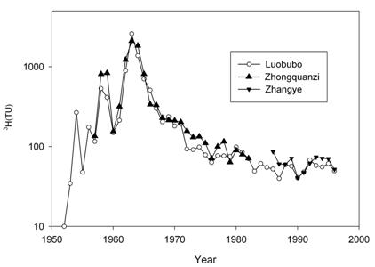
Fig.5 The reconstructed tritium value
from 1953 to
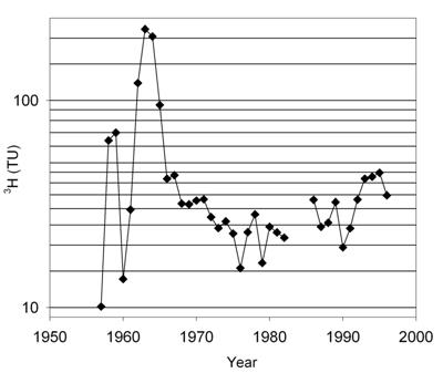
Fig.6 The decayed precipitation record
of 3H concentration in
groundwater that had infiltrated between 1957 and 1996.
of Cl--SO42
- is dominant. The lakes in
the Badain jaran desert are generally of fresh water, although with variable
compositions which suggest some in-basin biogeochemical modification.
Stable
isotopes (δ18O and δ2H) provide clear distinction between
modern and ancient waters. A good rainfall database from nearby Zhangye
provides definition of the composition of modern rainfall. The signature of groundwater from the
late Pleistocene differs markedly from that of the Holocene, shown clearly by
the stable isotopic compositions (around -10.5‰ δ18O as compared
with values of -7‰ at the present day). This primary difference is similar to
that observed by Chen Z et al. 2003 for the North China Plain near
It
is clear that tritium age determinations accurate to the year are impossible
and of no meaning to groundwater studies in the region due to tritium
measurements in the shallow unconfined groundwater environment could either be
influenced by vapour exchange with the soil atmosphere or an expression very
localised modern recharge. In addition, complicated mixing takes place in each
aquifer, and the mode and extent of mixing of each year’s recharge with that of
previous years recharge is unknown. A tritium value in the groundwater means
multiple recharge ages in this region. It is challenged that Chen JS et al.
(2004) given an incomplete and misleading interpretation of the tritium age.
Our results clearly show that modern direct recharge in this area
is negligible. In addition it is apparent that the groundwaters being
abstracted in the Minqin Basin, Ejina basin and feeding the lake system of the
Badain Jaran are part of a regional flow network related to a wetter past
climate as source of recharge. This system is largely decoupled from the river
network in this area. The recharge source in the past and to a limited extent
in the more arid conditions of the present day included the foothills of the
mountains of the Tibetan plateau.
Acknowledgments
The research is supported by the National Cooperation project
(Grant No. 2002CB714004), the National Science Foundation of China (No.
40302031) and NSFC Innovation Team Project (No.40421101). This work also forms
part of a wider UK-China collaboration and we acknowledge the support of the
Royal Society through its link scheme (PEK/0992/306).