


Achievements
CHARACTERISTICS OF GEOCHEMISTRY AND STABLE ISOTOPIC SHALLOW GROUNDWATER IN THE PEARL RIVER DELTA, CHINA
Yintao1, Tang Changyuan2, Chen Jianyao3, Sakura Yasuo4
1. Graduate School
of Science and Technology, Chiba University, Chiba,
263-8522
yintaolu@graduate.chiba-u.jp
2. Faculty of Horticulture, Chiba University, Chiba,
271-8510
3. Zhongshan University,
Guangzhou, 510275
4. Faculty of
science, Chiba University,
Chiba, 263-8522
Abstract: The Pearl River Delta region has its rapid economy development in past decades. In order to understand the characteristics of shallow groundwater and its use in this region, Hydrological surveyings have been carried out twice in 2005. Chemical compositions such as K+,Na+,Ca2+,Mg2+,NH4+,Cl-,SO42-,HCO3-,NO3- and stable isotope have been analyzed in laboratory of Chiba university. For simple, two typical areas, A and B, have been choosen to explained in this paper. The δ18O andδD ranged from –6.68 ‰to –3.76 ‰1, and –51.3‰ to - 27.5‰, respectively, and the d-excess of groundwater is lower than 15 ‰. Groundwater in study area is recharge by modern rainfall. Groundwater in A area indicates absence of significant evaporative modification during passage through the soil zone, and, groundwater in B area have undergone significant evaporation. The samples (about 40%) in the A area can be placed exactly into same type subgroup and the types are Na-Cl types and other samples can consider that they are Ca-HCO3 types. The samples in the B area can consider that it is Ca-HCO3 type. In A area, groundwater dissolves higher Na+ and Cl-, it is considered that storm bring salinity of sea and then recharge into groundwater. In the PRD, the linear relationship between Cl- and SO42- was: [SO42-] = 1.38 [Cl-] + 1.4, except the points that ware polluted by wastewater of landfills. Cl- concentration in part B area is higher due to the pollution of wastewater.
Keywords: the Pearl River Delta, Groundwater, Stable
Introduction
The Pearl River Delta (PRD) is one of the most
developing regions even in Asia, in which
there are 8 main cities,
namely, Dongguan, Foshan,
Stable isotope and chemical techniques are important to determine the origin of groundwater in aquifers and the dominant geochemical reactions responsible for surface and groundwater quality in this kind of environment. The isotopic compositions of O and H in water modified by meteoric processes are useful traces for determining groundwater origin and movement (Marfia et al, 2004). Stable isotopes of O and H are particularly useful as traces because the isotopic composition of O and H in groundwater does not change as a result of rock-water interactions at low temperatures (e. g. Sidel, 1998). In addition, isotope techniques are of particular importance when examining fracture flow patterns (Rose et al., 1996) or areas with a scarcity of wells (Scholl et al., 1996). Geochemical methods are commonly applied to study groundwater flow regimes (Freeze and Cherry, 1979). Chemical processes may provide evidence for groundwater flow. When stable isotopes and geochemical data are examined for both surface water and groundwater systems, important information about processes related to water cycling and rock-water interaction that may affect water quality are readily discernable (Marfia et al, 2004).
This study was conducted to understand hydrogeologic process governing water quality at the PRD. Based on the results of field survey and geochemical analysis, authors focused their attentions on: (1) clarify of origin of groundwater from stable isotopes (18O and D) measurements; (2) clarify of groundwater flow system from measurements of chemical compositions; and (3) evaluate the groundwater pollution caused by human activities through analyzing changes of nitrate and ammonium concentrations.
Site descriptions
The Pearl River Delta, located at
111º30’E–116ºE and 21º30’N–23º40’N, is an alluvial plain covering
approximately 26,820 km2. The PRD is situated in a transitional zone of the East Asian monsoon system, where the southwesterly summer monsoon comes from the South China Sea and tropical Pacific oceans, while the northeasterly winter monsoon comes from Mainland
At the time of the last glacial maximum, the seaward margin of the ancient Pearl River Delta was located at the position of the present-day outer continental shelf, about 100-130 m below today's sea level (Li, 1986). Transgression occurred due to the postglacial sea level rise. The landward shift of the coastline resulted in markedly retrogressive aggradation in the drowned valleys of the ancient Pearl River. This can be confirmed by a fining-upward sedimentary sequence commonly found within the delta area (Qiao, 1980; Li, 1986; Zhen and Huang, 1987). After the rising sea level eventually terminated at about 3000 BP, seaward accretion, which replaced retrogressive aggradation, has been relatively rapid. Apart from any highly fluvial input, the bedrock islands lying discontinuously across the mouth of the Pearl River estuary might also have an effect on retarding fluvial sediment from moving out of the estuarine basin. In response to rapid vertical accretion, the deltaic surface has also expanded seawards rapidly. In fact, the relatively shallower depth of the estuarine basin and numerous bedrock islands, which account for about 20% of the total area of the estuary, further contributed to the rapid siltation of the estuarine embayment (Lin and Melville, 1994).
The modern Pearl River Delta
has developed on the previous Pearl River
estuarine embayment as a consequence of the last postglacial sea level rise
(Qiao, 1980; Li, 1986; Zhen and Huang, 1987). Previous soil investigation (Lu
et al., 1988) shows that the acid sulphate soils of the area are primarily
distributed in the southwest and the northeast parts of the delta. The sediment
in the southwest part mainly derives from the
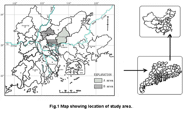
The above-mentioned development and deposition processes of the Pearl River Delta result in various landform. In view of characteristics of geological, the study area are classified as A area and B area (Fig. 1).
A area
A area is located at 113º50’E–114ºE and 23º5’N–23º30’40”N, the northeast
of
B area
B area is located at the north of Guanghua Plain with the average elevation about 20 m above sea level. It is descending from north to southwest. Guanghua Plain formed in a long time ago. There are lots of flats and hills from northeast to southwest. The sediment layers are mainly sand and clay. Sometimes hardpan can be found. The limestone layer of Permian Period is laid the sediment layer. Plenty of groundwater resource are used for agriculture, industry and drinking.
Material and Methods
Hydrological surveyings were done twice in 2005. Shallow groundwaters were taken from inhabitants wells with depth of 1 m to 12 m. Samples were brought back to the Laboratory in Chiba University to analyze the major ion concentrations, as well as stable isotopes (δD and δ18O).
Concentrations of K+,Na+,Ca2+,Mg2+,NH4+、Cl-,SO42- and NO3- were analyzed by ion chromatography (Shimazu CTO-10A) and stable isotopes (18O and D) by mass spectrometer (Finnigan MAT Delta S), respectively. The analytical precisions for all cations and anions are 2%. For oxygen isotopic analysis, about 10 ml of each groundwater sample was equilibrated with CO2 by shaking for 6 hours at 25oC. For hydrogen isotopic analysis, metallic zinc was used to produce hydrogen gas in the zinc-reduction method (Coleman et al., 1982). The analytical reproducibility is ±0.1‰ for δ 18O, and ±1‰ for δ D, respectively.
Oxygen-18 and deuterium abundances are expressed as ratios in delta
notation (δ) as per mil differences relative to the standard know as
![]()
(1)
where, Rsp and Rst is the ratios for D/1H or 18O/16O in the sample or standard respectively.
Results and Discussions
Mean precipitation and stable isotope in precipitation
Fig. 2 shows the mean monthly precipitation in the Pearl River Delta region. Most precipitation is available during April to September. Accordingly, the most monthly precipitation is 422.3 mm in May, the second is 250 mm in July and August, the typhoon season in the study region. From October to February of the next year, the Pearl River Delta is in the dry period. The least monthly precipitation is found as 30 mm in February.
The values of stable isotopes of δ18O andδD show the asymmetry distributions with month (Fig.3). The lightest values were found in July and δ18O andδD is -7.67‰ and -56‰, respectively. The values of δ18O andδD were heaviest in April with –3.6‰ and –15.7‰, respectively. Theδ18O andδD values from summer rainfall are lower than that from winter rainfall.
Stable isotopes in groundwater
Stable isotopes of water are excellent tracers for recharge of surface water to groundwater (Craig et al. 2002). Oxygen-18 and deuterium are naturally occurring stable isotope of oxygen and hydrogen (John
A. 2002). Because th e most of the world’s precipitation is from evaporation of seawater, theδ18O
andδD composition of precipitation throughout the world is linearly correlated. This relation is known as the global meteoric water line (GMWL) expressed as δD=8δ18O+10 (Craig 1961).
Tracing of groundwater in the Pearl River Delta region has a good corresponding relation with stable isotope such as 18O and dD (Fig. 4). The δ18O andδD composition at the A area ranged from –6.68 ‰to –4.3 ‰, and –50.9‰ to - 27.5‰, respectively (Fig. 4). The δ18O andδD composition at the B area ranged from –6.3‰ to –3.76‰ and –51.3‰ to –31.2‰,
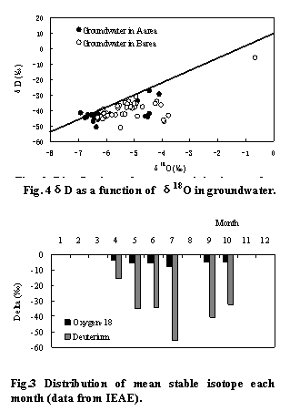 |
respectively (Fig. 4). From theδ18O /δD
diagrams (Figs 4) it can be seen that in most cases the groundwater fall on or
close to the GMWL, showing that these samples have not been subjected to
significant evaporation before or during infiltration into the aquifers. This
suggests that storm water infiltrates rapidly throughout fractured zones of the
rocks and the highly permeable deposits in the recharge areas of the study
area. To get the recharge time of groundwater, C(δ18O,δD), of the weighted mean value was used:
(2)
Where pi is the precipitation amount corresponding to each month and di is the meanδ18O or meanδD corresponding to each month in precipitation. The C ofδ18O andδD in precipitation is -5.53‰ and -37.1%, respectively (Fig 2 and Fig. 3). The values are closed to precipitation during May and July, implying that only precipitation during May and July can recharge to groundwater.
A few points, especially those located in B area show relative deviation from the isotopic composition of the rainfall. This probably indicates that the infiltrating rain water undergoes some evaporation while passing through the soil zone and, as a result, the residual descending water gets slightly enriched in the heavy isotopes. However, the groundwater are isotopically depleted compared to the rainfall in winter season, but they are closed to the composition of rainfall storms observed in summer season (Figs2 and Fig. 4). This in fact implies that the local recharge is produced mainly by summer rainfall.
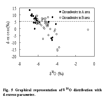
d-excess
Dansgaard (1964) defined the
d-excess (d=δD-8δ18O), which is used to identify the origin of the vapour masses producing
rainfall. Considering the d-excess values obtained for precipitation and
groundwater , as shown in Table 1, it isevident that most of the values are
close to or less than 10‰. The precipitation are mainly
characterized by relatively low d-excess (d=6.5). The low d-excess values of
precipitation can be attributed to the unusually high proportion of the warm
period (May to October) for the local climatic conditions or due to evaporation
of raindrops under the cloud base. d-excess of groundwater is lower
than that in precipitation, the possibility of the rainfall being an effective
factor in the recharge process of the groundwater aquifers of the area, may be
admitted. In Fig. 5, note that samples with d-excess < 5 ‰ are relatively
enriched. This suggests that these samples have undergone significant
evaporation. The regression line slope of samples with d-excess between 5 and
15‰ lies close to the GMWL. This may indicate absence of significant
evaporative modification during passage through the soil zone.

The characteristics of geochemistry in groundwater
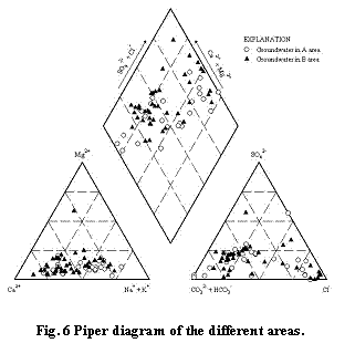
Most of the graphical methods are designed to simultaneously represent the total dissolved solid concentration and the relative proportions of certain major ionic species (Hem 1989). All the graphical methods use a limited number of parameters, usually a subset of the available data, unlike the statistical methods that can utilize all the available parameters (Cüneyt Güler、2002). The piper diagram (Piper 1944; Fig. 6) is the most widely used graphical form and it is quite similar to the diagram proposed by Hill (1940, 1942). The diagram displays the relative concentrations of the major cations and anions on two separate trilinear plots. The points of the central diamond are from the two trilinear plots. The central diamond-shaped field is used to show overall chemical character of the water (Hill 1940; Piper 1944).
An area can be placed exactly into same type subgroup
and the types are Na-Cl types and other samples can consider that they are
Ca-HCO3 types. The samples in the B area can consider that it is
Ca-HCO3 type.
Ionic Relationships in the Study Area
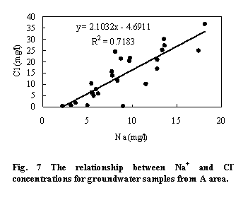
A plot Cl- vs. Na+ for the groundwater samples in A area are shown in Fig. 7. Groundwater samples had concentrations of Cl- between 0 and 38 mg/l and Na+ between 2 and 18 mg/l respectively. Groundwater samples show a clustering of data at low Cl- and Na+ values and the relationship of Cl- and Na+ values for all samples can be expressed in [Cl-] = 2.1 [Na+] – 4.69. Cl- and Na+ are primary components of sea water, and Cl- concentration is slightly higher than Na+. Its relationship can be expressed in [Cl-] =1.18[Na+] (the unit of Cl- and Na+ concentration is mol/l) in sea water, so if unit is exchanged to mg/l, [Cl-] should be 1.82[Na+]. As a result, the slope of 2.1 for groundwater samples in A area is close to with [Na+]/ [Cl-] of sea water. It indicates that groundwater samples are influenced by sea water in the study area. As a result, it is considered that storm bring salinity of sea and then recharge into groundwater.
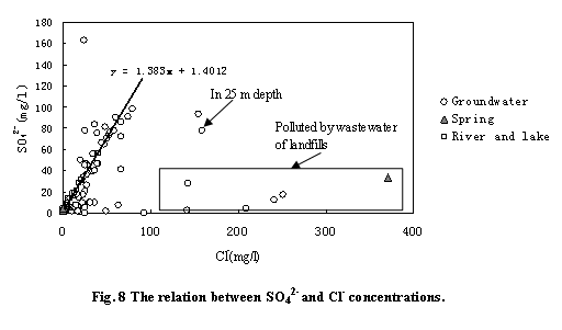
Cl- and SO42- are usual ion from nature environment. Because effect of human activity, Cl- show higher value than nature environment. Positive relationship between Cl- and SO42- is shown in Fig. 8 with a ratio Cl-/ SO42- of about 0.7 in the PRD. The linear relationship between Cl- and SO42- is: [SO42-] = 1.383[Cl-] + 1.4012 except those points that are polluted by wastewater of landfills. Wide change and high Cl- and SO42- concentration are found in the study area. The concentrations of Cl- and SO42- in the river and lake are found to have a same change with groundwater and change 4-40 mg/l and 6-57 mg/l respectively. Low Cl- and SO42- concentrations in the spring are found to change 0-6 mg/l and 2-7 mg/l respectively except some points that are polluted by wastewater of landfills.
Conclusions
An isotopic and chemical analysis of the surface waters and ground waters was carried out to understand the groundwater flow system and geochemical processes governing water quality in the Pearl River Delta affected by Asian monsoon. The relationships between δD and δ18O for groundwater were similar to rainfall, and the d-excess of groundwater is lower than 15 ‰. Groundwater in study area is recharge by modern rainfall. There is a little difference between A area and in B area. Groundwater in A area indicates absence of significant evaporative modification during passage through the soil zone and in B area, groundwater have undergone significant evaporation.
The samples are classified into two dominant water types including Ca-Cl and Ca-HCO3 types. The samples (about 40%) in the A area can be placed exactly into same type subgroup and the types are Na-Cl types and other samples can consider that they are Ca-HCO3 types. The samples in the B area can consider that it is Ca-HCO3 type. In A area, groundwater dissolves higher Na+ and Cl-, it is considered that storm bring salinity of sea and then recharge into groundwater.
We can establish source of chemical composition using chemical technique. In the PRD, the linear relationship between Cl- and SO42- was: [SO42-] = 1.38 [Cl-] + 1.4, except the points that ware polluted by wastewater of landfills. Cl- concentration in part B area is higher due to the pollution of wastewater.
Acknowledgements
This study is supported by Grant-in-Aid for Scientific Research of Japan Society for the Promotion of Science (no.16651004, no.18300312) and national natural science foundation of china (40571027); 985 project (no.105203200400006).
References
[1] Cao J.J., Lee S.C., Ho K.F., Zou S.C., Fung K., Li Y.,
Watson J.G. and Chow J.C.. 2004. Spatial and seasonal variations of atmospheric
organic carbon and elemental carbon in Pearl River Delta Region,
[2] Chau KW, Jiang YW, 2002. Three-dimensional pollutant transport model for the Pearl River Estuary. Water Research 36 (2002) 2029–2039
[3] Cheung KC, Poon BHT, Lan CY, Wong MH. 2003. Assessment of metal and nutrient concentrations in river water and sediment collected from the cities in the Pearl River Delta, South China. Chemosphere 52: 1431–1440
[4] Craig H, 1961. Isotopic variation in meteoric waters: Science 133. 1702-1703.
[5] Craig T. simmons, Kumar A. Narayan, Juliette A.
woods, Andrew L. Herczeg,2002. Groundwater flow and solute transport at the
Mourquong saline-water disposal basin, Murray
Basin, southeastern
[6] Cüneyt Güler,Geoffrey D. Thyne, Tohn E. McCray, A. Keith Turner (2002) Evaluation of graphical and multivariate statistical methods for classification of water chemistry data. Hydrogeology Journal Pap 10: 455-474 pp
[7] Dansgaard, W. (1964). Stable isotopes in precipitation. Tellus, 16: 436}468.
[8] Freeze, R.A., J.A. Cherry. 1979. Groundwater.
Prentice Hall Inc.,
[9] Guangdong Provincial Coast Zone Resource
Comprehensive Survey Office (GPCZRCSO), 1986. Research collected works of the
resource comprehensive survey in Pearl River estuary and Guangdong Provincial
Coast Zone Guangdong Technology Press,
[10] Hem JD (1989) Study and interpretation of the
chemical characteristics of natural water, 3rd edn.
[11] Hill RA (1940) Geochemical patterns in
[12] Gonfiantini R, 1978. Standards for stable isotope measurements in natural compounds: Nature 274.534-536.
[13] John A. Izbicki, John Radyk, Robert L. Michel (2002) Movement of water through the thick unsaturated zone underlying Oro Grande and Sheep Creek Washes in the western Mojave Desert, USA. Hydrogeology Journal 10:409-427.
[14] Li, C., 1986. Deltaic sedimentation. In: M. Ren
(Editor), Modern Sedimentation in Coastal and Nearshore Zones of
[15] Lin C., Melville M.D. 1994. Acid sulphate
soil-landscape relationships in the Pearl River Delta, southern
[16] Lu, F., Zhu, S., Lu, J., Yuan, C., Liu, K., Deng,
B., Li, M., Shen, D., Lu, L., Luo, L., Lin, S., Zheng, H., Zhang, B., Zhong,
S., Yuan, H., Tang, S., Huang, S., Cheng, R., Qin, X., Yang, P. and Yang, Y.,
1988. Soils in the Pearl River Delta.
[17] Marfia A.M., Krishnamurthy R.V., Atekvana E.A.,
Panton W.F., 2004. Isotopic and geochemical evolution of ground and surface
waters in a karst dominated geological setting: a case study from
[18] Ouyang Tingping, Kuang Yaoqiu, Tan Jianjun, Guo
Guozhang,Gu Lisong (2004) Spatial distribution of trace element in rivers in
the Pearl River Delta Economic Zone. Hydrogeology and Engineering geology (
[19] Piper AM (1944) A graphic procedure in the geochemical interpretation of water analyses. Trans Am Geophys Union 25:914-923
[20] Qiao, P., 1980. Evolutionary processes of the Pearl River Delta. People's Pearl River (in Chinese), 2: 40-50.
[21] Rose, T.P., M.L. Davisson, R.E.Criss. 1996. Isotope
hydrology of voluminous cold springs in fractured rock from an active volcanic
region, northeastern
[22] Scholl, M.A., S.E. Ingebritsen, C.J. Janik, J.P.
Kauahikaua. 1996. Use of precipitation and groundwater isotopes to interpret
regional hydrology on a tropical volcanic island: Kilauea volcano area,
[23] Sidle, W.C. 1998. Environmental isotopes for resolution of hydrology problems. Environ. Monitor. Assess. 52:389-410.
[24] Young, P., 1995. Bordering on a crisis, South China Morning Post, 14 January, Hong Kong.
[25] Zhen, Z. and Huang, S., 1987. The Studies on the Historical Geomorphology of the Pearl River Delta. Higher Education Press, Guangzhou (in Chinese)