


Achievements
DEVELOPMENT AND UTILIZATION PROSPECT OF GROUNDWATER RESERVOIR IN CIRCUM-BOHAI-SEA REGION
Sun Xiaoming1,2 , Wang Weidong3 ,Xu Jianguo4 ,Yang Qiqing2 ,Du Dong2 ,Xing Zhongxin5
1 School
of Water Resource and Environment, China University
of Geosciences, Beijing 100083,
2 Tianjin
Institute of Geology and Mineral Resources, Tianjin
300170,
3 Liaoning
Exploration Institute of Hydrogeology and Engineering Geology, Dalian
116037,
4 Shandong
Institute of Geological Survey, Jinan 250013,
5 The Fourth Team of
Hydrogeological and Engineering Geology, Hebei Bureau of Geo-exploration,
Cangzhou 061000,
Abstract: The feasibility of building
groundwater reservoir is analyzed in Circum-Bohai-Sea region of
Keywords: Circum-Bohai-Sea; groundwater reservoir; feasibility; development prospect
1 Introduction
There are water resources quantities of 660m3 perperson in Circum-Bohai-Sea region
where is one of the most shortage of water resources places in
2 The Feasibility of Building Ground-water Reservoir
The experience of groundwater reservoir construction in the world show that building groundwater reservoir is a complicated systemic project.Because many factors must be considered when building groundwater reservoir, such as hydrology, geology, environment, social and economic condition and so on [2-5].
2.1The condition analysis of building ground-water reservoir
2.1.1 Recharge water source condition
The precondition of building underground reservoir is that have enough
recharge water source in the region. Intercepting the local surface runoff is
main recharge water source from the groundwater reservoir having been built
inside region. The mean annual average runoff is 74.23´108m3 and 66.08% of runoff flow
into the sea in eastern Jiao. The interception ratio of surface runoff is only
from 8.1% to 10% and most of the runoff change into abandoned water in northern
2.1.2 Hdrogeological condition
Water-storing space and regulation condition of water are the basic hydrogeological conditions of building reservoir. Conditions of building reservoir are as following: the thick aquifer thickness, coarse grain in aeration zone and aquifer, without widespread aquitard distributing, good infiltration condition, strong capacity of water storage or water supply, good water transmissibility, relative shallow burial depth of aquifer. Especially, the regions of alluvial fan and river valley where groundwater and river have close relationship between recharge and discharge have more value in groundwater reservoir development and utilization. The other important factor of building reservoir is water intake condition. That demands strong permeability of aquifer and big yield of single well. According to hydrogeological conditions and need of water supply and experience of engineering in Circum-Bohai-Sea region, critical hydrogeological conditions which are preliminary determination of selecting groundwater reservoir in littoral region are as following: the thickness of aquifer is more than 5 meters, and specific yield is more than 0.15, and permeability is more than 20m/d, and yield of single well is more than 500m3/d.
In littoral region of Liaodong peninsula, usual thickness of Quaternary is 5-20m distributing along cleuch. Main lithology of aquifer are grit stone, egg stone and medium coarse sand and so on. Permeability coefficient is 20-150m/d. The specific yield is 0.15-0.3. Yield of single well is 500-3000m3/d and the maximum is 5000 m3/d; in littoral region of Liaoxi mountain country, usual thickness of Quaternary is 10-20m distributing along cleuch. Yield of single well is 1000-3000m3/d and the maximum is more than 5000 m3/d; In littoral valley region of Jiaodong peninsula, Main lithology of aquifer are grit stone, medium fine sand and thickness of aquifer is 3-10m. Yield of single well is 500-4000m3/d. Permeability coefficient is 10-50m/d. Specific yield is 0.15-0.3. The condition of storage water in littoral valley region is good, and only discharge channel is entrance of river, where formed independent hydrogeological unit.
There are many piedmont alluvial and flood fans distributing around Xialiaohe plain. Burial depth of groundwater level is usual 2-10m.Main lithology of aquifer are gravel, pebble and medium-coarse sand. The thickness of aquifer is 10-80m. Specific yield is 0.2-0.3. Permeability coefficient is 90-300m/d. Yield of single well is 3000-10000m3/d. At present, most water sources region of cities centralize here, and local depress cone of groundwater level is formed, so here is a very suitable place to build groundwater reservoir.
In intermontane valley plain region of Jiaodong peninsula, thickness of aquifer is 2-20m.lithology is medium-fine sand, gravel. Permeability coefficient is 30-300m/d. Specific yield is 0.15-0.26.Yield of single well is more than 1000 m3/d.
The main lithologies of piedmont alluvial and flood fans in east of
The main lithologies of piedmont alluvial and flood fans in south central of Shangdong province are coarse sand, pebble. The thickness of aquifer is 10-30m. Permeability coefficient is 50-100 m/d. Specific yield is 0.1-0.3.Yield of single well is more than 1000 m3/d as usual, and more than 3000 m3/d at the axes of fan.
Distribution of shallow fresh water aquifer in Middle East of North China Plain is controlled by old stream, and has zonal distribution. The main lithologies are fine sand, silt, and partial place is medium sand. There are 7 old streams in Huangfan plain. Width of stream channels is 2-13km. The gravel thickness of ancient river course zone is generally more than 10m. Yield of single well is more than 500 m3/d. Artificial recharge in ancient river course zone is convenient to combine ancient river course zone with existing stream and water-carriage system.
2.1.3 Landform and physiognomy condition
The reservoir address of planning choice should have enough surface storage water space and even landform so that providing enough times for penetrating of surface water. So they are perfect area of building groundwater reservoir in alluvial and flood fan, inermountane river valley plain, coastal river valley, ancient river course zone of alluvial plain and so on. We should make the best of the underground reservoir capacity that is formed of the modern river course, ancient river course, tunnel, channel and descent funnel of groundwater table. Because it can be used to regulate rain, flood and river water and implement the associated regulating of surface water and groundwater.
2.1.4 Environmental geology condition
It requires better geo-environmental status for choosing reservoir address area. The groundwater development is advantageous to improving geology environment and reducing geology disaster. Meanwhile, it requires small population density and no pollution substance around reservoir. The current quality of surface and ground water is accord with correlative sanitation standard, although the current water quality is very poor, the water quality status will improve gradually after the underground reservoir is operated.
It has formed groundwater table descent funnel due to exploit the ground
water chronically in alluvial and flood plain and coastal plain of coastal
river valley in eastern
Although it has formed groundwater funnel due to over exploiting of
groundwater in before mountain plain of eastern
It distributes a big salt-water area in Middle Eastern region of north
A great deal of salt is brought by a long period irrigation, so it leads to the further salty of groundwater. Due to distributing many ancient river courses inside area, it can through constructing underground reservoir to regulate water resources artificially so that promoting groundwater circulation, improving groundwater quality, preventing and curing salt basification of soil. Development and utilization practicing of shallow layer salt water and tiny salt water in Nanpi of Henan province show that it can desalt the tiny salt water of shallow layer into freshwater about 15 years [9] through depressing underground water level, vacating underground reservoir capacity, and forming a continuous circulate progress that making use of certain engineering means to speed the seasonal flood seeping, recharging, desalting gradually.
The exploitation intensity of groundwater is very great in alluvial and
flood plain area before the mountain of middle southern
2.2Eco-environmental effects of ground-water reservoir
2.2.1 Interception of surface runoff
The source of surface runoff is short and urgent in the river valley of
littoral low hill knap and the rainstorm and onrush mostly flow into the sea.
There are surface runoff quantity of 119.12´108m3 discharged into the sea in littoral
region of Liaoning and Shandong only in 2002.So, it will has important
realistic meaning for solving the shortage of water resources in the littoral
region if we make the best of the regulating function of aquifer and
intercepting the runoff quantity of flowing into the sea. For example, The
groundwater reservoir in Huangshui
2.2.2 Protecting wellhead places and increasing the allowable exploitation quantity of groundwater
The coastal river valley is main sector with abundant water of low hill knap area where have many water source places. It appears exploitation funnel, inducing seawater invasion and controls the water supply of wellhead place because the surface runoff of upriver is intercepted and the recharge quantity of groundwater is decreased. The wellhead places will be protected and the allowable exploitation quantity of groundwater will be increased if the groundwater reservoir is built in the sector with abundant water resource. It will enhance the allowable exploitation quantity of groundwater of 2.84´108m3 and will increase by 75.7% .The profit of increasing water resources is very evident.
2.2.3 Regulating river water resources
The regulation of water quantity will contradict with the need of water resources in the distribution of times after the project of regulating water is built and circulated. It cannot realize the equilibrium distribution of water resource quantity only by existing surface reservoir. So, the ground aquifer is used as a sluice space. For example, there are 8 big reservoirs, but their capacities only occupy 54.3%[10] of the capacities of 14-groundwater reservoirs built along the line in Xiashan, Wangwu, Menlou, Muyu, Cihongtan where included in the matching project of South-north water transmission and west-east water transmission project in Shandong. So, it is a realistic choice of using water resources effectively that making best of the sluice function of groundwater reservoir when regulating water resources over drainage basin.
2.2.4 Preventing and curing the environmental geological problems and improving the eco-environment
There are many problems of environmental geology such as sea (salt) water invasion, ground sedimentation, descent funnel of groundwater table, groundwater pollution and so on in Circum-Bohai-Sea region. Most of the problems are solved through building groundwater reservoir and regulating and controlling the groundwater table. Building underground purdah project can cure the seawater invasion radically; The groundwater reservoir project have many merits such as not bringing reservoir evoked earthquake, small evaporation and consuming and better water quality protection condition [11]. But the underground purdah project interdicts with the circle alternation of downstream groundwater around reservoir. So the self-clean ability of aquifer system around reservoir is decreased. Once the groundwater resources are polluted, it will be cured difficultly. Therefore, we must do better the task of curing pollution of around reservoir and upstream.
2.3 Economic profit of groundwater reservoir
The groundwater reservoir increased the supplying quantity of water
resources and it was also a tremendous economic profit as an industry of water
supply. The cost of per ton water only occupy from 1/3 to 1/2 of the cost of
project of per ton water when build the surface water reservoir according to
the project cost analysis of groundwater reservoir having been built in Dalian
city. It will enhance the allowable exploitation quantity of groundwater of
1.25´108m3
if 22 groundwater reservoirs of coastal river valley type are built. If they
are used to urban water supply, their production value will be from 0.22 to
0.33 billion Yuan and solve the problem of shortage water resources in
In conclusion, there will be a series of merits, such as not impropriating glebe, short period, lower project cost, stronger ability of regulating water resource, preventing seawater invasion, enhancing effect supply ability of water resources and controlling flood ability if these groundwater reservoirs are constructed. So building groundwater reservoir is an important choice that implementing the strategy of sustainability development in Circum-Bohai-Sea region.
3 Analysis of Groundwater Reservoir types and Development and Utilization Prospect
The groundwater reservoir can be compartmentalized into four types (see fig.1): coastal river valley type, inermountane river valley type, alluvial and flood fan type and ancient river course of alluvial plain type according to the environmental geological condition of building groundwater reservoir in the region. The coastal river valley type is distributed in eastern Liaoning, eastern Shandong peninsula and mountainous region of western Liaoning; The inermountane river valley type is distributed in river valley zone of inermountane lake basins in eastern Shandong; The alluvial and flood fan type is mainly distributed in alluvial and fan top of front mountain in around of Liao river plain, eastern Hebei and middle part of Shandong; The ancient river course of alluvial plain type is mainly distributed in Hai river basin plain and yellow river flood field.
3.1 The groundwater reservoir of coastal river valley type
The two outstanding characteristics of the groundwater reservoir of coastal river valley type are that they distributed in evoked seawater invasion area due to exploiting the groundwater and had double profits of increasing water resources and preventing the seawater invasion. When building this kind of groundwater reservoir, it should be designed into the groundwater reservoir with dam. The project is usually composed of intercepting water to recharge water source, taking water, curing pollution and the system of management and surveying. But considering the compositive development and utilization of water resources in the whole coastal river valley area, the perfect model is that planting tree and forestation and constructing green reservoir in upriver of valley, constructing the surface reservoir in middle river of valley and building underground reservoir in downriver of valley [14]. At present, there are 43 underground reservoir seemly addresses of building the groundwater reservoir of coastal river valley type in Circum-Bohai-Sea region (see table 1). It shows that from table 1 the newly enhanced allowable exploitation quantity of groundwater is more than 30% through building the underground reservoir in every valley area. For example, it is 1.39´108m3 in eastern Liaoning and even amplitude is 80% and these water resources quantities are equivalent to 64% of current water supply in Dalian; It is 0.84´108m3 in western Liaoning and even amplitude is 176% and can satisfy the water resource demand in Hulu island in 2010.It is 1.75´108m3/a in eastern Jiao peninsula and even amplitude is 54% and can provide the water supply source of 22-67% for Qingdao ,Yantai and Weihai in 2010.At present, the underground reservoir capacity of having been built is 7.03´108m3 and newly increase the groundwater allowable exploitation quantity of 1.15´108m3. The underground reservoir capacity built seemly is 28.85´108m3 and newly increase the groundwater allowable exploitation quantity of 2.60´108m3.
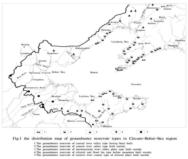
Table 1 The estimate of development and utilization prospect of groundwater reservoir of coastal river valley type in Circum-Bohai-Sea region
|
Physiognomy types |
The names of groundwater reservoir |
The area of water reservoir (km2) |
The thickness of aquifer(m) |
The capacity of water reservoir(104m3) |
The allowable exploitation quantity(104m3/a) |
New exploitation quantity(104m3/a) |
Remark |
|
Coastal river valley area in eastern |
Groundwater reservoir in Daqing river |
165.0 |
5.0-45 |
42075 |
2688.2 |
717.2 | |
|
Groundwater reservoir in Xiongyue river |
78.5 |
3.7-35.7 |
20488.5 |
2825.1 |
635.1 | ||
|
Groundwater reservoir in Fudu river |
61.5 |
3.0-20.0 |
10465 |
1557.6 |
524.0 | ||
|
Groundwater reservoir in Dijiao river |
9.5 |
1-8 |
513 |
240.8 |
120.8 | ||
|
Groundwater reservoir in Huli river |
64.5 |
1.5-10 |
4412 |
1514.8 |
912.3 | ||
|
Groundwater reservoir in Yingna river |
59.0 |
2-10 |
5310 |
2716.4 |
1869.6 | ||
|
Groundwater reservoir in Zhuang river |
87.5 |
2-8 |
7560 |
2345.8 |
1068.3 | ||
|
Groundwater reservoir in Biliu river |
120 |
3-8 |
9720 |
2853.3 |
1320.3 | ||
|
Groundwater reservoir in |
205 |
2-15 |
23985 |
3873.2 |
1099.2 | ||
|
Groundwater reservoir in Hongya river |
35 |
2-8 |
2205 |
493.7 |
373.7 | ||
|
Groundwater reservoir in Weitao river |
40.5 |
1-10 |
2187 |
702.5 |
470.5 | ||
|
Groundwater reservoir in Yongning river |
22.0 |
1-8 |
1386 |
472.5 |
87.5 | ||
|
Groundwater reservoir in Zanzi river |
42.5 |
1-7.5 |
2677.5 |
887.6 |
285.3 | ||
|
Groundwater reservoir in Anzi river |
13.5 |
1-7 |
850 |
275.7 |
170.7 | ||
|
Groundwater reservoir in Qingshui river |
22.5 |
1-8 |
1575 |
699.0 |
242.7 | ||
|
Groundwater reservoir in Dasha river |
172.5 |
3-15 |
18975 |
3151.8 |
1618.8 | ||
|
Groundwater reservoir in Dengsha river |
45 |
3-8 |
4050 |
1004.2 |
148.2 | ||
|
Groundwater reservoir in Qigan river |
18.5 |
3-8.2 |
1850 |
371.2 |
288.3 | ||
|
Groundwater reservoir in Qingyun river |
14.8 |
4-8 |
817.99 |
595.48 |
471.68 |
Programmed | |
|
Groundwater reservoir in Sanshilipu river |
39.5 |
3-15 |
4225 |
1272.4 |
822.8 | ||
|
Groundwater reservoir in Jianbao river |
26.09 |
1-15 |
614.2 |
500.0 |
447.5 |
Built | |
|
Groundwater reservoir in Longwangtang river |
0.96 |
1.0-8.1 |
74.85 |
70.14 |
48.14 |
Programmed | |
|
Groundwater reservoir in Long river |
8.5 |
0.8-5.7 |
86.5 |
127.75 |
127.75 |
Built | |
|
Groundwater reservoir in Sanguanmiao river |
1.94 |
0.8-13.0 |
63.81 |
41.01 |
24.38 |
Built | |
|
Subtotal |
1354.29 |
166355.31 |
31280.18 |
13894.75 | |||
|
Coastal river valley area in mountainous region of
western |
Groundwater reservoir in Xincheng river |
69.4 |
1.7-18.7 |
13446.94 |
2190.0 |
547.5 | |
|
Groundwater reservoir in Liugu river |
186.0 |
3.1-37.5 |
57438.76 |
8690.48 |
6351.0 | ||
|
Groundwater reservoir in Gou river |
73.0 |
5.0-20.0 |
10116.2 |
1086.46 |
961.0 | ||
|
Groundwater reservoir in Shi river |
48.5 |
2.0-12.5 |
4801.5 |
704.5 |
320.0 | ||
|
Groundwater reservoir in Yantai river |
39.40 |
2.7-12.1 |
7772.83 |
547.5 |
245.0 | ||
|
Subtotal |
416.3 |
93576.23 |
13218.94 |
8424.5 | |||
|
Coastal river valley area in eastern |
Groundwater reservoir in Wang river |
66.4 |
2-12 |
5246 |
1712 |
320 |
Built |
|
Groundwater reservoir in Balisha river |
0.7 |
4-6 |
43 |
62 |
44 |
Built | |
|
Groundwater reservoir in Zhongcun river |
38.7 |
5-15 |
9172 |
2000 |
500 | ||
|
Groundwater reservoir in Huangshui river |
51.8 |
10-30 |
5289 |
4514 |
2426 |
Built | |
|
Groundwater reservoir in Nanwang river |
6.2 |
10-15 |
920 |
670 |
181 | ||
|
Groundwater reservoir in Pingchang river |
28.0 |
14-23 |
5540 |
1698 |
718 |
Programmed | |
|
Groundwater reservoir in Dagujia river |
63.3 |
5-40 |
20520 |
10931 |
4392 |
Built | |
|
Groundwater reservoir in Qinshui river |
29.5 |
10-30 |
5062 |
2400 |
1300 |
Programmed | |
|
Groundwater reservoir in longgu river |
8.7 |
3-6 |
827 |
877 |
77 | ||
|
Groundwater reservoir in Huanglei river |
19.8 |
3-9 |
1782 |
2017 |
800 | ||
|
Groundwater reservoir in Xincun river |
7.2 |
6-8 |
691 |
900 |
200 | ||
|
Groundwater reservoir in Dagu river |
421.7 |
4-8 |
38413 |
11031 |
3731 |
Built | |
|
Groundwater reservoir in Baisha river |
23.5 |
8-15 |
4230 |
1176 |
300 | ||
|
Groundwater reservoir in Yang river |
24.1 |
4-8 |
1117 |
696 |
208 | ||
|
Subtotal |
789.6 |
98852 |
40684 |
15197 | |||
|
Total |
2560.19 |
358783.5 |
85183.12 |
37516.25 |
3.2The groundwater reservoir of iner-mountane river valley plain type
There are 4 suitable sites to build groundwater reservoir of inermountane river valley plain type in Jiaodong peninsula. The total reservoir capacity is 1.22´108m3.the newly increased quantity of groundwater withdrawal is 2372´104 m3, and allowable groundwater withdrawal reaches 96,070,000 m3. In these places, the seawater intrusion would not be induced by groundwater exploitation because of high landform and big degree of slope, and groundwater reservoir without dam can be built.
3.3 The groundwater reservoir of alluvial and flood fan type
There are 15 suitable sites to build groundwater reservoir of alluvial and flood fan type. This kind groundwater reservoir has 2 functions according to condition of recharge water resource. The one function is combination utilization of regulation and
exploitation, and groundwater reservoir of piedmont alluvial and flood fans type in Xialiaohe plain is a representative. In these places, the thickness of aquifer and regulation space are big, and grain in strata is coarse, and meanwhile there are plentiful surface runoffs which are recharge water source in upstream, and conditions of recharge source and exploitation are good, so environmental geology problems induced by groundwater exploitation are few. Groundwater can be over exploited in low water period and would be recharged in high water period or certain cycle. Therefore, these places are optimal sites to build groundwater reservoir of regulation-exploitation type, and reservoir type is groundwater reservoir without dam. In order to obtain optimal effect of interception, engineering of surface interception (barrage, leaching well, seepage pit) can be built on the top of alluvial and flood fan or at the center of depress cone of groundwater level. The united regulation engineering system of surface water-groundwater is formed by "groundwater exploitation-surface water artificial recharge-aquifer regulation".
The other function is water source regulation, and groundwater reservoir of alluvial and flood fan in north slop of hill of south central in Shangdong province is a representative. For twenty years over exploitation of groundwater, there formed wide spread depress cone and big underground space. The biggest variable storage of five drafted groundwater reservoirs is 19.8´108m3. For deficit of recharge water source, groundwater reservoir will be considered building only if recharge water source is settled by transporting foreign water. This kind of groundwater reservoir and surface water reservoir form chain of regulation-supply of water that has a function to reasonably transport river water, and generally water resources supply quantity is not increased. If there is available resources of rain and flood in research region, and recharge quantity of regulation and exploitation quantity of regulation can be increased. For example, on the top of alluvial and flood fan of Luan river and Huanxiang river, after engineering measures, the recharge quantity of groundwater increase 1.78´108 m3 in middle flow year and from 4.4´108 m3 to 8.5´108 m3 in high flow year.
3.4 The groundwater reservoir of ancient river course type of alluvial plain
There are 6 sites to build groundwater reservoir of ancient river course
type of alluvial plain. In these suitable regions for groundwater reservoir,
main lithology of aeration zone is silt and main lithology of aquifer is
silt-fine sand. Groundwater here can obtain recharge of
4 Conclusions
(1)Making best use of the regulating function of underground aquifer, building groundwater reservoir that have suitable hydrogeological condition, eco-environment required and social and economic development demanded inside region, and realizing the regulating ally of surface water and groundwater have important realistic significance for solving the shortage of water resources, improving environment of groundwater, and preventing geological disaster in Circum-Bohai-Sea region. They are also important choice for implementing sustainable development strategy of Circum-Bohai-Sea region.
(2)Building groundwater reservoir need consider many factors: hydrology, geology, enviornment,social and economic condition and so on,so it is a complicated systemic engineering.The chioce of groundwater reservoir address need consider many factors:enrichmental recharge water source,better hydrogeological condition,marked eco-environmental positive effect,and having evident economic profit atfer the reservoir is built.
(3) There are big gap between existing conditions of exploration and layout, development and construction, operational guidance of groundwater reservoir and need of socioeconomic development in Circum-Bohai-Sea region. Exploration and layout of groundwater reservoir should be emphasized, construction of groundwater reservoir that has completed exploration and plan should be quickened, and operational guidance of groundwater reservoir that has been built should be well done, and specially prevention and cure work of water pollution in reservoir site should be done well. At present, the most important work need to be done is on the base of experience of built engineering, by means of selecting variant type and representational groundwater reservoir, through implementing demonstration project of full course from exploration and appraisal, layout and design, engineering construction, operational guidance to resources-environment-appraisal of economic profit, to construct theoretical system, technical method and technical standard of groundwater reservoir that provide technical support for groundwater reservoir construction of our country.
Acknowledgements:
The research is financially supported by the investigation program of land and resource "the investigation and appraise of groundwater resources in Circum-Bohai-Sea region". This work is assisted by Liaoning, Hebei, Tianjin, Shandong Institute of Geological Survey and colleagues of Tianjin Institute of Geology and Mineral Resources. So, thank them heartily together here!
References:
[1]
Sun Xiaoming, Wang Weidong, Xu Jianguo, et al. The appraisal report of
groundwater resources and environmental geology survey [R]. Tianjin,
[2] Sun Ronglin, Liangxing. Sever measures for regulating water resources with groundwater reservoir [J]. Water resources and hydropower of Chinese countryside 2005 (8): 33-35.
[3] Zhao Tianshi. Discussion of problems for groundwater reservoir [J]. Hydrogeology and engineering geology. 2002, 29 (5): 65-67.
[4]
Du Xinqiang, Liao Zisheng, Li Yange. Research and application of aquifer
storage and recovery technology [J].
[5] Du Xinqiang, Liao Zisheng, Li Yange, et al. Study on the distribution and storage of water resources by groundwater reservoir [J]. Science and technology advancement and measure 2005 (2): 178-180.
[6]
Xu Jianguo, Wei Zhengrun, Zhangtao, et al. The construction condition
analysis of groundwater reservoir in
[7]
Zhao Tianshi, Yang Shaonan. Building groundwater reservoir is a important way
of developing water resources in
[8]
Sun Xiaoming, Wang Weidong, Xu Jianguo, et al. Problems of ground water
resources and environmental geology in Circum-Bohai-Sea region [A].
[9] Zhao Weiguo, Hu Ronghua, Liu Changzheng, et al. Building underground reservoir is a effective way of sustainable utilization of water resources in Cangzhou [J]. Groundwater 2005,27 (4): 243-244.
[10] Xu Jianguo, Wu Shanwen, Wei Zhengrun, et al. Groundwater reservoir project demonstration for water-receiving area of water transferring from west to east in Shandong Peninsula [J]. Survey science and technique 2004 (5): 50-54.
[11] Zhao Tianshi. Underground
reservoir- the important choice of 21st century sustainable development
strategy in
[12] Wang Weidong. The development
and utilization prospect of underground reservoir of coastal river valley tape
in
[13] Hao Zuqing. The profit
analysis of Wang river underground reservoir in Laichou city [Z]. Beijing:
[14] Zhao Tianshi, Wang Weidong. The development model of groundwater resources and descent funnel [J]. The geological survey and research, 2004, 27 (3): 139-143.