Evolutional Rules of Regional Groundwater System
GEOPHYSICAL-GEOLOGICAL AND HIDROCHEMICAL PARAMETERS DEFINING THE HIDROLOGY OF THE AMINGA-PINCHAS AREA, LA RIOJA PROVINCE, ARGENTINA
Torres, Carlos A. J.1 – Gianni, Rubén1 – Ferrés, Carlos1
1Instituto Nacional del Agua (INA), Centro Regional de Aguas Subterráneas (CRAS), Avda. I de La Roza 125 (Este) Piso 3, J5402DBB San Juan, Argentina.
Abstract: The area of Aminga-Pinchas, located in the northern part of the La Rioja Province of Argentina, was studied in 2004 by the Centro Regional de Aguas Subterraneas (CRAS; Groundwater Regional Center) by requirement from the Administración Provincial del Agua (APA; Provincial Administration for Water Regulations), with the intention of preliminarily defining the geometry of the local sedimentary basin and its aquifers as well as the hidrochemical characteristics of the groundwater for diverse uses, specially for irrigation. The results show that in the Aminga–Pinchas valley there exists an important sedimentary of the Quaternary deposit that conforms a groundwater basin whose limits were identified in a preliminary form, with saturated thicknesses that in places surpass the 450 m containing the most important unconfined aquifers of the area. These aquifers are used basically for irrigation through the existing wells, whose flows and yields respectively reach 131 m3/h and 8 m3/h/m in the central part of the basin. The depth to the groundwater vary between 137 m and a maximum of 304 m. Water conductivity varies between 485 µS/cm (288 mg/l dissolved solids) and 809 µS/cm (494 mg/l dissolved solids) and its pH varies between 7,7 and 8,2. The sodium ion is the most important percentage element of the groundwater, being the bicarbonate in some cases, or the calcium in others, the parameter that is the second most important one. According to drinking water standards adopted, in the zone of Anillaco, Aminga and Chuquis, the groundwater in some cases surpasses the recommended maximum fluoride limit. The suitability for irrigation varies between good and good to regular, whereas for cattle use it is excellent. The chemical characteristics and aptitude for diverse uses of the springs are also defined in this present study.
Keywords:Aminga-Pinchas - geophysic-geologic prospection – groundwater basin – water quality
Introduction
As part of the plans that currently carries out the APA referred the exploration, evaluation and control of the provincial hydric resources of basins and/or regions, the mentioned institution asked for the Centro Regional Agua Subterránea (CRAS) technical assistance to make studies aiming to the hidrogeological understanding of the Aminga – Pinchas area.
The present work intends to show the results of the study made by the CRAS (Torres et al., 2004), in order to preliminary define, by means of geophysic and geologic studies, the geometry of the sedimentary basin developed in the valley of Aminga – Pinchas, with special emphasis in its aquifers. In this work, the determination the hydrochemical characteristics of the groundwater for its possible diverse uses, mainly for irrigation, was also very important .
The area, located in the northern part of La Rioja Province, belongs to the Castro Barros department and lies about 80 km north of the capital city (Figure 1). Its Gauss Krugger coordinates are: 6.822.500 north, 6.780.500 south, 3.423.000 east and 3.400.000 west.
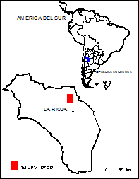
Figura 1: Location of study area
This area includes the north-south trending tectonic depression bounded by the mountain range of Velasco, to the west and the south, and by the mountain range of La Punta, to the east.
The mountain range of Velasco reach the altitude of 4.000 masl, whereas its neighboring valleys are at about 2.000 m.
The area is characterized by a continental, subtropical Atlantic pluviometric regime, with maximum rains in the months of summer, and scarce precipitations in winter. For the 1958-1970 period, some annual average precipitations for the proximal, pedemontal area were: 124 mm in Pinchas; 130 mm in Chuquis; 150 mm in Aminga; 157 mm in Anillaco; 177 mm in Anjullón and 200 mm in Santa Cruz (Del Moral, 2002).
In order to accomplish this work, different activities in campaign and cabinet were made, that included the bibliographic compilation and analysis of previous work, geomorphologic and geologic field inspection, mapping of existing underground and superficial water sources, static water levels and well water flow measurements, geophysical prospection (geoelectric) and sampling of different water sources with physical - chemical analysis – both at camp site and laboratory-.
Results
Geologic of Surface. The local stratigraphy includes Precambrian to Lower Paleozoic units as well as Tertiary and Quaternary terrains (Figure 2).
Precambrian – Lower Paleozoic (Unit 1). Mainly composed of granites, migmatites and gneisses, this “crystalline basement” form the mountain ranges bounding to the west, east and south, the Amingas – Pinchas valley. These terrains display secondary porosity due to their fractures (faults and diaclasas) and to the weathering processes originating springs wich feed drainage network. Par of them are captated through impoundings such those existing in Pinchas, Chuquis, Aminga, Anillaco, etc.
Tertiary (Unit 2). It is characterized by the sediments of the Salicas (Schaquis) Formation , which mainly cropps out in the northern par of the area. Its lithology is composed of sandstones, conglomerates, and limolites and shales with variable degree of compaction, cementation and fracturation. In addition they contain gypsum as plates and veinlets. This unit presents permeable levels that allow to the circulation of the water through their pores and specially by the planes of stratification and fractures. They are considered aquifers but less significant than those of the Quaternary.
Quaternary (Unit 3). The Quaternary mainly includes fluvial and alluvial sediments coming from the mountainous ranges bounding the Aminga-Pinchas valley, such as the cones and alluvial fans that conform the slope and alluvial peneplain. The valley has been filled up by several sedimentary cycles. The granulometry of theses deposits is mainly of coarse type, gravel and sand , with subordinate finer material. The porous and permeable horizons of this unit provides the best aquifers of the area
Structure. The present tectonic and structural configuration of the area reflects the latest Cenozoic Andean movements. Both the mountain range of Velasco and the mountain range of La Punta belong to the Sierras Pampeanas mountain range system, and are high-angle uplifted basement blocks of Precambrian to Lower Paleozoic age, having a general north-south trend. Conjugated NW and NE megafractures are conspicuous features affecting these ranges. These basement blocks are separated by the Amingas-Pinchas intermountain depression, filled up by fluvial and, to a lesser extent, aeolian sediments. The neotectonic activity is registered in the pedemontal area between Aminga an Chuquis.
Census of the groundwater impoundig. The fieldwork activities included the hidrogeological census of the groundwater impounding existing in the Aminga – Pinchas valley, whose location is indicated in Figure 2. A total of 17 impounding was recognized, 16 of which are perforations and the rest corresponds to an dug well where the water is extracted by means of bucket. The collected information included the georeferencing of wells by means of the Global Positioning System (GPS), field data gathering such of hidrological and hidrochemical measurements, such as groundwater levels, water flow regime, electrical conductivity, and obtaining oral information on the use of the water. Geologic profiles were compiled from several wells that included granulometric and lithologic descriptions, details of casing and filters; groundwater levels, water flows, etc (APA, 2004), (Winery San Huberto, 2004). Only 4 perforations were in operation and the water is used for irrigation of grapevine mainly. The rest were without equipping or with problems in the pumping equipment.
The minimum and maximum depths of perforation are of 147,30 m and 354 m respectively. The depth of groundwater levels varies between 75,74 m and 304,00 m; the well water flow are variable between 3 m3/h and 131 m3/h; the yields varies between 0,09 m3/h/m and 8 m3/h/m and the water electrical conductivity is between 485 µS/cm and 1012 µS/cm. In the southernmost part of the valley two wells were identified whose water levels
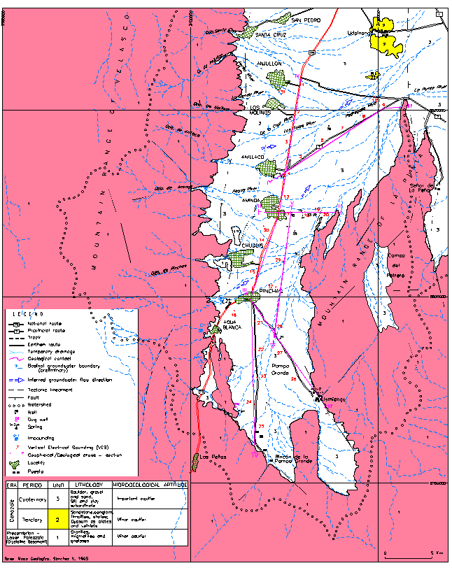
Figure 2: Hidrogeological Map
were respectively located between 6,75 and 32,32 m of depth.
Geoelectrical prospection and subsoil geology. The geoelectrical prospection was made with the aid of digital Prakla- Seismos resistivity-meter, of 800 Volts of maximal tension, 2 Amp of tip current and 1 Meghom of entrance impedance. The values of resistivity are calculated in automatic form by the built-in microprocessor what annuls the possibility of computational errors. The underground electrical field is measured by means of steel electrodes (4 or more in each point of measurement), connected in parallel. The potential difference readings is made by means of bronze electrodes, nailed to variable distances. The cables of emission and reception of current are multi-wire of copper and steel with case of PVC, which provides good conductive properties and elevated tensile strength. The used electrodic configuration was the symmetrical tetrapoles Schlumberger type. The depth of investigation of the subsoil is determined by the extension of the emission wings; in this sense, the cables were extended until detecting the totality of the sedimentary column that overlies the basement. Occasionally, some limitation was imposed by terrain difficulties or to obtain good tension readings. AB wings apertures oscillating between 2.000 m and 4.000 m were normally reached. In cabinet, the vertical electrical sounding (VES) data was processed and plotted by means of the Resix Plus V 5,0 software. This was done in order to quantify the different electrical layers from the subsoil through the determination of their thickness (in meters) and their resistivity (in ohm.m) and the elaboration of geophysical, geological and/or hydro-geological cross-sections. This consists of finding the pattern who ties the numeric data obtained by calculation, with hidrogeological or geological aspects. The obtained solution becomes more accurate as the interpreter skills increases, and with more and reliable geological support.
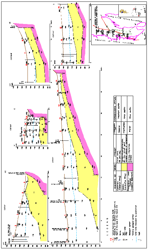
30 VES with an average spacing of 3 km were registered, from which 5 geophysical/geological cross-sections cuts were made: three along the “West-East” direction, whereas the other two have a North-South orientation (Figures 2 and 3).
As a result, three hydrogeological units were identified: The Inferior Hydrogeological Unit; the Intermediate Hydrogeological Unit and Superior Hydrogeological Unit (Figure 3).
The Inferior Hydrogeological Unit is a resistive electrical layer which geologically corresponds to the resistive crystalline basement, whose values vary between 100 ohm.m and more than 1.000 ohm.m. Its outcrops constitute the mountain ranges of Velazco and La Punta, margins that define the Aminga – Pinchas valley. This unit is interpreted as being an poor type aquifer and is detected at variable depths between about 120 m and more than 600 m. None of the existing wells penetrated into the basement.
The Intermediate Hydrogeological Unit electrically responds with values between 4 ohm.m and 20 ohm.m and constitutes the conductive filling. It is correlated geologically with the Tertiary sediments (sandstones, conglomerates, clays, silts, etc, with variable degree of compaction and cementation) accumulated above the basement paleo-surface. It constitutes the hydrogeological basement to the groundwater Quaternary basin and it can be found a variable depth between 40 and more than 600 m.
This pre-Quaternary basement plunges from the mountain range of La Punta (E), and from the mountain range of Velasco (S), towards the zone of Anillaco-Anjullón.
The well N° 1 (Pampa Grande), located in the South end of the cut IV-IV', would be the unique one that extracts water from Tertiary aquifers: from the 89 ms of depth on, it crosses, reddish brown argillaceous conglomerates and sandstones, as well as white pinkish and strongly consolidated sandstones. They have two intercalated layers of permeable gravel in which the water filters were located. Judging by the obtained values of the tests of pumping in the well at issue (yield 0,086 m3/h/m), this intermediate unit is comparatively of smaller importance than Superior Unit (described in the following paragraph).
The Superior Hydrogeological Unit includes electrical layers with values of resistivity that vary between 32 ohm.m and more than 2.000 ohm.m, constituting the Quaternary resistive filling. The subsoil cross-sections show that a thick filling of this Quaternary unit, composed of boulders, gravel and sandstones intercalated with clays, overly the intermediate hydrogeological unit. The thickness increases along the South-North and East-West directions, and eventually depasses the 500 m (north ends of cut IV-IV' and southwest end of cut I-I'; zone of Anillaco – Anjullón). The minimum thicknesses are of about 40 m to 70 m (towards the northeast end of cut I-I' and the south of cut IV-IV' respectively).
This thick sediment accumulation hosts the underground Quaternary basin containing the most significant free aquifers (with primary porosity) of the area, which are currently used for irrigation purposes. This preliminary basinal boundary was defined

through the geophysical – geological prospection, remote sensing analisis and the available geological data (Figure 2). The saturated thicknesses are variable and might surpass the 350 m.
The water-saturated underground Quaternary basin ends to the south of the studied area in Pinchas zone, as well against the slope hills of the mountain range of La Punta, to the East (Figures 2 and 3).
In general, the water-saturated layers are deep, located between 137 m and 304 m (Anillaco area)
The existing perforations in the zone of Anillaco, extract volumes of the order of the 21 m3/h to 25 m3/h, whereas the specific yield is only known in one well and is of 1,34 m3/h/m.
The wells located in the central part of the basin, to the east of Aminga and Chuquis, extract greater volumes, arriving at the 131 m3/h and their specific yields also more are elevated; between 5,5 m3/h/m and 8,11 m3/h/m.
This groundwater reservoir is recharged from rains in the mountain ranges (Sierra de Velazco) and the natural discharge takes place through the Tertiary permeable layers, and through springs located along the slopes (“bordos”), process which allows the water passage from the De la Costa basin to the Oriental sub-basin (Sanchez et al., 1995), being the latter developed to the east of the fault that bounds the mountain range of La Punta and the Udampinango slopes along their eastern flanks (Figure 2).
Hidrochemistry. 14 water samples of a total of 21 visited sources were obtained; 8 of these samples correspond to superficial resource and 6 to the underground resource.
Of the underground ones, 4 belong to equipped perforations currently in operation and the two others correspond one to perforation with casing but without equipping and the other to an dug well. Of the 8 superficial water samples, 5 correspond to impoundings of the eastern drainage of the mountain range of Velasco, and 3 to springs (Figure 2)
At the moment of the sample collection, determinations of temperature, pH and electrical conductivity were made. The total of the collected samples was correctly preserved and sent for analysis to the Chemical Laboratory of the CRAS, where the following determinations were made: electrical conductivity, pH, total alkalinity, total hardness and hardness of non-carbonates, dissolved solids calculated, calcium, magnesium, sodium, potassium, carbonate, bicarbonate, sulfate, chloride, fluoride, boron, nitrate, nitracurite, arsenic, phosphorus and silica contents.
Table 1 shows the result of the chemical analysis of water samples from different sources (wells, impoundings and springs) as well as the hystorical chemical analysis of previous holes and the water aptitude for different purposes (cattle, irrigation, partial potability)
The adopted criterion to classify waters for irrigation is the one of five classes of Flannery – Lohn (Lohn, 1969); it takes into account the total salinity based on the specific electrical conductivity of the water that establishes the salinity toxicity, the sodium content with respect to other ions such as calcium and magnesium, through the concept of Sodium Adsorption Ratio, -or SAR- that indicates the sodium toxicity, the residual sodium carbonate –or RSC- that evaluates the possibility of carbonates and bicarbonates to precipitate and finally, the boron toxicity according to the different tolerance of the plants to this element (Figure 4).
The norm adopted for the cattle consumption is the one of the Farming Direction of the province of Mendoza, Argentina, that considers solely the dissolved solid tenors, magnesium and sulfate contents, depending on whether the water is going to be used for bovine or ovine cattle. For potability the adopted norm is that of the Argentinian Nourishing Code – or CAA- (2004).
The Durov Modified diagram (Lohn et al., 1969) was used for the interpretation of the hidrochemical characteristics of waters which allows, based on the percentage composition of elements that surpass concentrations over the 15% meq/l, the grouping and classification of the different sources according to their chemical characteristics. Figure 5 shows the total amount of sources considered in the interpretation. They have been separated into similar groups: Group I (impoundings C-1, C-2, C-3, C-4 & C-5), Group II (springs V1 & V3), Group III (wells P-18 & P-19), Group IV (wells P-16 & P-17) and the group of unrelated springs (i.e.V-2), and wells (P-25, P-1, P-2, P-27 and P-28).
Chemical characteristics of the superficial water (impoundings and springs). The superficial water drained from the Sierra de Velazco is capted through a serie of impoundings, and is mainly used for human consumption and for agricultural purposes. The water of these impoundings, which are located in the localities of Agua Blanca (C-1), Pinchas (C-2), Chuquis (C-3), Aminga (C-4) and Anillaco (C-5), was systematically sampled; the average flows are of the order of the 30 ls/seg to 90 ls/seg (Sanchez et al. 1995).
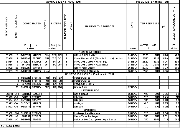
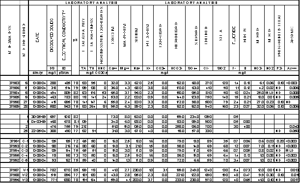
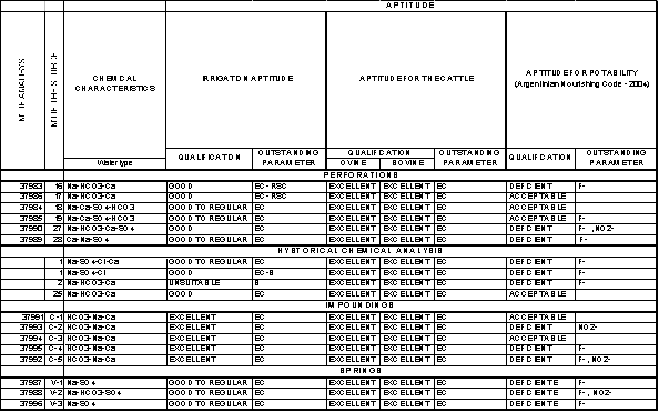
Table 1: Chemical analysis of water samples
(wells, impoundings and springs) and hystorical chemical analysis
Figura 4: Watering Clasification System Figura 5: Chemical characteristics (groundwater and
superficial water)

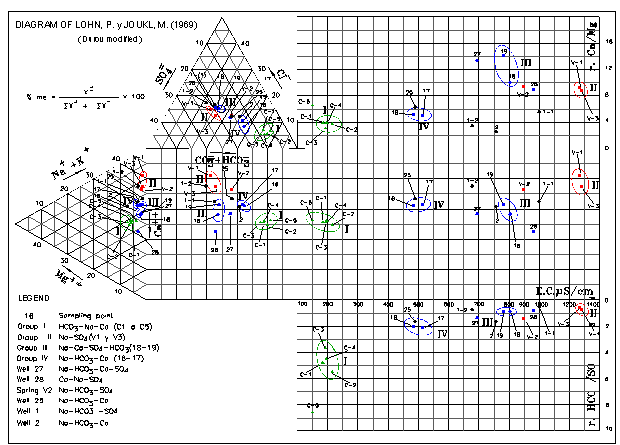
The diagram of Durov (modified) show that they constitute a group of water of similar charachteristics, or Group I (bicarbonated–sodic-calcic) with a saline content, expressed as electrical conductivity, ranging from a minimum of 162 µS/cm (dissolved solids: 93 mg/l) to a maximum of 216 µS/cm (dissolved solids: 130 mg/l), being their average in the order of 191µS/cm (dissolved solids 110 mg/l) (Figure 5)
The maximum tenor of fluoride corresponds to the Anillaco impounding (C-5) with 3.4 mg/l. The values of boron are the lowest in the area, with a maximum of 0,10 mg/l.
The contents of nitrate and phosphorus are of 7,0 mg/l and 0.2 mg/l respectively (maximum value), whereas the arsenic is present in a quantity of less than 0.003 mg/l (detection limit).
The nitrite tenor displays values between 0.03 mg/l and 0,21 mg/l. The aptitude for irrigation of all sampled water is excellent (Class I). These water are also good for the cattle, with the only exception of the Anillaco impounding (C-5) that surpasses the tolerable limit of fluoride (2.0 mg/l) (Water Quality Criteria, 1972).
The water of the Pinchas (C-2), Aminga (C-4) and Anillaco (C-5) impoundings are not potable, due to higher than limit levels of fluoride (more than1,2 mg/l and 0.10 mg/l respectively).
The three analyzed springs, whose flows were between 0,05 l/seg and 2 ls/seg, are used only for the cattle, with the exception of Ismiango (V-1), which is suited for human consumption.
V-1 and V-3 are described as sodic-sulphated and V-2 as sodic-bicarbonated-sulphated. Their electrical conductivity varies between 896 µS/cm (dissolved solid: 519 mg/l) and 1280 µS/cm (dissolved solid: 771mg/l).
The tenor varies between 4,0 mg/ls and 5,4 mg/l for fluoride; between 0,47 mg/l and 0,73 mg/l for boron; and between 0,011 mg/l and 0,017 mg/l for arsenic. The nitrate and nitrite contents vary between 9.9 mg/l and 41 mg/l, and between 0.01 mg/l and 0.3 mg/l respectively.
For irrigation purposes, the water of these area is good to regular (class III). It is classified as excellent for the cattle. It is not considered as suitable for human consumption, due to its higher tan acceptable levels of fluoride and nitrites. Moreover and according to the World Health Organization (1995), the values of arsenic, boron and sodium generally exceed the values guides of potable water (0,01 mg/l, 0,3 mg/l and 200 mg/l respectively).
Chemical characteristics of the underground water. The most important Quaternary underground water basin of the area was sampled and analyzed, in general, in its central part (Figure 2), where the type of water varies between sodic-bicarbonated-calcic and sodic-calcic-sulphated-bicarbonated.
The electrical conductivity, with an average of 639 µS/cm (dissolved solids 391mg/l), oscillates between 485 µS/cm (dissolved solids: 288 mg/ls) and 809 µS/cm (dissolved solids: 494 mg/l); The pH varies between a minimum of 7.7 and a maximum of 8,2.
The fluoride, with an average of 1.2 mg/l, has a minimum concentration of 1 mg/l and a maximum of1.5 mg/l; the boron tenor varies between 0.12 mg/ls and 0.24 mg/l; the maximum arsenic content is of 0.008 mg/l, whereas those belonging to the nitrate and the nitrite are of 25 mg/l and 0,06 mg/l respectively.
The southernmost well P-2 of Pampa de Chuquis constitutes an exception of high fluoride (3 mg/l) and boron (4 mg/l) tenors.
The water aptitude for irrigation varies between good (class II) and good to regular (class III). In the first case the dissolved solid content and the residual sodium carbonate are the quality defining parameters. The water is good for most crops, with the only exception of those very sensitive to salinity.
In the second case the dissolved solid content defines such qualification and this type of waters is applicable to crops with moderate to good tolerance to the salinity. Only in the single in a case (well P-2) the water is unsuitable (class V) for irrigation due to higher boron levels.
For human consumption, the water potability is restricted, since the fluoride levels are often surpassed and, as is the case in wells P-2 and P-25, the levels of arsenic and boron are higher than recommended by the WHO. For the cattle, the water quality is excellent.
The well P-1 in Pampa Grande is located outside the boundaries of the Quaternary basin, in the southern part of the Amingas-Pinchas valley, and exploits two aquifer levels of Tertiary age.The first level, located between the 98 ms and 104 ms of depth, presents a conductivity of 1012 µS/cm (697 mg/l of dissolved solid l) and the water is classified as sodic-sulfate-clorurated-calcic. The only minor element analyzed is the fluoride, present in a low concentration of 0,5 mg/l.
The second aquifer level is deeper and located at 123 to 130 meter from the surface. It has a lower salinity, of 678 µS/cm (468 mg/l of dissolved solid l) and is defined as sodic-sulphated-clorurated. The fluoride and the boron with tenors are of the order of 0,5 mg/l and 0,80 mg/l respectively.
In both aquifer levels, the fluoride tenor is below the potability limit of 0.7 mg/l and, according to the WHO, the boron content (0.8 mg/l) is above the recommended values. For the cattle the water is excellent, whereas for irrigation the first level is good to regular (class II), and the second one is good (class II)
Conclusions
The underground water basin geometry of the Amingas –Pinchas valley was preliminary defined through the geological and geophysical work carried out in this study. Three hydrogeological units – Inferior, Intermediate and Superior- were subsequently differentiated within the basin.
The Inferior Hydrogeological Unit is electrically resistive (100 ohm.m to more than 1.000 ohm.m), is correlated with the crystalline basement and it is detected to variable depths between about 120 m and more than 600 m (with the only exception of the Anillaco-Anjullon area, where it was not detected). It constitutes a fissure aquifer and it has not been reached by the drillings.
The Intermediate Hydrogeological Unit, electrically conductive (4 ohm.m to 20 ohm.m), is correlated with the Tertiary formations and constitutes an aquifer that is currently exploited by a perforation located in the southern part of the valley. It has remarkably inferior flows and yields to those of the Superior Hidrogeological Unit. The water quality varies from regular – good to good, being suitable for irrigation purposes. It is excellent for the consumption of the cattle, but its fluorine deficiency makes it unappropiate to human consumption. This unit represents the hydrogeological basement for the Quaternary groundwater basin, and it is located at variable depths between 40 m and more than 600 m.
The Superior Hydrogeological Unit, electrically resistive (32 ohm.m to more than 2.000 ohm.m), is correlated with the Quaternary deposits and constitutes an important sedimentary basin whose greater thicknesses are located in the zone of Anillaco – Anjullón, where they can surpass the 600 m. The minimum thicknesses are of the order of the 40 m to 70 m towards the northern end of the Sierra de la Punta range, and in the southern part of the Aminga – Pinchas valley. This sedimentary deposit contains the most important Quaternary free aquifers of the area, which are being used for irrigation through wells whose water levels varies between 137 m and 304 m. Their flows and yields are up to 131 m3/h and 8,11 m3/h/m respectively in the central part of the basin. The maximum saturated thicknesses of the basin are of the order of the 450 m in the zone of Anillaco - Anjullón.
In the central part of the Quaternary groundwater basin (zones of Anillaco and eastern Aminga), the type of water from the aquifers varies between sodic–bicarbonated-calcic and sodic–calcic-sulphated-bicarbonated. The water quality for irrigation alternates between good and good to regular. In the southern part of the basin (to the east of Chuquis) the underground water can be unsuitable for irrigation, having high level of boron. For consumption of the cattle the water is excellent, whereas in some cases the fluoride and the boron contents surpass the recommended maximum limits for drinking water.
The quality of the superficial water impoundigs is excellent for irrigation whereas the water from springs are of good to regular type. Both sources have elevated fluoride tenor (occasionally nitrites), limiting their quality for human consumption, whereas is excellent for the cattle.
References
[1] San Huberto Wineries, 2004. “Well data from Anillaco and Aminga, in the S. Huberto’s properties”.
[2] Argentinian Food Code. 2004. Chapter XII. Water and gasified water, Artícle 982, Potable Water. Last Update April/2004.
[3] Del Moral D. 2002. The remote sensing as effecting tool in the exploration of aquifer feeding areas, Castro Barros Departmen. La Rioja Province. ( APA).
[4] Administration for Cattle Issues, Mendoza Province, Argentina. Index for water consumption of cattle
[5]
Water
Quality Criteria, Environmental Studies Board,
[6] Lohn P. 1969. Water Classification and Quality Criteria for Irrigation. Underground Water Plan, Technical Report - 004.
[7] Lohn P, Joukl M, 1969. Underground water geochemistry, Valle Fértil basin, San Juan Province. Underground Water PlanTechnical Report P-003.
[8] World Health Organization (OMS). 1995. Potable Water Guide
[9] Sánchez V, Gianni R, Di Chiacchio J, Victoria J, Pellegrino J, Mercado N, Guimaraes R. 1995. Hidrogeological evaluation of the Colonia Machigasta – Bañado de Los Pantanos area. La Rioja Province. (CRAS). Technical Report IT- 166.
[10] Torres C, Gianni R, Ferrés C. 2004. Hidrogeology and Hidrochenistry of Amina-Pinchas area, Preliminar study, Castro Barros county. La Rioja. National Water Institution (INA) – (CRAS). Technical Rep. IT-227.
[11]
Water Administration of La


