Evolutional Rules of Regional Groundwater System
REGIONAL FLOW SYSTEM DELINEATION IN ARID KARSTIC BASINS WITH SPARSE HYDROGEOLOGIC DATA: CUATRO CIENE GAS BASIN, COAHUILA,MEXICO
Brad D. Wolaver • John M. Sharp, Jr. • Juan Manuel Rodriguez
Abstract: This research develops a procedure for the delineation of regional groundwater flow systems in arid karstic basins with sparse hydrogeologic data using surface topography data, geologic mapping, permeability data, chloride concentration of groundwater and precipitation, and measured spring discharge data. Aquifers are characterized using geographic information systems (GIS) for groundwater catchment delineation, an analytical model for interbasin flow evaluation, a chloride‑balance approach for recharge estimation, and a water budget for mapping contributing catchments over a 45,000km2‑region. The study area includes the Cuatro Cienegas Basin of Coahuila, Mexico, a National Biosphere Reserve containing dozens of springs supporting groundwater dependent ecosystems and irrigated agriculture. Sustainable groundwater development is a key issue on the U.S.‑Mexico border; however, these procedures may be used in arid karstic basins globally.
Keywords: Groundwater recharge/water budget, groundwater flow, water supply, arid
regions, karst, carbonate rocks, Cuatro Cienegas,
Introduction
The objective of this study is to map regional
groundwater flow systems in the arid
Methods
A regional flow system is delineated using surface topography, geologic maps, an analytical model for interbasin flow determination, and chloride‑balance recharge estimation using a water budget approach:
R = P Cp / Cr (1)
where R=groundwater recharge, P=precipitation, Cp=bulk precipitation chloride concentration, and Cr=groundwater chloride concentration. Groundwater catchments are mapped in GIS using the eight direction pour point model with a 90m2 digital elevation model (DEM). Carbonate rocks forming uplands are delineated from geologic maps. Groundwater flow between basins under topographic divides is evaluated using the analytical model:
![]() (2)
(2)
where h(x)=hydraulic head at any point(x) in an unconfined aquifer with heads(h1andh2) on either side of a topographic divide of hydraulic conductivity(K), length(L), and constant recharge(Ws). A steady‑state water budget is assumed for predevelopment conditions, where inputs are chloride-balance estimated recharge (accounting for evapotranspiration); outputs are spring discharge measured by this project (assuming negligible regional open water evaporation). Regional flow is mapped using a water budget approach; groundwater recharge for successively higher elevation groundwater catchments is summed until observed basin discharge is equal to estimated recharge.
Results and Discussion
Results suggest: 1) groundwater discharges at Cuatro Cienegas
Basin because it is the lowest
regional elevation; 2) interbasin groundwater flow occurs because topographic
divides comprised of highly‑permeable carbonates do not represent groundwater
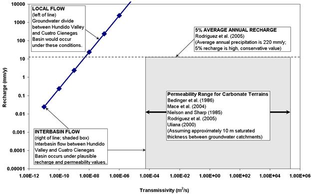
divides (Figure 1) and; 3) up to six hydrogeologically linked groundwater
catchments in a 160‑km long flow system discharge in the
Figure 1. Analytical model results suggest interbasin flow occurs.

References
[1]
Bedinger MS, Langer WH, Reed JE (1986)
Synthesis of hydraulic properties of rocks with reference to the Basin and
Range Province, southwestern United States.
[2] Johannesson KH, Cortés A, Kilroy KC (2004) Reconnaissance isotopic and hydrochemical study of Cuatro Ciénegas groundwater, Coahuila, México. Journal of South American Earth Sciences 17:171‑180.
[3] Lesser y Asociados (2001) Sinopsis del estudio de evaluación hidrogeologógica e isotópica en el Valle del Hundido, Coahuila. Comisión Nacional del Agua, Subdirección General Técnica, Gerencia de Aguas Subterráneas.
[4]
Mace RE, Angle ES; Mullican WF (2004) Aquifers
of the
[5]
Nielson PD, Sharp JM Jr (1985) Tectonic
controls on the hydrogeology of the Salt
Basin, Trans‑Pecos,
[6] Rodriguez AAA and others (2005) Estudio hidrogeológico de los acuíferos el Hundido y Cuatrociénegas, Coahuila. Secretaria de Medio Ambiente y Recursos Naturales, Instituto Mexicano de Tecnología del Agua, Comisión Nacional del Agua, Instituto Nacional de Ecologia:292.
[7]
Uliana MM (2000) Delineation of regional
groundwater flow paths and their relation to structural features in the Salt
and Toyah Basins,
Trans‑Pecos,
[8] Wolaver BD, Banner JL, Sharp JM Jr (2005) Groundwater recharge in the Cuatro Cienegas Basin, Mexico: Insights from strontium isotope and trace element analyses. Poster presented at the Annual Meeting of the Geological Society of America 37:361.


