


Achievements
A STUDY ON THE RATIONAL EXPLOITATION AND UTILIZATION OF THE SALT WELL WATER RESOURCES IN COASTAL AREAS OF XINGCHENG CITY
Ding Yuanfang, Chi Baomin, Lan Shuangshuang
College of Environment & Resources,
Abstract: The Salt well water is a special type of groundwater resources, which usually distributes in coastal areas. The Salt well water, called saline groundwater, is caused by the seawater intrusion in coastal areas. In the coastal areas it exists salt-fresh water transition belt with a certain thickness, and freshwater gradually becomes salty in the vertical direction in the belt. Therefore, it is possible to exploit the available Salt well water sustainably in the appropriatly restricted conditions of pumping well’s depth and mining.
There are abundant Salt well water resources in coastal areas of Xingcheng city in
However, as a result of excessive and sustainable exploitation of the Salt well water, serial environmental problems have been brought about in fishery garden, such as seawater intrusion, groundwater drawdown continuously,degradation of groundwater quality and so on. Thus, in this paper the technique of groundwater numerical simulation has been used to assess quality and quantity of the Salt well water, and forecast varying tendency of water level and salinity in the situation of exploitation. In the end, some
suggestions and tactics have been provided for rational exploitation and utilization of the Salt well water.
This paper can provide the decision makers with important informations on the actual amount of the Salt well water and present status of their spatial distributions. This will be helpful for reasonable planning and management of the Salt well water resources.
Key words: Salt well water, Exploitation and utilization, Coastal areas, Aitificial cultivation, Environmental problem
Introduction
The Salt well water is a special type of groundwater resources, which is abundant in the coastal area of Xingcheng city,
1 General Situation of the Salt Well Water Resources
1.1 Cause of Formation
Before massive exploitation to the groundwater in coastal areas, seawater intrusion has already existed and changed with time. On the natural conditions, the sea water intrudes land under the fresh water body, the salt and fresh water in the aquifer maintains some dynamical balance, and forms either thick or thin transitional belt. In coastal areas, owing to the existence of the transitional belt with some thickness, the fresh water gradually changing to salt water in this belt. So it is impossible to sustainablly exploit available saltish groundwater, so-called the Salt well water, by the limitation to depth and exploitation of pumped well.
1.2 Distribution
In coastal areas of the Northern China, the Salt well water mainly distributes in these places such as the shore plain of Bohai Bay and
1.3 Characteristic
In coastal areas of Xingcheng, the Salt well water characteristic includes: ① Fine water quality: the water is limpid by filtering when passing through the deep stratum; PH-value is among 7.4 - 8.0; K+, Na+, Ca2+, Mg2+, NO3-, SO42- and heavy metal ion in the water fits the quality standard for fishery breeding. ② Stable salinity: Salinity is between 20-25‰. ③ Higher and unvariable water temperature: the Salt well water temperature keeps among 13~
However, the above characteristic has changed owing to the influence of human activities.
1.4 Exploitation and Utilization
Early 90s in
Xingcheng is located in the west bank of
2 General Situation of the Research Area
It was the Caozhuang town that the Salt well water storage is the most abundant in the coastal area of Xingcheng, therefore, taking the Xingcheng modern fishery garden in the town as the example, this paper discusses the problem that how to exploit and utilize rationally the Salt well water resources in coastal areas of Xingcheng city. Owing to massive exploitation of the Salt well water in the fishery garden, the environmental geology problems are also extremely remarkable. Figure 1 shows the scope of the research area.
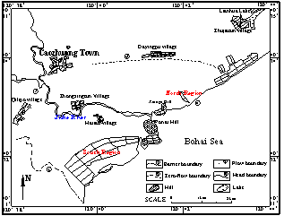
Fig. 1 The scope of the research area
2.1 Topography and physiognomy
Xingcheng modern fishery garden is located alluvial plain in the southeast of the Caozhuang town, which is divided into two areas by
2.2 Meteorology and hydrology
The research area belongs to warm temperate semi-humid monsoon climate, annual average air temperature is
2.3 Groundwater System Characteristic
According to the origin and structure characteristic of aquifer, loose rocky porous water-bearing formation is divided into three formations, the first is the fresh water-bearing formation which is composed of alluvial sand and gravel (or interweave soil), the second is the fresh water-bearing formation which is composed of slope sand and gravel, the last is the salt water-bearing formation which is composed of alluvial sand and gravel (or interweave soil). Then, the latter distributes widely in coastal areas. The above of the aquifer covers the alluvial layer whose main component is the dust sub-sandy soil and its thickness is less than
In nature, supply sources of the research area contain atmospheric precipitation and groundwater runoff from upstream, groundwater runoff from piedmont at northwest to coast at southeast. Groundwater discharge contains flow towards the sea and phreatic evaporation. In coastal areas, the seawater and the fresh water don’t have the obvious aquiclude and hydraulic relation. Salty water intrudes towards the fresh water body of the interior in the form of wedge through the beach of the sea, thus salt-fresh interface is formed which inclines towards the interior. The conformation and outspread length of the interface are mainly effected by the ground fresh runoff from the land to the sea which is controlled by exploitation and recharge in the upstream. In recent years, large ground fresh water was exploited for paddyfield irrigation, which leaded to the reducing quantity of the ground fresh water flowing into the sea. The large-scale running of the garden and massive exploitation of the Salt well water have brought about interface moving inwards and seawater intruding.
The chemical characteristic of the groundwater is controlled by the physiognomy, water-bearing medium, the sea water level change and human activities. The coastal areas such as marine-deposition plain have flat terrain, slow runoff, shallow buried depth of the water level and strong evaporation condensation, all conditions of which make kinds of chemical component enrich timely, and meanwhile suffered the influence of the seawater intrusion, so the hydrochemistry type has changed from sodium-calcium surphate-chloride water to sodium chloride water. The total ionic concentration increases markedly, reaching to 5~
2.4 Present situation of groundwater development and utilization
In the research area, the groundwater resource has been more fully developed and utilized, main purposes contain fishery breed, agricultural irrigation and domestic use. According to statistical data, the area of the paddyfield is
Table 1 The statistic of kinds of groundwater withdrawal in 2004
Item | Garden withdrawal | Domestic withdrawal | Agricultural withdrawal | Total |
quantity (million m3) | 20.52 | 0.42 | 2.25 | 23.19 |
Proportion (%) | 88.5 | 1.8 | 9.7 | 100 |
3 Evaluation of the Salt Well Water Resources
3.1 Numerical simulation
According to the above hydrogeological conditions, loose rocky porous water-bearing formation which has the uniform hydraulic relation is treated as the computation region and is generalized as the heterogeneous isotropic two-dimensional non-stable phreatic aquifer.
The upper boundary is the free water surface of the phreatic aquifer. The bottom boundary is the top layer of andesite volcanic breccia of the cretaceous Yixian group, which is generalized as the barrier boundary. The southwest boundary is the contact zone of the rolling terrain and the Quaternary, which is generalized as the water-tight boundary. The northwest boundary is the positional boundary from Qilipo village to Canzhuang village, which is generalized as the flow boundary. The north boundary is the underground watershed from Caozhuang village to Dayingpu village, which is generalized as the zero-flow boundary. The southeast boundary is the littoral boundary, which is generalized as the specified head and concentration boundary.
According to the hydrogeological conceptual model, the corresponding mathematical model is established. The Visual MODFLOW soft of the groundwater flow numerical simulation would be used to compute the mathematical model, which based on the finite difference principle. Furthermore, MT3D module of the software will apply to concentration migration simulation of the chloride. Divide the aquifer into eight hydrogeological parameter sectors. The primary aquifer parameters include hydraulic conductivity, specific yield, precipitation infiltration coefficient, degree of dispersion, and so on. It chooses the dynamic observation data of the groundwater level and the detection data of the chloride from January to October in 2005 as the data of the model calibration and verification. The fitting result which obtains by the method of trial-and-error must carry on two aspects evaluation. The calculational value of the water level and chloride ion concentration must be consistent with the actual value; the variational trend of the calculational flow field and constant concentration line must be consistent with the actual trend. If these conditions could be fit to the fact, which include aquifer structure, the generalization boundary condition, the selection of hydrogeological parameters and the items of recharge and discharge, then the mathematical model can be used to evaluate the Salt well water resources.
3.2 Evaluation of the salt well water resources
According to the above model, annual exploitation yield of groundwater can be computed in the actual exploitation condition of the research area. Then the distribution and movement of the chloride was obtained by the coupled model of the water quantity and the water quality. Convert the concentration of chloride into the salinity, thus, the different salinity per centum would be calculated by the control areas of different salinity. The Salt well water resources allowable exploitation yield of kinds of salinity can be ensured by the product of the different salinity per centum and annual exploitation yield of groundwater. When evaluating the Salt well water resources, the quantity are calculated respectively for South region and North region of the garden.
According to the analysis for the precipitation information of the Xingcheng city from 1956 to 2000, predicted precipitation from 2006 to 2010 is obtained by the Monte-Carlo model; the precipitation of frequency year is also obtained by the fitting method of the Pearson- III curve, then table 2 shows the calculated results.
Table 2 Calculation value of the precipitation
Year | Predicted Precipitation(mm) | Precipitation frequency year | Precipitation (mm) |
2006 | 425.4 | 25% | 786.6 |
2007 | 702.2 | 50% | 523.9 |
2008 | 483.9 | 75% | 323.6 |
2009 | 702.2 | 95% | 143.5 |
2010 | 538.8 |
|
|
Researching the dynamic change characteristic of the groundwater and considering the limitation of existing data, the flow field of October 1, 2005, is dimmed as initial flow field of the groundwater prediction. The lateral flow of boundary calculates by the Darcy’s law. The irrigation infiltration yield calculates by the method of irrigation ration which can be inquired according to precipitation. The present water consumption is regarded as the groundwater exploitation in the period of prediction.
According to the typical year precipitation, numerical simulation runs in the condition of the present exploitation. The simulation result shows that, the groundwater regime in the research area is mainly related to the exploitation and seawater recharge; the flow field change is small. The cone of depression form in the near of fishery garden and Dayingpu village, which has more extendable and connective trend in the drought year than in the rainy year. In the last period of the typical year, the concentration trends in the research change greatly, the variation range of the chloride concentration is among 800~16000 mg L-1, then converts into the salinity is 2.1 ~32.9 ‰.
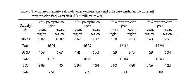
Considering the salinity demand of the fishery garden for breed use, the exploitation yield of different salinity demand is calculated, the result is showed in table 3.
According to the forecasted sequence of precipitation, numerical simulation runs in the condition of the present exploitation to the year 2010. The simulation result shows that, groundwater flow field occurs corresponding change along with the alternation of the rainy period and the drought period. The cone of depression assumes the expanded trend; it suggests that the research area is at the negative balance situation. The chloride concentration assumes the ascending trend. Furthermore, the salty water diffuses gradually towards Dayingpu village from two sides; the scope of seawater intrusion enlarges.
In order to analyze the development potential of the Salt well water resources, the fishery garden exploitation quantity is expanded to 30 million m
The simulation result shows that, the whole fishery garden assumes the negative equilibrium situation after expanded exploitation, the cone of depression center in North region moves to the Dayingpu village, the groundwater level drops gradually. The cone of depression table drops from
The availabe exploitation of fishery garden is more in rainy year than in drought year. If the present exploitation continues for five years, the research area will be the negative balance situation, leading to the area of seawater intrusion increases. According to the present layout of exploitation, it has lesser feasibility to enlarge the exploitation because of the bad environment problems. However, if some measures are taken, such as optimizing the layout to avoid centralized exploit, or turn the well irrigation to ditch irrigation to reduce the exploitation of groundwater, it will increase the recharge of fresh water to groundwater, so the available exploitation will be enlarged.
4 Inducing Environment Problems
4.1 Seawater intrusion
The cause of sea water intrusion is mainly due to human activities because of large exploitation of the Salt well water in coastal areas, and that does not imply the natural factors (the water level difference and air pressure difference caused by precipitation, tide and wind) will be excluded. The fishery garden locates on the mixing area of seawater and fresh water. The lay of pumped well of the Salt well water, just like a row of pumped well on coastal line, will make the intrusion area form a descent tank to prevent the intrusion of seawater to fresh water, that situation may exist for some time after the production of the fishery garden. But with the exploitation of the fishery garden, the dynamic balance of salt water and fresh water is destroyed, the mixing area is narrow, and the Salt well water is replaced by the sea water in the fishery garden. According to the field survey, the salinity of the south region of the fishery garden is too high to be used to breed, as high as 35‰, nearly the same as seawater. So fresh water wells are relocated far away from the garden, and the fresh water is used to mixing with salt water in the garden to get the proper salinity water. But this measure hurry up the speed of the boundary of salt water and fresh water moving toward land, and the scope of seawater intrusion is picking up continuously.
4.2 Drinking water quality deterioration
In research area, Haitao village,
4.3 Groundwater level drawdown
Groundwater level is declining at large in research area. The buried depth of drinking water in Haitao village descends from 4~
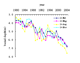
Fig.2 Buried depth of groundwater in Dayingpu observation
Besides, it also causes salinization on coastal area and other problems, leading to the deterioration of environment.
5 Countermeasures
5.1 Strengthen the cyclic utilization of water resources in garden
According to the number of workshop in fishery garden, the require water of each workshop and the times of changing water, the daily exploitation of water for fishery is estimated at 56.2 thousand m3. The used Salt well water drains to the sea directly, causing great waste of water resources. So the cyclic utilization of Salt well water must be strengthened to reduce the exploitation of groundwater. The facility for cyclic utilization of the Salt well water can be made experiments for a few workshops. If it runs well, all workshops should be demanded to fix the facility to use cyclic water in limited time. Correlating department can take some measures for the workshop owners who do not make it in time.
5.2 Building engineering establishment such as tidal barrage
The rivers near coastal area mostly separately flow into sea, the fountain of river is near and river flows quickly. The flood goes up and down suddenly and sharply after raining, and the utilization of river water is low, average at 30-40%.
5.3 Built the dynamic monitoring net of the salt well water
As liquid bed, the Salt well water is embedded in the loose deposition of Quaternary, which will change dynamically during the exploitation. Its change not only lies on its existing state, but also has a close relation with the influence from the outer nature during the exploitation, such as the exploitation, the characters of deposition of the wall rock layer of the Salt well water, the intensity of sediment pressure and the recharge. And it also has a certain influence of ups and downs of oceanic tide, the amount of precipitation seeping into terrenes, and direct relation with exploitation. Therefore, during the exploitation, it is necessary to pay attention to build the observing net to dynamic change of brine well, and to observe its change of water quantity and quality, which can make assurance to exploitation and protection of the Salt well water.
5.4 Control the aquiculture scale, enhance the unit output
In principle, the garden should be built along zonal coastline to avoid group develop and overdraw the underground Salt well water partly, which will make itself lack of water resource. The new workshop to utilize the underground Salt well water should be stopped to examine and approve in order to control the scale. The future industrial policy is not to spread the aquiculture scale, strengthen the science and technology of aquiculture and enhance the unit output.
6 Conclusions
(1)As a special groundwater resource in coastal areas, the Salt well water can provide a new water source for the mariculture.
(2)At present, the Salt well water resource of the research area, the fishery garden in Xingcheng city, is at the negative balance, so the exploitation scale and layout must be organized properly to strengthen the rational utilization of the Salt well water resources.
(3)The industrialized biology culture in coastal areas will certainly bring some impact on the coastal environment. So with the great economical benefit, some measures must be taken to minimize the influence on environment. It can never be done to sacrifice the human living environment to get the economical develop in return.
(4)This paper puts forward some countermeasures against the environment problems of the Salt well water exploitation. It will be a worthy reference for the scientific decision-making of the water department and all levels of government.
References
[1] Chen CX, Li GM (1996) Theory and model of groundwater solutetransport.
[2] Chen MX, Ma FS (2002) Groundwater Resources and environment of
[3] Du SY (2001) Chemical composition character and application in aquaculture of salt groundwater in Jiaozhou area. Thesis, Institute of
[4] Guo ZR, Huang YP (2003) Comprehensive Study on Seawater Intrusion. Hydrology 23(3):9-15
[5] Han YS, Meng GL, et al. (1996) Quaternary underground brine in the coastal areas of the Northern china. Science press,
[6] Jiang JL (2002) Study on Seawater intrusion to the sea-shore area of Huludao city. Hydrology 22(2):28-31
[7] Li JT (1989) Numerical simulation of ground water flow. Geological Press,
[8] Liu DJ (2004) The situation and analysis of salinity intrusion in coastal areas, china. Journal of geological hazards and environment preservation 15(1):31-36
[9] Liu YC, An XR, et al. (2006) Potential analysis of brackish water utilization in
[10] Ning JS, Yu ZG, et al. (2005) Chemical composition of underground brine in shore along
[11] Shi WL, Du Y. (2006) The application of the underground brine, salty water and surface salty water in aquaculture. Freshwater Fisheries 36(3):53-55
[12] Wang ZY, Meng GL, et al. (2003) Geochemistry modeling of quaternary subsurface brines in south coast of the
[13] Wei FY, Chen WX (2003) The Developing and Using of Salt Water on Aquatic Breeding in the Area of Panjin. Fisheries Science 22(1):45-46
[14] Xiao GQ, Pan LQ, et al. (2002) The study on the culture technology of Penaeus vannamei in underground brine water of low salinity. Marine Sciences 26(12):36-40
[15]
附作者简介:
Name: Ding Yuan-fang
Address:
Telephone: 13944172776 0431-8502147
E-mail: ding_yuanfang@163.com
作者简介:丁元芳(1981-),男,吉林汪清人,硕士生,主要从事地下水的信息化研究。
通信地址:吉林省长春市西民主大街6号 吉林大学 环境与资源学院 2004级硕(水文)
邮政编码:130026
电话号码:13944172776 0431-8502147
E-mail: ding_yuanfang@163.com
第二、三作者:迟宝明 兰双双