


Achievements
REPAIR WORKS FOR KARST WATER FLOWING INTO THE YUANLIANGSHAN RAILROAD TUNNEL, CHINA
Jiang Liangwen1, Yi Yongjin2, Yang Xiang3 & Tao Weiming4
1 The Second Railways Survey & Design Institute. (e-mail: teydkyjlw@263.net)
2 The Second Railways Survey & Design Institute. (e-mail: teydkyjlw@263.net)
3 The Second Railways Survey & Design Institute. (e-mail: teydkyjlw@263.net)
4 The Second Railways Survey & Design Institute. (e-mail: teydkyjlw@263.net)
Abstract: The Yuanliangshan tunnel is a key control project, which lies between
Key words: Karst, Level endless loop tape, water and mud-rock pouring up, Calamity, Repairing project, the TongmaLing Anticline, the YuanLiangshan Tunnel
General Outline of Geology and Geomorphology of the Tunnel
The special long tunnel of Yuanliangshan is the key control project of the planned railway, which lies between
The main geologic structure of running tunnel includes Maoba syncline and Tongmaling anticline and its associated or secondary faults; among which DK357+665~DK362+533 is Tongmaling anticline section constituded by the sedimentary of Cambrian (∈) and Ordovician (O)carbonate rock. The lithology is mainly classified as limestone, dolomitic limestone, lime dolostone, dolostone intercalated with thihbedded marl,shale and marl limestone. The axial portion of Tongmaling anticline cuts across the Qingshan, Genshan and Yudipo. It is
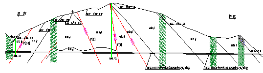
Fig. 1 Section sketch map of Tongmaling Anticline Section in Yuanliangshan Tunnel (proportion 1:10000)
Characteristics of Recharge, Runoff and Outflow of Karst Water in Tongmaling Anticline
The east and west wings of anticline are limited by non-soluble rock of Silurian System and their surrounding is cut by surface water system. The drainage base of karst water in Tongmaling is definded as the elevation of the soluble rock and non-soluble rock contiguous area which is cut across by surface water. In addition, surface watershed is almost consistent with underground watershed and the atmosphere precipitation is the only supply source for surface water and ground water.A line belt of Jianzishan (elevation
It is surveyed that the elevation of the interchange between
Above all, there is not integrated karst water system in anticline. Atmosphere precipitation is the only supply source for karst water. Besides forming surface runoff, most of atmosphere precipitation hides into underground and then forms karst groundwater runoff and finally drain to surface water system. The characteristics of recharge, runoff and outflow are: recharge dispersely by section, relatively integrated runoff along longitudinal crack-in-layer and transverse crack, and relatively integrated drain in the form of spring and ground river.according to each section and subsystem.
Hazards of Water and Mud-rock Pouring up in the West of Anticline Section of Construction Tunnel and its Analysis
Hazards of water and mud-rock pouring up during the construction
When the tunnel exit cuts across the east wing of the Dongmaling anticline to the core of karst water of vertical endless loop belt —→ season changed belt —→ horizontal endless loop belt—→sluggish stream belt in depth, the building encounter intense develop belt of the karst of east wing (i.e. pipeline network developed belt of the underground river or karst spring group), in addition too much of powerful rainfall. There were extensive water (sand,stones) pouring up time and again at the DK361+764,DK360+873,which cause lots of machines and tools buried or damaged, and the building tunneling met with obstruction seriously, We had to sustain tremendous loss in economy.
Analysis of water and mud-rock pouring up
Each spot of water pouring up at DK361+764, DK360+873, especially the spot at DK361+764, has the relatively obvious characteristics. During the construction the water pouring up appears: spraying pouring up water, turbid water, with plenty of mud and sand and also the initial water flow is extremely high, the duration time of flood peak is short, the water pouring up decreases sharply and trends to be stable and so on.
After sealed-block at DK361+764, water and mud-rock pouring up appear the characteristic of transferring.elsewhere, The Karst pipeline bedding collapsed along the right wall of the top of the cave at DK361+764, were sealed-block completely on Feb.11,2002.Then ground water was blocked up in the karst pipeline and consequently water level increases and hydraulic pressure augments. Finally, ground water, to find the way out, break the relatively failure rockmass on the left side of hance at DK361+764.(here originally a corrosion crack, Fig.3). Thus it successively caused two extensive water pouring up on Feb. 22,2002 and Mar. 3,2002 at the hance, the process of which carries lots of mud, sand and shiver stones. Afterward, the channel was seeled block by these shiver stones , mud and sand, only poured a little frature limpid water.Due to the reduction of counterpressure on the upper of the base and the weaker rockmass on the base of left wall breaked by the underground, the water pouring up bursted out around this area. Primary analysis indicated that the three sopts of karst water channel, such as the right side of the karst pipeline at DK361+764, the spot of water pouring up at the hance of the left wall and the base of left wall, should be closely connected to be the same water system. (Fig.2).
The analysis is indicated that the phenomena of water pouring up at DK361+764, from the initial intermittent, with airflow before 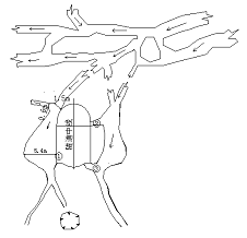
Fig. 2 Karst connection in DK361+764
climax, to many spots transferring afterblocke, and finally casting plenty of rocks from water exit, shows the karst water is completely developed, many branch-shape drainage networks exist, and the turnnel exposure the main pipeling natural karst non-directly.
Each time when extensive water pouring up from each spot at DK361+764,DK360+873 etc, the water will carry lots of mud, sand an shiver stones, content 35%. The carriers come from two parts, one is the fillings and sediments from original karst cave, underground river and karst pipeline; For exemple, at DK361+764 ~ +758 section, two big corrosion fractures are bedding developed. One of them is a frature closely to exit terminal (i.e. near the top of the cave), about
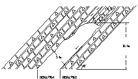
Fig. 3 Karst development on the right wall of Yuanliangshan tunnel
The other carrier comes from loose rockmass body of solution cavity. During the process of forming anticline of Tongmaling, through extruded ,and lately influenced by some tectonic movement. The rock body forms some horizontal veins. In addition, under the effects of efflorescence and corrosion, the rock is fragmentized, and the wall rock of solution cavity is loose, which can be carried during the process of forceful circulation and alternation of the ground water.
Each spot of water pouring up at DK361+764, DK360+873 section, if the surface without rainfall in a long time, the capacity of water pouring up will be small, stable and the water is almost limpid. When it is raining, especially after extensive rainstorm for several ten minutes~several hours, the capacity increase sharply and with lots of mud, sand or shiver stones. When last for several~ten hours or several tens hours, capacity will decrease sharply and trend to stability. For example, after one~two hours heavy rainfall on July.6,2002, an extensive water and mud-rock pouring up bursted out, instantaneous maximun is up to
Alternative repairing projects comparison
In order to guarrantee the safety of the tunnel building and its operation,and in view of the development of the karst and features of the poured up water and mud-rock and effect degree of the rainfall in the east wing of the anticline, We compare with the choice in the sluicing-hole drain, flat-guide drain, sealed-block and block-drain for the repairing projects about karst water (mud, sand, stones) pouring up in the east wing of the anticline ,describing as following respectively:
Sluicing-hole drain project
A sluicing-hole should be on the left
Flat-guide drain project
Flat-guide at PDK360+800~PDK362+574 section extends
Sealed-block project
Concrete, deliveried by high voltage pump, is used to seal-block all the karst capacities and pipelines at DK361+764, DK360+873~+950. Hydraulic pressure resistance linine is adopted to positive-hole at DK361+764 , DK360+873~+950 sections and corresponding flat-guide at PDK361+660~+820 and PDK360+820~+980 section, the intensity of flat-guide is slightly lower than positive-hole’s.
Block-drain project
Block-drain is defined as blocked karst pipeline by mud, sand and shiver stone to make clean water can pour in right quantity. In short, it means to drain water and reserve mud, sand and shiver stone.
Projects comparison
The sluicing-hole drain and flat-guide drain projects can avoid the water and mud-rock extensively pouring up in the scope of tunnel cave and their direct effects on tunnel cave and its lining cutting structure. But also the disadvangs exist. Arbitrarily draining the ground water and its belonging mud, sand and shiver stones, will influnce local entironment in the short term. It has the potential problems to make solution cavity further enlarge, and cause solution cavity and ground collapse. With respect to flat-guide project, due to the limitation of longitudinal slope, the carriers are so easy to fill up and there are lots of work lately to clean the silt.The application of flat-guide project will influnce the current construction of tunnel, discharge capacity, adverse to flat-guide as fire rescue access during the operation and reservation of double lines and still necessary to break a sluicing pipeline when building the dual lines.
The sealed-block project is adopted to make ground water find a new way out, so as to be balance again. If we can get the expected effect , there will be less trouble in the phase of railway operation. However, there are lots of unexpected factors when carrying out the project.If anticipative impact is reached, it will lessen a lot of trouble during the railroad operation. First of all, due to the influence by its high-pressure karst water, lining cutting structure is at risk; Secondly, in order to find a new exit, ground water may pouring up at the weaker position in the cave, while it is difficult to ensure the range of reinforcing lining cutting structure and Injection.
The block-drain project will neither cause lots of erosion of mud, sand and stones nor form the high hydraulic pressure, and neither threaten to tunnel lining cutting structure nor influence the entironment. It is the most reasonable in theroy. Howerer, under the current technological and equipment condition , it is difficult to realize. Sealed-block project has large in work quantities and the effect is influenced by the rock structure and technical reason.,and difficult to predict.Besides,after sealed-block, lining cutting will endure more hydrostatic pressure and both the constructed lining cutting built and flat-guide should be reinforced. In a word, the block-drain project is difficult in construction, big in engineering quantities, large in investmet, and that’s reason we adopt the drain project.
We compare time and again with the choices and finally adopt the sluicing-hole drain project. The advantages and disadvantages of each repair project see Tab.1.
Table 1. Correlation of the different regulatory programs
Plan | Environment Effect | Drainage Capacity | Constructive Difficulty | Operative Maintain | Structure Safety | Investment |
drainage plan for drainage hole | ①having a certain of effect on surface zoology environment ②the muddy with higher sands amount flows into | Satisfying flux and cut-and-fill requirements | Easy | Small amount of desilting | Safe | Larger |
Paralleling drainage plan | No satisfy the flux requirement, it is easy to fill up when rock dissolving with sands. | Easier | ①large amount of desliting ②having a certain of effect on paralleling firefighting function | Safe | Smaller (large investment when building complex line) | |
Ponding plan | No effect |
| Having a certain of difficulty | No maintain | Having risk | Large |
Plan combining ponding and drainage | No effect |
| Difficult | No maintain | Safe | Large |
Conclusion
When cuts across the east wing of the Dongmaling anticline, the building encounter the sector which develop an endless loop tape, in addition to much of powerful rainfall. There were extensive water and mud-rock pouring up time and again on the DK361+764,DK360+873,which cause lots of machines and tools buried or damaged, and the building tunneling met with obstruction seriously, We had to sustain tremendous loss in economy. In order to guarrantee the safety of the tunnel building and its operation,and in view of the development of the karst and features of the poured up water and mud-rock and effect degree of the rainfall in the east wing of the anticline, We compare with the choice in the sluicing-hole drain, flat-guide drain, sealed-block and block-drain for the repairing projects about karst water (mud, sand, stones) pouring up in the east wing of the anticline, and finally we adopt the first one;from October of 2002 to April of 2003, the project of sluicing-hole drain is constructed. The rainy season from May to September in 2003, Tongmaling anticline section in Yuanliangshan tunnel encountered powerful rainfall, and many sections such as DK 361+764; DK360+873 are suffered extensive water (mud, sand, stones) pouring up suddenly and continuously. Fortunately, the tunnel and lining cuttings are safe and sound by draining the water-mud-stones through sluicing hole. That indicates it is a correct choice to adopt the sluice hole project to renovate hazards of karst water pouring up from the east wing of anticline.
References
[1] ZHANG, Z.Y&WANG, S.T&WANG, L.S. The analyze theory of engineering geology. Geological Publishing House.
[2] The Second Railways Survey & Design Institute. Karst engineering geology. Chinese Railway Publ. Beijing 1984.
[3] The Karst Research group in Geological Institute of Chinese Scientific Academy. The Research of Chinese Karst. Scientific Publ. Beijing 1987.