


Achievements
CLIMATIC IMPACT TO WATER CONDITIONS IN THE UNSATURATED AND SATURATED ZONE OF CLAYEY ROCKS
J. Novotny 1, M.
Kohut 2, M. Mozny 2, V. Herbstova 1
1 Faculty of Science, Charles University of Prague, Czech Republic,
SG-Geotechnika,a.s., Czech Republic.
(e-mail: novotny@geotechnika.cz,Vladislava.Herbstova@seznam.cz)
2 Czech
Hydrometeorological Institute, Czech Republic. (e-mail: mojmir.kohut@chmi.cz)
Abstract: On the example of a model
locality built by Cretaceous mudstones of low permeability, specific properties
of the hydrogeological conditions of the saturated and unsaturated zone of
these rocks are presented in relation to climate. The assessment of mutual
relations between the climate and behaviour of the saturated and unsaturated
zone is based on the results of field measurements. The field data obtained
during several years of monitoring of the water conditions in the saturated and
unsaturated zone are confronted with the measured and calculated climatic
characteristics. The results of several years of intense observations are
confronted with long-term conditions.
Key words: mudstone, precipitation,
evapotranspiration, suction, piezometers, wells , monitoring, water stor
Introduction
To understand the climatic impact to the water conditions of
the rock environment is of basic importance for various fields of human
activity. It is of use, for example, in agriculture in relation to the solution
of irrigation problems, in hydrology when determining the run-off volume during
the assessment of risks of the climatic impact on the evolution of floods in a
given terrain, in hydrogeology to assess conditions leading to enrichment of
groundwater aquifer in given rocks and in engineering geology and geotechnics
with respect to stability conditions of water saturated slopes.
The model locality of a landslide area is at Trebenice in the
north-western region of the Czech Republic; it is one of model
localities in the country, where the water conditions of the saturated and
unsaturated zone have been monitored in relation to climate. This locality was
monitored due to vast landslide motions in Cretaceous mudstones that repeatedly
interrupted the railway traffic leading through this territory. The purpose of
this long-term monitoring was to study the relation between the climate,
hydrogeological conditions and the activity of landslides. In the framework of
this long-term programme, the relation of water conditions between the shallow
aquifer and unsaturated zone has been studied in this model locality of the
landslide area at Trebenice in the context of climatic conditions. Some results
of this monitoring are given in this article for the 1982 - 2005 period.
Conditions of
the Model Locality
The rock massif of the model locality of the landslide area at Trebenice
is formed by Cretaceous calcareous mudstones. Permeability of the shallow
aquifer in the subsurface zone of the rock massif was determined in this
locality by slug tests, carried out on the tips of the installed piezometers of
the Casagrande type at an interval of depths 2.5-10 m. The hydraulic
conductivity values, determined on the basis of hydrodynamic tests according to
Hvorslev (1951), are generally in the interval between nx10-10 to
nx10-8 m/s (Novotny 2005). The results of the performed tests
(Fig. 1) indicate vertical anisotropy of the shallow aquifer.
In depth 2.5 to 6 m below ground level, where highly weathered
up to decomposed mudstones were found with a limited occurrence of cracks,
hydraulic conductivity was generally found in the interval between 4×10⁻¹⁰ to
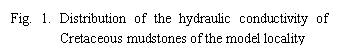
6×10⁻⁹ m/s. In weathered mudstones containing a system of
subhorizontal and subvertical cracks (Fig. 2), in a depth of
6 to 10 m below ground level, increased permeability was determined
by the field tests, in comparison with the overlying decomposed or highly
weathered zone, with hydraulic conductivity reaching 4 x10⁻⁸ m/s.
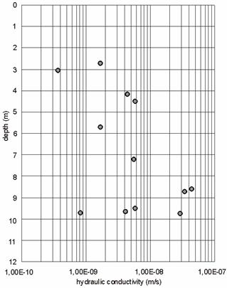
From the depths of more than 10 m below ground level, where weathered up to sound rock was found by drilling, the frequency of the system of subhorizontal and subvertical cracks decreases significantly, which also decreases the hydraulic conductivity. The permeability in the weathered and sound base is related to the local occurrence of tectonic failures along the more significant tectonic lines. The above-indicated anisotropic distribution of the permeability of the shallow aquifer can be related to the frequency of incidence of the system of subhorizontal and subvertical cracks that were formed during quaternary denudation as the result of unloading the overconsolidated massif, when up to several hundred meters of overburden rocks were removed at the site of the model locality. The determined vertical anisotropy of the hydraulic conductivity is typical for sedimentary rocks and was documented exceptionally also in other formations (Marechal et al. 2003, Cho et al. 2003). On the surface of the terrain of the model locality, the rate of infiltration was determined by the field and laboratory experiments. Depending on the degree of the soil saturation with water, its value is in the interval between n×10-6 and n ×10-4m/s.
Instrumentation of the model locality for the field measurement of the
water and climate conditions:
1. The water conditions in the saturated zone
The water conditions in the
saturated zone of the model locality of the landslide area have been monitored
since 1982 by monitoring of the fluctuations of the groundwater level in the
network of hydrogeologic observation wells of a depth 8-15 m. Positive pore
pressures have been monitored in the saturated zone since 1994 by measuring
piezometric levels in the installed piezometers of the Casagrande type in the
periodical or quasicontinual readings. The tips of the piezometers are located
in various depths from 2.7 to 10 m below ground level.
2.The water conditions in the unsaturated zone
The water conditions in the unsaturated zone have been monitored since
2003 by means of tensiometers, measuring instruments using the direct contact
method for measuring matric suction (see for example Fredlund & Rahardjo 1993). Matric suction in relation to the mechanical
behaviour of problematic soils has also been measured in stock-piles (Herbstova & Bohac 2005). The tensiometer tips are installed in the unsaturated
zone in a depth of 1 m and 2 m below ground level. When suction is
measured, the groundwater level is approximately 4-5 m below
ground level at the site of the installation of tensiometers.
3.The climatic conditions
The climatic conditions have been monitored directly in the Trebenice model
locality since April 2005, by means of an automatic climatic station that
serves for measuring meteorological elements necessary for the calculations of
potential, reference and actual evapotranspiration. All the climatic data that
are necessary for the climate long-term analysis within the submitted study,
were taken over from the nearby Doksany agrometeorological station.
4.Climatic data
The daily values of the
evapotranspiration of a standard grass surface were calculated in a daily step
for the 1982-2005 period by using the climatic data from the Doksany station.
These values were used together with the total precipitation for the
determination basic water balance of the pertinent area.
Under the basic water balance, we
understand the mutual difference between the total precipitation water and the
evapotranspiration of the grass surface or a hypothetical surface that is close
to the grass surface (Roznovsky & Kohut 2004). This balance is calculated
as a reference balance in accordance with the worldwide recommended FAO
methodology (Allen et al. 1998) or a potential balance (Thompson et al., 1981,
Hough et al. 1997). In both cases, this is the application of the modified
Penman-Monteith method. In this approach, potential water balance is involved because
the potential, but also the reference evapotranspiration represents the
maximally or almost maximally possible evapotranspiration. However, such water
balance does not express the real volume of water in the area, but serves as a
suitable indicator for mutual comparison of monitored locations or observation
years. The positive values of the water balance mean the excess, the negative
values mean the deficit of precipitation.
Results
Saturated zone
Time interval 1982-2005
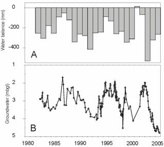
The course of the fluctuation of the groundwater level in the model
locality is indicated in Fig. 3B as an average from 10 monitored
hydrogeological wells in the 1982-2005 period. Pronounced oscillations are
obvious in the groundwater level that fluctuates not only seasonally, but also
in a longer interval of several years. Periods of several years of rising
groundwater level appear in general, when the enrichment of the shallow aquifer
prevails over the groundwater run-off or conversely, several years of groundwater
lowering prevails in general, when the groundwater run-off exceeds the
enrichment of the groundwater aquifer. These oscillations are in accordance
with the general climate changes (Fig. 3AB). The last period of the significant
culmination of groundwater levels was 2002.
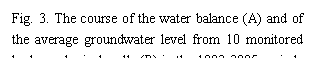
Time interval 2003-2005
The period from 2003 until 2005 was evaluated in more detail
(Fig. 4). In this period, gradual groundwater lowering is obvious. Significant
lowering was recorded primarily in the course of 2003. The lowering was smaller
in 2004, 2005 is typical by the year-round stagnation of the groundwater level
at approximately the same level. It is obvious from the comparison of Fig.
3 with Fig. 4 that the groundwater aquifer lost water from the condition of the
long-term maximum to the long-term minimum.
The maximum-recorded groundwater lowering during 2003-2005 was 6 m
in some monitored hydrogeological wells; on the other hand, part of
the wells exhibited mild lowering of about 1 m. In general, higher
oscillations of positive pore pressures were obvious in piezometers with tips
installed in depths 3-5 m below ground level, when the pore pressure
decreased in a difference up to 40 kPa. Deeper piezometers with tips 7-10 m below
ground level generally recorded a pressure difference of 10 kPa during general
lowering.
Fig. 4 The course of the water balance (A), suction (B,C), average groundwater level and pore pressures (C) in the 2003-2005 period
Unsaturated zone
Tensiometers with tips 1 m below ground level exhibit significant oscillations of the matric suction (Fig. 4B). The largest suctions were measured in a depth of 1 m below ground level from the summer to autumn seasons, when they reach 80 to 90 kPa. The value of the suction pressure of -90 kPa is the limit of the measuring capacity of tensiometers. At higher suctions, there is the effect of cavitation of the water column in the measuring instrument (see for example Fredlund & Rahardjo 1993, Herbstova & Bohac 2005). The real matric suction may therefore be higher in the summer and autumn season, however, it is not measurable with this type of tensiometers. A sudden drop of suction to zero value occurred in January to February 2004 and 2005 within 1-2 months. In April (May), the suction started to increased from zero value.
In comparison with tensiometers
with the tips at a level of 1 m below ground level, lower suction
pressures were recorded with the tips at a level of 2 m below ground
level (Fig.4C). The maximum suction was recorded in the winter months. At the
turn of 2003/2004, matric suction pressures of -25 to -45 kPa were measured, at
the turn of 2004/2005, suction pressures of -55 to -70 kPa.
The suction does not decrease suddenly as in the zone 2 m under the terrain. The suction decreases measured in May. In this period, the suction pressures gradually from a maximum to minimum during a period of 4-5 months. The minimum suction was decrease to -10 up to -20 kPa; contrary to the 1 m zone below ground level, they do not decrease to zero. In a depth of 2 m below ground level, there is a trend of suction growth in the 2003-2005 period that is related to the deficit trend in the water balance in this period (Fig. 3A). In the records of tensiometers with the tips 2 m below ground level, the time delay of the suction minima is 2-3 months behind the same suction minima in depths of 1 m below ground level. The delay in the transfer of humidity in the soil profile is also caused by a low unsaturated hydraulic conductivity that is distinctively dependent on the degree of soil saturation. With the growing matrix suction and decreasing degree of saturation, the unsaturated hydraulic conductivity decreases and the response of deeper tensiometers to precipitation events is therefore delayed.
Climate
Time interval 1982-2005
The climatic situation was assessed for the 1982-2005 period (Fig. 3A and
Fig. 5AB). In the 1982-2005 period, the values of the monthly averages of the
basic humidity balance have a very distinct course during the year with high
negative values in the summer half of the year (Fig. 5B). The monthly averages
of the data from April to August are balanced. The situation is more favourable
in the winter or autumn period, with the positive water balance.
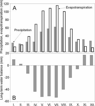
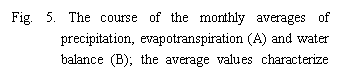
In the course of the monitored 1982-2005 period, the potential
(reference) evapotranspiration prevailed regularly over precipitation with one
exception in 2001, when a positive water balance was achieved (Fig. 3A).
In comparison with the monitored 1961-2000 period, the analyzed 1982-2005
period has less precipitation; on the contrary, the values of the potential and
reference evapotranspiration are more distinct. It follows from these facts
that the basic water balance of the 1982-2005 period is less favourable from
the long-term point of view with a mild deficit of precipitation and larger
evaporation by about -44 mm. The groundwater storage follows this climatic
situation; in general, there was a mild trend in groundwater lowering in the
monitored 1982-2005 period (Fig. 3B).
Time interval 2003-2005
The following facts were obtained from the detailed evaluation of the
course of the monthly total precipitation and potential evapotranspiration of
the standard grass surface during 2003 – 2005. In the vegetation period,
primarily from May to September, potential evapotranspiration prevails over
precipitation in the absolute majority of cases. The largest differences were
recorded primarily in 2003-2004. Here it is necessary to draw attention
primarily to the very high monthly values of the potential evapotranspiration
in June, July and August in the very dry period of 2003. The current data of
the evapotranspiration are not so extreme in view of the fact that nothing was
left for evaporation (precipitation deficit and the low humidity of the soil
mantle). Conversely, in the cold half of the year (primarily winter
months), both meteorological elements are more or less balanced and in the
absolute majority of cases, precipitation in form of rain or snow prevails over
evaporation. This fact is also obvious during the evaluation of the basic water
balance (Fig. 4A). The trend of the course of the water balance
corresponds well to the change of suction at a depth of 1 m below
ground level. In greater depths, the time delay of the humidity progress behind
the climatic impulse becomes obvious.
Conclusion
The state of the groundwater storage in the shallow aquifer in
Cretaceous mudstones with low permeability changes with time in dependence on
climatic conditions. In the mild climate, oscillations of the groundwater level
appear in various hierarchic levels: Interval – day, season, several years,
several tens years. In the evaluated period 1982-2005, there is in general mild
groundwater lowering, the maxima of several years are related to 1987,
1995-1997, 1999 and 2002.
In the mild climate, primarily precipitation of the very late autumn and
the snow precipitation in winter months are decisive for increasing the
groundwater storage of Cretaceous mudstones; this becomes obvious after
defrosting in the period of the spring snow-melt. Total precipitation in
warm summer months do not contribute significantly to the growth of the
groundwater storage with respect to their high loss due to evapotranspiration
and in part also by surface run-off.
The water transfer from the surface to the groundwater level is affected
by the gradually growing delay of the order of magnitude of several months,
caused by the low permeability of the subsurface zone that decreases
significantly with the decreasing degree of the water saturation above the
groundwater level.
Acknowledgement
This contribution was supported from the grant of the Grant Agency of the Czech Republic No. 205/05/2188.
References
[1] Allen R.G., Pereira L.S., Raes D., Smith M., 1998: Crop
evapotranspiration. Guidelines for computing crop water requirements, FAO
Irrigation and Drainage Paper 56, Rome, 300 p.
[2] HerbstovA, V., BohAC, J., 2005: Laboratory investigation of the
collapsibility of a clayey spoil heap soil. In Proc. GEOPROB 2005 -
Int. Conf. on Problematic Soils. Famagusta, Cyprus, Vol. 2., 715-722.
[3] Hough M., Palmer M., Weir A., Lee M., Barrie I., 1997: The
Meteorological Office Rainfall and Evaporation Calculation System. MORECS
version 2.0 (An update to Hydrological Memorandum 45). Meteorological
Office, Bracknell, 82 p.
[4] Hvorslev,M.J., 1951: Time lag and soil permeability in groundwater
observations. US Army Engineer Waterways Experiment Station, Vicksburg, Miss. Bull.
No. 36, 1-50
[5] Cho,M., Ha,K., Choi,Y., Kee,W., Lachassagne,P., and R. Wyns, 2003: Relationship
between the permeability of hard-rock aquifers and their weathered cover based
on geological and hydrogeological observation in South Korea. Groundwater
in Fractured Rocks (2003) – Prague, Czech Republic,
Krasny-Hrkal-Bruthans (eds), 41-42.
[6] Fredlund, D.G. and Rahardjo, H., 1993: Soil Mechanics for
Unsaturated Soils. John Wiley and Sons Inc. New York
[7] MarEchal,J., Wyns,R., Lachassagne,P., and K. Subrahmanyam, 2003: Vertical
anisotropy of hydraulic conductivity in hard-rock aquifers. Groundwater
in Fractured Rocks (2003) – Prague, Czech Republic,
Krasny-Hrkal-Bruthans (eds), 73-74
[8] Novotny, J., 2005: Hydrogeological conditions of shallow aquifer in
Cretaceous claystones in view of engineering geology. 7th Hellenic
hydrogeological conference, 167-173, Athens, Greece
[9] RoZnovsky J., Kohut M., 2004: Drought 2003 and potential moisture
balance. Contributions to Geophysics and Geodesy. Vol. 34/2,
195-208
[10] Thompson N., Barrie I.,
Ayles M., 1981: The Meteorological Office Rainfall and Evaporation
Calculation System: MORECS (July 1981). Hydrological Memorandum No. 45,
Meteorological Office, Bracknell, 72 p.