Achievements
GROUNDWATER RECHARGE IN THE BADAIN JARAN SHAMO, INNER MONGOLIA, P.R. CHINA
GU Wei-zu1, SEILER Klaus-Peter2,
STICHLER Willibald2, LU Jia-ju3
1Hohai University, Nanjing, P.R. China
2GSF, National Research Centre, Neuherberg, Germany
3Nanjing Institute of Hydrology and
Water Resources, Nanjing, P.R. China
Abstract: Inner Mongolia is going to
develop the Badain Jaran Shamo and the adjacent grass lands of the Gobi.
In this effort it is essential to quantify natural as compared to man made
desertification, especially groundwater gains and losses. With this information
appropriate groundwater management strategies can be developed. - Groundwater
of the Badain Jaran Shamo flows predominantly in fissured rocks from south to
the north and has low flow velocities. - From meteorological stations around
the Badain Jaran Shamo mean precipitation has been extrapolated to
70-100mm/year; in contrast pan evaporation accounts in the warm season for
about 4000mm/year and declines significantly during the cold season;
therefore, as an average it is assumed that yearly actual evaporation from
lakes and wetlands exceeds about 30 times precipitation. Since the high
evaporation areas of the Badain Jaran Shamo are in the south-east and
groundwater slopes from south to north, a simple water balance shows that local
groundwater recharge cannot cover all evaporative water losses. - The
evaluation of stable isotopes of the water molecule shows that most groundwater
has an evaporation signature from lakes and the small wetlands; however, there
are also – albeit scarce - recharge contributions without evaporation
signature. - Lake levels vary according to seasonal variations of
evaporation; any groundwater level variation related to the very small
groundwater recharge is considered negligible, because of the high porosity of
aeolian sands. Hence, in summer strong evaporation losses exceed groundwater
inflow to the lakes, decline the lake and groundwater table and lowers by
isotope fractionation the deuterium excess of lake water; in contrast, during
winter the groundwater/lake level is rising, because of a stronger
non-evaporated groundwater inflow than evaporative water consumption from
lakes, and therefore the deuterium excess of lake water increases in winter
time. - Stable isotope variations at constant deuterium excess occur in springs
and dug wells close to lakes; these variations have been evaluated as compared
to the respective variations in precipitation to account a mean residence time
of 6years. - All lakes have tritiated water (maximum 20TU), because of a
locally high tritium level in atmospheric moisture, and have high DOC contents,
>>2mg/L C; in contrast groundwater, which is not influenced by lake water
has low tritium (1<TU<5) and DOC (<<2mg/L C) contents; this should
be considered in applying the Cl-groundwater-balance method for groundwater
recharge studies. Groundwater recharge according to the Cl-input (about 2 mg/L)
and output amounts to 1.5 to 1 mm/year. 14C dating
leads to water ages from present to about 30,000years at shallow depth; hence
groundwater flow has an actual and fossil recharge component; actual recharge
forms a thin groundwater cover above historic and fossil recharge. The whole
system belongs basically to a transient discharge system since historic and
geologic time scales. Taking old shore lines of lakes above the actual sea
levels and 14C dating of it results in a decline of about 1mm/year
over the last 10,000years; over the run of 30,000years, this decline can be
approximated as exponential and thus allows an extrapolation to any near future
development.
Key words: Groundwater recharge, environmental tracers, groundwater dynamics,
groundwater dating
1 The task
Today’s China has a desert area of about 370,000km²,
accounting for about 8.5% of its territory, and extending during historical and
geological times by desertification. As in many other areas of the world,
desertification has a geologic/historic, non-man-made background and became
accelerated by men’s activities since the mid of the 19th century.
Desertification is documented by land drying, vegetation changes, wind erosion,
sand accumulation, and soil and water salinization. All these phenomena threaten
people’s local economy, health and safety and make a region still more
vulnerable to draughts, floods, wind and sand storm disasters as it already is.
In between the many aspects of desertification, our project concentrates
l To the Badain Jaran Shamo area and the adjacent grasslands (Fig. 1),
which already has been studied by Chinese and international research groups
(e.g. YU et al. 1962, ZHOU et al. 1986, DAVIS 1986, WALKER et al. 1987, GHEY et
al. 1996, JÄKEL 1996, HOFMAN 1999), hence has already a good, but still
non-sufficient data base to develop groundwater management strategies, and
l The natural desertification processes in these two areas during the past
millennia and the actual and future consequences for the water resources.

Fig. 1 The Badain Jaran Shamo in Inner Mongolia with the Gurinai and Ongt Gol grasslands in the north-west respectively north. The red circle indicates the research area of the years 2004/2005, the white arrow a general groundwater flow direction beneath the sand sea.
The present stage of the project intends to
l To contribute to the actual groundwater balance,
l To account for any groundwater inflow to the desert and grassland areas
from neighbouring regions,
l To study the decline of the water resources in the Badain Jaran Shamo
during the past millennia and
l To extrapolate such natural developments to the near future.
Special instruments to be used are space and time integrating methods in
combination with traditional hydro-geologic investigations.
l On the small scale field works provide mostly instantaneous results;
l On the large scale satellite imaging delivers space and environmental
tracer methods space and time integrating results.
Satellite imaging provides data over the last 50 years, environmental
tracer methods data over the past millennia till recent years. In this research
it is a special favour that groundwater chemistry in
the Badain Jaran Shamo is not yet influenced by human contamination sources,
except some radioactive environmental isotopes, which may have the signature of
an actual air contamination, because the Badain Jaran Shamo and adjacent areas
are a nuclear exercise area of the PR China. In between these radioactive
isotopes Tritium with a half life of only 12.3years may be considered a
valuable tracer, because it allows under special boundary conditions to
qualitatively recognize actual groundwater recharge; the disadvantage of the
radioactive air pollution is that 3H can’t be used properly to
quantified groundwater recharge (SEILER & GAT 2007), because the input
function is unknown, hence any comparison with the output function is
impossible.
2 Geologic and Hydrogeological Settings
2.1 Geologic settings
The Badain Jaran Shamo is situated between E 100° to E 106° and N 40° to
N 42° (Fig. 1) and reaches altitudes of 1,200 and 2,000 m a.s.l.. In
its S and mostly SE part it has many small lakes. The regional geologic and
tectonic setting of this area was detailed by HOFMANN (1999). The
characteristics of the Badain Jaran Shamo are low and huge sand mountains and
exceptionally scarce outcrops of any bed rocks (JÄCKEL 1996). Therefore, little
is known about the pre-existing morphology and the bed rock geology of the
Badain Jaran Shamo, covered both by aeolian sands. However, bathymetry of
lakes, microbiolite islands and springs in lakes make sure that many lakes are
in close contact with consolidated fissured rocks.
1. Recent bathymetric measurements in the Lake Noertu (Fig. 2) and other
deep lakes suggests that the lake underground is build up by consolidated
rocks, because the slopes of the lake floors are often too steep (>>36°)
for unconsolidated rocks.
2. In some lakes carbonate islands (microbiolites) occur, which have been
described by ARP et al. (1996). On top of these islands springs may discharge
(Fig. 3), indicating a hydraulic head of these springs above the lake level;
such springs can only refer to groundwater in wide fissures of consolidated
rocks (SEILER 1968).
3. In other lakes, springs discharge like little fountains into the shallow
part of the lake; this also indicates a hydraulic head above the lake level,
hence, groundwater flow in fissured rocks (Fig. 4).
Mother materials of the sand mountains are preferentially silicate rocks
because the sand consist basically from quartz and silicates with very few or
even missing carbonate rocks. The large grain sizes of Aeolian sands (0.2 to 0.6mm)
in the sand mountains further suggest that the source and sink areas of sands
cannot be distant.
Since the geology of the Badain Jaran Shamo is not very well known
(WALKER et al. 1987, ZHENG et al. 1982), no precise answers can be given on the
question if the sands are covering a mountain or are sitting as huge dunes on a
flat and perhaps weathered old landscape. It was suggested that the sands are
positioned as dunes on clays and that these clays act as an outflow horizon for
dune infiltration (JÄCKEL 1996, HOFMANN 1999); as compared to the water
balance, however, this interpretation seems to be questionable.
2.2 Groundwater table and subsurface
water flow in the Badain Jaran Shamo
Groundwater levels have been measured during the 2002, 2004 and 2005
excursions using GPS; although GPS measurements of altitudes have no high
precision and the groundwater surface is always uneven in hard rock aquifers,
these results allow nevertheless some basic statements: Yearly repetition of
measurements differ by less than 2m, groundwater flow is directed from
south to north (Fig. 5) or south-east to north-west and in the investigated
south-east of the Badain Jaran Shamo, the border area, the water table slopes
steeper than in the central part of the desert. The latter observation could be
interpreted in terms of individual inflow areas of fresh groundwater into the
desert, which widen like a delta, thus producing the flat groundwater table in
the inner part of the Badain Jaran Shamo; in other words groundwater flows from
small to huge cross-sections on the way from south to the north. If this
interpretation can be approved by more precise and extended measurements, it
resulted in two statements:
l Groundwater flow velocities in the south-east must be higher than in the
central Badain Jaran Shamo and
l Groundwater residence times in lakes and, hence, mineralization by
evaporation are higher respectively stronger in the inner part of the desert
than in the south-east.
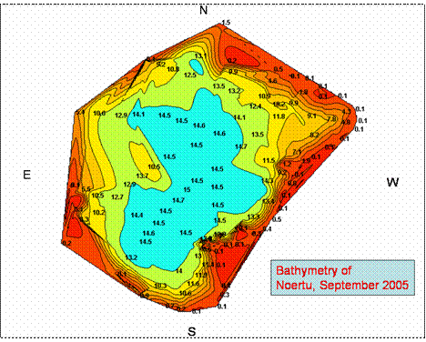
Figure 2 Bathymetry of the Noertu
lake in the Badain Jaran Shamo (September 2005;
measurements by EarthWatch volunteers)
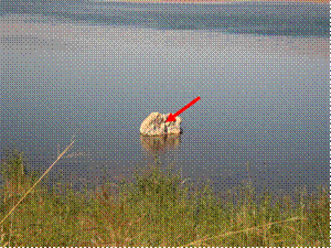

Fig. 3 A spring on top of a
carbonate island in the Lake Noertu, Badain Jaran Shamo. The
hydraulic head of this spring lies above the lake level. Left photo: the red
arrow indicates the position of the spring; right photo the artesian outflow of
the spring on top of the island
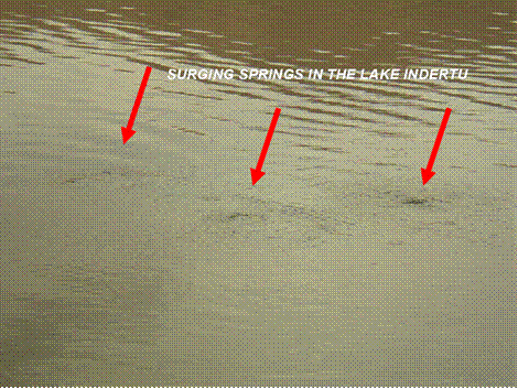
Fig. 4 Three springs discharging like a
fountain into the shallow part of the Lake Indertu, Badain Jaran
Shamo. The hydraulic head of this spring lies above the lake level
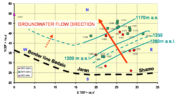
Fig.5 Groundwater counter map from GPS water level measurement during the years 2002, 2004 and 2005
The expeditions to the Badain Jaran Shamo made clear that lake levels
obviously undergo variations as indicated during summer by the missing
vegetation along the actual littoral zone of the lakes. Since lake water is
uncovered groundwater, such variations can be attributed either to seasonal
variations of the intensity of evaporation (E) or groundwater recharge
variations. Precipitation accounts to about 70-100 mm/year, summer
evaporation amounts 4000mm/year and the sand cover of the fissured aquifer
has high porosities; therefore the little groundwater recharge (70-Eactuel or
100-Eactuel) cannot produce significant groundwater table fluctuations. These
variations are most probably due to seasonal changes of the intensity of lake
evaporation as compared to the small amounts of groundwater inflow to the
lakes. Lakes act in the warm season as a complete and in the cold season as a
partial sink for groundwater fluxes; therefore, monthly observations of stable
isotopes of the water in the lake Cahachulutu (Fig. 6) show that the deuterium
excess declines in the summer and increases in the winter season, because in
summer evaporative water losses exceed groundwater inflow and in winter
groundwater inflow exceeds evaporation losses and thus dilute the summer deuterium
excess.
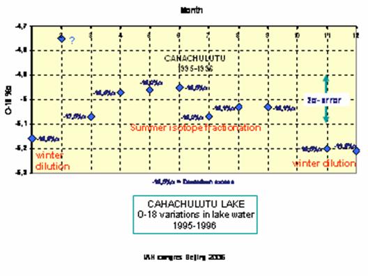
Fig. 6 Stable isotope
variations in the Cahuchulutu lake over the run of a year
Groundwater level fluctuations have not yet been investigated in the
study area. In contrast stable isotope variations have been observed during one
year in the groundwater close to the Shuqui Lake (Fig. 7). The
deuterium excess is constant all over the year but the stable isotope content
varies. This variation as compared to the respective stable isotope variations
in precipitation can be used to approximate the mean residence time (t’):

For the Shuqui groundwater a mean residence time of 6.7years results,
which is quite short as compared to the relief energy, characterizing the study
area; this can, therefore, only be interpreted as a high portion of
preferential fluxes contributing in the unsaturated zone of sands to
groundwater recharge (SEILER et al. 2002).
2.3 Chemical and isotope
characteristics of Badain Jaran Shamo Groundwater
Groundwater in the Badain Jaran Shamo belongs either to fresh or saline
water:

Fig.7 Stable isotope
variations during the year in the groundwater close to the Shuqui Lake.
l If it did not undergo evaporation at open water surfaces, it is fresh
and has a pH close to neutral (pH 7.5) or
l If it underwent serious evaporation in lakes pH rises to 9 or 10 and
lake water appears saline.
Main chemical constituents of waters from the Badain Jaran Shamo are
sodium, chloride and sulphate Tab. 1. The most surprising result, however, are
high DOC concentrations in groundwater although there exist no soil cover. The
high DOC concentrations (>2mg/L C) are attributed to the high number of
organisms in all Badain Jaran Shamo lakes; this allows to distinguish between
groundwater in contact with lakes (DOC>>2mg/L C) and groundwater without
(DOC<<2 mg/L C) and thus to apply also the chloride groundwater
balance method to calculate groundwater recharge from areal infiltration to
groundwater. As shown by the short mean residence time of groundwater from
infiltration to detection time, preferential flow seams to be an important
factor to protect infiltrates from evaporation. This can be confirmed by stable
isotopes (Fig. 9) and by observations of the water content/saturation in sand
dunes, which is even high close to the land surface (Fig. 8).
With the actual analytic results on groundwater chlorides and supposing
a Cl-input concentration with precipitation of 1mg/L and a mean precipitation
amount of 70-100mm/year resulted in 1 to 1.5mm/year of groundwater
recharge, which is close to the experience of many desert areas the world
around (SEILER & GAT 2007).
Nearly all groundwater have either an evaporation signature (Fig. 9)
from the land surface or represent a mixture between evaporated lake and
non-evaporated infiltration water. As compared to precipitation, groundwater
recharge occurs in all seasons, however, winter seams to be the main recharge
season; this recharge is probably linked to snow melt, which contributes more
efficient to ground water recharge than rain infiltration.
Only few samples have a measurable tritium content (Fig. 9), because either present groundwater recharge is focussed to a thin layer close to the groundwater surface or most samples belong to historic (<10,000years) or fossil (>10,000years) groundwater recharge.
Table 1 Results of chemical
analysis from lakes (L), springs (S), shallow drills (sd) and dug wells (dw) in
the
Badain
Jaran Shamo. n.d. = not detected. Brown = exceptionally high values, green =
normal values
|
Place/ date |
As µg/L |
Na+ mg/L |
K+ mg/L |
Mg++ mg/L |
Ca++ mg/L |
NH4+ mg/L |
NO2- mg/L |
NO3- mg/L |
F- mg/L |
Cl- mg/L |
SO4-- mg/L |
DOC mgC/L |
|
Detection
limit |
5 µg/L |
0.5 mg/L |
0.25
mg/L |
1 mg/L |
5 mg/L |
0.05 mg/L |
0.5 mg/L |
1 mg/L |
0.1 mg/L |
2.5 mg/L |
5 mg/L |
0.5 mg/L |
|
|
|
|
|
|
|
|
|
|
|
|
|
|
|
NRT(S) 02-09-25 |
911 |
84451 |
4100 |
133 |
3040 |
n.d. |
n.d. |
n.d. |
n.d. |
73978 |
11405 |
6.8 |
|
NRT 02-09-25 |
n.d. |
266 |
59.0 |
22.5 |
33.0 |
n.d. |
n.d. |
14.2 |
6.7 |
137 |
164 |
2.4 |
|
HGN 01-09-25 |
n.d. |
137 |
20.3 |
67.8 |
26.6 |
0.39 |
0.50 |
n.d. |
3.6 |
104 |
21.1 |
2.8 |
|
ZEGT(S) 00-09-26 |
n.d. |
608 |
16.9 |
15.2 |
7.28 |
n.d. |
n.d. |
18.8 |
n.d. |
337 |
243 |
2.8 |
|
HBT 02-09-29 |
n.d. |
427 |
48.1 |
133 |
91.2 |
n.d. |
1.70 |
n.d. |
n.d. |
245 |
407 |
19.2 |
|
Lutu (sd) 02-09-27 |
n.d. |
574 |
43.2 |
115 |
78.4 |
n.d. |
n.d. |
n.d. |
n.d. |
n.d. |
377 |
3.1 |
|
Lutu (IR) 02-09-27 |
n.d. |
150 |
1.9 |
129 |
34.2 |
n.d. |
n.d. |
n.d. |
n.d. |
100 |
59.0 |
3.3 |
|
Lutu (S) 02-09-27 |
n.d. |
400 |
26.4 |
89.9 |
59.6 |
n.d. |
n.d. |
n.d. |
n.d. |
265 |
280 |
5.4 |
|
Lutu (L) 02-09-27 |
n.d. |
196 |
18.1 |
53.8 |
51.8 |
n.d. |
n.d. |
n.d. |
n.d. |
149 |
123 |
2.8 |
|
Dw A |
|
|
|
|
|
|
|
|
|
|
|
15.8 |
|
SGIL(S) 00-09-26 |
n.d. |
276 |
12.2 |
n.d. |
12.5 |
n.d. |
n.d. |
8.40 |
1.2 |
88.3 |
153 |
0.7 |
|
SGIL(DW)00-09-26 |
n.d. |
102 |
12.3 |
n.d. |
n.d. |
n.d. |
n.d. |
6.49 |
1.7 |
69.8 |
111 |
1.2 |
|
Indertu (holy Spring) 22-10-04 |
|
|
|
|
|
|
|
|
|
|
|
<0.2 |
|
Luerto 27-09-04 |
|
|
|
|
|
|
|
|
|
|
|
<0.1 |
|
Spring 29-09-04 |
|
|
|
|
|
|
|
|
|
|
|
<0.2 |
14C analysis on water samples
from springs and dug wells gave water ages from present to 30,000years. The
very old, shallow groundwater is not supposed to belong to sand dune recharge,
but to long and shallow flow paths from outside the desert.
2.4 Long term groundwater level
decline
In the Badain Jaran Shamo old shore lines have been found, occurring
about 40m and less above the actual lake levels (HOFMANN 1999). These
shore lines contain organic matter, carbonate shells and carbonate
precipitates, which have been dated with 14C. Snails from these
high positioned shore lines (e.g. Planorbis) indicate further former lake
salinities, which were lower than actual. The correlation of these former
altitudes and the respective ages of shore lines indicates in a first
approximation an exponential decline of groundwater/lake water tables. This
correlation must be extended to investigate if this decline was continuous and
refers to a hydraulically buffered system (transient system) or if the known
climate changes at the end of the last ice age and the climate optimum about
5,000 years ago makes this decline discontinuous.

Fig. 8 Water saturation
in aeolian sands of the Badain Jaran Shamo as a function of depth beneath
ground
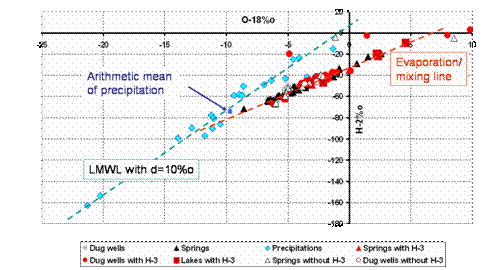
Fig. 9 2H/18O diagram of water samples
from the Badain Jaran Shamo. Some springs group along the local meteoric water
line (blue), some along an evaporation line (red), starting from δ18O=-11.9%o
and δ2H=-83.2%o on the LMWL
3 Conclusion
Main aquifers in the Badain Jaran Shamo are fissured, most probably
crystalline rocks; hard rock outcrops in this area are scarce. The large grain
sizes of dune sands and the conservation of many stone-age tools stand for
short aeolian transport distances of sands from the source and the sink area.
Groundwater flows from adjacent areas in the south to the Badain Jaran
Shamo; it is actually also recharge in the desert by about 1 to 1.5mm/year. 14C-data
as compared to 3H-data indicate that actual groundwater recharge forms a very thin
cover over old groundwater (1,000 to 30,000years). Both cross in north and
north-west direction the Badain Jaran Shamo to reach the grassland. The
infiltration process of actual groundwater recharge seems to be mostly produced
by preferential flow, because mean residence time calculated by comparing
stable isotope variations in groundwater as compared to precipitation yields
residence times of only 6 years in an area with high relief energy.
Groundwater in contact with lakes is traced by
high DOC contents from the huge number of organisms in the lakes; this DOC
signature allows distinguishing between groundwater with and without lake
contact, being important in applying the Cl groundwater balance method. Stable
isotopes indicate that most groundwater is evaporated, following one individual
evaporation line, which starts from winter precipitation; however, there are
also summer infiltration events of non-evaporated water.
Acknowledgement
The authors wish to express their high appreciation to the EarthWatch
Institute in Boston that supported this research by sending
volonteers for our field campaigns.
References
[1] ARP, G., HOFMANN, J. & REITNER, J. (1998): Microbial fabric
formation in spring mounts (Microbialites) of alkaline salt lakes, Badain Jaran Sand Sea,
PR China. – Palaios 13, 581-592
[2] GEYH M A, GU WEI-ZU, JAECKEL D. (1996): Groundwater recharge study in
the Gobi desert. – China J. Geosciences 7/8, 279-280
[3] HOFMANN, J. (1999): Geoökologische Untersuchungen der Gewässer im Südosten
der Badain Jaran Wüste (Aut. Region Innere Mongolei/VR China) – Status und
spätquartäre Gewässerentwicklung. – Berl.Geogr. Abh. 64, 5-247
[4] JÄKEL, D. (1996): The Badain Jaran desert: Its origin and development. –
Geowissensch. 14, 272-274
[5] SEILER, K.-P. (1968):
Kluft- und Porenwasser im Mittleren Buntsandstein des Südlichen Saarlands. –
Geol. Mitt. 9, 75-96
[6] SEILER, K.-P. & LINDNER, W. (1995): Near surface and deep
groundwater. - J. Hydrol. 165, 33-44
[7] SEILER, K.-P. & GAT, J.R. (in preparation): Groundwater
recharge from run-off, infiltration and percolation. - Springer
[8] SEILER, K.-P.,
LOEWENSTERN v., S., SCHNEIDER, S. (2002): Matrix and bypass-flow in quaternary
and tertiary sediments of agricultural areas in south Germany. - Geoderma
105, 299-306
[9] WALKER, A.S., ALSEN, J.W. & BAGEN (1987): The Badain Jaran desert:
remotte sensing investigations. – The Geogr. J. 153, 205-210
[10] YU, S., LI, B., CAI, W.Q., & TAN, J.N. (1962): A survey of the Gobi
of Western Inner Mongolia and Badain Jaran Desert. – Nation. Techn. Information
Service Pub. JPRS 19993, 244-276
[11] ZHENG, Z. et al.
(1982): Stratigraphischer Überblick über das Badain Jaran Gebiet, Innere Mongolei. – J. Stratigr. 6, 225-230
[12] ZHU, Z., LIU, S., WU, Z. & Di, X. (1986): Deserts in China. – Inst. Desert Research, Lanzhou, 1-131


