


Achievements
GROUNDWATER RECHARGE RATES TO THE BADAIN JARAN DESERT: PRELIMINARY RESULTS FROM ENVIRONMENTAL TRACER STUDIES
John Gates1, W. Mike Edmunds1 and Jinzhu Ma2
1 Oxford Centre for Water
Research, University of Oxford
2 Key Laboratory of Western China’s
Environmental System, Lanzhou University
Abstract:We report here on new findings of groundwater tracer studies in the Badain Jaran Desert, Inner Mongolia, China. Shallow groundwater is ubiquitous in the desert’s low-lying areas, and supports numerousinterdune lakes despite hyper-arid conditions. With increasing pressure on the region’s water resources, a clear understanding of this hydrological system will be essential for effective water management strategies.
During field
sessions in 2004 and 2005 approximately 30 groundwater samples for chemistry
and stable isotope analysis were collected across the southeastern section of
the Badain Jaran and areas adjacent to the main dune field to
the south and southeast. In addition, one unsaturated zone profile was
collected by hand auger in order to estimate direct recharge using mass balance
of chloride. Profile results indicate that diffuse recharge in the Badain Jaran is
low though nonzero (approximately 1 mm/yr), and somewhat variable in space
and time. This result confirms that modern direct recharge is insufficient to
support the desert lakes. Shallow desert groundwaters are isotopically distinct
from the region’s modern rainfall as well as shallow groundwaters of
locations immediately to the south of the desert. The lakes are shown to derive
from shallow groundwater, related along an isotopic evaporation line with slope
of 4.2.
Major ion
chemistry and stable isotopes suggest a pre-modern origin for the shallow groundwaters,
with recharge occurring during wetter climatic conditions during the
Pleistocene or humid phases of the Holocene. Likely recharge mechanisms for
these palaeo-waters include runoff from the Yabulai Mountains and
direct recharge, though further research is needed to constrain these
possibilities. Observed trends of decreasing TDS and less depleted isotopic
compositions towards the desert interior along a piezometrically-defined flowpath from
the Yabulai Mountains is consistent with this hypothesis. If
this is the case, then current groundwater supply to the lakes is due to a
diminishing water table which is not in equilibrium with current climatic
conditions.
Keywords: groundwater recharge;
unsaturated zone; Badain Jaran; chloride mass balance; stable
isotopes
Introduction
The widespread water scarcity problems in Northern China have been illustrated by numerous studies over the last several years, and comprise an important focus in Chinese hydrogeological research as well as for this Congress. Depletion of water resources in the Hexi Corridor region of Inner Mongolia and Gansu Province has become evident through a range of symptoms, including diminished downstream flow in the Heihe River, falling groundwater levels in the Minqin Basin and others. In the nearby BadainJaran Desert, numerous groundwater-fed perennial lakes are found primarily in the southeastern section of the desert, and shallow groundwater can be found in interdune areas throughout. This somewhat unexpected feature, i.e. the occurrence of ‘permanent’ freshwater lakes despite arid climatic conditions, appears to be in contrast to the general trend of increasing scarcity in surrounding locations. As a result, the Badain Jaran area has attracted substantial research interest and at least one suggestion that the desert groundwaters could be developed for regional agricultural and domestic use (Chen et al, 2004).
In order to
promote sustainability in water resources management and policy, any resources
that are to be allocated for distribution must be well-understood in terms of
quality and quantity, as well as ecosystems functions. At present, much about
the sources and characteristics of Badain Jaran shallow groundwaters remain
poorly characterized, and a general lack of research wells or geological detail
has hindered hydrogeologicalinvestigation. Some tracer data in recent
studies have been interpreted as supporting the notion that the shallow aquifer
is somewhat renewable, which the freshness of the lakes also seems to imply.
However, this conceptual model runs in contrast to groundwater conditions in
most desert regions worldwide and must be carefully tested.
The aim of the
current study is to further refine the conceptual model of sources and rates of
recharge to the shallow Quaternary aquifer of the Badain Jaran Desert using
tracer-based approaches. Chemical and isotopic results from groundwater, lakes
and precipitation from approximately 40 locations are discussed within the
context of the physical system, previously published recharge studies, and palaeo-climate
information from the region. One unsaturated zone profile is presented to
illustrate rates of direct recharge. It is argued that available evidence
points strongly towards a palaeo-water origin for this aquifer, although
much uncertainty regarding the system still exists.
Study Area
The Badain Jaran Desert lies
near the centre of the Alxa plateau in western Inner Mongolia,
between 39o20’N to 41o30’N and 100oE to 104oE.
It approximately spans the region bounded by the Longshoumountains
(maximum elevation 1963 m asl) to the south, the Yabulai mountains
(with maximum elevation 1957 m asl) to the southeast, and the
lowlands areas of the Gurinai grassland and the Guezi Hu wetlands
(about1000 m asl) to the west and north (Hofmann, 1996). With an
area of approximately 49,000 km2, it is considered the second
largest desert in China (Yan et al., 2001).
Most of the area
of the desert is comprised of large unvegetated or sparsely vegetated
dunes, strongly oriented in a SW-NE pattern. Many of the interdune areas
contain groundwater-fed lakes, which vary widely in surface area (up to 1.6
km2) and salinity (measured from 1.2 to 398.2 g/L total
dissolved solids (TDS)) throughout the desert (Yang and Williams, 2003).
The largest of the dunes are located in the southeastern section of the desert,
and are potentially the tallest in the world at over 400 m in height (Dong
et al., 2004). Dune sands have a mean diameter of about 0.22 mm, and grain
sizes follow a bimodal distribution characteristic of two significant source
areas, suggested by Jackel (1996) to be the Heihe River
alluvial fan to the west and the Qilian Shan to the southwest.
Climatically, the Badain Jaran is
characterized as strongly continental (Köppen classification BWk),
with mean monthly temperatures ranging from approximately -10°C in
January to 25°C in July. Precipitation is influenced by the East
Asian monsoon, with most rainfall occurring from July to September. Cold and
dry continental air masses with temperatures below zero are dominant throughout
the winter. The mean annual precipitation measured at Zhongqanzi was 89
mm from 1956-1999, and potential evaporation is approximately 2600
mm.
Little data is
available regarding the hydrogeology of the region. The mainly
Holocene aeolian sands that make up the desert landscape have been
deposited upon older Quaternary sediments that occupy the basin depression of
the Alxa platform (Ma and Edmunds, 2006). These sands also
comprise the desert’s major shallow aquifer (probably unconfined conditions),
which can be found at a depth of 10 m or less in many locations.
Semi-confined conditions are apparent in the vicinity of some lakes where
travertine islands have formed as a result of fresh groundwater being forced up
under pressure. Low-porosity lacustrine sediments orinterbeded sandstone
may provide the confining layers locally. Regional inputs to this aquifer and
deeper groundwater systems are poorly understood.
Methods
Field data was
collected in Summer 2004 and 2005 in the Badain Jaran Desert and
in the nearby vicinities to the south including the Yabulai and Longshou mountain
ranges. Because the study area contains only sparse settlement and therefore a
limited number of wells, the sampling strategy was primarily opportunistic,
aiming for as many locations as possible over a wide geographic area. Samples
include shallow and deep groundwater, lakes and rainfall events. Water samples
for major ion chemistry were collected in Nalgene bottles which were
prepared by acid-washing (5% nitric acid) and twice rinsing with deionized/demineralizedwater.
2x30 ml samples were filtered at 0.45 um and cation samples were
preserved from biological reaction by adding 1% analytical-grade HNO3.
Unfiltered 30 ml samples for stable isotope analysis were also collected at
this time and stored in airtight bottles.
Major anions (Cl-,
SO42-, HCO3-, NO3-)
were analyzed in the Geomorphology Laboratory of the Oxford University Centre
for the Environment with Dionex ion chromatography (standard error
<3%). Cations were analyzed at NERC ICP-AES facility at Royal
Holloway University of London with an Optima 3300RL ICP-AES. Bicarbonate
alkalinity was measured by Gran titration. As an internal quality
control indicator, all groundwater chemistry results were within 5% ionic
charge balance. Stable isotopes (δ18O and δ2H) were
analyzed at the British geological Survey Isotope Laboratory in Wallingford UK,
using Isotope Ratio Mass-Spectrometry. Precision of measurement for stable
isotopes was ±0.1‰ for δ18O, and ±2‰ for δ2H.
An unsaturated
zone profile to 9.25 m was collected in the vicinity of Lake Sayin Wusu (N
39° 34’; E 102° 20’) in order to estimate direct recharge through the
dune sands. The profile was obtained with an Australian-type hand auger.
Samples along the profile were collected at 12.5 cm intervals and
immediately sealed to prevent evaporation. The profile was cored to a depth of 9.25
m. Unsaturated zone moisture was extracted by elutriating with 30 ml of deionized/demineralized water,
then centrifuging and filtering elutriates at 0.45μm. Cl- concentrations
of elutriated samples were analyzed with ion chromatography and moisture
contents were determined gravimetrically by drying overnight at 110°C.
The chloride mass
balance recharge estimation method makes use of the fact that Cl- is
conservative in the unsaturated zone in most locations, i.e.
where no halite formations, evaporate salts etc are present. Assuming Cl- is
conservative and assuming 1-dimensional downward piston-like flow, the mass
balance of Cl- below the root zone (or zero flux plane)
can be formulated as:
P*CP =
R*CR,
where P is
the precipitation rate, CP is the Cl- concentration
in precipitation, R is the recharge rate, and CR is the Cl- concentration
of recharging waters (or pore waters). The left-hand side of the equation
represents total Cl- inputs and the right-hand side total
outputs. The left-hand side of the equation must be
adjusted by adding a term for dry depositions in areas where aerosol deposition
of Cl- is an important component of the
chemical balance. (In practice, owing to the difficulty in isolating the
contribution of dry deposition, it is often assumed that salt contribution from
dry deposition is included in samples from bulk rainfall collectors and is
generally constant over time.) Based on this formulation, recharge is
given by the quotient of total inputs and the measured pore water
concentration, and is inversely proportional to the degree of enrichment of Cl- due
to evaporation and transpiration.
Assuming that the
input parameters are known, Cl- can also be used to
estimate the residence time of water at a given depth by dividing the total
mass of Cl- in the profile above a given depth by the
annual Cl- input rate:
 ,
,
where t represents
residence time, θ moisture
content and z depth.. Since the calculated recharge rate is
linearly related to both annual mean rainfall amount and Cl- concentration
in rainfall, accuracy in characterizing rainfall at the site is of utmost
importance.
Results
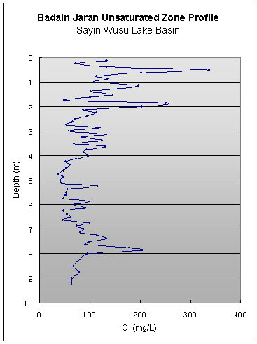
i) Unsaturated
zone profiles
The unsaturated
zone profile is shown in Fig. 1. Cl- concentrations
measured over the profile ranged from 36 mg/L to 336 mg/L, with the maximum
value within the upper 1 m and the lowest concentrations towards the
middle and bottom of the profile. A shallow peak in Cl- begins
to emerge at approximately 40 cm below surface and reaches its
maximum at 50 cm. This feature is common in arid unsaturated zone profiles
and can be found in most profiles in the Southwestern USA (Scanlon et al, 2003)
and Australia (Allison and Hughes, 1978). The peak likely represents Cl- that
has been accumulating since the last occurrence of ‘deep’ drainage, i.e. since
the last time moisture has been flushed below the zone of significant moisture
cycling due to evapotranspiration (zero flux plane). The peak is
more than an order of magnitude lower in concentration than some documented in
the USA, likely due in part to the lack of surface vegetation at this site.
Very high concentration peaks in arid unsaturated zones have been attributed to
zero or negative recharge throughout the Holocene, since their cumulative Cl- amounts
represent 12,000-16,000 years of accumulation (Walvoord et al, 2003).
A secondary peak
of approximately 250 mg/L is shown at a depth of 2 m. This may represent a
former near-surface peak which has been flushed down relatively recently.
Beginning at 3 m, the Cl- concentrations begin to steady, and
continue to fluctuate around a mean value of approximately 75 mg/L through
approximately 7.5 m. In general, signals corresponding to individual
recharge events tend to attenuate over time due to diffusion in the unsaturated
zone (Cook et al, 1992), and will approach a steady mean value over time. As
such, 75 mg/L is taken as the approximate mean Cl- input
signal over the period of record. Capillary fringe effects of the water table
on moisture contents begin at approximately 8 m. The smaller peak near a
depth of 8 m may be related to capillary effects. Alternatively, it
may represent either a large Cl- peak which has not yet
attenuated to due its high concentration, or possibly a longer-term variation
in the Cl- input signal in the past due to changing
climate conditions.
For the estimation
of inputs for recharge rate calculations, we employ the long-term rainfall
monitoring record from Zhongqanzi meteorological station
(approximately 30 km distance from profile site), which has a mean of 89
mm/yr for 1957–1999. However, because of the characteristically high spatial
and temporal variability in precipitation in this arid region, this mean
should be treated with a degree of caution. Long-term Cl-concentration
for rainfall was estimated at 1.5 mg/L from published results on a small number
of relatively intense storms by Ma and Edmunds (2006) and Hofmann (1999), as
well as two storms sampled during the 2005 field investigations. Confidence in
these data as representative of the true mean is boosted by the fact that 1)
the variability in Cl- concentrations across the sampled
events is quite low and 2) the vast majority of rainfall received in this area
results from a small number of heavy storms so that chemistry of storm events
reflect well the overall yearly total. However, further monitoring of rainfall
chemistry would serve to strengthen this analysis.
Using these
input terms, in combination with Cl- concentrations
between the shallow peaks and the capillary fringe, a long-term average
recharge rate is estimated to be 1.62 mm/yr. Applying the
cumulative Cl-equation for residence time, the surface peak
represents 20 years of accumulation, and the entire profile 430 years.
ii) Groundwater
chemistry and stable isotopes
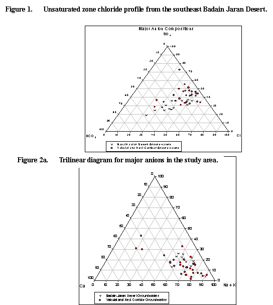
Summary trilinear diagrams
for major ions in groundwater are shown in Fig. 2. As reported by others
(Hofmann, 1999; Yang and Williams, 2003), the region’s shallow groundwater is
characterized by a high degree of variability, both with regards to TDS and
percent contribution of major constituents. In general, major anion
compositions of shallow groundwaters to the immediate south and
southwest of the desert are dominantly Cl- and SO42- in
type. This pattern transitions to no dominant type towards the desert interior,
concurrent with a trend of decreasing Cl- and TDS. Cation compositions
for the two areas are similar, but with rather high overall variability. Two of
the three apparent outliers represent artesian wells (<130 m depth) in
the vicinity of Youqi town, and one is a shallow farm well which may
be contaminated, as suggested by elevated nitrate concentrations in the sample.
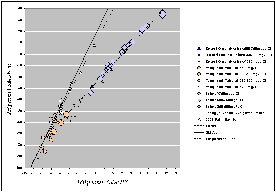
Stable isotope
results are summarized in a delta-plot relative to VSMOW in Fig. 3. The local
meteoric water line (LMWL) is regressed on all precipitation records from Zhangye Station
(r2=0.96), located approximately 250 km to the southwest
of the study area (GNIP/WMO, 2004), and weighted annual means for this data set
are plotted. Rainfall events sampled in 2005 fall closely along the Zhangye precipitation
line, supporting the assertion that this LMWL is valid for the study area.
Desert shallow groundwaters range from -5.4 to -2.0 δ18O
VSMOW, and in addition to lake waters, plot along an evaporation line with
slope of approximately 4.2 and LMWL intercept of approximately -12.5 δ18O
(r2=0.91). This slope is fairly typical of surface water evaporation
under low-moisture atmospheric conditions (Clark and Fritz, 1997). Along this
lineCl- concentrations tend to increase with increasing
isotopic enrichment, a second indicator of progressive evaporation.
Contrasting with
the desert groundwaters, shallow groundwaters to the south and
southwest tend to group along the LMWL, primarily between -7 and -11 δ18O
but as low as -12δ18O. Three exceptions to this general pattern are
shown lying along the evaporation line with high Cl- concentrations.
Discussion
The data reported
here add to a growing catalogue of tracer results for the Badain Jaran Desert
region (see for example Geyh et al, 1996; Hofmann, 1996; Ma et al,
2003; Yang and Williams, 2003; Chen et al, 2004; Ma and Edmunds, 2006; Yang,
2006). In general, they tend to reflect well the results of previous studies.
Regarding the profile-based estimation of direct recharge, the calculated
long-term average of 1.62 mm/yr is very similar to the results obtained by
Ma and Edmunds (2006) of 1.33 mm/yr, 1.26 mm/yr and 0.95 mm/yr.
With an annual rainfall rate of 90 mm/yr, direct recharge through the
dunes is close to 1% of annual rainfall, a common relationship for arid
regions. Note that these values are long-term averages, and that because of
extreme rainfall variability, it is likely that positive values for direct
recharge are not achieved in most years; instead occasional event-based
recharge is likely the pattern. The calculated Cl- accumulation
period of 20 years since the last significant recharge event is therefore
within reason.
When evaluating
the context for this result it is important to bear in mind that, since
estimates are inherently point-based, extrapolation of the estimates over a
large and complex landscape is problematic. However, since surficial materials
are quite uniform over the desert’s extent, a high degree of recharge
variability would be unexpected unless periodic runoff focuses in topographic
depressions, as has been well-documented in playas in some locations (Scanlon
and Goldsmith, 1997). While no evidence of runoff in the Badain Jaran is
apparent, additional profiles in topographic depressions are currently being
investigated as part of this project. Apart from this possibility, the
profile-based estimates can be considered as upper bounds for an
aerially-averaged direct recharge rate since i) these profiles were taken
at non-vegetated sites and ii) evaporation from shallow water tables may occur
in some interdune areas.
With potential
evaporation estimates of approximately 2600 mm/yr, mass-balance
considerations clearly indicate that direct recharge is not sufficient to
supply the desert lakes, and that additional recharge sources would be required
to do so. However, the only nearby major sources of water are down-gradient
from the desert interior (i.e. Guezi Hu Wetland and the Heihe River).
With exposed fissured rock surfaces, the Yabulai andLongshou mountain
ranges could possibly supply mountain-front or mountain-block recharge, but
under current climatic conditions this would not likely be able to sustain flow
volumes implied by the lakes. Remote-source recharge from the Qilian Mountains via
deep interbasin transfer has been suggested (Chen et al, 2004), but
is somewhat improbable from a hydrogeological perspective and is not
well supported by available data.
Stable isotope
results from the desert’s shallow groundwaters show a clear
distinction from groundwaters of surrounding locations to the south
and southwest, and also illustrate the intimate connection with the desert
lakes. The strong connection along the evaporation lines supports the
hypothesis that they are supplied entirely or primarily by shallow groundwater
(rather than a deeper formation), and are basically outcrops of the water table
of the shallow Quaternary sand aquifer. Further, the intercept of the
evaporation line with the LMWL (-12 δ18O) is significantly lighter
than mean modern rainfall at approximately -7 δ18O. Ma and Edmunds
(2006) argue that this depleted intercept with the LMWL is indicative of a palaeo-water
origin for the groundwaters, noting that -7 δ18O matches well
with expected rainfall values in this region during the late Pleistocene based
upon lake sediment palaeo-environmental records. The implication is that
the lake-feed groundwaters are not hydraulically related to areas to
the south and are not sourced from modern rainfall in the region.
If the above
interpretation is accurate, the most likely explanation for the ongoing supply
of fresh groundwater is that the desert’s shallow aquifer filled during more
humid climatic conditions in the past, and that flow is presently supported by
some combination of i) mountain-source recharge from the Yabulai and Longshou ranges
and ii) a diminishing water table which is out of equilibrium with
current climate and will continue to dry. Indeed, a range of evidence including
lake sediment records, palaeo-lake levels (Miscke et al, 2005) and
luminescence dating of dune sands (Yang and Williams 2003; Yang, 2006) indicate
that the late Pleistocene was significantly more humid in the region than at
present, and that the Holocene has been marked by strong climatic variability.
Radioisotope research is currently underway to test this palaeo-recharge
hypothesis by establishing a chronology for the desert groundwaters.
Well-defined
hydraulic head gradients from the Yabulai Mountains to the
northwest (roughly mirroring surface elevation and terminating in the Gurinai)
are apparent from lake and well levels, and strongly suggest an active flowpath from
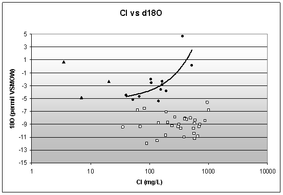
this mountain range feeding the desert. Geochemical results show that Cl- concentrations
and TDS generally decrease along this hypothesized flowpath, while SO42- and
HCO3- remain relatively constant. If the Yabulai range
was a prominent recharge source in the past, then the observed decrease of
conservative Cl- in the downgradient direction
may be consistent with the palaeo-recharge, since older waters (now
down-gradient) would be expected to be less affected by evaporation during
recharge than the younger, owing to the wetter climate. The Cl- trend
is mirrored by δ18O, with a strong
positive correlation between the two (Fig. 4). This is similar to results from
the Minqin Basin (100 km to the southeast), where the palaeowaters have
been confirmed by radiocarbon analyses (Edmunds et al, in press). Similar
scenarios of decreasing Cl- concentration in the downgradient direction
due to climate change have been documented elsewhere (see for example Edmunds
and Smedley (2000) on the East Midlands Sandstone Aquifer, UK).
In addition to
increased baseflow derived from mountain sources, it may be that
direct recharge within the desert has also played a more prominent role during
wetter and/or cooler climatic periods, since a higher ratio of precipitation to
evaporation would be experienced. The net effect would be that wetting fronts
would be able to pass below the zero flux plane more frequently,
though denser vegetation in these periods may have a moderating influence. A higher
direct recharge rate would also help to explain the high chemical variability
apparent in the shallow groundwaters.
It is recognized
that the scenario described above is not consistent with the conclusions of
some previous studies. Based on Mg2+ concentration, Hofmann
(1999) argues for two separate aquifers for the northern and southern areas of
the eastern lakes region, one supported by direct recharge and one by regional
flow from the Yabulai Mountains. He estimates that approximately 30
mm/yr direct recharge would be necessary to support the northern lakes. In view
of the global literature on arid zone recharge as well as the profile results
presented here, this value is not likely to be achieved under current climate
conditions. Also in contrast are the tritium results of Yang and Williams
(2003), which indicate a mean residence time of less than 100 years for the
shallow groundwaters. One possibility is that some of the waters that were
sampled had interacted with modern atmospheric tritium subsequent to recharge.
Many of the sampling locations were springs and shallow wells close to the
lakes, which may be subject to atmospheric interaction owing to the shallowness
of water tables in the interdune areas and nearby lakes. Finally,
while the proposition of Chen et al (2004) that snowmelt feeds the region
through deep faults needs to be tested further, the notion that groundwater
rises through hundreds of meters of low moisture-content sands to supply the
near-surface pore water runs counter to a great deal of physical vadose zone
research to date.
Conclusion
In this paper new
tracer data was presented to help establish a sound conceptual model for
groundwater recharge to the Badain Jaran shallow sand aquifer.
The results build on previously published data for the region, and were
generally in good agreement with the earlier data. It was shown that direct,
diffuse recharge through the Quaternary sands is low though nonzero, on the
order of 1 mm/yr. As approximately 1% of local rainfall this is consistent
with arid recharge studies elsewhere. Stable isotope ratios indicate that the
lakes are fed by shallow groundwater, which is not related to local
precipitation and most likely is palaeowater in origin, and therefore
non-renewable on human timescales. Major ion chemistry of the groundwaters is
consistent with this hypothesis, though high spatial variability complicates
interpretation.
The geographical
source(s) of the palaeowater cannot be identified at this time, but
possibilities include i) direct recharge under more humid conditions ii)
runoff from the Yabulai Mountains and iii) waters from theQilian Mountains/Tibetan
Plateau fed by interbasin flow through fault systems. Research
activities currently in progress including radioisotopes and groundwater
modeling will help to refine this conceptual model. A clear understanding of
the region’s hydrological systems will be valuable information for water
resources planning and environmental protection goals.
Acknowledgements
We are grateful to
Dr. George Darling (for stable isotopes) and Mr. Adam Young (ICP-AES under NERC
Grant OSS/301/0905) for analytical support for this project. Research funding
provided by Environmental Change Institute of Oxford University. Additional
thanks to Huang Tianming, Li Xianghu and Ding Zhenyu for
field and laboratory support.
References
[1] Allison, G.B. and
Hughes, M.W., 1978. The use of environmental tritium and chloride to estimate
total recharge to an unconfined aquifer. Australian Journal of Soil
Sciences, 16: 181-195.
[2] Chen, J.S., Li,
L., Wang, J.Y., Barry, D.A., Sheng, X. F., Gu, W.Z., Zhao, X.. and Chen,
L., 2004. Groundwater maintains dune landscape. Nature, 432: 459-460.
[3] Clark, I. and
Fritz, P., 1997. Environmental isotopes in hydrogeology. CRC Press/Lewis
Publishers, Boca Raton, 328 pp.
[4] Cook, P.G.,
Edmunds, W.M. and Gaye, C.B., 1992. Estimating paleorecharge and paleoclimate from
unsaturated zone profiles. Water Resources Research, 28: 2721-2731.
[5] Dong, G., Gao,
Q. & Zou, X., 1995. The climatic change during the last
Pleistocene in the Badain Jaran Desert. Chinese Science
Bulletin, 40: 1214-1218.
[6] Dong, Z., Wang, T.
and Wang, X., 2004. Geomorphology of the megadunes in the Badain Jaran Desert. Geomorphology,
60(1-2): 203.
[7] Edmunds, W.M., Ma,
J., Aeschbach-Hertig, W. & Darbyshire, F. (in press) Groundwater
recharge history and geochemical evolution in the Minqin Basin. Applied
Geochemistry.
[8] Edmunds, W.M. and Smedley,
P.L., 2000. Residence time indicators in groundwaters: The East Midlands
Triassic Sandstone aquifer. Applied Geochemistry, 15: 737-752.
[9] Geyh, M.A., Gu,
W. and Jäkel, D., 1996. Groundwater recharge study in the Gobi
Desert, China. Geowissenschaften, 7–8: 279–280.
[10] IAEA/WMO, 2004.
Global Network of Isotopes in Precipitation. The GNIP Database. Accessible at:
http://isohis.iaea.org.
[11] Hofmann, J., 1996.
Lakes in the SE part of Badain Jaran Shamo, their limnology and
geochemistry. Geowissenschaften, 14(7-8): 275-278.
[12] Hofmann J.,
1999. Geoökologische Untersuchungen der Gewässer im Südosten der Badain Jaran Wüste (Geo-ecological
investigations of the waters in the south-eastern Badain Jaran Desert).
[13] Berliner Geographische Abhandlungen, 64.
[14] Jackel, D., 1996.
The Badain Jaran Desert: its origin and development. Geowissenschaften,
7/8: 272-274.
[15] Ma, J., Ding, L., Jiawu,
Z., Edmunds, W.M. and Prudhomme, C., 2003. Groundwater recharge and
climatic change during the last 1000 years from unsaturated zone of SE Badain Jaran Desert. Chinese
Science Bulletin, 48(14): 1469-1474.
[16] Ma, J. and
Edmunds, W.M., 2006. Groundwater and lake evolution in the Badain Jaran desert
ecosystem, Inner Mongolia. Hydrogeology Journal, in press.
[17] Mischke, S., Demske,
D., Wunnemann, B. and Schudack, M., 2005. Groundwater
discharge to a Gobi desert lake during Mid and Late Holcene dry
periods. Palaeogeography, Palaeoclimatology, Palaeoecology,225: 157-172.
[18] Scanlon, B.R., Keese,
K., Reedy, R.C., Simunek, J., and Andraski, B.J., 2003. Variations in
flow and transport in thick desert vadose zones in response to paleoclimatic forcing
(0–90 kyr): field measurements, modeling, and uncertainties. Water
Resources Research, 39(7): 1179.
[19] Walvoord, M.A.,
Phillips, F.M., Tyler, S.W. and Hartsough, P.C., 2003. Deep arid system
hydrodynamics 2. Application to paleohydrologic reconstruction using vadose zone
profiles from the northern Mojave Desert. Water Resources Research,
38(12): 1291.
[20] Yan, M., Wang, S.,
Li, B. and Dong, G., 2001. Formation and growth of high megadunes in Badain Jaran Desert. Acta Geographica Sinica,
56: 83-91.
[21] Yang, X.,
2006. Chemistry and late Quaternary evolution of ground and surface waters in
the area of Yabulai Mountains, western Inner
Mongolia, China. Catena, 66(1-2): 135-144.
[22] Yang, X. and
Williams, M.A.J., 2003. The ion chemistry of lakes and late Holocene
desiccation in the Badain Jaran Desert, Inner Mongolia, China. Catena,
51(1): 45-60.
Figures
|
|
|||
|
|
||
|
|
||
|