


Achievements
STUDY ON ECOLOGICAL WATER DEMAND IN KUITUN RIVER BASIN, XINJIANG
Mu Minxia ,Wang Wenke ,Du Dong ,Zhao Shunyang ,Yang Lijun
School of Environmental Science and
Engineering, Chang’an University,Xi’an 710054,
China
Abstract:The Kuitun river
basin is situated in Xinjiang in the arid regions of northwest of
China With the increase of population and the development of economy, the
national-economy water demand and the ecological water demand has become the
principal contradictions of development and utilization of water resources of
basin and ecological environmental protection. So, in order to realize the
sustainable utilization of water resources in the Kuitun river basin and
sustainable development of national economy, the ecological water demand should
be studied immediately. In this paper, with the purpose of coordinated growth
between the social economy and the eco-environment of this area, it analyzed
the main eco-environment problems of the Kuitun River basin. At the
basis of conception and classify of ecology water demand in arid areas, it
imposed restrictions on ecology water demand of Kuitun River basin.
On the premise of this, it proceeded from the current situation of this basin’s
eco-environment and the future demand, using different computing technologies
and calculating its ecology water demand. It provides the scientific basis for
basin water resources rational distribution and constructions of
eco-environment.
The result showed
that the ecological water demand in the Kuitun River basin reached 4.39*108m3 ,which
occupies 24.6% of the whole water resource about 17.83*108m3,
and 26.0% of the whole runoff about 16.79*108m3. In which
the nature oasis ecological water demand reached 2.59*108m3,occupied 59% of the ecological water demand;
the artificial oasis ecological water demand reached 1.8*108m3,occupied 41% of ecological water demand.
Keyword: eco-environment
problems; ecological areas; calculate method; ecological water demand; the Kuitun River
basin; Xinjiang
1 Brief Introduction of the Kuitun River Basin
The study area is
located at the northern foot of Tianshan Mountain, the southwest edge
of Zhungaer basin. The landform is high at the south and low at the north, with
high mountains, hills, alluvial and diluvial plain, desert and other various
topographies. The climate has a typical continent arid climate feature, and the
irrigation for agricultural production is by artificial canal or takes out
underground water. According to the statistical information from meteorological
station of Kuitun, Wusu and Chepaizi the long-term annual average temperature
is 7.0℃, average yearly
precipitation only 160mm, average yearly evaporation 1810 mm. The
winter is severe cold and long and the summer is hot and short, the spring and
the autumn is changed greatly, with long sunshine and big temperature
difference.
All rivers in the
study area belong to Aibi lake water system, originated from Tianshan Mountains flowing
from south to north leading to the Aibi Lake, which is supplied
mainly by snowmelt and rainfall fromTianshan Mountains. There are three
major rivers in the study area. They are Kuitun river, Sikeshu river and Gurtu River. The annual average flow volume
respectively is 644 million m3 , 289 million m3 and
338 million m3. These rivers contain water throughout the year,
while most of the water volume is intercepted upstream for agriculture
irrigation.
The remaining flow
tends to be minimal, sometimes disappearing completely. The total trunk stream
is 360km in length, covers a total area of 2.54*104km2.
2 Main Ecological
Environmental Problems in the Study Area
With the
population growth and rapid economic development in the study area and
increasing trend of development and utilization of water resources, the
ecological environmental problems are becoming increasingly serious and mainly
manifested in the following aspects:
2.1 Dry-up of
watercourses at the lower reaches
With the
population growth and large-scale exploitation of water and soil, a good many
projects of piloting, storing, and delivering have been built along Kuitun
River, Sikeshu River and Guertu River, from 1950s to 1970s. By 2003, the
population in the study area had reached 560,000, up by nearly 10
times over that in the 1950s; irrigation area 2.75 million mu, the second
largest oasis formed at the north foot of Tianshan Mountain after the 1950s; 8
piloting hinges, with the designed piloting capacity being 380 m3/s
and annual piloting volume being 11.27*108m3; 14 plain
reservoirs, with the designed storage capacity being 3.22*108m3; 666kmtrunk
channels, of which 377km have been processed with anti-seepage
materials, with anti-seepage rate being 57%; and 5,407km drainge
canals. Because of the sharp rise of population in the drainage area and the
continuous increase of piloting volume at the upper reaches, the watercourses
at the lower reaches have been dried up.
2.2 Deterioration of
natural vegetation
Due to the water
piloting in the upper reaches, water flowing into Ganjiahu at the lower reaches
of Kuitun River, Sikeshu River and Guertu River began
to decline, which resulted in the drop of underground water table and the
reduction of natural vegetation in the area. Before the 1950s, the haloxylon
ammodendron forest around Aibi Lake covered a total area 6.67*104hm2,
with the coverage being 60% to 70%; populus euphratica forest 3.78*104hm2,
with the coverage of medicinal plants being 70%, such as radix liquiritiae
and herba cistanches; reed 4.6*104hm2, with the coverage
being above 80%; and grass farm 1.0*104hm2, along with
desert grass land of 2.67*104hm2 and desert
secondary forest of 13.67*104hm2. With the growth of
population and the increase of water development for agriculture, the water
volume in the lake has declined, water table dropped, but the cultivation of
farmland lifted and animal grazing area expanded, all of which led to the
serious damages to forests of haloxylon ammodendron, populus euphratica, and
reed. According to statistics, the total area of haloxylon ammodendron and
populus euphratica forests dropped to 3*104hm2 and
reed to 0.26*104hm2 in 1990. The degeneration
of grassy marshland was extremely serious.
2.3 Lake shrinkage
The reasons for
the shrinkage of the water area of Aibi Lake are multifold,
including structure movement, climate and water resources change, and
artificial factor. In the past, the study area of Kuitun Riveraccounted
for 44% of the surface water amount entering the Aibi Lake. However, Kuitun River has
been dried up at the lower reaches since the 1970s, and there is no surface
water flowing into Aibi Lake in ordinary years. The changes of
water area of Aibi Lake are detailed as chart 1:
Chart 1 reveals
that the water area of Aibi Lake is showing a trend of gradual
shrinkage, down by half from the 1950s to the mid 1980s, with the annual
average reduction being 15km2; maintaining around 500~600 km2 after the mid
1980s in spite of slight fluctuations.
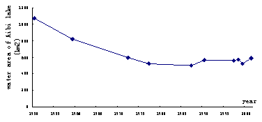
Fig.1 Variation of water areas of Aibi Lake from 1950 to 2003
2.4 Soil
salinization aggravates
Since the 1950s, people began to reclaim wastelands, channel water and construction of plain reservoirs along the two banks of rivers in a big way. A great deal of surface water drawn into irrational irrigation had led the obvious change of hydro geological condition of the irrigation area. The underground water table of irrigation region rises at large. The hydro geological mapping in 2003 shows that the underground water table in about 60% of the whole irrigation region is higher than 2m, the agricultural production is difficult to get rid of the obsession of salinization. The intense capillarity and evaporation resulted in the salinization of soil in the irrigation areas, and the cultivated land was hence wasted again, houses toppled down, and residents removed. The point can also be illustrated with remote-sensing interpretation results in different periods, with details seen Table 1.
Table 1 Statistic of
salina and wetland areas in differ period of
the Kuitun River basin
|
Year |
Areas of salina(km2) |
Areas of wetland(km2) |
|
1970 |
37.2 |
135.3 |
|
1990 |
1245.4 |
180.2 |
|
2000 |
785.7 |
32.4 |
Table 1 reveals that the areas of saline-alkali land and swampland in
the study area had increased by 33 times and 1.3 times from 1970 to 1990
separately, and the area of saline-alkali land, in particular,
increased sharply; because of the construction of drainge canals, the areas of
saline-alkali land and swampland had declined to different degrees from 1990 to
2000.
2.5 Aggravation of
land desertification
Because of the continuous interception of water flows at the upper reaches of Kuitun River, Guertu River and Sikeshu River and the anarchic mining of gold diggers in the past forty years, the water source of forest area of Ganjiahu could not be suppllied efficiently, and most of vegetables began to wither up. Meanwhile, the perennial wind at the mouth of Ala Mountain makes the sand dune between Guertu River and Ganjiahu move eastward at the speed of 12 meters every year. A green barrier of over tens of millions mu has been reduced to 740*104 mu. The moving of desert deteriorated the ecological environment at the lower reaches of Kuitun River year by year, and the land desertification was aggravated.
In allusion to
ecological environment problems in the study area of Kuitun River,
water becomes the most active and sensitive factor restricting the sustainable
development of the social economy and the protection of the ecological
environment on the premise that the aggregate water volume is not changed.
Therefore, the paper will, on the basis of the concept and categorization of
ecological water demand in the arid zone, analyze and calculate the ecological
water demand in the study area of Kuitun River with different
methods.
3 Concept and
Categorization of Ecological Water Demand
3.1 Concept of
ecological water demand
There are a
variety of definitions and studying methods of ecological water demand, but not
a single one is adopted unanimously. Ecological water demand in a broad sense
refers to the water needed in maintaining the water balance of the earth
biological, geographical, and ecological systems, including water-heat balance,
water-sand balance, and water-salt balance etc. [1]. In a
narrow sense, it refers to the water consumed in the stabilization of the
ecosystem, the protection of natural ecology, and the construction of
artificial ecology[2]. In terms of the definition, the current study
result deems that the ecological water demand in arid areas refers to the
minimum volume of water needed in maintaining the ordinary subsistence and
multiplication of natural oasis, ecological systems in watercourses (bank
vegetation, valley forest, and water quality), and protection vegetation
systems in artificial oasis in the drainage area in a certain period of time.
Hence, we can conclude that ecological water demand is closely related to
ecological types: water demand varies from ecological type to ecological type.
Based on this, the understanding of the ecological water demand in the drainage
area of Kuitun River is: under the condition of sharing water resource by production,
living, and ecology, ecological water demand needed in maintaining the existing
ecological system should give priority to the guarantee of the groundwater
volume of Aybi Lake and the minimum water resource needed in maintaining the
ordinary subsistence and multiplication of protection vegetation systems in the
artificial oasis. Meanwhile, the haloxylon ammodendron forest will not
degenerate in the natural protection areas of Hena Forest, Hegu Forest,
and Ganjiahu at the lower reaches of Kuitun River. This indicates
that the priority should be given to ecological environment in the
configuration of water resource in the drainage area of Kuitun River.
The ecological water demand will not continue to decline in the future, and
regions of partial ecological environmental worsening should increase somewhat.
Only in this way can the coordinated development of regional economy and
ecological environment be ensured.
3.2 Categorization
of ecological water demand
The water demand
in the drainage area of Kuitun River falls into two categories,
namely national economical water demand and ecological water demand. This paper
mainly dwells on the latter.
Ecological water
demand includes artificial ecological water demand and natural ecological water
demand. The former refers to the water needed in the ecosystem under the direct
or indirect effect of people; the latter refers to the water needed in the
ecosystem basically without the artificial effect. In terms of the actual
situation of Kuitun River, artificial ecological water demand includes ① shelterbelt, ② irrigation grass farm, and ③ urban greening etc. Natural ecological
water demand includes ① desert river bank forest, ② river valley forest, ③ low-land grassy marshland, ④ desert vegetation, and ⑤ river and lake etc. In the light of the
above analysis, the ecological water demand in the drainage area of Kuitun River can
be concluded as Table 2.
Table 2 Classification of water
demand of ecological system in Kuitun River basin
|
artificial ecological water
demand |
Natural ecological water
demand |
||||||
|
shelterbelt |
irrigation grass farm |
urban greening etc. |
desert river bank forest |
river valley forest |
low-land grassy marshland |
desert vegetation |
river and lake etc. |
4 Analysis of
Ecological Water Demand
In terms of
sources, ecological water demand in Table 2 can be divided into three
categories: ① ecological
water demand of artificial oasis, supplied by surface water in the way of
irrigation; ② ecological
water demand of natural oasis, supplied by groundwater in the way of phreatic
groundwater evaporation; and ③ ecological water demand of rivers and lakes,
supplied by both surface water and groundwater.
Since the
components of the first category of ecological water demand have the same
requirements on their growth as those on crops under their shield, the volume
can be obtained through the direct calculation method, namely that component
areas multiply irrigation ration.
With regard to the second category of ecological water demand, it is mainly for the mesoxerophytes and mesophyte, which are distributed in bottomland, low-step land, lakeside, and swale with high underground water table. The vegetables rely on groundwater to maintain their lives, and the main form is the transpiration in the growth period. So the water volume can be determined through transpiration method. At present, there are a variety of ways of calculating vegetation transpiration volume, which are measurement transpiration method, Aweiyangnuo formula, Shen Lichang formula, Penman formula, SPAC model, ecological water demand quota method, and ecological water demand method based on remote sensing and GIS. In the light of the actual situation of Kuitun River, this paper calculates the evaporation volume of phreatic groundwater with ecological water demand quota method, phreatic groundwater transpiration method, Aweiyangnuo formula, and Shen Lichang formula separately, and then obtains the ecological water demand on the basis of calculation results.
The last category
is the ecological water demand of lakes and rivers. Since Kuitun River has
dried up at the lower reaches in the 1970s, and there were no surface water
flowing into the lake, the water of Aibi Lakeis mainly supplied by Boertala River and Jing River.
Therefore, in light of Criteria on Planning Environment Evaluation of
River Basin, Planning of Boertala River Basin and Jinghe River
Basin, and Planning of Kuitun River Basin, apt the lake water
area should be established as the goal to attain so as to ensure the ecological
environment of Aibi Lake. In the past twenty years (since 1985), the
water area of Aybi Lake has been maintained around 500~600km2. Based on this and in
consideration of the status of the environment around the lake and the water
demand of the regional economic development, the volume of Kuitun Rivergroundwater
flowing into Aibi Lake should be no less than 0.42*108m3 every
year in the light of Investigation and Evaluation on Groundwater
Resource and Environment Problem in Zhungaer Basin.
4.1 Artificial
ecological water demand
Based on the land
utilization of the drainage area of Kuitun River and in the light of
remote-sensing data, we first gather the statistics of distribution areas of
artificial shelter forest, irrigation grassland, and urban greening in each
administrative area separately, and then calculate the concrete water demand in
terms of farm irrigation quota of each irrigation area in the drainage area of
Kuitun River and the coefficient method of irrigation water comprehensive
utilization, with result detailed in Table 3.
4.2 Natural
ecological water demand
Calculate natural
ecological water demand with different methods.
4.1.1 Quota method
The ecological water demand quota of vegetation is related not only to natural factors such as climate condition and soil substance, but to group type and vegetation category as well. Directed to different ecological water demand types, typical species are selected as the reference species, and their ecological water demand quotas are taken as the quota for the type. The paper, on the basis of the evapotranspiration study result of different tree species in natural oasis of arid zones and in the light of the distribution area of natural oasis vegetation in the drainage area of Kuitun River, the paper calculates the ecological water demand volume with quota method, with result detailed in Table 4.
Table 3 Result of water demand by artificial oasis eco-system in Kuitun River basin Subarea Shelter forest water demand(104m3) irrigation grassland water demand(104m3) urban greening water demand(104m3) Total of water demand(104m3) Nongqishi 9702 552 92 10346 Wuau City 5013 322 92 5427 Kuitun City 1455 46 552 2053 Dushanzi District 184 184 Total 16170 920 920 18010
Table 4 Results of
eco-demand water of natural oasis by quota calculated
|
Types |
Evaporation value(m3/hm2) |
Rainfall (m3/hm2) |
Quota of water demand (m3/hm2) |
Areas(km2) |
Total of water demand(104m3) |
|
Desert river bank forest(Huyang) |
4846 |
1441 |
3405 |
135 |
4597 |
|
River valley forest (Poplar) |
6691 |
1441 |
5250 |
290 |
15225 |
|
Desert
vegetation(haloxylon
ammodendron forest) |
1095 |
1441 |
|
|
|
|
Low-land grassy marshland |
|
1441 |
1470 |
34 |
500 |
|
Total of water demand |
|
|
|
459 |
20322 |
Table 4 reveals that the ecological water demand of natural oasis calculated with ecological water demand quota method is 2.03*108m3, of which the volume of river valley forests is 1.52*108m3, accounting for 75% of the total. The ecological water demand of desert forests is not included in the table, because desert forests in the study area are mainly distributed in the natural protection area of Ganjiahu. The main species include haloxylon ammodendron, white haloxylon ammodendron, red lauan, and reaumuria soongonica, of which haloxylon ammodendron and white haloxylon ammodendron take the predominance. In the light of studies, the ecological water demand quota of natural haloxylon ammodendron forest is 1,095 m3/hm2 when the coverage is 30%. But the annual average rainfall in the area of Ganjiahu is 144.1mm or 1441 m3/hm2, above the quota. This indicates that haloxylon ammodendron forest can relies on rainfall to maintain its life. Therefore, the ecological water demand of desert haloxylon ammodendron forest is not calculated.
4.2.2 Phreatic
water transpiration method
To multiply the
area of a vegetation type at a given depth of groundwater buried by the
evaporation at the phreatic water level and vegetation coefficient:

In the formula:  is the
ecological water demand of vegetation typei;
is the
ecological water demand of vegetation typei;  is the
distribution area of vegetation type i;
is the
distribution area of vegetation type i;  is the
phreatic water evaporation of vegetation type i at a given depth of groundwater buried
is the
phreatic water evaporation of vegetation type i at a given depth of groundwater buried  (m); K is the vegetation coefficient.
Calculation formula of phreatic water evaporation:
 n=2.15±0.025
In the formula:  is the
extreme critical depth of phreatic water evaporation (m);
is the
extreme critical depth of phreatic water evaporation (m);  is the water
surface evaporation of a 20m2 evaporation tank (m); and
is the water
surface evaporation of a 20m2 evaporation tank (m); and  is the depth
of groundwater buried (m).
is the depth
of groundwater buried (m).
Research shows
that the extreme critical depth of phreatic water evaporation in the study area
is 5m. The experimental data of Hadi Slope in the valley of Toutun River
also at the north foot of Tianshan Mountain are adopted as the values of and  . The calculation
results are detailed in Table 5.
. The calculation
results are detailed in Table 5.
Table
5 Result of eco-demand water of natural oasis in different
vegetation types
|
Types |
The range of depth of
groundwater buried (m) |
h (m) |
areas(km2) |
vegetation coefficient k |
water demand(104m3) |
|
Desert river bank forest |
2~3 |
2.5 |
135 |
1.47 |
4112 |
|
River valley forest |
1~3 |
2.0 |
290 |
1.62 |
15266 |
|
Low-land grassy marshland |
1~2 |
1.5 |
34 |
1.77 |
3370 |
|
Total of water demand(104m3) |
|
|
459 |
|
22748 |
4.2.3 Shen Licheng formula and Aweiyangnuo formula
4.2.3.1 Shen
Licheng formula:

In the formula:  is the
phreatic water evaporation at a depth of phreatic water buried h (m);
is the
phreatic water evaporation at a depth of phreatic water buried h (m);  is the
surface evaporation (m).
is the
surface evaporation (m).
4.2.3.2
Aweiyangnuo formula

In the formula:  is the
phreatic water evaporation at the phreatic water buried depth h (m);
is the
phreatic water evaporation at the phreatic water buried depth h (m);  is the
surface evaporation (m);
is the
surface evaporation (m);  is the
extreme critical depth of phreatic water evaporation (m).
is the
extreme critical depth of phreatic water evaporation (m).
Ecological water
demand W, the water volume needed in maintaining a given area of vegetation,
can be expressed with the product of the area S of natural vegetation to be
protected and the evapotranspiration E of unit area vegetation (nearly equal to
the evaporation of phreatic groundwater), namely . Please see Table
6 for details.
. Please see Table
6 for details.
Table 6 Result of
eco-demand water of natural oasis by different method (104m3)
|
depth of groundwater buried(m) |
areas(km2) |
Aweiyangnuo formula |
Shenlichang formula |
|
1~3 |
1014 |
21402 |
18830 |
|
3~5 |
1462 |
769 |
2351.5 |
|
Total |
|
22171 |
21181.5 |
It can be known
from the above calculations that the ecological water demand in the drainage
area of Kuitun River is 4.39*108m3.
5 Requirements on
Ecological Water Demand in the valley project of Kuitun river
Practices show
that the economic development in arid zones is actually on the basis of
damaging natural vegetation growth and consuming water resource; the
consideration of ecological water demand in the planning and management of
drainage areas and taking it as the water-supply subject indicate the start of
the rational understanding of ecology, and the ultimate purpose is to maintain
the coordinated development between the sustainable growth of regional economy
and the protection of ecological environment.
The ecological
water demand index was firstly put forward in the valley project of Kuitun River started
in 2001, and ecological water demand was taken as the water-supply object in
the supply-demand balance of water resource in the area. The annual average
runoff of the three main rivers in the drainage area of Kuitun River is
12.19*108m3, which has been
consumed up in irrigation areas. The following principles are defined in the
drainage planning: in ordinary years, the ecological water demand of natural
vegetation at the lower reaches should not be less than 20% of the runoff, and
water is mainly delivered to watercourses at the lower reaches in flood season.
When external water flows into the drainage area, the ecological water demand
of natural vegetation at the lower reaches should not be less than 35% of the
runoff. Hence, it can be calculated that the ecological water demand of natural
vegetation in the lower reaches should be 2.44*108m3 at least in
ordinary years.
6 Result &
Discussion
(1) The ecological
water demand in the drainage area of Kuitun River calculated with different
methods is 4.39*108m3.
(2) It can be
known from the calculation result that the natural ecological water demand in
the drainage area of Kuitun River calculated with different methods is around
2.59*108m3, and the
ecological water demand of natural vegetation in the lower reaches of the
drainage area determined in the planning should not be less than 2.44*108m3. So the natural
ecological water demand calculated in the paper can be taken as the reference
and basis for the optimized configuration of water resource.
(3) It can be
known from the calculation result that the ecological water demand in the drainage
area of Kuitun River is 4.39*108m3, of which the
natural ecological water demand is around 2.59*108m3, accounting for
59%, and artificial ecological water demand is 1.8*108m3, accounting for
41%. In the light of the actual situation of the drainage area of Kuitun River,
the natural oases are all at the outside of artificial oasis, so they are the
natural barrier of artificial oasis and the fundamental guarantee for the
sustainable development of artificial oasis. And water is the most active and
sensitive factor in the environment. Under the condition that the overall
quantity of water resource is unchanged, natural oasis and artificial oasis are
competing for water consumption.
(4) In terms of
the internal artificial oasis and natural oasis, shelter forests require the
biggest water demand, being 1.62*108m3, accounting for
90% of the total ecological water demand of artificial oasis. And irrigation
grassland and urban greening objectively play a positive role in the
maintenance and improvement of the ecological environment of artificial oasis,
but the water demand is rather small, only 10% of the total. In the ecological
water demand of natural oasis, river valley forests require the biggest water
demand, being 1.55*108m3. Since they are at the outside of oasis and of great
importance to the stabilization of oasis production and ecological environment,
their ecological water demand is the biggest.
(5) In terms of
calculation method, the phreatic water evapotranspiration of each climate zone,
each depth area, each forest, and each grassland should be calculated
separately in theory when indirect ascertaining method is applied. Only results
calculated in this way are perfectly accurate. But the method is infeasible
because of the shortage of measurement data. In the case, this paper estimates
the ecological water demand in terms of different forests, grasslands, the most
important species, vegetation, and depth. In the light of the calculation
result, indirect ascertaining model may reflect the water demand of each
ecological water demand type at length, but it needs too many parameters, and
the parameters have to be modified for different areas. Therefore, although it
is allowed to calculate ecological water demand in arid zones through direct
estimation method and indirect ascertaining model, further studies are still
needed.
References
[1] Su Xiaoling, Kang Shaozhong. Concept of Ecological Water Requirement
and its Estimation Method. Advances in Water Science. 2003,14(6):740~744.
[2] Wang Yumin, Zhou Xiaode. Research Development of Ecological Water
Demand for Watershed. Journal of Soil and Water Conservation. 2002,16(6):142~144.
[3] Wang genxu, Cheng Guodong. Water Demand of Eco-system and Estimate
Method in Arid Inland River Basins. Journal of Desert Research. 2002,22(2).
[4] Wang Ranghui, Lu Xinmin et al. Patterns and Characteristics of
Ecological Water Demand in West Arid Zone of China—A case study of green
corridor in the lower reaches of Tarim River. Chinese Journal of Applied
Ecology. Apr. 2003, 14(4):520~524.
[5] Huang Tianming, Wang Xiongshi, Shi Peize. Estimating of Water Demand
of Ecosystem and Rebuilding Ecosystem in Arid Areas. Journal of Arid Land
Resources and Environment. 2004, Nov. 18(8) :43~47
[6] Zhang Li, Deng Zengchuan, Zhao Bin. Method for
Estimating Ecological Water Requirement of Natural Vegetation in Arid Area.
Advances in Water Science. Nov. 2003, 14(6):745~748.