Achievements
THE EVOLUTION OF GROUNDWATER ENVIRONMENT AND ITS HYDROGEOLOGIC MEANINGS IN FEICHENG COLLIERY
Yueming Qi1,Yuxiang Jiang2,Lanhe
Yang1,Yongguo Yang1
(1.China
University of Mining and Technology, Xuzhou,Jiangsu,221008,China;
2. Feicheng Mining
Group Co. L td, Taian,Shangdong,271608 ,
Abstract:Feicheng colliery is noted for
its severely-threatened groundwater in
Keywords: groundwater
environment, evolution,hydrogeology, renovate rate, Feicheng colliery
1 Intruduction
Feicheng colliery locates in Feicheng city,
2 Hydrogeological Conditions
2.1
Natural recharge, runoff and drain conditions before digging
Atmospheric precipitation is prime recharge source of groundwater.
In the natural conditions before 1960, the groundwater flowed from the
northeast to west or southwest, the southwest in the basin was the drain port of the surface water and groundwater.
2.2 Stratums
The strikes of the stratums are east-northeast and the dip angles
are 6˚〜18˚, toward north. From the top down (or from new to old), the
stratums are Quaternary System, Permian System , Carboniferous
System, Ordovician System,
Cambria System and the former Sinian Period.
3
Evolution of groundwater environment
Water environment, viz. the spatio-temporal conditions around water bodies. Usually people point it
to water quality, but hydrodynamical conditions
also have important influence on the development of water quality. Thus,
exactly to say, the water environment should refer to physical, chemical,
biological conditions and the transformation during the formation, movement,
change of nature water.
So the groundwater environment not only includes groundwater
chemical environment, but also groundwater dynamical conditions. The evolution
of groundwater environment is slow in natural conditions, only when big changes
of external conditions occur, which may result in groundwater system changing
greatly in a short term. Therefore, the authors will make a systematic
exposition for spatio-temporal characteristics of groundwater environment
from the hydrodynamic conditions (mainly water levels) and the hydrochemical conditions (water quality).
3.1 Trends of the
water level fluctuations
Water levels are important indicator of groundwater dynamic
conditions, especially for different aquifers, the differences of water levels
show the way and degree of their hydraulic contact.
Without human influence, the evolution of groundwater dynamic
environment is very slow. Among other factors, such as precipitation, not only
affects the amount of groundwater safety exploitation, but also directly
determines the supply amount of groundwater. Thus, the evolution of groundwater
dynamic environment is resulted from many factors, Such as hydrogeological conditions, the intensity of human
activities, weather and hydrologic factors [1],
etc. Before 1960, the groundwater flow field was kept in the natural state in
the colliery, the movement of groundwater was mainly horizontal, and its vertical movement was unobvious,
hydraulic contact between the aquifers was weak, for there were some clay seams
and thick sandrock among them, which obstruct their
contact, so the water levels in aquifers were different ,water pressure and
types of water quality were also different from each other.
With coal-digging, the water levels of some aquifers descended and
came into being descended water cones[2]. Up to now, scores of water
cones have been engendered in different dimensions in the area, and the
directions of groundwater movement have been changed greatly, groundwater could
not flow freely out from basin, but was extracted to the ground by human
actions (such as mine drainage and water supply,etc.), thus the natural
open groundwater system was evolved into independent relatively water cycle
system in present.
Among main aquifers, due to the lack of recharge resources, a
majority of hydrogeologic blocks in 4th limestone have not
abundant groundwater except few blocks whose geological structures are complex,
so the water level has been descended rapidly and 4th limestone was almost
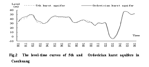
drained emptily in 1983. Whereas, trends of water levels in 5th limestone and
Ordovician limestone have been descended gently until 2003, subsequently, again
ascending and its level got +
In space scale(Magnitude is meter), groundwater quality shows obvious
differences with the variation of space positions .
In vertical direction, take Baizhuang well
field as an example, the following table(table 1) shows the water quality in aquifers and
surface water.

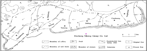
Fig. 1 The flow field of groundwater in Feicheng Colliery


Table 1 Thecontents of main compositions in
|
Items |
K+ |
Na+ |
Ca2+ |
Mg2+ |
NH4+ |
Cl- |
SO42- |
HCO3- |
F- |
NO2- |
NO3 |
Hardness |
TDS |
|
Surface
water |
1.7 |
85.0 |
122.1 |
28.1 |
0.0 |
34.0 |
273.6 |
326.8 |
0.5 |
0.0 |
19.3 |
420.5 |
739.2 |
|
Quaternary
System |
0.3 |
22.3 |
164.7 |
23.9 |
0.0 |
65.0 |
133.3 |
325.4 |
0.2 |
0.0 |
94.9 |
509.9 |
680.9 |
|
Minewater |
3.1 |
137.3 |
47.6 |
18.7 |
0.0 |
36.9 |
172.8 |
388.7 |
0.7 |
<0.004 |
14.1 |
195.8 |
647.8 |
|
4th
limestone |
1.4 |
185.0 |
13.7 |
5.4 |
0.6 |
24.0 |
35.8 |
422.5 |
1.6 |
<0.004 |
<0.4 |
56.5 |
501.0 |
|
5th
limestone |
1.6 |
25.3 |
77.9 |
24.5 |
0.0 |
27.0 |
60.6 |
304.2 |
0.4 |
0.2 |
6.5 |
295.3 |
386.7 |
|
Ordovician |
0.8 |
15.2 |
82.9 |
24.3 |
0.0 |
30.0 |
49.5 |
284.4 |
0.4 |
0.0 |
16.6 |
307 |
378.2 |
Table 2 Thetypes of water quality in 4th limestone aquifer
|
Well
fields |
Yangzhuang |
Caozhuang |
Dafeng |
Taoyang |
Baizhuang |
Guojiazhuang |
Chazhuang |
|
Types
of water quality |
HCO3-Na |
SO4-Na |
HCO3Cl-Ca |
HCO3-Na |
HCO3Cl-Na |
HCO3-Ca |
HCO3-Na |
Table 3 The change of key ions in three main aquifers
|
Aquifers |
Date |
K++Na+ |
Ca2+ |
Mg2+ |
Cl- |
SO42- |
HCO3- |
|
4th limestone |
1963.9 |
284.74 |
3.21 |
1.09 |
48.56 |
4.94 |
577.2 |
|
1993.9 |
244.79 |
5.69 |
0.72 |
34.74 |
5.35 |
533.79 |
|
|
2004.6 |
186.4 |
13.69 |
5.43 |
23.97 |
25.78 |
422.5 |
|
|
5th limestone |
1964.4 |
74.06 |
42.1 |
18.18 |
32.62 |
22.22 |
331.95 |
|
1989.4 |
14.72 |
74.45 |
17.53 |
16.08 |
33.65 |
283.22 |
|
|
1993.8 |
19.32 |
74.38 |
22.11 |
17.03 |
45.89 |
299.72 |
|
|
2004.6 |
26.95 |
77.89 |
24.47 |
27.03 |
60.54 |
304.24 |
|
|
ordovician limestone |
1963.9 |
29.14 |
64.61 |
25.86 |
21.81 |
72.84 |
273.85 |
|
1993.8 |
8.51 |
76.61 |
19.83 |
15.85 |
31.28 |
287.86 |
|
|
2004.6 |
15.99 |
82.94 |
24.25 |
29.99 |
49.53 |
284.41 |
Table 4 The way and characteristics of hydraulic
contact
|
Items Types
of contact |
Way of contact |
Hydrochemistry |
Water level |
Change route |
Extents of contact |
|
Horizontal direct contact |
horizontal flow |
horizontal change commonly |
common change from high to low |
long |
common |
|
Horizontal indirect contact |
horizontal slow flow by
water-hindering fault |
horizontal change obviously |
slow change from high to low |
short |
slow |
|
Vertical indirect contact |
leakage |
vertical change obviously |
level regime is different |
short |
weak |
|
Vertical direct contact |
conduct-water faults |
vertical change unobviously |
level regime is similar |
long |
intense |
From the table, we can find that the hydrochemical characteristics are different between the aquifers.
Since commonly there is a stable clay terrane under Quaternary System pore water aquifer that make it almost
no hydraulic contact with Carboniferous-Permian coal system aquifers and Cambria- OrdovicianSystem karst aquifers, so Quaternary System pore water aquifer has its obvious
characteristics that the contents of K+, F+ is low, while NO3-,
Ca2+ is high, that
agrees with the result of Zheng Ma’s research[3].
Ordovician karst fissure
water is the main type of groundwater in Feicheng basin,
due to long-term massive drainage (such as mine drainage and water supply
exploitation), make it in a good oxidative environment, in which nitrogen
element is turned into saltpetre state
(NO3-) or subsaltpetre state
(NO2-), the ammonia ion (NH4+)
content is low or even little.
Opposite to the Ordovician limestone karst water, in the early days, 4th
limestone karst water was in the deoxidization
conditions, although its eventual recharge was also coming from Ordovician karst water, but the contents of NO3- and NO2- are very low, so is its hardness.
While the contents of ammonia ions (NH4+), potassium-natrium ions
(K+, Na+,) and fluorine ion (F-) are all high.
The water quality of 5th limestone karst water is similar to that of Ordovician
limestone and the differences between them is less.
According to the analyzing of mine water quality, the contents of
some ions such as SO42-,F- and hardness are all high, their main
recharge sources come from 4th limestone and Ordovician limestone aquifers, so
mine water is a mixed water. When it is mainly recharged by 4th limestone karst water, the contents of hardness and
nitrogen are lower; when mainly recharged by Ordovician limestone karst water, they are higher. At the water
warehouse of -150 and -230 m level in Baizhuang well
field, where the compositions of mine water are similar with that in Ordovician
limestone karst water ,it shows that there is close
contact between them and should be paid great attention to.
Besides the vertical differences of water quality in aquifers,
some differences are also shown in plane. The same aquifer, when it meet
different geological structures or same structure while in different positions,
viz. the geological conditions are different, then characteristics in
hydrogeology and hydrochemistry are different, such as the change of the types
of water quality in 4th limestone aquifer(Table 2).
In time scale(Magnitude is year),with time going on, there are
obvious differences in water quality. The reasons are the geological
environment is constantly changing although slowly, and human actions have
exacerbated it. Take Baizhuang as
an example(Table
3), though groundwater quality has good inheritances, the contents of main
chemical compositions in the three different aquifers have been regular change
trends in forty years.
4
Analyzing of influence factors
Changes of groundwater levels are mainly influenced by the recharge and outflow conditions in
the aquifer. If recharge amount is more than outflow’s,
the water level will rise. contrarily, it will fall. While changes of water quality are
complex, because the form and evolution of the chemical compositions in
groundwater are a long-term geological development process and the water
quality compositions are distributed in different depths of aquifers and
different positions of tectonics,
and affected by all kinds of factors,
so the groundwater in aquifers has its own hydrochemical characteristics[4].
Nature quality of groundwater is mainly controlled by four key
factors, they are geography, hydrogeological conditions,
geological structures and physical chemistry functions [5],etc.
In addition, groundwater quality in colliery is changed along with
space-time. In space, it has horizontal and vertical zone; in time, quality
changes of nature groundwater are very slow, but once human actions destroy the
geological environment, then they would change rapidly.
Generally, the factors that cause the change of water level are
usually also the ones of water quality, which include natural factors and human
factors.
4.1 Nature factors
Geological structures and
atmospheric precipitation are two key nature factors. Among geological
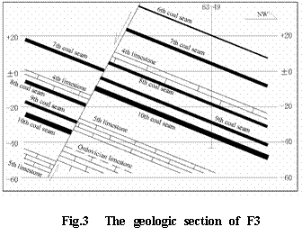
structures, fault structures play a major role in this area, faults can work as transmiting-water
channels, or collecting-water corridor, or hindering-water barriers [6], etc. If the capability
of transmiting-water
is well for some faults, they can communicate traversed aquifers and keep them
a unite hydraulic contact, such as F3 fault(Fig.1 and Fig.3).In reverse, if
capability of transmiting water for the others is very bad,
then, that will separate every aquifer and obstruct their hydraulic contact,
such as F23 fault(Fig.1).
Precipitation
is a primary way to recharge groundwater. its differences
with surface water and groundwater are not only showing in TDS but also in key
ions and the contents of organic matters. Commonly it have richer SO42 than the others, and its ion contents,
[SO42-]>[HCO3-]>[Cl-]. Its infiltration not only changes the
contents of main compositions and TDS of groundwater, but also changes the
oxidation-deoxidization conditions for having much dissolved oxygen,thus the quality of groundwater changes. Furthermore,
precipitation heightens the groundwater level, for instance, the water level in
Ordovician aquifer increase rapidly during 2004 to 2006, a main reason is the
rich precipitation recharge in this period.
4.2 Human factors
(1)Mine water discharging and groundwater exploitation. The water
sources of mine drainage are Permian System sandstone fissures water and
Carboniferous System lamina limestone karst fissures
water, while groundwater explotation is
mainly taken out from Ordovician limestone. According to some survey, the mean
annual drainage is 4.26107m3/a in this area. and groundwater exploitation amount
reached 2.08108 m3/a
in 1996, whereas 2.76108 m3/a
in 1998[7]. The original water level in Ordovician limestone aquifer
is +63m around, has been descended for years, and reached the lowest water
level -17.65m in July ,2003.
Both the human actions above make groundwater lever descend,
hydraulic gradient increase, erode effect strengthen, and the water flow rate
accelerate. Furthermore, because of descending of groundwater lever, the scopes
of unsaturated zone expand correspondingly and differences of water level in
different aquifers increase, which change hydrodynamic conditions and previous
oxidation-deoxidization conditions.
(2) Mine drainage irrigating.
As we know, water quality of mine drainage is worst among various samples. Due
to the lack of surface water, mine drainage is used directly to irrigate, then
irrigation water infiltrates in the underground and takes an adverse impact on
the soil environment, thus the whole groundwater environment is destroyed to a
certain extent.
(3)Sewage leakage in gangue stacks, which mainly affects shallow
groundwater. There are twelve gangue stacks like hills, and the occupied area
is 3.96 105m2 ,and
the annual amount of produced gangue is 1.10109 kg/a.
the open gangue contains sulphur, while it is exposed to rain drip and air
oxidation, it will create acidic water. If acidic water and other harmful
substances flow into surface water system or underground aquifers, they will
affect previous water quality. Moreover, if coal preparation waste water leaks that will also
bring disadvantageous effects [8].
As a whole, natural factors and human factors can be united to
work. For example, under mining conditions, geological structures such as
hindering- water faults can be aroused to transit water under human
disturbances.
5 Hydrogeologic Meanings
of the Evolution
5.1
Calculating approximately lateral recharge amount and renovate rate of
groundwater
In this area, if the infiltration coefficient adopts 0.3,then we
can calculate the precipitation recharge amount, that is 0.19108m3/a. Annual mine water drainage is 4.26107m3/a, present groundwater exploitation
assures 2.80108m3/a, then groundwater is reduced 3.04108m3/a, the reduced amount comes from
lateral recharge, and it is composed of all kinds of karst water coming from south, west,
northwest, east and northeast hill area(Fig.1). Since the groundwater levels
have been increasing in the past three years, so its lateral recharge amount is
more than 3.04108m3/a. If taking the thickness of 5th
limestone and Ordovician limestone as 830m and the rate of containing water as
0.1,then we can calculate that their water deposit amount is 81.34108m3, after ignoring confined elastic
deposit, groundwater renovate rate is(0.19+3.04)81.34=4%. Above these show that depth of water circulation is
augmenting and the evolution of groundwater environment is obviously
accelerating.
5.2 Making
an opinion to hydrogeochemical actions
Many hydrochemical actions
will happen when water flows in the subsurface, such as mix action. Taking mine
water as an example, for its recharge comes from 4th limestone and Ordovician
limestone, its quality type is HCO3—CaMg or HCO3SO4 —CaMg or HCO3—
5.3
Judging the way and extents of hydraulic contact among aquifers
The differences of the water quality and water level in space also
demonstrate the extents of the hydraulic
contacts among aquifers. If there are similar characteristics in water quality
and the trend of groundwater level regime that shows the hydraulic contacts among aquifers are intense. On the contrary, they are
inadequate. Here four types of hydraulic contacts are summarized from water
quality and water level, their ways and characteristics of hydraulic contacts
show as Table 3.
6
Conclusions
From the analyses above, we conclude that:
(1)In the Feicheng collery, the evolution of groundwater environment shows
ever-increasing remarkable change difference in space and time under human
influence. In space, water
quality has horizontal and vertical zone, the groundwater system is evolved to
man-made independent relatively circle system from natural open large system.
In time, the evolution of groundwater environment has been obviously
accelerating since 1960.
(2)Several important hydrogeologic meanings
were revealed from the evolution, they include that: Calculating approximately
lateral recharge amount and renovate rate of groundwater; Making an opinion tohydrogeochemical actions;
And judging the way and degree of hydraulic contact among aquifers,etc.
(3)There are five primary factors which contribute to the
evolution: geological structures ,atmospheric precipitation,
mine water discharging and groundwater exploitation, mine
drainage irrigating, and sewage
leakage of gangue stacks,etc.
(4)The work helps to validate the influences on hydrogeological conditions due to coal mine digging,
provide scientific guidance for digging deep coal bed and also make certain
some directions and goals for the utilization of mine water.
Acknowledgement
References
[1] Junxiang Xu,Pin Xu. Groundwater pollution and
control of
[2] Zonghu Zhang. Evolution of
groundwater environment in North China Plain.
[3] Zhen Ma,Yonghou Duan. The
sustainable utilization of groundwater resources in
[4] Weizhou Pang,Weiguo Liu. Hydrogeology in
coal mine.
[5] Zhaoli Shen etc.. Hydrogeochemical Basis (second edition).
[6] Dachun Wang,Renquan Zhang,Yihong Shi etc..
Hydrogeology basis,
[7] Jinming Li. Report about
general programming of mine resources in Tai’an, 2002,10-50
[8] Wen Wang etc..Development of coal resource and environment
protection. Mining safety and environment protection, 2003 (5)
[9] A.L. Mayo, E.C. Petersen, C. Kravits. Chemical evolution of coal mine drainage in a non-acid producing environment, Wasatch Plateau,Utah,USA.Journal of Hydrology. 2000, (236):1–16


