


Achievements
HYDROLOGIC FEATURES AND CLASSIFICATION OF EPIKARST SPRINGS IN SOUTHWEST CHINA
Zou Shengzhang1,2, Liang Bin2, Zhu Yuanfeng3, Xia R’yuan2, Tang Jiansheng2
1.China University of Geosciences, Beijing 100083,
2. Institute of Karst Geology, CAGS,
3.Qingdao Insitute of Marine Geology, Qingao 266071,
Abstract: It is significant for the regulation capacity of Epikarst zone to control the rock desertification and supply drinking water in the karst mountain areas where the water shortage is very serious. Based on a large number of field investigations which analyzed the characteristics of water circulation in the epikarst zone of Southwest China, three typical kinds of epikarst springs are summarized according to the ecological and environmental properties. They are as follows: epikarst springs in the forest environment, epikarst springs in the rock desertification environment, and epikarst springs in the rock desertification-forest transition environment. The development conditions and hydrologic characteristics of the three kinds of epikarst springs in Southwest China, especially in Luota karst area, are discussed in detail in the paper. Epikarst springs in the forest environments have a stable hydrologic regime and a continuous water flow, one of epikarst springs in the rock desertification environments is extremely unstable and in correspondence with precipitation, and to epikarst springs in the rock desertification-forest transition environments, the time of peak discharge is moderately delayed by the increase in the vegetation overcast rate of the spring basin. Classifying epikarst springs according to their environment types can directly indicate their particular hydrologic features which can help to the rational development and synthetic utilization of epikarst springs. The method was applied in Luota karst area and resulted in a new boundary for the epikarst study.
Key words: Epikarst spring; Forest environment; Rock desertification environment;Rock desertification-forest environment
1 Introduction
The term “epikarst zone” was put forward firstly by Mangin (1974). It is the uppermost layer of a karstified rock in which a large proportion of the fissures have been enlarged by solutional erosion. An epikarst allows rapid infiltration and some storage of large quantities of infiltration water. In karstic areas the epikarst may extend to a depth of several metres or may be absent altogether. Tyc (1996) pointed out the relevance of the epikarst zone in water quality variability, Julian and Yong (1995) built the conceptual model of the epikarst zone and Alexander(1997)discussed its role in karst morphogenesis. The epikarst zone has been studied widely as well in recent years in
To date, there are ~17 million people who still live in a water-shortage state in the karst mountain areas of Southwest China because of excessive deforestation, which results in serious rock desertification, in the past half century (Jiang et al. 2001). As one of important drinking water resources of local people in the karst mountain areas, epikarst springs have been an important and new aspect of geological survey in Southwest China. Thus, there is an important practical application for exploiting and utilizing epikarst springs to resolve the difficulty of supplying drinking water to sparsely dispersed residents and their livestock, and to resolve the problem of irrigation for some scattered farms in karst mountain areas of Southwest China.
Most studies on the epikarst are emphasized on the capacity of ground water regulation (Jiang et al. 2001; Guang 2000; Peter 1992a, 1992b) and the vulnerability assessment (Doerfliger et al. 1999), in which the environmental hydrogeologic maps need to be mapped. Among the actual environmental hydrogeologic maps, however, the epikarst springs are not classified correctly. Consequently, the characteristics, especially the available value of epikarst springs cannot be understood directly from the maps. It can supply a gap if the epikarst springs can be classified by taking into account the environment property, the distribution characteristics and the hydrologic regime features. It is significant for the epikarst springs to the rational utilization, the rock desertification control, and the ecosystem restoration in karst areas of Southwest China, and even the world. Thus, sustainable development of the social economy can be accelerated in the karst mountain areas.
2 Geology and Hydrogeology
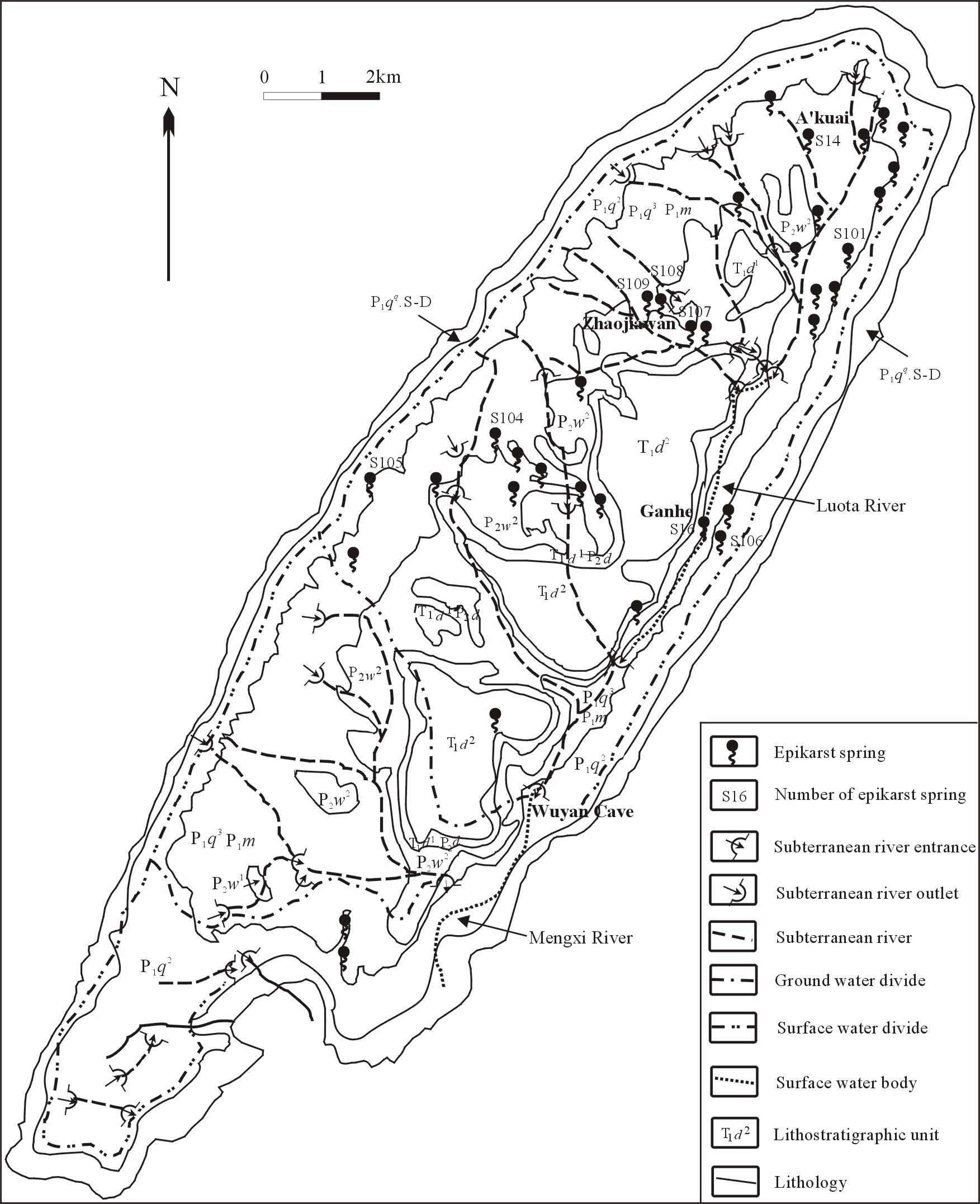
Luota karst area locates in the middle part of Longshan Country, west of Hunan, Southwest China. In the past, lots of studies have been conducted there (RGLKG 1984; Li 1995; Li et al. 2001; Liang et al. 2002; Lao et al. 2002; Liang et al. 2003). The conditions of karst hydrogeology are shown in Figure 1. The Luota karst area is a northeast-southwest trending anticline basin covering 119.07 km2. The upper outcrops, carbonate rocks, are Permian system and Triassic system covering ~90% of the whole area, about 555~720 m thick. The underlying Silurian sandstone, is believed to be a regional aquifuge.
In the Luota karst area bare karst is the main karst form, and the geomorphic forms are peak-cluster depressions, karst-mound depressions, etc. Additionally, the surface and underground karst features are well developed. There are 51 subterranean streams in the karst basin, but only one river, the
Lao et al. (2002) proved that epikarst zone develops widely in Luota, through the measures of outcrop stripping, trenching, drilling, and the water-pressure test. Epikarst springs are primarily distributed along gully edges and slope belts around depressions. The altitude of epikarst springs emerging is mostly between 500 m and 900 m above the sea level, in which most of the population live and epikarst springs are their main source of domestic water.
The strata of springs (including epikarst springs and other types of springs) emerging are the lower Permian series (P1m and P1q), the middle-lower Triassic series (T1-2j) and the lower Triassic series (T1dy). However, the strata of epikarst springs emerging are only the lower Permian series, P1m and P1q (Table 1), and none of epikarst springs are in the middle-lower Triassic series (T1-2j) and the lower Triassic series (T1dy) because of the difference between lithology and strata association.
Figure 1 Sketch map of karst hydrogeologic conditions in Luota
|
Table 1 Statistics on epikarst springs | ||||
|
Stratum |
Seasonal or perennial spring |
Number of springs |
Spring discharge (L/s) |
pH value |
|
P1m2 |
Seasonal |
9 |
0.001~0.07 |
7.30~7.85 |
|
Perennial |
4 |
0.05~6.00 |
7.18~8.70 | |
|
P1m1 |
Seasonal |
6 |
0.01~1.50 |
6.85~7.30 |
|
Perennial |
1 |
(0.20) |
(6.85) | |
|
P1q2 |
Seasonal |
3 |
0.01~1.00 |
7.13~7.39 |
|
Perennial |
1 |
(0.70) |
(7.23) | |
|
P1q1 |
Seasonal |
2 |
0.001~0.05 |
(7.35) |
|
The values are annual average values in parentheses. | ||||
There were 35 epikarst springs in the Luota karst area 10 years ago, but only 26 now; because the excessive deforestation results in some epikarst springs totally dry. It can be seen from the difference between Figure 1 and Figure 2. The stratum with the most number of epikarst springs (13) is the upper Member of Maokou Formation, lower Permian series (P1m2), but of these 10 discharge less than 1.0 L/s. In general, epikarst springs with discharge less than 0.1 L/s are seasonal spring, and those with more than 0.1 L/s are perennial spring. The main reason for the small discharge is that precipitation is the only source of recharge for epikarst springs.
3 Methodology
At the time of this study, 36 monitoring stations are in the study area. They are as followings: 6 weather stations, 1 monitoring station of surface water, 10 monitoring stations of ground water in the epikarst zone, 8 monitoring stations of ground water in the saturated zone, 5 monitoring stations of slope flow, 6 monitoring stations of soil water. The aim is to understand the relationship between the dynamic change of karst environments and the hydrologic features of epikarst springs. Several typical monitoring stations are shown in Figure 2.
Automatic monitoring of epikarst water is a very effective method to understand the dynamic change of quantity and quality of karst water. To date, the water level, temperature, pH value and conductivity have been monitored automatically in the subterranean river and several epikarst springs in different environments three times per hour. The instruments are automatic fluviograph, velocity flowmeter, orifice meter, and pH-conductivity meter. Because of limited funds, the discharge of epikarst springs is monitored artificially or semiautomatic method through triangular-notch and trapezoidal weir once every four days. The precipitation is monitored artificially twice every day. The frequency of soil monitoring is once every four days too.
The analytical methods for hydrologic features of epikarst springs adopt the method of water level variation-precipitation ratio (Chen et al. 1988), spring discharge summation (HEGTRT 1985), method of theoretical frequency (Tao 1997), flow field analysis (Engelen et al. 1987), and classification of water chemical composition (Zhang et al. 1995).
4 Types of Epikarst Springs and Factors Affecting their Development
Classification of epikarst springs in the study area
There are many methods of classifying springs (HEGTRT 1985). According to exposure conditions, the epikarst springs in the study area can be classified as suspended spring, erosional spring(descending spring), contacting spring, etc. Additionally, most epikarst springs belong to the class of karst fissure spring, with a shallow water level and a relatively instable hydrologic regime. Therefor, using the steady coefficient of spring, the ratio of minimum annual discharge to maximum annual discharge, epikarst springs can be classified as unstable springs (the ratio ~0.1 to 1) and extremely unstable springs (the ratio < 0.1).
At present, there are continuous in depth studies of the rock desertification control and ecosystem recovery in the karst mountain areas of Southwest China, and the exploitation and utilization of epikarst springs is an important issue. Because an individual epikarst spring may possess a lot of the foregoing properties, it is difficult to indicate the particular properties of an epikarst spring, especially the available value, if it is classified by the general classification methods. So it is necessary to devise a more suitable and more comprehensive methods to classify epikarst springs in studies on the rock desertification control and ecological recovery.
Figure 2. Map of environmental division in Luota karst basin
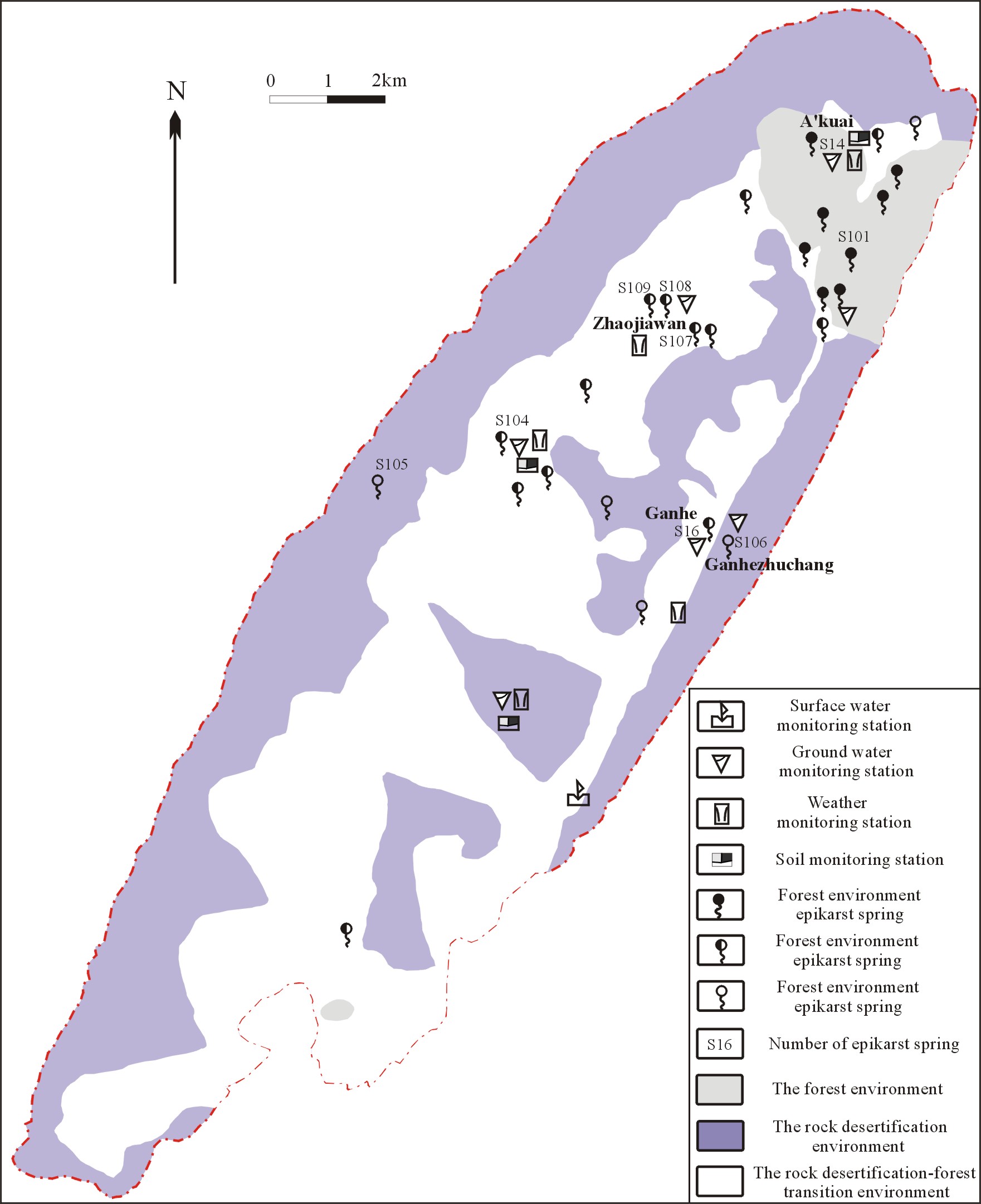
Based on a quantity of field investigations in which the circulation characteristics of ground water and surface-water in epikarst zone were analysed, three typical kinds of epikarst springs are summarized according to the ecological and environmental properties of their development. They are as follows: epikarst springs in the forest environment, epikarst springs in the rock desertification environment, and epikarst springs in the rock desertification-forest transitional environment. Figure 2 is the environmental division in Luota.
In this research, areas with over 30% bare rock are rock desertification environments, while those in which the rock is whole covered with trees (or shrubbery) are forest environments, and those in the intermediate stage are rock desertification-forest transition environments.
Factors affecting development of epikarst springs
Epikarst springs are the main mode of water discharge in the shallow karst zone. The developmental environment and the spatial construction of the epikarst zone determine the characteristics of water circulation in this zone, and thus determine the size and the regime characteristics of epikarst springs.
As a whole, the main factors affecting the development of epikarst springs are as follows: lithology, structure, geomorphology, karstification, spring-basin area, soil and vegetation (Jiang et al. 1999). Long term monitoring shows that the hydrologic regime of springs clearly correlates with the thickness and the developmental degree of the epikarst zone, the size of the catchment area, and the ecological condition.
The influence of the ecological environment on the hydrologic regime of karst ground water lies in that amplitude and lag-time of the hydrograph are different under different ecological conditions.Ecological condition is one of the main factors which influences precipitation infiltration. According to the statistical data on the ecological condition and discharge of epikarst springs during 1979-1980 and 2000-2001 (Table 2), shrubbery and semi-forest coverage obviously increased while the area of badlands and shrub-grassplots decreased with the conversion of cultivated land to un-irrigated artificial forests and the natural recovery of shrubbery and semi-forest. This obviously resulted in a change in the runoff of subterranean streams and epikarst springs, causing spring discharge to decrease in the rainy period and increase in the drought period. Taking Ganhe Spring (S16) as an example, the discharge in the rainy period and the drought period was 0.0377 L/s and 0.0032 L/s respectively in 1979, when there was less bosket (thicket) and semi-forest but shrub-badlands; however, under the same rainfall condition, after the natural recovery of shrubbery and semi-forest for 20 years, the discharge in the rainy period and the drought period was 0.0164 L/s and 0.0079 L/s respectively in 2001.
It is clear that recovery of the ecological environment decreases the hydrograph peak in the rainy period and delays the hydrograph regime in the drought period especially. Therefore, rehabilitation of forest in karst mountain areas is very important to improve the capacity of water resources regulation in epikarst zone.
5 Hydrologic Features of Different Epikarst Springs
The basic developmental characteristics of epikarst springs are as follows: small recharge area, short infiltration path, and generally unstable regime.
Tracing tests carried out in the Luota karst area show that several epikarst springs may compose a large karst water system at one time, and that a single spring may become an isolated smaller karst water system on its own.
|
Table 2 Ecological condition and regime change of karst water of Ganhe Spring (S16) | |||||||
|
Year |
Ecological conditions ( vegetation overcast rate) |
Rainy period |
Normal period |
Drought period | |||
|
Precipitation (mm) |
Average discharge (L/s) |
Precipitation (mm) |
Average discharge (L/s) |
Precipitation (mm) |
Average discharge (L/s) | ||
|
1979 |
Shrub-grassplot: 96.37% |
972.70 |
37.7 |
124.00 |
6.6 |
114.60 |
3.2 |
|
1980 |
1707.10 |
134.4 |
408.20 |
48.1 |
131.60 |
2.5 | |
|
2000 |
Shubbey: 92.97% Forest: 3.46% |
1087.60 |
50.1 |
322.40 |
8.9 |
194.60 |
10.4 |
|
2001 |
481.40 |
16.4 |
437.10 |
23.1 |
141.00 |
7.9 | |
Most epikarst spring basins belong to hydrogeologic units with small recharge area between 0.05 km2 and 0.15 km2. For example, though Ganhe spring (S16) has a relatively large spring basin, the catchment area is only ~0.717 km2. Due to steeper landforms, the hydraulic gradient of ground water runoff is generally larger; combined with a shorter runoff path, usually from one to several hundred meters; this results in a medium to fast rate of ground water runoff, but less discharge.
All epikarst springs, regardless of environmental type, have the same basic function mentioned above. Their differences lie in different recharge fashions and different regime characteristics. The hydrochemical variations of epikarst springs are quite different under different vegetation conditions (Yao et al. 2001; Zhang et al. 2003), because better vegetation conditions results in stronger microbial action and biochemical action which affect the hydrochemical components of karst water.
Hydrologic features of epikarst springs in the forest environment
In the forest enviroment bedrock is covered by vegetation and thicker Quaternary eluvial-drift sediment (usually 0.5 to 2.0 m). Rainwater first infiltrates into the Quaternary sediment covering the bedrock during rain; only some of the rainwater forms
a slope-surface runoff. Then, due to the regulation of Quaternary sediment the rainwater slowly and indirectly recharges the ground water underlying the epikarst zone. Thus, the slope-surface runoff can show the recharge of precipitation for epikarst spring, and can show the discharge characteristics of the epikarst spring as well (Jiang et al. 2001).
Vegetation regulates epikarst water in two ways. First is the regulation of water quantity. Because root systems contain water, rainfall cannot easily form a slope-surface runoff and thus infiltration recharge is increased. Second is the regulation of the runoff process. Soil and vegetation delay infiltrating water in the epikarst zone by converting the rainfall recharge form from an impulse input to more continuous drainage. Thus, in the forest environment epikarst springs have a more stable regime and do not run dry, regardless of their discharge.
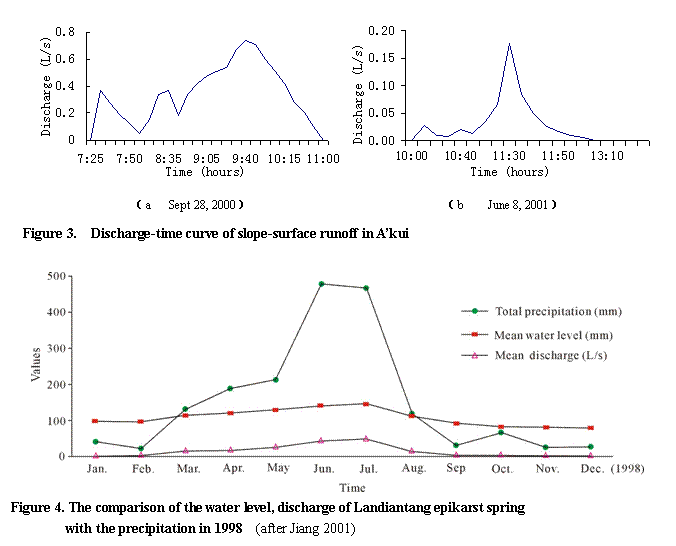
A typical epikarst spring in a forest environment is spring S14 in A’kui in Luota, covered entirely with trees. According to slope-surface runoff monitoring (Figure 3), runoff is formed when daily precipitation is >10mm or continuous precipitation >15mm, slope-surface runoff normally starts 30 to 45 minutes after rain commences, the runoff commonly has low intensity, and after rain the slope-surface discharge reduces gradually.
During a storm the maximal slope-surface runoff forms quickly, usually ~35 to 50 minutes after rain commences (Figure 3-a), and the slope-surface runoff lags 15 to 30 minutes behind the rain. To the longer light rain, the maximal slope-surface runoff occurs later than that of storm, usually ~2 to 3 hours after rain commences. And the duration of the maximal slope-surface runoff is extremely short (Figure 3-b) because of the regulation capacity of vegetation to precipitation.
Landiantang epikarst spring in Nongla, Guangxi, is also a representative epikarst spring in the forest environment (Jiang et al. 2001). Figure 4 is the comparison of the water level, discharge of Landiantang epikarst spring with the precipitation in 1998. In Figure 4, only one peak appears in the discharge curve with storms, it shows that the hysteresis effect of rainfall converting into ground water is obvious in the area of forest environment because of the regulation capacity of vegetation and epikarst zone to rain, especially light rain.
Hydrologic features of epikarst springs in the rock desertification environment
The capacity of the rock desertification environment to regulate water quantity is weak due to the bare bedrock, general lack of eluvial-drift sediment, and lower rate of vegetation coverage. During precipitation, water quickly infiltrates and recharges ground water in the epikarst zone directly through dense open surface solution fractures; thus, the recharge is both direct and rapid. The discharge and water level behave the unstable regime and have large fluctuations, and the discharge changes almost simultaneous with precipitation.
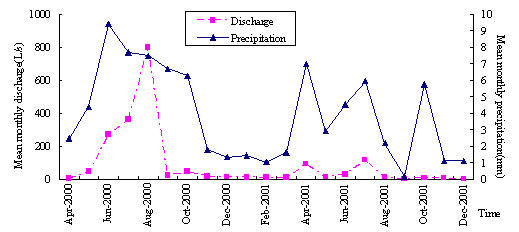
Figure 5 contrasts the average monthlydischarge with precipitationl at Ganhezhuchang spring (S106), the typical epikarst spring in a rock desertification environment. It lies in the east of the Luota Syncline which has an area of 0.132 km2. The water storage space of the epikarst zone is composed of a combination of karst forms (such as shallow karrens and solution fissures), bare bedrock and ~20% vegetated area. The research area has a volume karst factor of ~25%. Monitoring shows that the capacity of the spring basin system to regulate water quantity is quite weak; runoff is ~0.1 L/s and this spring is dry during the drought period.
In Figure 5, the discharge changes with the precipitation directly, which shows the sensitivity of rock desertification environment for precipitation, especially storm.
Figure 5. The mean monthly discharge and precipitation for Ganhezhuchang spring (S106)
Hydrologic features of epikarst springs in the rock desertification-forest transition environment
Zhaojiawan spring is the most representative epikarst spring in the rock desertification-forest transition environment. It is a group of springs comprised of three large springs, springs S107, S108, and S109. Of these springs S108 and S109 lie in the recharge area of spring S107. It developed in the lower Permian series (P1m and P1q), composed of limestone and dolomitic limestone. The recharge area is comprised of non-irrigated farmland or badlands with interlaced areas of artificial forest and shrubbery, and is semi-covered by vegetation. The recharge area of the spring area is 0.408 km2 in which several epikarst springs are distributed, forming a multilevel drainage system. Spring S107 is surrounded by artificial forest and its outlet elevation is 955.0 m.
According to the research and monitoring, springs S108 and S109 possess characteristics of the rock desertification environment epikarst springs: larger runoff regime change, sensitivity to rainfall, the limited regulation capacity, of which discharge changes significantly after it rains and decreases rapidly when rain stops, the lag time and flood peak fadeaway time is shorter. Usually, the regime lags less than an hour behind the rainfall.
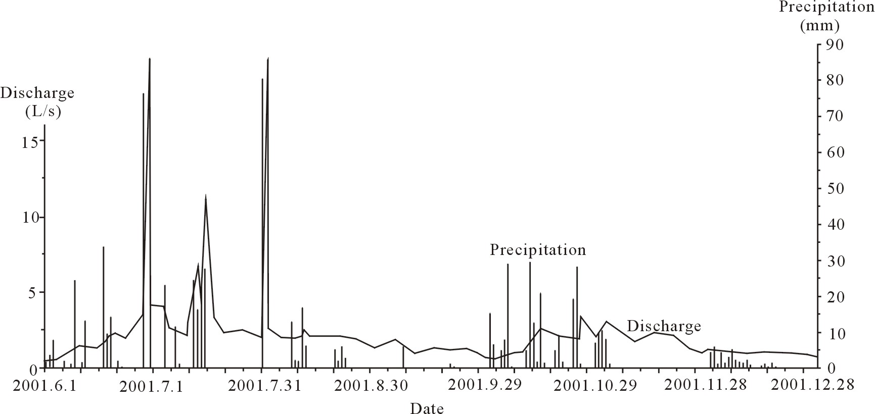
However, the discharge variation of spring S107 is small, and is closely related to the rainfall, e.g., the annual runoff is 6.85×10⁴ m3/yr, mean monthly runoff is between 0.966 L/s and 5.79 L/s, and the maximum runoff is 82.47 L/s (July 31, 2001). The hydrograph of spring S107 is sharply peaked (Figure 6). Additionally, the delay and the flood peak fadeaway of spring S107 are relatively longer than springs S108, and S109, and the spring is not dry in the drought period. This data show that the epikarst zone of spring S107 has the ability to store the karst water.
In some sense, epikarst springs in the rock desertification-forest transition environment have discharge times that are moderately delayed by the increase in the vegetation overcast rate in the spring basin
Figure 6. Discharge and precipitation for spring S107 in Zhaojiawan
6 Conclusions
Vegetation covers 45%~56% of the karst mountain areas of west
The key influence on karst water regulation effectiveness is ecological condition. Different types of soil overlay and different ecological conditions result in obvious differences in the regime change of karst ground water and the hysteresis effect of rainfall converting into ground water. The better the ecological condition is, the longer the ground water storage time and the greater the value of the karst water resources in terms of utilization. Therefore, rehabilitation of forest in karst mountain areas is very important to improve storage of epikarst zone water. But how the changes in ecological conditions affected the hydrologic processes resulting in changes in discharge is unknown now, which is the main aim in our future researches.
Classifying epikarst springs according to their environmental properties clearly indicates that ecological recovery has an important effect on potential water resources, and that converting cultivated land to artificial forest is important to resolve the water shortage problems in karst mountain areas. It is not only directly indicates their particular environmental properties, but also redounds to their rational development and synthetic utilization, the rock desertification control, and the ecosystem restoration, reflecting the usefulness of this classifying method.
Acknowledgments
This study was funded by the Science and Technology Fund under contract 20010303 and the Geological Survey Fund under contract 200310400043 of the Ministry of Land and Resources P.R.C. The authors wish to thank Miss Erin Lynch, graduate student of
References
[1] Alexander K. 1997. Epikarst: its nature, hydraulic functioning and the role in karst morphogenesis. In Proceedings of the International Congress of Speleology 12, Vol. 1, ed. Jeannin-Pierre-Yves, 306. U.S.A: International Union of Speleology.
[2] Chen Baoren, Hong Zaiji, and Wang Fuqi. 1988. Regime and forecast of ground water.
[3] Doerfliger N, Jeannin P Y, and Zwahlen F. 1999. Water vulnerability assessment in kasrt environments: a new method of defining protection areas using a multi-attribute approach and GIS tools (EPIK method). Environmental Geology 39: 165-176.
[4] Engelen G. B, and Jones P. 1987. Developments in the Analysis of Ground water Flow System. IAS publication.
[5] Guang Yaohua. 2000. Exploitation and utilization of water resources in the Guangxi karst areas. Carsologica Sinica 19:251-259.
[6] Hydrogeology and Engineering Geology Technique Research Group (HEGTRT) of the ministry of geology and mineral P.R.C. 1985. Hydrogeology Handbook.
[7] Jiang Guanghui, Guo Fang, Zhang Meiliang, He Shiyi, Li Enxiang, and Deng Yan. 2002. Character of karst dynamic system in Wanhuayan epikarst zone. Carsologica Sinica 21: 173-177.
[8] Jiang Zhongcheng. 1998. Features of epikarst zone in south
[9] Jiang Zhongcheng. 2000. Carbon cycle and ecological effects in epikarst systems in southern
[10] Jiang Zhongcheng, and Yuan Daoxian. 1999. Dynamics features of the epikarst zone and their significance in environments and resources. Acta Geoscientia Sinica 20: 302-308.
[11] Jiang Zhongcheng,
[12] Julian, H.E., and Young, S.C., 1995, Conceptual model of ground water flow in a mantled karst aquifer and effects of the epikarst zone. In: Karst geohazards--engineering and environmental problems in karst terrane, ed Beak,B.F., 131-139.
[13] Lao Wenke, Li Zhaolin, Luo Weiquan, and Liang Bin. 2002. Main features and classification of epikarst in Luota area. Carsologica Sinica 21: 30-35.
[14] Liang Bin, Li Zhaolin, and Zhu Yuanfeng. 2002. Sustainable development models of karst ecosystem in Luota. Carsologica Sinica 21: 290-298.
[15] Liang Xiaoping, Zhu Zhiwei, Liang Bin, Guan Bizhu, and Zou Shengzhang. 2003. Preliminary analysis on hydrogeochemical characteristics of the epikarst zone in Luota, Huanan. Carsologica Sinica 22: 103-109.
[16] Li Wenxing. 1995. The fractal bending of karst cave. Carsologica Sinica 14: 241-245.
[17] Li Zhaolin, Luo Weiquan, LaoWenke, and Liang Bin. 2001. Water resources exploitation, utilization and protection of Dgualadong underground river in
[18] Mangin A. 1974. Contribution a l’etude hydrodynamique des aquifers karstiques. Annales de Speleologi. 29: 283-332.
[19] Peter W Huntoon. 1992a. Hydrogeologic characteristics and deforestation of the stone forest karst aquifers of South China. Ground Water 30: 167-176.
[20] Peter W Huntoon. 1992b. Exploration and development of ground water from the stone forest karst aquifers of South China. Ground Water 30: 324-330.
[21] Research Group of Luota Karst Geology (RGLKG). 1984. Study on karst development and water resources assessment in Luota area.
[22] Research Group of Luota Karst Geology (RGLKG). 1984. Study on karst development and water resources assessment in Luota area.
[23] Song Linhua. 1997. Epikarst aquifer in fengcong regions, South China. In: Proceedings of the 12th international congress of Speleology, Vol.1, ed. Jeannin-Pierre-Yves, 319-321. U.S.A: International Union of Speleology.
[24] Tao Shuhua. 1997. Calculation and comment on theoretical frequency of discharge rate from two springs at Yuanjiapo and Shaizhudong in the northern area of
[25] Tyc, A. 1996. The nature of epikarst and its role in dispersed pollution of carbonate aquifers. In: Proceedings of International Conference: 'Karst-Fractured Aquifers - Vulnerability and Sustainability.
[26]
[27] Zhang Cheng. 1995. The application of Fuzzy Cluster analysis in karst hydrochemical classification. Carsologica Sinica 14: 9-17.
[28] Zhang Cheng, and Cao Jianhua. 2003. Seasonal and diurnal variation of physic-chemistry of typical epikarst springs under different vegetation. Carsologica Sinica 22: 1-5.