Achievements
REGIONAL STUDY OF GROUNDWATER CONTRIBUTION TO STREAM FLOW: A CASE STUDY IN KARUN BASIN IN IRAN
M. Reza Ghanbarpour1,Shabanali Gholami2,Elham Ahmadi3,Mehdi Teimouri4
1. Faculty
of Natural Resources, University of Mazandaran, P.O.Box: 737,
2. Soil Conservation and Watershed Management
Research Institute,
3. Regional and urban planning,
4. Faculty of Natural Resources, University of Mazandaran,
Abstract:Estimating
the amount of groundwater contributions to stream flow within a watershed is a
critical aspect of many hydrogeologic investigations. Determination of this
variable could be very challengeable due to uncertainty involving separation of
different parts of stream flow. The base flow in most watersheds can be assumed
as the water discharged from groundwater aquifers. In this study base flow
separation and regional analysis of effective variables were used to evaluate
the spatial variability of groundwater contributions. Recursive digital filter
with filter parameter of 0.925 were used to separate daily stream flow data
into direct runoff and base flow, which has been shown the most accurate base
flow separation methods in previous studies. Karun watershed in south west of
Key words: Groundwater, base flow, digital filter, regionalization.
Introduction
Determination of groundwater discharge is crucial for efficient water resources development as well as for water pollution management at the watershed scale. The total stream flow can be viewed as consisting of mostly two parts, direct runoff and baseflow. The direct runoff is the storm runoff that results from rainfall excess. The baseflow is the water discharged from groundwater aquifers. Estimating the monthly and annual volume of groundwater contributions to stream flow within a watershed is a critical aspect of many hydrogeologic investigations including water supply, irrigation planning, wastewater dilution, navigation, hydropower generation and aquifer recharge and characterization (Brutsaert & Nieber, 1977, Troch et al. 1993, Dingman, 1994, Szilagyi, 2004). Baseflow, which is a major component of streamflow, can be considered a reasonable approximation of groundwater discharge to a stream (White & Sloto, 1990, Holtschlag & Nicholas, 1998, Smakhtin, 2001). This is particularly useful for
numerical
groundwater-flow modeling researches. Some researchers (Hoos, 1990, Mau &
Winter, 1997, Rutledge & Daniel, 1994) have shown that baseflow can be used
to derive basin average estimates of groundwater recharge. In addition, an
understanding of the outflow process from groundwater is also essential in water
budgets and catchment’s response analysis. Numerous analytical techniques have
been developed to separate base flow from total stream flow (McCuen, 1998;
Nathan and McMahon, 1990). Ghanbarpour, et al. (2006) has shown that the
recursive digital filter base flow separation technique with the filter
parameter of 0.925 has the most accurate results in south west of
To study the regional pattern of BFI and contribution of groundwater to stream flow, relationship between several physiographic variables and the BFI were developed using stepwise multiple regression analysis.
The overall objective of this research is to gain a better understanding of the contribution of groundwater component of stream flow at different spatial scales. The most accurate regional model could be used to estimate the BFI of all hydrological units, which have not data observation. This study is intended as an important step toward improving the knowledge of the temporal and spatial baseflow characteristics of the basins of area, which is crucial to prevent groundwater depletion and pollution and to define a rule for establishment of conjunctive use in the region.
Methods and Aterials Study Area
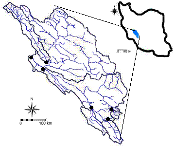
The Karun basin studied in this project is
located in the southwest of

Figure
1. Location of the study area in
Table 1. Details of the sub-basins under study
|
Basin |
Area (km2) |
Average annual runoff (m3 s-1) |
Elevation (m) |
|
Armand |
9900 |
100.2 |
1050 |
|
Barez |
8999 |
126.8 |
815 |
|
Batari |
885 |
16.6 |
1560 |
|
Dehkadeh |
200 |
5.3 |
2220 |
|
Morghak |
2146 |
74.3 |
860 |
|
Pole shaloo |
24141 |
341.9 |
800 |
|
Shah mokhtar |
1187 |
22.2 |
1730 |
Base FlowIndex (BFI)
BFI is a dimensionless ratio, which developed
by Lvovich (1979) and the
![]() (1)
(1)
where
![]() is
the filtered quick response at the kth sampling instant,
is
the filtered quick response at the kth sampling instant, ![]() is
the original stream flow, and
is
the original stream flow, and ![]() is
the filter parameter and
is
the filter parameter and ![]() is
the filtered base flow. The filter is passed over the data three times. The
parameter
is
the filtered base flow. The filter is passed over the data three times. The
parameter ![]() affects
the degree of attenuation, and the number of passes determines the degree of
smoothing. Nathan & McMahon (1990) found that the value of the filter
parameter that yielded the most acceptable base flow separation was in the
range of 0.9-0.95. They found that the simple digital filter with a parameter
set to 0.925 produced more accurate yields and repeatable results compared to
the simple smoothing and separation rules. They found that the results were
comparable to those obtained by using traditional graphical techniques.
Ghanbarpour et al. (2006) has shown that in Karun
basin filter parameter of 0.925 will has the most accurate results. The results
of that reseach were gained by using the comparison of the base flow separation
methods with recession analysis as a most reliable but at the same time very
time consuming technique. Although the recession analysis is very accurate but
this method is almost impractical and tedious when it should be applied to a
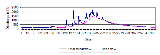
large number of basins furthermore they cannot be formulated. Figure 2 shows an
example of the graphical output of base flow separation for Pole Shaloo
hydrometric station using the recursive digital filter method for the water
year of 1979-80.
affects
the degree of attenuation, and the number of passes determines the degree of
smoothing. Nathan & McMahon (1990) found that the value of the filter
parameter that yielded the most acceptable base flow separation was in the
range of 0.9-0.95. They found that the simple digital filter with a parameter
set to 0.925 produced more accurate yields and repeatable results compared to
the simple smoothing and separation rules. They found that the results were
comparable to those obtained by using traditional graphical techniques.
Ghanbarpour et al. (2006) has shown that in Karun
basin filter parameter of 0.925 will has the most accurate results. The results
of that reseach were gained by using the comparison of the base flow separation
methods with recession analysis as a most reliable but at the same time very
time consuming technique. Although the recession analysis is very accurate but
this method is almost impractical and tedious when it should be applied to a
large number of basins furthermore they cannot be formulated. Figure 2 shows an
example of the graphical output of base flow separation for Pole Shaloo
hydrometric station using the recursive digital filter method for the water
year of 1979-80.
BFI has many practical applications, especially in rainfall-runoff modeling. Also it can be used as a basin characteristic to compare the flow characteristic of different basins. In this research the BFI values for fourteen basins using the selected baseflow separation method were calculated.
Regionalization of BFI
To study the regional pattern of BFI and
contribution of groundwater to stream flow, relationship between several
hydrologic and physiographic variables and the BFI were developed using
stepwise multiple regression analysis. As lacey and Grayson (1998) stated, base
flow is a function of a large number of variables that include topographic,
climatic and etc. Nathan et al. (1996) carried out a regression analysis for
base flow index in terms of a number of catchment properties for 164 catchments
in the state of
Results and discussion
In this research recursive digital filter with
the filter parameters of 0.925 were used to estimate base flow data series in
daily and monthly time scale in seven watersheds in south west of
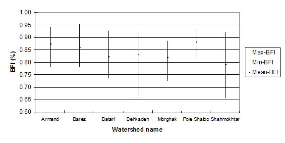
In this research, the monthly and annual BFI data series for all seven sub-basins were estimated using recursive digital filter method with parameter value of 0.925. Figure 3 shows summary statistics of mean, minimum and maximum annual BFI values for watershed under study. As can be seen in Figure 3, annual average of BFI varies from 0.79 to 0.88. It is evident that more than 80 percent of the annual stream flow could be considered as baseflow or groundwater discharge in the study area and similar basins.
To study the regional pattern of BFI and
contribution of groundwater to stream flow, relationship between several
hydrologic and physiographic variables and the BFI were developed using
stepwise multiple regression analysis. Base flow is a function of a large
number of variables. Therefore in this study some topographic and
hydro-climatic variables were considered to extract the regional relationship
for estimation of BFI. Area, weighted average of elevation, annual runoff, and
snowmelt runoff is the most important variables that we considered for this
research. The results of stepwise regressions using different sets of variables
have shown in Table 2. Significance percent of the regional relationships were
shown in Table 3. The regression analysis based on Table 2 and 3, indicated
that the best correlation was between BFI and the area of watersheds in square
kilometer. This relationship is significant at the 99% confidence level and ![]() is
equal to 0.685:
is
equal to 0.685:
![]() (2)
(2)
Where:
![]() is base flow index (%),
is base flow index (%),
![]() is watershed area (km2).
is watershed area (km2).
Eq. (2) could be used to estimate the average
annual BFI in all hydrological units in the study area, which are ungauged.
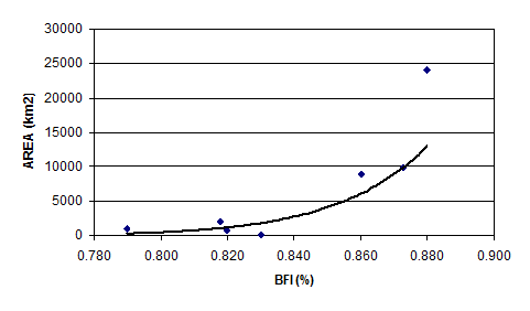
Figure 4 has shown the relationship between BFI and Area in study. As can be
seen in Table 2 and 3, there is a significant relationship between BFI and area
and annual runoff for the watersheds under study. On the other hand there are
unsignificant relationship between snowmelt runoff and elevation with BFI. As
can be seen in Table 2., when more than one variable is added to the equations,
![]() will
increased. On the other hand significance of the equation and also
incorrelation of the independent variables produce unsuitable models, regarding
to estimation of BFI for unguaged watershed in study area.
will
increased. On the other hand significance of the equation and also
incorrelation of the independent variables produce unsuitable models, regarding
to estimation of BFI for unguaged watershed in study area.

Figure 2. base flow separation results at the Pole Shaloo hydrometric station for the water year of 1979-80, based on recursive digital filter with the parameter value of 0.925.
 Figure3.
Variability of BFI (mean, Maximum and minimum) values in study area.
Table 2. regional models for estimation of BFI in study area.
|
No. |
Model |
R2 |
Std. E |
|
1 |
|
0.726 |
0.021 |
|
2 |
|
0.685 |
0.203 |
|
3 |
|
0.322 |
0.029 |
|
4 |
|
0.556 |
0.024 |
|
5 |
|
0.795 |
0.018 |
|
6 |
|
0.809 |
0.020 |
![]() is
base flow index (%),
is
base flow index (%), ![]() is
watershed area (km2),
is
watershed area (km2), ![]() is
average annual runoff (m3 s-1),
H is weighted average elevation of whole watershed (m), SWE is annual
estimated snowmelt runoff (mm).
is
average annual runoff (m3 s-1),
H is weighted average elevation of whole watershed (m), SWE is annual
estimated snowmelt runoff (mm).
Table 3. regional models for estimation of BFI in study area.
|
Model No. |
Variables |
Significant (%) |
|
1 |
A |
0.09 |
|
H |
0.631 | |
|
2 |
A |
0.022 |
|
3 |
SWE |
0.184 |
|
4 |
Q |
0.054 |
|
5 |
A |
0.97 |
|
Q |
0.217 | |
|
6 |
A |
0.181 |
|
Q |
0.673 | |
|
SWE |
0.277 |

Fig 4. Relationship between BFI and Area in study area
Conclusion
Estimating the contribution of groundwater recharge is an important aspect of many hydro-geologic and water resources investigations, especially numerical modeling and water budget analysis, at the watershed scale. In the case of water quality availability, base flow estimates can be integrated with this information to estimate groundwater loading. As an important application, groundwater discharge could be used in conjunction with land use change trends to investigate the effects changes in land management systems at the watershed scale, which is a critical aspect in water resources planning and management.
In this research, an automated base flow
separation technique, recursive digital filter was used to determine BFI values
for seven watersheds in south west of
Regional analysis of BFI in the area has shown that the most accurate relationship is exists between area and BFI in all watersheds under study. Because of intercorrelation and low significance of the multiple regressions equations, only model number 2 was selected as the most accurate model for regional estimation of the BFI at the unguaged watersheds in study area.
This research has shown that there is a significant dependency of groundwater contribution with watershed area. As can be seen in Figure3, BFI values in large watersheds are more in comparison with small watersheds. On the other hand, there are more differences between maximum and minimum of BFI values in small watershed, such as Dehkadeh and Shahmokhtar. Whereas, more variabilities of BFI can be seen in large watersheds such as Pole shaloo and Armand.
The results of this study could be used to define contribution of groundwater and base flow data series for ungauged basins in the region using regionalization procedures regarding to importance of low flow seasons with viewpoints of water quality and environmental consequences of drought periods. On average, groundwater discharge represented approximately more than 80% of total annual streamflow for the stations modeled. This highlights the importance of managing surface water and groundwater as a single interconnected resource.
References
[1] Brutsaert, W. And Nieber, J.L. (1977) Regionalized drought flow hydrographs from a mature glaciated plateau. Water Resources Research, 13(3), 637-643.
[2] Dingman, S.L. (1994) Physical hydrology, Prentice-Hall, Englewood Cliffs, N.J.
[3]
Ghanbarpour, M.R., Teimouri, M., and
[4] Holtschlag, D.J. and Nicholas, J.R. (1998) indirect ground-water discharges to the Great Lakes, U.S. Geological Survey Open-File Report 98-579, 25p.
[5] Hoos, A.B. (1990) Recharge rates and aquifer hydraulic characteristics for selected drainage basins in middle and east Tennessee, U.S. Geological Survey, Water-Resources Investigations Report 90-4015, 34p.
[6]
[7]
Lacey, G.C., and R.B.
Grayson (1998) relating base flow to catchment properties in south-eastern
[8]
Lvovich, M.I. (1979) World water resources and
their future. American Geophysical Union,
[9] Mau, D.P. and Winter, T.C. (1997) Estimating ground-water recharge from stream flow hydrographs for a small mountain watershed in a temperate humid climate, New Hampshire, USA: Groundwater, Vol. 35, No.2, p.291-304.
[10] McCuen, R.H. (1998) Hydrologic analysis and design. Second edition.
[11] Nathan, R.J. McMahon, T.A. (1990) Evaluation of automated techniques for base flow and recession analyses. Water Resources Research, Vol. 26, pp. 1465-1473.
[12] Nathan, R.J.,
[13] Rutledge, A.T. and Daniel, C.C. (1994) Testing an automated method to estimate ground-water recharge from stream flow records, Groundwater, Vol. 32, No. 2, p. 180-189.
[14] Smakhtin, V.U. (2001) Estimating continuous monthly base flow time series and their possible applications in the context of the ecological reserve. Water SA, Vol. 27, No. 2, 213-217.
[15] Szilagyi, J. (2004) Heuristic continuous base flow separation. Journal of Hydrologic Engineering, ASCE, 9:4(311-318).
[16] Troch, P.A. De Troch, F.P. and Brutsaert, W. (1993) Effective water table depth to describe initial conditions prior to storm rainfall in humid regions, Water Resources Research, 29(2), 427-434.
[17]
White, K.A. and Sloto, R.A. (1990) Base-flow
frequency characteristics of selected


