


Achievements
RESEARCH ON EVOLUTION OF WATER RESOURCES AND PATTERN OF GROUNDWATER EXPLOITATION IN HEIHE RIVER
Institute of Hydrogeology and Environmental Geology, CAGS,
Abstract: The paper, based on the natural-social environment
and utilization and evolution of water resources in the Heihe
River basin, describes the complex
mode of the
1 Introduction
The Heihe River
originates from Qilian Mountain, flowing through Qinghai,
Gansu and Inner Mongolia.
The river covers an area of about 140,000
km2, which is high in the southwest and low in the
northeast. The zoning is vertically apparent from landform,which is 2500~5826.6m at the altitude in the Qilian Mountains in the
south with modern glacier above 4000m,
and l000~1500m at the Hexi Corridor in the middle, 800~1500m in the Alashan plateau in the north. The upstream
of the
The basin is a typical continental monsoon
climate. The rainfall decreases gradually from east
to west, north to south and high to low. In the southern mountains the average
perennial temperature is -5~4℃, the rainfall 300~400mm. Snow is the important recharge to the river. In
the corridor, the climate is dry, the average perennial rainfall 88.8~171.7 mm, the average perennial surface evaporation l708.5~2503.5mm. Ejinaqi basin is extremely dry in the downstream.
The average perennial rainfall is 42.0mm,
evaporation amounting to 4135.8mm.
The climate is the long and cold winter with little snow in this area, but the
summer is hot with concentrated rainfall, and the temperature changes quickly
in spring and autumn. Heihe river system is composed of over 30 streams that
can be divided into two tributaries, of which the east branch the Heihe River
is the main river about 821km
long with the average perennial flow 1.591 billion m3. The west
branch is
Zhangye
named "golden Zhangye" is an important corn base in
2 Water Exploitation and Evolution in the
2.1 Utilization of water resources
Since 2000
years ago, the land had been cultivated with opening dyke, irrigated in the
Heihe basin. During that time, the local people were not more than 100,000
there in the Hexi Corridor. Gradually, the evolution turned from the natural
oasis to the artificial in Juyan area. In the recent 500 year or so, the
ancient oasis was dying out and the natural Ejina oasis grew. In the past 30
years, especially since the 1980s, the agriculture has been growing rapidly
with the irrigation area increasing from 50,000 hm2 in the 1950s
to 213,000 hm2 now in the middle stream area,
including the new cultivated land more than 3300 hm2 paddy fields. In 1999, the total water amount of
the
2.2 Evolution of surface water
The Zhengyi
Gorge and the Yingluo Gorge Stations were built on the
Man
activities leads to 8 times changes of runoff in the
Overall, the data show theat the flowing amount was normal at the Yingluo Gorge station from the 1950s to the 1990s as smooth changes, which was effected mainly by nature. The data show that the flowing amount at the Zhengyi Gorge Station was fairly rich in the 1950s, normal during 1960 and 1989, but the runoff was reduced dearly in the 1990s, which was taken as the fluctuation changes. The main reason is that man activities caused the reduction of runoff during the 1990s.
The changes of runoff at the Zhengyi Gorge rely not only on the water amount from the Yingluo Gorge, but also on the human activities with consumption of water between the two gorges (Fig. 3 and 4).
Figure 3 shows that the flow through the two stations have decreased in recent years and Figure 4 gives the data from the mid-stream river basin that the consumption of the river water was stable with 460 million m3/a, representing 29% of total runoff before 1979. The increase of river water consumption started in the period of 1980~1984 with 590 million m3/a, accounting for 37.3% of total runoff and during 1985~1989 the average 683 million m3/a, accounting for 43.2% of the total runoff. The difference began from the natural dynamic runoff to the artificial dynamic process. Since 1990, the exhausted period of the natural runoff started by consuming 812 million m3/a, accounting for 51.4% of total runoff that has exceeded 50% over years that clearly shows the fact of the artificial control.

Fig.1 Runoff at the Yingluoxia Station

Fig.2 Runoff at the Zhengyixia Station
Table 1 Characteristics of perennial runoff at Yingluoxia and Zhengyixia stations
|
Location |
Height (m) |
Average runoff (108m3) |
Runoff at various conditions (108m3) |
Wmax/ Wmin |
Mean different coefficient(Cv) | ||
|
P=50% |
P=75% |
P=95% | |||||
|
Yingluoxia
Zhengyixia |
1710
1270 |
15.91 (1944—2000) 10.42 (1950—1998) |
15.7
10.35 |
14.6
8.72 |
12.6
5.48 |
2.09
8.36. |
0.16
1.48 |
Table 2 Comparison of runoff in
different periods of the
|
Item
Station |
1950s |
1960s |
1970s |
1980s |
1990s | |||||||
|
Value of departure |
Departure (%) |
Value of departure |
Departure (%) |
Value of departure |
Departure (%) |
Value of departure |
Departure (%) |
Value of departure |
Departure (%) | |||
|
Yingluo xia |
1.43 |
8.89 |
-1.05 |
-6.53 |
-1.24 |
-7.71 |
1.36 |
8.46 |
-0.52 |
-3.23 | ||
|
|
|
|
|
| ||||||||
|
Zhengyi xia |
1.41 |
13.53 |
0.11 |
1.06 |
0.21 |
2.02 |
0.60 |
5.76 |
-3.07 |
-29.46 | ||
|
Higher |
|
|
|
Lower | ||||||||
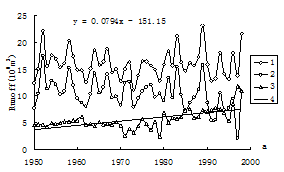
Fig.3 Yingluoxia and Zhengyixia’s runoff and difference value
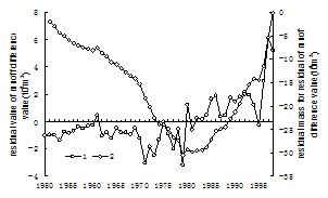
Fig.4 Changes of Yingluoxia and Zhengyixia’s residual mass of runoff difference value
1-Yingluoxia; 2- Zhengyixia; 3- runoff difference value 1-residual value of runoff difference value;
4-runoff difference value trend 2-residual mass of runoff difference value
2.3 Groundwater evolution
Groundwater occurs mainly in the middle and downstream basin where the giant thick Quaternary sediment provides a good condition for the aquifers which can be divided into the unconfined and confined groundwater systems. The unconfined aquifer is spreading over Zhangye and Jiuquan basins and the north part of the Dingxin basin and eastern part of the Ejina basin. The yield from most of the wells only 5m deep is about 1000~5000m3/d in the middle reaches area, the downstream is about 100~1000m3/d. With the construction of water projects groundwater evolution in the basin is as follows:
2.3.1 The poorer groundwater recharge conditions, the less quantity recharged
One is the flow in the river course decreases year after year and another is the low seepage from ditches to recharge groundwater, which has taken place of the high infiltration from the river course, mainly from Gobi changed to the fine soil. A third, groundwater extraction caused the water level lowered and the effective recharge to groundwater decreased. At last, the river course becomes dry and no source recharges to groundwater. The calculation shows the result that groundwater recharge was reduced in the late 1990s of 0.99billion m3/a in the midstream area. The recharge now in the downstream area has decreased of 51.5% than the early 1980s (Table 3).
2.3.2 Springs disappearing, efficiency of water reuse reducing
Spring is kind of water resources which come from other regions and overflow in this area. The construction of water conservancy and over-exploitation of groundwater caused springs dramatically decreased. The statistics shows the discharges were 0.182 billion m3/a, 0.16 billion m3/a and 0.14 billion m3/a in the 1960s, in the 1970s and in the late 1990s respectively. The latter is reduced 0.84 billion m3/a of that in the early 1960s.
2.3.3 Dropdown of the regional groundwater level with local water quality deteriorated
In the
midstream of the
Table 3 Groundwater recharge in the middle reaches of
|
Period |
Late 1950s |
Middle 1960s |
Late 1970s |
Late 1990s |
|
Recharge(109m3/a) |
36.5 |
32.9 |
28.3 |
26.6 |

Fig.5 Groundwater dynamics from No. 65 well at Minle

Fig.6 Groundwater dynamics from No. 7 well at Gaotai
3 Analysis of Evolution Mode of the
In view of
the Heihe River
cycle, the
14C dating shows that there exist not only groundwater transformation which lasts over 40 to 55 years in the basin, also the water transformation less than 35 years in shallow groundwater in the local areas of the basin.
All in all, the man controlled development of water resources in the midstream area not only impacts the runoff downstream in the Heihe basin, but also changes completely the recharge to groundwater, the water level dynamics and spring occurrence downstream. All these have led to serious ecological problems. The Heihe water cycle evolution can be summarized as "natural water from mountain- man-control in the plain complex cycle evolution mode". It can be also divided as the upstream mountainous natural flow, off-composite artificial landscape (Yongjian Ding, 1999; Jinye Wang, 1999), the midstream natural-runoff evolution impacted by man activities of direct consumption and utilization above 86%, and the downstream passive accepting water, which is called the man controlled complex process.
Groundwater evolution system in the Heihe basin becomes an important part of "natural water from mountain- man-control in the plain complex cycle evolution mode". Therefore, the analysis should be from many aspects such as the natural recharge to groundwater, runoff and natural drainage impacted by human activities.
Groundwater
recharge derives mainly from the
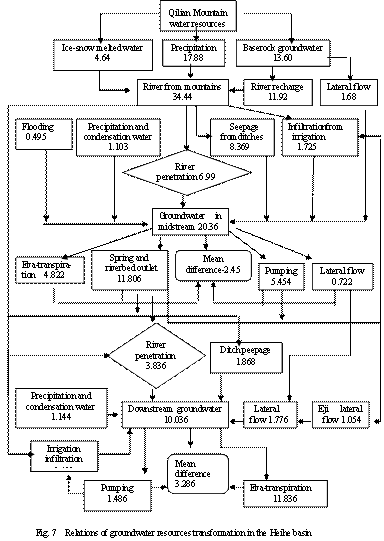
Groundwater flow pattern, due to the man disturbance and reduction of the natural recharge from the river course, changed its lateral runoff in the alluvial-proluvial fans. At the same time,the expanding irrigation results in the alternation of vertical infiltration in small territories. Therefore, groundwater runoff can be summarized as runoff degradation evolution from the lateral runoff to the artificial vertical recharge and the runoff flowing to pumping wells in some local area.
Groundwater resources is needed in the total basin from about 1.5 billion m3/a 50 years ago to the current 2.62 billion m3/a, especially in the midstream area where the consumption of water resources is about 2.45 billion m3/a of which 95% percent is used for irrigation, but 70% of the total amount is extravagant. As a result, the water for ecological environment decreases. Groundwater drainage cannot be taken as the only local drainage. The pumping field cannot be out of view. Therefore, groundwater drainage can be regarded as the evolution from the natural drainage to the manual mining. This drainage evolution is a kind of primary use for groundwater resources in which the groundwater extraction is taken a main part. The problems remain as springs are not taken as reusing water recourse to be effectively protected, so that the water reuse efficiency is reduced; another is that groundwater is used without considering the effective conservation and keeping ecological balance. So it is unsustainable.
The result shows that the
4
Mode of Exploitation of the Water Resource in the
So far, water resource of the
4.1 Surface water, groundwater storage-control exploitation in Gobi zone
The area lies near the mountainous area. Groundwater level is generally above 10m. The aquifer is thick and wide distributed in this area with large storage space, stable ability of water supply. It is uneasy polluted, little loss of evaporation, and taken as the main groundwater recharge area, which is suitable for groundwater regulation and exploitation. This area should be well protected for regulation of groundwater sustainability and stable development and anti-penetration measures should be avoided to keep surface and groundwater efficient transformation..
4.2 Exploitation and water-soil ecology environment integrative in Midstream oasis
This area is wide distribution of irrigation areas
in the midstream of the Heihe River such as Zhangye basin, Jiuquan basin and
The first subzone: water resource is not abundant, groundwater table 5~7m. the further desertification should be prevented. Surface water shoud be used for irrigation. It lies in the outlying oasis areas.
The second subzone: water resource is abundant for ecology, groundwater tasble is less than 3m. Soil further salinization should be prevente in this area. Integrate irrigation with drainage and reduction of evaporation loss should be taken.
The third subzone: Water resource is not abundant for ecology, groundwater table about 3-5m. Surface water with groundwater properly exploited can be taken for this area, and spring can be considered if the condition is acceptable.
4.3 Exploitation with avoiding land desertification in downstream area
It is mainly in Ejinaqi basin. The key point is that water resources exploitation and utilization should avoid the degradation of the ecological environment, based on the stable supply for the existing industrial-agricultural and domestic operation. Some engineering measures should appropriately be taken to improve natural environment. It can also be divided into three subzones:
The first subzone: water table is above 5 m, and river water should be used and natural leakage from river beds should be kept with good quantities to recharge groundwater, for groundwater is the most important to keep the ecological environment in Ejinaqi basin. Only in this way can vegetation coverage ratio be improved.
The second subzone: Water table is between 3-5 m, and this buried depth is good for most vegetation growth. The land quality is poorer due to the thin soil in Ejina basin. The degradation of vegetation is serious effected by a variety of disturbance. The way to be chosen is to plant suitable grasses in the area and resume the desertification vegetation in a short period.
The third subzone: Water table is less than 3m. Groundwater can be exploited to keep the water table stable. Appropriate ranching, farming and efficient ecology is the purpose in this area.
5 Conclusions
In the 1950s,
the
Generally, the Heihe basin is compound pattern of natural water resources from the mountains and artificial control in the plain. The natural runoff comes from the upper mountainous area, and natural-artificial runoff pattern in the mid-downstream basin. The natural recharge reduced and the man-effected recharge increased is dominant now in the plain. The runoff changes from the lateral to the artificial vertical recharge in the fan area, and some local areas turn to flow to pumping wells. The discharge pattern has become the natural drainage decreasing and the artificial exploitation increasing. It is not a sustainable exploitation evolution.
The proposed reasonable exploitation pattern in the Heihe River basin is as follows: The compound ways of surface water in the Gobi area, groundwater storage and control exploitation in the upstream, water resource exploitation and water-soil ecological environment integrative in oasis, and water resource exploitation with avoiding land desertification in downstream should be taken and protective construction in upstream, and reduction of excessive water waste in midstream, basin groundwater protection in middle basin, river stability in downstream, reduction of evaporation losses, man exploitation regularity may play an important role in achieving effective protection of the ecological environment.
Reference
[1] Chen Mengxiong,1997,The water resources related with Quaternary basin system arid area of Northwest China[J] Quaternary sciences, (2):98-104. (in Chinese)
[2] Ding Yongjian,Ye Baisheng,Liu Shiyin , Effect of climatic factors on stream flow in the alpine catchment of the Qilian mountains [J]. Geographical Journal, Vol.54, No.5:431-436. (in Chinese)
[3] The codification Committee of chorography Ejinaqi,1998[M] Local Chorography Press, 1-45,48,60,123-125,239. (in Chinese)
[4] Lan Yongchao, KangErsi,Jin Huiun,1999, Study on the variation characteristics and trends of mountainous runoff in the Heihe river basin [J], Journal of glaciology and geocryology, 21 volumes, No.1:49-53.
[5] Lu Yaoru,Tong Guobang,Guo Yonghai,ect, The research of 3 million to geological - ecological environment and its future trends in the evolution of China [A].Qu Hwanlin, Geological environment of human survival [C].Beijing :Geological Press,1998.63-74. (in Chinese)
[6] Liu Shaoyu, Lu Yaoru,Cheng Xuxue,ect, 2002,Groundwater system and water resources environment effect induced by water esources Development in the Middle and Lower reaches of the Heihe river [J].Geography and Territorial Research,Vol.18,No.4:90-96. (in Chinese)
[7] Tan Jianan, 1964, The desert types in Inner Mongolia Alashan [A], Geographic series, No.8:1-27.
[8] Tang Jingshen,1983, Test positive to reclaim farmland of Hexi area in Ming-Qing dynasty[J],Journal of Lanzhou University (social sciences edition),(4):86-92. (in Chinese)
[9] Wang Tao, Chen Guangting,Qian Zhengan,ect, 2001, Situation of sand-dust storms and countermeasures in North China, Journal of desert research, Vol. 21 ,No. 4: 322-327. (in Chinese).
[10] Wjinye,CheKejun,YanKelin,ect.,
1999,Analysis river runoff composition in the forest cover areas of the
[11] Xiao Shengchun, Xiao Honglang, 2003, Influencing factors of oasis evolution in Heihe river basin [J] Journal of desert research,Vol.23,No.4:385-390. (in Chinese).
[12] Xiao Shengchun , Xiao Honglang , Song Yaoxuan,ect., 2004,Water Land Resources Utilization and Environmental Evolution in Middle to Lower Reaches of Heihe River Basin during the Past 2000 Years,Journal of desert research,Vol.24,No.4,Jul:405-408. (in Chinese)
[13] Zhao Yong fu, 1986, The farming-grazing vicissitude in historical period in Hexi Corridor [J], Journal of history geography, fourth: 75-87. (in Chinese)
[14] Zhu Zhenda, Liu Shu,Gao Qianzhao,ect.,1983, The environmental Chges and desertification processes in historical period in the areas of ancient Juyan-Heicheng region in Western inner Mongolia [J] Journal of desert research, 3 (2):1-8. (in Chinese)