


Achievements
THE EXPLOITATION OF EMERGENCY GROUNDWATER SOURCE AT LARHE CITY IN NORTH OF CHINA
Yang Yuxin, Lin Jianwang, Li Jun, Sun Baocheng, Lin Li, Li Bo
Tianjin Geothermal
Exploration and Development-designing Institute,
Abstract: As large city’s emergency water source,
underground water resource is regarded by the government.
Keywords: emergency water source site, syncline, pumping test, designing of well
1 Introuduction
Tianjin is located in the north of
water into the development district. Groundwater field
is located in the north of Ninghe county, geographical range is longitude 117°43′21″~117°56′00″ east,latitude 39°24′57″~39°36′00″ north, include six villages and towns, namely, Yuelongzhuang, Houjituo, Xiaolizhuang, Fengtai, Banqiao and Miaozhuang, the aquiferous layer is Ordovician. Although done some particular explorations in the field, there are still difficulty and risk at exploitation due to insufficiency of precision. Therefore, farther exploration is carried out in this groundwater well field by using explore-exploit method.
2 General Situation of Groundwater Source
2.1 Geology condition
Ninghebei
district is situated on middle of Baodi~

Fig1. Areal structure of Chezhoushan district
(1)Axial stretch is NE, almost vertical with regional stretch NWW.
(2)The core of syncline consist with Carboniferous to Permian System, the core of anticline is made up of middle-upper Proterozoic.
(3)Because of the breakdown by faults, the stratum of two limbs change gentle or steep, become unsymmetry, such as Chezhoushan syncline, Beiziyuan anticline and Kaiping syncline.
(4) In a general way, the structure of anticline and syncline vanish at the
south of Jiyunhe fault, except core of Chezhoushan syncline, which vanish at
the
Ninghebei emergency groundwater well field is situated in
Chezhoushan syncline. Axial of Chezhoushan syncline spread from Xishuangzhuang
Ninghe county to Xinzhuangzi Fengrun
2.2 Regional hydrogeology characteristic
Ninghebei groundwater belong to FengrunChezhoushan groundwater system, the distribution range is same with the Huanxianghe surface water system, groundwater system is divided by mountain in north of area. At piedmont, stream water recharge the groundwater, and the groundwater boundary is controlled
by the structure of alluvial fan, this groundwater system is divided into three subsystem, namely Shanqu subsystem, Huanxianghe subsystem, Chezhoushan subsystem(figure 2). The distribution area of the Paleozoic of the Chezhoushan syncline is 721 km2, precipitation recharge area is 1120 km2
2.3Hydrogeology character of groundwater field
Chezhoushan
syncline stretch NE to SW, in surface, there is only 0.069 km2 emergence area of the Ordovician
limestone near the
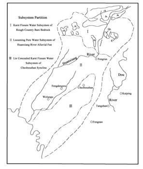
Fig2. Distributing of ground water system
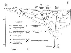
Fig3. Plane section of Chezhoushan ground water system
about 59 km2. The discharge is exploitation mostly.
The karst of Chezhoushan syncline is controlled by lithology, structure and ancient erosion surface. The lithology of Majiagou group of Ordovician is pure and rich in calcrete, crack and karst is flourish. The depth of Carboniferous System to Permian System in axial region of Chezhoushan syncline is 200 m to 400 m, and depth of Ordovician is 400 m to 600 m at limbs, so limestone stand in downfold of ancient landform, which covered by cailloutis layer of river deposit, top area of the limbs is ancient river in Pleistocene Epoch, the montane run-off lead to solution of rock and yield karst cave and subterranean stream.
3 Design of Groundwater Exploitation
3.1 General designing
According to hydrogeologic feature of groundwater well field explored before, we chiefly exploit the limestone aquifer of the Ordovician. For its good connectivity and unified hydraulic connection, mass pumping water can be carried from one or several parts of aquifer.
We determine to exploit at Dongjituo、Limaqu and Miaozhuang village. Because of deficiency of the geological condition, we need to do some seism and investigation work.
We decided to exploit this groundwater source by explore-exploit together and then gradual execution. Particular contents include:
(1) Carry out hydrogeology investigation to find the hydrogeologic condition of recharge、runoff、discharge in Chezhoushan syncline;
(2) Drilling engineering of the first stage locate 7 exploratory wells at Dongjituo district, depth of every well is about 800 m , total drilling depth reach 5600 m, water-yield capacity will reach 5.0×10⁴m3 , 5 wells at Limaqu district, depth is 850 m, total drilling depth reach 4250 m, water-yield capacity will reached to 2.4×10⁴m2 ; 2 observation wells at Miaozhuang district (south of Jiyun River), at the depth of 1400 m, total drilling depth reach 2800 m; Drilling engineering of second stage: locate 4 exploratory wells at Miaozhuang district of the third water source site, at the depth of 1400m, total drilling depth reach 5600 m, water-yield capacity will reach to 2.0×10⁴ m3;
(3)Man-made earthquake to investigate geology condition of this district, which provide basis of 4 exploratory wells at Miaozhuang district;
(4)Pumping test to ensure potential of the underground water output of the groundwater well field;
(5)Evaluate the groundwater resource and environment problem base on of long-term monitoring.
3.2 First adjustment of well designing
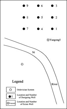
At first, 3 wells are drilled at Dongjituo district of the first groundwater well site, engineering goes well and water-yield capacity exceed designing, and this indicated that exploitation of groundwater can be increase. Contrasting with similar groundwater well field, the Ordovician System is rich in karst, the hydraulic of groundwater connect closely, and the waterlevel of groundwater change is “equiamplitude and in-phase” in the both wins of Chezhoushan syncline, this conclusion is proved to be true by fact. Because the aquifer is fragmentized, it is hard to drill. Considering future pipe laying and ground pipeline designing and ensuring total designed water-yield capacity, exploratory wells, which belong to Limaqu district of the second groundwater well site, are located at Dongjituo district. New arrangement chart of engineering after adjustment sees at figure 4.
The estimated water capacity of Dongjituo district will reach to 72000 m2/d. 9 production wells in north of Yuegong5 well are designed, 3 wells at every row. Distance between east-west is 25 m, and north-south is 20m; 3 observation wells include 1 well of the Ordovician and 2 wells of the Tertiary System. The information of different aquifers is gotten directly by the separate monitoring of the 3 wells
3.3 Second adjustment of designing well
Because water-yield capacity of first stage is much more than designing, and manual earthquake shows Miaozhuang district of third water source site is complicated in geology condition, we decided to merge third water source site to first water source site at Dongjituo district. Wells position arrangement of
|
Fig4. Well location of first stage |
second stage sees figure 5. Exploratory wells of second stage located around first stage, namely 6 exploratory wells located at west and north of first stage, distance between east-west is 25m, and north-south is 20 m. Total exploratory wells of two stages at Dongjituo district are 15 and 3 observation wells.The engineering complete successfully in 2002.
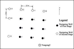
Fig5. Well location of second stage
4Verification of Pumping Test
4.1 Situation of pumping test
The groundwater well field carried on a large multiple-well pumping test with 3 groundwater level draw down from 26th March to 20th July 2003(figure6). Its purpose is to make sure of the potential of the field. The first drawdown is pumping with the largest discharge, the production is stable at 5.8×10⁴ m3/d and the water level is basically stable after 17 days from beginning. The water level of the closest observation hole Yuegong5 is stable at -35.58 m. The water level of the observation hole Yuegong4 is stable at -29.9 m, which is 650 m far away. The water level of the observation well Yuegong3 is stable at -18.93 m, which is 6400 m far way. The water level of the Che59 well is stable at -10.80 m, and stable time is about 52 days. The flow rate is tinily adjusted in this period. The change of water level is positive correlation with the flow rate. It indicate dynamic balance have been set up between recharge and discharge during the period. The total flow rate of the second drawdown is 4.0×10⁴ m3/d. The duration of pumping is 7 days and the time of stable waterlevel is 1 days. The produced quantity of the third drawdown is 2.2×10⁴ m3/d. The duration of pumping is 10 days and the time of stable water level is 4 days. Whereafter, the recovery water level measurement has been done for 31 days. The final water level recovers to -12.18 m, which is different about 2.5 m with the static groundwater level.
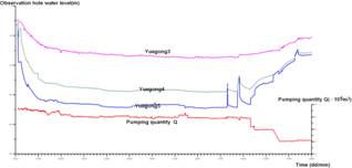
Fig6. Duration curve of pumping
From the pumping test analysis, the actual pumping capacity is less than or equal to the recharge capacity under the condition of this exploiting. Because the pumping test is carried out in dry season, the minimum capacity to exploit can be ensured, the permission pumping capacity is 5.8×10⁴ m3/d which concludes from pumping test.
4.2 Analysis of pumping test
Considered pumping district as a “big well”, the observation well Yuegong5 were “borehole wall”, because exploitation stratum is barefoot finishing, water level of borehole wall can be considered as water level of “big well”.
The first time pumping with a large discharge, the pumping quantity is stable at 5.8×10⁴ m3/d, the water level is stable at -30.04m and stability time is 54 days.
The second time pumping with a median discharge, the pumping quantity is stable at 4.0×10⁴ m3/d, the water level is stable at -21.67m and stability time is 1 day.
The third time pumping with a low discharge, the pumping quantity is stable at 2.2×10⁴ m3/d, the water level is stable at -12.85m and stability time is 4 days.
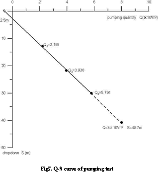
According to the results of pumping test, Q=f(s) curve of three different pump output (figure 7) is linear relation, but not intersect at origin, 2.5m lower than origin. Because pumping test spanning entire winter, fit to 2.5 m of water level annual amplitude
4.3 Produced quantity calculation by pumping test
According to pumping test, we can guestimate that produced quantity of 8.0×10⁴ m3/d is reliable, dropdown is 40.7 m and water level is about -49.43 m.
Additional remarks, large numbers of underground water exploitation will result in underground water level descend year by year. Underground water produced quantity of headwater area reached to 2.2×10⁸ m3/a~2.4×108 m3/a from 1992 to 1995, which lead Quaternary System shallow groundwater level and deep groundwater level descend 0.5m/a. The water source site exploits about 8.0×10⁴m3 every day, and water stage fluctuation may be more than 0.5 m.
5Effective Replenishment of Well Structure
After explorative pumping test, through downhole video scanner, we found 11 of 15 wells have different extent problems such as cave in、drop、boil of sand、clog、etc. This is because of large scale explorative pumping test, make hydropower field emerge negative pressure. Geology condition of located well is complicated; karst fissure developed very well and rock formation breaking up. Cave in not only occur at weathering crust of Ordovician System, but also occur at uncased borehole part of well completion. All about conclusion educed from the analysis of 8 cave in well. One the one hand it shows that this district has good water output condition; on the other hand it results in rock skeleton and pore space filler moved to well and make well ball up、cave in、etc. Considering long term water supply of water source site, large scale of pumping will aggravate cave in for the future, for avoid risk、reduce maintain fees and prolong serviceable life, we reinforce wall of a well by laid well tube filter.
Generally, well tube filter will reduce water-yield capacity, but karst blatt in here is well developed and abundant to supply. Guarantee porosity of well tube filter is not too small, and span of water-yield capacity is acceptable, we found that water-yield capacity increase 10% refer to pumping condition of well number 4 and number 11 tested before, which show the way laid well tube filter is feasible. We using petroleum casing pipe as well tube filter, porosity of borepipe more than 12%. Considering strength of breast wall borepipe suitable we using plasma incise, which will not change characters by heating, and water-yield capacity will be stable whether laid well tube filter. Practice proved that this is the best way to guarantee long term water supply of water source site.
6 Conclusions
The exploitation of Ninghebei groundwater well field have been carried out for 34 months, we obtain anticipated water-yield capacity and save one forth of plan’s investment, finally, guarantee emergency use of the city.
The Explore-exploit combined method is used in the project, exploitation is the purpose and exploration is the means. Only if find the structure of groundwater storage, water-yield capacity can be guaranteed. During the project, from designing of drilling well, location adjustment, pattern of well selection, optimization design is selected according to practical situation. Therefore, we get success of drilling engineering, no failing well and dry well.
From the other side of the engineering, reduce of the conveyance system and power supply line is the most contribution to this engineering for saving investment of construction. Mass groundwater supply and power supply will provide well condition for long term operation in the future.
References
[1] Tianijn Geology and Mineral Exploitation Bureau, 1992:
Regional geology of Tianjin municipality. Goelogy Press of
[2] Li Tongbi, Zhou Lizhi, 1995: Groundwater
Hydrodynamics.
[3] Yin Changping, Sun Tingfang, 1993: Exploration And
Evaluation of Groundwater Well Fields. Goelogy Press of
[4] Sheng Zhaoli, 1985: Hydrogeology. Science Press.
[5] Chen chongxi, 1981: The movement of Groundwater
toward collecting structure.
[6]
.