


Achievements
GROUNDWATER RESOURCES UTILIZATION AND ITS PROBLEMS IN THE PLAIN OF SHIYANG RIVER BASIN
Liu Zhiming, Wang Guiling, Lin Wenjing
Institute of Hydrogeolgy and Environmental
Geology, CAGS,
* Supported by the
Ministry of Science and
The first author: LIU Zhiming (1969-), male, doctorial candidate, associate researcher, engaged in study on water resources. E-mail: liuzhimingpeople@peoplemail.com.cn
Abstract: Based on analyzing the current status of groundwater resources utilization in the plain of Shiyang River Basin, this paper has discussed problems during the process of groundwater resources utilization in the study area in combination with historical utilization records. The study results show that because of the utilization degree improvement of surface water and the successive overexploitation of groundwater for many years, the level of groundwater has declined greatly, the flux of springs and the incoming water of Hongyashan Reservoir has decreased year by year, the recharge of groundwater in Minqin Basin has also decreased, the utilization contravention of water between upriver area and downriver area has become very sharp, and at same time the environmental problems have occurred such as the depravation of water quality, the desertification of land, the degradation of vegetation etc. In order to solve these problems, this paper has put forward some suggestions for the reasonable utilization of groundwater.
Key words: the plain of Shiyang River, groundwater resources, utilization, problem
1 Study Area
The study area, consisting of Wuwei Basin, Minqin Basin and Changning Basin, lies in Shiyang River Basin of the eastern end of Hexi Corridor in Northwest China and extends from 101°00'-104°12'of longitude east to 37°02'-39°20'of latitude north, and borders wide Tengger Desert on the eastern side, adjoins to Qilian Mountain on the southern side, closes to Yongchang Apophysis on the western side, and extends to Beishan Mountain on the northern side. The study area is about 19,549 km2, of which, the Wuwei Basin and Minqin Basin account for 18,549 km2 and the Changning Basin accounts for about 1,000 km2 (Li Youlin, 2000).
It belongs to the typical arid and semi-arid inland climate, which is sweltering and transitory in summer and cold and longer in winter. The average annual temperature is 5-10℃. The average annual precipitation is 150-200 mm, and 74% of the annual precipitation occurs in the period from June to September. The annual evaporation is above 2,000 mm.
2 Water Resources Conditions
2.1 Surface water
In the Shiyang River Basin, there are many rivers originating from
the
As shown in Fig.1, the runoff change trends of the bigger
rivers reduced gradually but not very distinct from 1950 to 2000. However, the
flux of
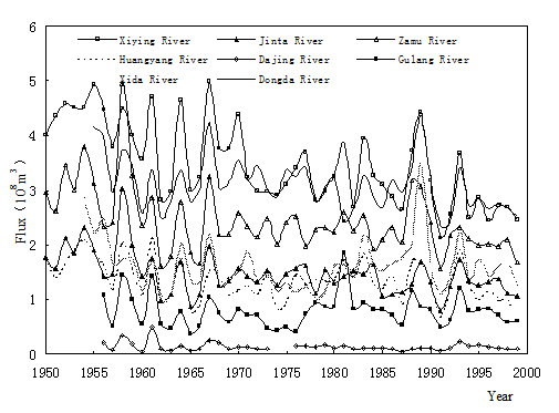
Fig.1 The runoff curves of bigger rivers

Fig.2 The runoff
curves of the Shiyang River and the
When flowing out of the mountains, rivers flow into the South Basin of Hexi Corridor like broom, and then, in the Gobi zone with high permeability, surface water all recharge groundwater, and at the foot of the diluvium-alluvium fan, groundwater discharges to Shiyang River and Jinchuangxia River in the form of springs, and finally, the two rivers flow into Minqin County and Hexipu of Jinchuang and disappeared through the irrigation and evaporation.
In history, flood that comes from the upriver mountain
area could flow straight to Shiyang River and then runs into the end lakes, namely, the Qingtu Lake
and the
2.2 Groundwater
In 2000, the total recharge of groundwater in study area
was 1,092 million m3, and the natural recharge resource was 546
million m3, among which 422 million m3 was in the Wuwei
Basin and there the modulus was 453 thousand m3/(a·km2); 24 million m3 was
in the Minqin Basin and there the modulus was 186 thousand m3/(a·km2). The exploitable resource of
groundwater was 725 million m3/a, among which 328 million m3/a
was in the Wuwei Basin,
351 million m3/a was in the Minqin
Basin and 46 million m3/a
was in the
3 Current Status of groundwater Resources Exploitation
Before 1970s, surface water was mainly utilized, but the
simple use of surface water led to results that the groundwater level was
very shallow, the soil was salted and the water quality was deteriorated.
Since founding that groundwater level decline could control the soil
salinization effectively in 1980s, groundwater has been exploited and utilized
both in a great quantity, and the vast of salted land has become cultivated
fields. Currently, because the utilization degree is very high, it is very
difficult to exploit surface water again. The utilization degrees of
groundwater all have exceeded 100% and the total exploitation is far more than
recharge, so the groundwater level has declined in the region successively,
especially it has declined the most greatly in Wuwei
City and
By 2000, there were 14,852 pumping wells and the mean
density was 2.16 wells/km2. 5,015 wells in the Wuwei
Basin and the mean density 1.49
wells/km2; 8,122 wells in the Minqin
Basin and the mean density 3.68
wells/km2; 1,715 wells in the
In the same year, the total use of water was 2,399
million m3, among which surface water accounted for 38% and
groundwater accounted for 62%. The use of water in the
Comparing the pumping yield with exploitable resource, we can find that 766 million m3/a of groundwater has been overexploited. In the Wuwei Basin 405 million m3/a of groundwater has been overexploited and its exploitation degree is 223.51%, in the Minqin Basin 220 million m3/a of groundwater overexploited and its exploitation degree 162.55%, and in the Chuangning Basin 141 million m3/a of groundwater overexploited and its exploitation degree 409.10% (Table 1).
Table 1 The utilization of groundwater in the Plain of Shiyang River Basin
|
Region |
Natural recharge (Million m3/a) |
Exploitable resource (Million m3/a) |
Pumping yield (Million m3/a) |
Over-exploitation volume (Million m3/a) |
Exploitation degree (%) |
|
|
422 |
328 |
733 |
405 |
223.51 |
|
|
100 |
351 |
571 |
220 |
162.55 |
|
|
24 |
46 |
187 |
141 |
409.10 |
|
Total |
546 |
725 |
1,491 |
766 |
- |
4 Existing Problems of Groundwater Resources Utilization
Although the problems in the study area have been researched again and again for many years, many scholars, such as Chen Mengxiong (2002) et al., have indicated these problems of water resources utilization and have brought forward many valuable treatment and management ways, yet in the actual process of groundwater utilization, the mode and tactic of water resources utilization haven't largely changed, and there still exist main problems as follows:
As strengthening of human
being's activity, the artificial surface water system has replaced the natural
system gradually, and the surface water system has been changed largely. Since
1957, different-sized reservoirs have been built at the upward reaches of all
rivers, almost controlling the coming water from the mountain area. The
Hongyashan Reservoir has been built in the middle reaches of the Shiyang River,
and becomes only supplied source of the
In recent 50 years, the groundwater recharge of study area has reduced markedly. The groundwater resources were 1,587 million m3/a in 1950s, 1,201 million m3/a in 1960s, 977 million m3/a in 1970s, 925 million m3/a in 1980s and 617 million m3 in 2000. Compared with that in 1950s, the groundwater resources have been decreased by 970 million m3/a in 2000, and the reduction ratio is 61%. With the successively increase of the economic and social needs year by year, the pumping yield of groundwater has becoming larger and larger, and groundwater resources have been overexploited seriously. In 1995, the total water need was 2,044 million m3 and the pumping yield was 1,116 million m3; and in 2000, the figures were 2,399 million m3 and 1,491 million m3 respectively.
The relationship between the spring flux and the groundwater level is very close, and they have the same dynamic process. As surface water has been imported for irrigation and groundwater exploited in the Wuwei Irrigation area, the groundwater level has declined and the spring flux has reduced, the springs have disappeared and the overflow zone has moved to the downriver area. For example, the spring 549, since 1986, its flux decreased about 1/3 and the groundwater level in the period of 1986-1988 was one meter lower than that seven years ago (Fig.3). According to the recent dynamic monitoring data, the groundwater level has declined successively with the speed of 0.5-0.9 m per year, and the burial depth of groundwater level in the old overflow zone has increased to more than ten meters. Springs have almost disappeared, the proportion of the overflow zone has decreased, and the incoming water of Hongyashan Reservoir has reduced rapidly. Therefore, the contradiction of water utilization between the upriver area and the downriver area is very outstanding, and the status has been formed that the upriver area occupies the water used for the downriver area and the downriver area occupies the water used for eco-environment.

Fig.3 Relationships between the spring flux and the groundwater level
The Hongyashan
Reservoir is an important source of groundwater in the
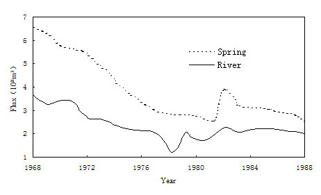
Fig.4 The flux Relationships between spring and the Shiyang River measured at the Xiangjiawan observation station(①The Second Hydrogeology and Engineering Geology Team of Gansu Bureau of Geology Exploration, et al. 1991. Study on the Management Modeling of Water Resources in the Plain of Shiyang River Basin of Gansu Province (in Chinese). Internal report, 29.)
Further, as the intensively pumping of groundwater, in the center zone where groundwater was pumped more, the TDS reported has increased rapidly, and the depravation of groundwater quality has been very distinct. The quality of groundwater environment has been relatively wicked. The groundwater was polluted to the serious degree in most regions, and especially, in the northern basin, the groundwater quality was depraved rapidly, belonging to the polluted zone of serious degree. It not only is undrinkable, but also is very dangerous for irrigation (Li Youlin, 2000). Hence, the environment problems, such as the desertification of land, the degradation of vegetation and so on, have become serious day by day. In the lake area of Minqin County, the irrigated oasis has decreased about 10 thousand hm2, the desert vegetation is becoming less and less, the meadow vegetation has died to a large extent, the man-planted woods has died in the downriver area etc. According to the statistical data, near the Minqin oasis, there have been 2,800 hm2 of Calligonum (about 21,520 thousand trees) died completely, and 5,800 hm2 of Calligonum (about 7,000 thousand trees) have fallen off, accounting for 9% and 21% of the total area (Wang Qi et al., 2003).
5 Suggestions for Reasonable Utilization of Groundwater Resources
The
(1) Because the utilization degree of surface water has been reached the
maximum value and the groundwater has been over-exploited seriously, on the one
hand, we should reduce the water consume for the production value of 10
thousand yuan RMB by adjusting the industrial structure. And on the
other hand, we should save the water in agriculture actively to reduce the
irrigation ratio. Due to water resources have been wasted very seriously in
study area, it is very potential to save water in agriculture. For example, the
irrigation ratio was 18,000 m3/hm2 in Minqin
Basin and 9,750 m3/hm2 in
(2) We should understand the advantages and disadvantages of reservoirs fully. The advantageous aspect is in favor of the artificial control and management, consequently to establish the highly efficient irrigation system to benefit the water resources utilization. The disadvantageous aspect is that evaporation is very huge, the recharge of groundwater will be reduced and the eco-environment will be depraved. Hence, when the water use of city, industry and living could be ensured, we should to release water from reservoirs to recharge groundwater and to maintain the eco-environmental development.
(3) Based on the principle to plan the water resources utilization and
management in the whole river basin, we should control the well building and
the groundwater exploitation to ensure the water need of the
(4) The research on the relationships between the evolution of eco-environment and the utilization of water resources, especially the eco-environmental sense study of soil water and coagulated water, should be carried out to bring forward the eco-environmental water requirement and the eco-environmental carrying capacity so as to satisfy the eco-environmental need firstly to remain the sustainable development of it.
(5) To implement the national policy that woods and grass are encouraged to plant instead of farming, to enlarge the area to resist the wind and the desertification. On one hand, we should reduce irrigation water; on the other hand, we should decrease the useless evaporation of water resources to enrich groundwater, consequently to improve the eco-environment.
References
[1]
Li Youlin. 2000. The Hydro-environment Problems of
Groundwater in
[2]
Chen Mengxiong, Ma Fengshan. 2002. Groundwater Resources
and Environment in
[3]
Wang Qi, Shi Ji-an, Zhang Zhongning, et al. 2003.
Current Situation of the Environment in
[4] Guo Zhanrong, Liu Huatai, Zhu Yanhua. 2001. Study on exploitation and protection of groundwater in Northwestern China[J]. Jounral of hydraulics, (6): 37-40 (in Chinese with English abstract).