


Achievements
THE EVALUATION METHOD AND RESULT ANALYSIS FOR THE GROUNDWATER RESOURCES AND ITS MINABLE VOLUME IN XINJIANG
Dong Xin-guang**, Zhong Rui-sen, Liu Feng, Zhou Jin-long, Wang Shui-xian
(School of Water Conservancy and Civil Engineering,
Xinjiang Agricultural University,
E-mail: xinguangdong@163.com
Abstract: This paper described, according to the fundamental requirements listed in “Nationwide Comprehensive Water Resources Planning” for the survey and evaluation of groundwater resources, combined with the geology, hydrogeology, hydrometeorology, agriculture and ecological environment, and the characteristics of formation and conversion of water resources in the arid and semiarid regions of Xinjiang, by introducing “3S” and computer technologies and integration of water resources system with the concepts and approaches in soil science, agricultural and environmental sciences, and other relevant subjects, a systematic approach established for evaluation of groundwater resources and minable volume specially for arid region, and systematically introduced, through the evaluation of water resources evaluation in the plain area in Xinjiang, a complete set of evaluation approaches for the subdivision of water resources, assessment of water quantity & quality, selection of parameter, calculation of water balance, analysis of minable volume and mining potential, etc. which already been computerized programming.
The major approaches for evaluation include:1)by integration and application of GPS, RS, and GIS for water resources subdivision, via GPS calibrated image for precisely positioning of test wells and exploration wells, vegetation distribution interpreted from remote sensing, and GIS comprehensive processing and topographical analysis, the areas for various types of subdivision have been obtained. 2)based on systematical summary of the historical results for comprehensive evaluation of groundwater resources, some critical parameters were on-site tested and supplemented and the hydrogeology parameters were synthetically analyzed. 2)by using the equilibrium method for evaluation of groundwater resources, integrative combination of basic data, parameters, areas, and other related spread sheets were automatically running on VBA software programmed by Microsoft Office Excel application; 4)took typical area as example for cross reference and calibration by application of equilibrium method and numerical modeling for groundwater, the groundwater resources and minable volume were evaluated, and hereby the correspondent evaluation approach for minable volume and mining potential of groundwater was proposed accordingly.
The main results include: 1)the total calculated area for groundwater resources in Xinjiang is 120.82×10⁴km2, among which 69.91×10⁴km2 in the mountain area and 50.91×10⁴km2 in the plain area. The generation and consumption of groundwater in the plain area are mainly taken place in the irrigated areas covered 7.93×10⁴km2 in area. 2)the perennially averaged total annual recharge of groundwater in the plain area is 336.6×10⁸m3, discharge 340.5×10⁸m3, the annual averaged reserves variation -10.49×10⁸m3. 3)the irrigated area accounts for 15.5% of the plain area, whereas the total groundwater recharge there accounts for 82% of that in the plain area. The area with groundwater TDS less than 2g/l in the irrigated area takes account 96.2% of the total area. 4)the groundwater recharge in the plain area is mainly supplied by the seepage in the irrigated area(canal system and farmland), and following by river seepage and natural supplement, accounting for 50.1%, 36.3%, and 13.6% of the total recharge respectively. The converted recharge in the plain area accounts 86.4% of the total, the discharge is mainly by phreatic evaporation, accounting for 53.3%a of the total discharge, and the currently mined groundwater volume is 56×108m3/a; 5)the minable groundwater in the near and medium future in the plain area is estimated 153×108m3/a, the increasable groundwater mining potential in the near future 66×108m3/a.
Key words: Xinjiang, Groundwater, Subdivision, 3S Technology, Minable Volume
In the long geological history, Xinjiang went through Caledonian, Varisian and Himalayan orogenic movements, during which the folded belts formed mountainous areas and the subsidence zones formed the basins. The major morphological features of Xinjing resulted from the abovementioned tectonic movements is ‘two basins sandwiched in three mountains’, where the three mountains are Tianshan Mountain in the middle of Xinjiang, Altay Mountain at the northern border of Xinjiang, and Kunlun Mountain at the southern edge of the region, and the two basins refers to Tarim Basin in between Tianshan and Kunlun mountains and Jungar Basin in between Tianshan and Altay mountains.
Xinjiang is located in the central part of the Euro-Asian continent, so closed and far away from the oceans that it is difficult for moister from the Arctic Ocean and Mediterranean Sea to reach the region. Due to the topographic and morphologic feature of ‘two basins sandwiched in three mountains’, precipitation in the mountainous areas is relatively plenty, forming surface rivers that are all centroclinal and flow towards the basin. In the process of flowing towards the basin, the surface rivers run through various petrographic facies, morphologic zones and, through transformation and replenishment, formed groundwater systems with various hydraulic features, i.e., phreatic aquifer system-phreatic and confined aquifer system-confined aquifer system. Precipitation in the plain area is little while evaporation strong, frequent transformation of surface water and underground water from one to another occurs in the plain area, and water is consumed up through
evapo-transpiration in various forms and disappears into the air.
In line with the basic requirements in the Guidelines for Water Resources Assessment, Technical Specifications for Nationwide Comprehensive Planning for Groundwater Resources and Additional Specifications for Nationwide Assessment of Groundwater Resources and the Exploitable Amount, and based on the characteristics of the arid and semi-arid areas of Xinjiang, a systematic assessment of groundwater resources and the exploitable amount has been conducted, based on which the assessment approach for groundwater resources and its exploitable amount in arid and semi-arid inland areas has been summarized, the results of assessment are of guiding importance to sustainable development of water resources in Xinjiang.
1 Survey of Groundwater Resources and Analysis of the Results
In conducting this assessment, collection and compilation of and references to data and research results[1] obtained previously ever since 1949 was followed by a Xinjiang region wide additional hydro-geological survey of the plain areas using working maps with scale of 1:1,000,000. The surveyed area is 509112km2 and investigated wells are 1069 in total number, observation wells are 424 in total, while canal seepage tests were conducted for 37 sections and field infiltration experiments were performed in 22 sites. Also in the process of assessment, interpretation of land images with scale of 1: 100,000 and topographical analysis of professional maps are conducted and 14 sets of professional maps with scale of 1:1,000,000 and several hundreds of calculation tables[2] are produced.
The main results from investigation are: shallow groundwater depth and the corresponding areas in the plain area in Xinjiang, including irrigated area and non-irrigated areas(Tab. 1), and area of various unsaturated strata (Tab. 2), and areas of groundwater mineral concentration distribution (Tab. 3).
Tab. 1 Shallow Groundwater Depth and Corresponding Areas in Plain Areas of Xinjiang Unit:km2
|
Zones |
Groundwater Depth | |||||||
|
≤1m |
1~3m |
3~6m |
6~10m |
10~30m |
>30m |
Subtotal | ||
|
Irrigated Areas |
Eastern Xinjiang |
114 |
660 |
625 |
1245 |
352 |
2997 | |
|
|
419 |
15036 |
10237 |
3131 |
4519 |
1834 |
35176 | |
|
|
76 |
3342 |
5276 |
5235 |
9441 |
6588 |
29957 | |
|
Other River Basins |
111 |
3524 |
1634 |
1715 |
2417 |
1728 |
11129 | |
|
Sub-total |
607 |
22016 |
17807 |
10706 |
17622 |
10501 |
79259 | |
|
Non-irrigated Areas |
Eastern Xinjiang |
1446 |
4289 |
3470 |
63367 |
4185 |
76757 | |
|
|
360 |
36500 |
57043 |
100067 |
29591 |
42653 |
266214 | |
|
|
3091 |
11798 |
9012 |
18626 |
8347 |
50874 | ||
|
Other River Basins |
294 |
10456 |
19497 |
3040 |
2120 |
662 |
36068 | |
|
Sub-total |
654 |
51493 |
92626 |
115589 |
113704 |
55846 |
429913 | |
Tab. 2 Areas of Various Unsaturated Strata in the Plain Area in Xinjiang Unit:km2
|
Zones |
Areas of Various Strata | ||||
|
Sandy Gravel |
Fine Sand |
Sub-sandy Soil |
Sub-clay |
Subtotal | |
|
Eastern Xinjiang |
66661 |
10587 |
261 |
2244 |
79754 |
|
|
61018 |
211980 |
23910 |
4482 |
301390 |
|
|
23113 |
22613 |
24245 |
10860 |
80831 |
|
Other River Basins |
22930 |
20540 |
2947 |
779 |
47197 |
|
Sub-total |
173723 |
265721 |
51364 |
18365 |
509172 |
Tab. 3 Areas of Mineral
Concentration Distribution of Shallow Groundwater
Water
in the Plain Area of Xinjiang Unit:km2
|
Zones |
Areas with Various Mineral Concentration(g/l) | ||||||
|
M≤1 |
1<M≤2 |
2<M≤3 |
3<M≤5 |
M>5 |
Total | ||
|
Irrigated Areas |
Eastern Xinjiang |
2645 |
310 |
25 |
15 |
2997 | |
|
|
20308 |
12132 |
2133 |
555 |
49 |
35176 | |
|
|
29646 |
286 |
25 |
29957 | |||
|
Other River Basins |
10692 |
318 |
78 |
23 |
18 |
11129 | |
|
Sub-total |
63292 |
13045 |
2262 |
593 |
67 |
79259 | |
|
Non-irrigated Areas |
Eastern Xinjiang |
65175 |
10249 |
405 |
928 |
76757 | |
|
|
85802 |
91005 |
46143 |
42741 |
522 |
266214 | |
|
|
50580 |
241 |
54 |
50874 | |||
|
Other River Basins |
34331 |
1698 |
36 |
3 |
1 |
36068 | |
|
Sub-total |
235888 |
103193 |
46637 |
43672 |
523 |
429913 | |
Irrigated areas are the major place where surface water from canals, field, river channels, reservoirs and return water from well irrigation area infiltrate and recharge groundwater. In the calculated plain area of 50.91×10⁴km2, only 7.93×10⁴km2 out of the irrigated area has groundwater table deeper than that in the non-irrigated area, and groundwater quality in the irrigated areas is better than that in the non-irrigated area, indicating cycling of local surface water and groundwater.
Distribution of various natural ecological vegetations in the non-irrigated area was analyzed to find out their water consumption mechanism and amount of water consumption, so as to arrive at more accurate results of groundwater resources in the river basins. Hence, zoning of natural ecological vegetation in the non-irrigated areas in line with land use categories was performed (for results, refer to Tab. 4)
Tab. 4 Areas of Forest, Grassland in the Non-irrigated Area in the Plain Areas in Xinjiang Unit:km2
|
Zones |
Areas of Various | ||||||||
|
Bare Land |
Land with Forest |
Bushes |
Sparse Forest |
Other |
Grass with High-coverage ratio |
Grass with Medium-coverage ratio |
Grass with Low-coverage ratio |
Total | |
|
Eastern Xinjiang |
68253 |
42 |
103 |
68 |
62 |
435 |
1376 |
6418 |
76757 |
|
|
184772 |
1472 |
4133 |
3205 |
86 |
6931 |
16459 |
49156 |
266214 |
|
|
29892 |
426 |
627 |
319 |
23 |
1288 |
3766 |
14533 |
50874 |
|
Other River Basins |
22588 |
678 |
447 |
286 |
22 |
1715 |
3049 |
7283 |
36068 |
|
Sub-total |
305505 |
2618 |
5310 |
3878 |
193 |
10369 |
24650 |
77390 |
429913 |
2 Zoning Method for and Results from Groundwater Resources Assessment
In line with principle of integrated zoning for water resources in the river basins, zoning for groundwater resources calculation was done on the basis of the local geological and hydro-geological conditions, features of water resources formation, transformation, transportation, storage and water chemical characteristics in Xinjiang by using electronic maps with scale of 1:250,000 and results from hydro-geological survey based on maps with scale of 1:1,000,000. Land uses and vegetation coverage were analyzed by interpreting satellite images with scale of 1:100,000.
2.1 Calculation zones
Zones for water resources calculation include
administrative zones, river basin zones and calculation zones formed by
combining river basin zones with administrative zones. There are 15 prefecture
level administrative zones in Xinjiang. River basin zones in Xinjiang include 2
level-1 zones, 12 level-2 zones and 26 level-3 zones. The 57 calculation zones
formed by combining river basin zones with administrative zones are the basic
statistical units for groundwater resources survey and data compilation of the
assessment. The total area of Xinjiang is 164.37×10⁴km2, including mountainous
and hilly areas of 70.13×10⁴km2,
plain area of 94.24×10⁴km2.
The total calculation area of groundwater resources in Xinjiang is 120.82×10⁴km2, including
mountainous and hilly areas of 69.91×10⁴km2, plain area of 50.91×10⁴km2. In the plain
area the three deserts, namely Guerbantongut
Desert, Taklamagan
Desert and
2.2 Groundwater type zones
Three groundwater types are used to divide groundwater zones, such as:
Level-1 Groundwater Type Zone: According to topographic and morphological features in the local areas, groundwater resources assessment area is divided into 2 level-1 groundwater areas, i.e. plain area and mountainous area.
Level-2 Groundwater Type Zone: According to the
topographic and morphological sub-features and groundwater types n the level-1
groundwater type zones, the plain area is then divided into 3 types, including
inter-mountain plain, inland basin plain and desert zones. The inter-mountain
zones refer to Tu-Ha Intermountain Basin,
Ta-E Intermountain
Basin, Yili Intermountain Vally, Yanji Intermountain
Basin,
Level-3 Groundwater Type Zone: According to hydrological and hydro-geological conditions, the level-2 type zones are further divided into some balancing areas for calculation.
Within the level-2 type zones in the plain areas, by using topological zoning level-3 type zones are formed, such as sub-zones of unsaturated strata, groundwater depth, irrigation areas, non-irrigation areas, natural ecological vegetation and mineral concentration. The level-3 groundwater type zones are the smallest units for selection of hydrological and hydro-geological parameters and for calculation of groundwater recharges, discharges, storage variation and the amount of groundwater resources.
Based on level-3 zones, totally 95068 calculation units are built in line with level-3 water resources zones integrated with county/city level administrative zones, including 434 calculation zones in the mountainous areas, and 94634 calculation zones in the plain areas. The total groundwater resources of Xinjiang is obtained by aggregating calculation results of the level-3 water resources zones that are integrated with the county/city level administrative zones. Through balancing analysis and verification of the replenishment and discharge in the level-3 water resources zones, assessment results of groundwater resources for the water resources zones and administrative zones are gained. Fig. 1 illustrates relationship among various zones.

Fig. 1 Relationship among Various Zones in Groundwater Resources Assessment in Xinjiang
3 Groundwater Resources Assessment Method Based on Water Balancing and 3S Techniques
A complete groundwater calculation and assessment software system is developed based on water balancing theory and by using 3S techniques to divide the zones, categorize the areas, process the calculation results and connect to database of attributes, using Microsoft Office Excel’s strong spread sheet management and processing capabilities and the powerful programming capacity of VBA (Visual Basic for Application, installed in Microsoft Office Excel) to conduct automatic calculation, so that programmed calculation, establishment of database for basic data and parameters, vectorization of maps, images and professional maps are realized. Such a system has upgraded accuracy and is capable to give a rapid display of tables of results for groundwater recharge and discharge calculation and various gourndwater module maps. The procedures and processes of the assessment are shown in Fig. 2[2, 3].
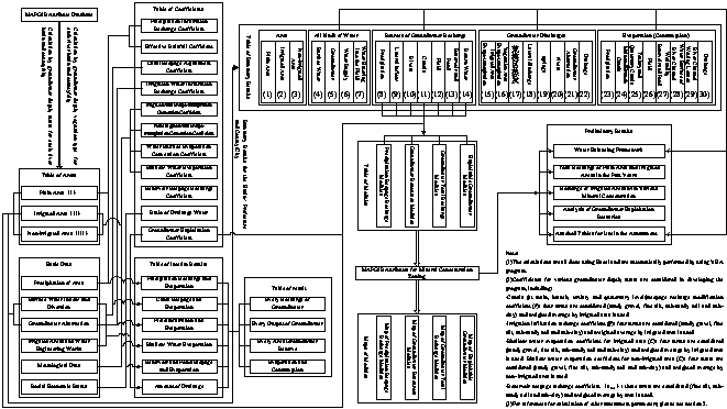
Fig. 2 Framework of Groundwater Resources Calculation and Assessment Based on Water Balancing and 3S Techniques
4 Main Results from the Groundwater Resources Assessment
4.1 Selection of hydro-geological
parameters
This time the assessment of groundwater resources involves mainly the following hydrological and hydro-geological parameters: precipitation infiltration recharge coefficient (α), river channel seepage recharge coefficient (M), canal water use efficiency coefficient (η), canal seepage recharge coefficient (m), canal seepage recharge modification coefficient (γ), canal seepage modification coefficient (γ1), canal lining modification coefficient (γ2), irrigation infiltration recharge coefficient (β), plain reservoir seepage recharge coefficient (αres.), shallow water evaporation coefficient (C), shallow water evaporation plant status modification coefficient(k), storativity of shallow water changeable aquifer(μ)、transmission coefficient (K), and water surface evaporation coefficient etc[4].
The hydrological and hydro-geological parameters used in this assessment are based on systematical summary and absorption of previous results of groundwater resources, additional experiments and researches for additional key parameters had been conducted. The previous results include experimental results from Changji, Wulabo, Qunke, Turpan, Sangonghe river basins, and groundwater balancing experimental results from Shacha county, data of recently conducted geological explorations and wellfield explorations[5, 6]. Irrigation infiltration and canal seepage experiments were performed in the field. For areas lacking groundwater dynamic monitoring data or experimental data, references to other areas with similar hydrological and hydro-geological conditions were used.
4.2 Assessment of groundwater amount
Groundwater resources in the plain area: using the above-mentioned calculation and assessment methods and hydro-geological parameters, groundwater resources of the river basins, prefectures and counties/cities of Xinjiang were calculated. The results obtained include various recharges in five years(1980, 1985, 1990, 1995, 2000)and at long term average level for the three river basins, prefectures, and counties/cities. The total average groundwater recharge in Xinjiang is 336.6×10⁸m3,including precipitation infiltration recharge of 13.2×10⁸m3, lateral recharge in front of the mountains of 31.9×10⁸m3, river channel seepage recharge of 123.6×10⁸m3 , canal seepage recharge of 100.1×10⁸m3, canal irrigation field infiltration recharge of 53.6×10⁸m3, reservoir and pond seepage recharge of 8.8×10⁸m3, and well irrigation return recharge of 5.5×10⁸m3. The long term average discharge is 340.5×10⁸m3, including shallow water evaporation of 180.8×10⁸m3, actual groundwater exploitation of 39.8×10⁸m3, plain spring water of 53.9×10⁸m3, discharge from drainage canals of 34.0×10⁸m3, lateral discharge of 7.3×10⁸m3, river discharge of 24.6×10⁸m3. The long term average annual groundwater storage variation is -10.49×10⁸m3. The relative error is 1.85%.
Total recharge in the irrigated plain areas: The irrigated area takes up 15.5% of the total plain area in Xinjiang, but the long term average groundwater charge in the irrigated area is 278.1×10⁸m3/a, accounting for 82% of the total in the plain area. Normally, in the small river basins, total recharge in the irrigated areas is not much different from the total in the plain area, but the difference is relatively big in the large river basins. Included in the irrigated plain areas, an area of 6.3×10⁴km2 having groundwater mineral concentration less than 1g/l and long term average recharge of 212.3×10⁸m3/a , an area of 7.6×10⁴km2having mineral concentration less than 2g/l, accounting for 96.2% of the total irrigated area, and the long term average recharge is 266.1×10⁸m3/a, accounting for 95.6% of the total recharge in the irrigated area, all of which indicating that the overall quality of groundwater in the irrigated plain area in Xinjiang is good.
Assessment of groundwater resources in the mountainous and hilly areas uses discharging amount method, i.e. the recharge amount is derived from discharge amount. The calculation results of the total groundwater resources are shown in Tab. 5.
Tab. 5 Long Term Average Groundwater Resources in Xinjiang Unit:area/km2,water volume/108m3
|
Zones |
Mountainous Area(M≤2g/L) |
Plain Area(M≤2g/L) |
Ground water Res. |
Repeated amount betw. Surface and Gr.water | |||||||||
|
Calc. area |
River channel base flow |
Pediment lateral discharge |
Ground water Res. |
Calc. area |
Recharge from Precipi. Infiltr. |
Pediment lateral recharge |
Recharge from surface water |
Rechar. From well irrigation return |
Total Rechar |
Ground water Res. | |||
|
Eastern Xinjiang |
5.37 |
7.76 |
3.75 |
11.51 |
7.83 |
0.46 |
3.70 |
9.01 |
1.51 |
14.69 |
13.17 |
17.45 |
4.21 |
|
|
8.77 |
42.38 |
7.81 |
50.19 |
8.08 |
3.39 |
7.75 |
39.56 |
2.44 |
53.14 |
50.70 |
78.41 |
11.19 |
|
|
44.52 |
147.43 |
17.13 |
164.56 |
20.93 |
4.18 |
15.94 |
172.57 |
1.14 |
193.84 |
192.70 |
275.60 |
21.25 |
|
Other River Basins |
9.06 |
96.18 |
3.59 |
99.77 |
4.70 |
5.54 |
3.53 |
39.30 |
0.18 |
48.54 |
48.37 |
129.81 |
6.76 |
|
Sub-total |
67.72 |
293.75 |
32.28 |
326.03 |
41.54 |
13.57 |
30.92 |
260.44 |
5.27 |
310.21 |
304.94 |
501.27 |
43.41 |
4.3 Quality assessment of groundwater resources
Quality assessment of groundwater resources involves 7 items, such as PH, Mineral Concentration, TDS(expressed in equivalent of CaCO3), NH4-N, volatile phenol(in phenyl), CODMn and colon bacillus. The standard for the quality assessment is 《GB/T14848-93 Quality Standard for Groundwater》. Single indicator evaluation method (referring only to the worst indicator among all to evaluate) is used to determine categories of groundwater quality.
Groundwater quality of the exploitable aquifers in
the plain areas is mainly of Class-3 type, seconded by Class-4 and Class-5,
with few of Class-1 or Class-2. Groundwater of Class-3 takes up 50.8% of the
total calculation area (see Tab. 6). Yili
River and
Tab. 6 Ratio of Groundwater of Various Quality to the Total Groundwater Amount
|
Zones |
Ratio of Groundwater of Various Quality to the Total Groundwater Amount (%) | |||||
|
Ⅰ |
Ⅱ |
Ⅲ |
Ⅳ |
Ⅴ |
Subtotal | |
|
Eastern Xinjiang |
9.11 |
20.30 |
50.44 |
12.36 |
7.80 |
100 |
|
|
0.45 |
6.25 |
49.85 |
9.35 |
34.11 |
100 |
|
|
11.33 |
28.00 |
48.26 |
10.41 |
2.00 |
100 |
|
Other River Basins |
0.02 |
23.06 |
68.50 |
2.09 |
6.32 |
100 |
|
Sub-total |
2.38 |
12.73 |
52.52 |
8.50 |
23.87 |
100 |
5 Water Balancing Analysis of the River Basins
Water balancing analysis is for test and verification of recharges and discharges of groundwater. In this assessment, river basins were used as the basic units for water balancing analysis. Water balancing theory for the river basins: Total inflow to the river basin- Total outflow from the river basin ± storage variation = Total water consumption.
As shown in Framework for Long Term Average Water Balancing Analysis of Xinjiang (Fig. 3 ): ① Recharge to groundwater comes mainly from infiltration of the irrigated areas(canal systems and farm land), second to which are river channel seepage and natural recharge, accounting for 50.1%、36.3% and 13.6% respectively of the total recharge, the transformation recharge in the plain area takes up 86.4% of the total recharge. ② Discharge of groundwater is mainly by shallow evaporation, taking up 53.3% of the total discharge, while spring spillover taking up 15.8%, groundwater exploitation taking up 11.6%, drainage from drainage canals merely 10.0%, groundwater return to river channel 7.2% and lateral discharge 2.1%. ③ Total water consumption is 651.5×10⁸m3/a. and total outflow from the river basins is 244.9×10⁸m3/a; evapo-transpiration from farm and forest is 190.1×10⁸m3/a, accounting for 22.4% of the total surface water inflow in the river basins. ④ Evaporation from river channels, canals and their surrounding wetted soil accounts for respectively 9.9% and 9.9% of the surface water inflow, water consumption of reservoirs, lakes and wetlands amounts to 10.7% of the total surface water consumption. ⑤ Drainage by drainage canals amounts to 8.5% of the total water diversion into the irrigated areas. ⑥ Water balancing analysis reflects the relation of water formation, transformation and consumption in the river basins. For instances, in Tarim River Basin, the shallow water evaporation accounts for 31.4% of the total surface inflow, indicating the co-existence of water shortage and low water use efficiency and water-saving together with use of groundwater as effective measures to improve water use efficiency there; in the middle part of northern Tianshan pediment areas, the total water consumption is 60.5×10⁸m3/a, exceeding the total inflow into the river basin ( 57.4×10⁸m3/a), and groundwater over-exploitation there is about 4.4×10⁸m3/a, indicating that control over groundwater use and strengthening farm water-saving can be the major measures to be taken. ⑦ Shallow water evaporation of Xinjiang is 180.8×10⁸m3/a, including non-beneficial shallow water evaporation of 53.4×10⁸m3/a. Analyses of water resources transformation and balancing indicate that groundwater utilization is the effective approach to lower groundwater table and capture shallow water evaporation, and water availability can be increased by capturing non-beneficial evaporation.
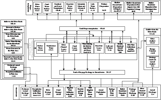
(Note:Unused river water in Qiantang Plateau, Qipuqiapo Small Rivers, Caidamu Basin is not taken into calculation.)
Fig. 3 Framework for Long Term Average Water Balancing Analysis of Xinjiang,
6 Assessment of Groundwater Resources and the Exploitable Amount in the Typical River Basins
Assessment of groundwater resources and the exploitable
groundwater starts with 2 typical river basins in Xinjiang, one is the Sangonghe River Basin
in the pediment area of northern Tianshan mountain and another is the
Main results for Sangonghe River Basin from water balancing analysis and groundwater numerical model calculation: ① According to results from the two methods, over-abstraction of groundwater in the Sangonghe River Basin is about 1000×104m3/a and the exploitable groundwater in the river basin is 3800×104m3/a. ② For the river basin, exploitable groundwater= stable (pediment) lateral recharge + Min [ (17% of the total surface diversion in the river basin, 38% of transformation recharge of the river basin ] or 59% of the total recharge in the river basin. The conclusion is suitable to areas in the northern Tianshan areas where water use efficiency is relatively high ( canal water use efficiencyη≥65%, comprehensive water use efficiency ≥55%). ③ For the fine soil plain area at the downstream of the river basin, recharge to groundwater comes mainly from irrigation water transformation. Results from 30-year groundwater dynamic analysis and from 16-year water balancing and numerical simulation tell that exploitable groundwater needs to be controlled at within 23%~25% of the total water diversion into the irrigated areas, or at 36% of the transformation recharge of the assessment area. If using such amount of groundwater, groundwater table can be under control and soil salinity can be prevented, while water use efficiency upgraded without adverse impacts on the eco-environment surrounding or within the irrigated areas.
Considering upgrading of water use efficiency in
7 Analysis of Exploitable Groundwater and Exploitation Potential
Several principles in defining the exploitable groundwater: (1) The basis for defining the exploitable groundwater is the total recharge to groundwater in irrigated areas with mineral concentration within 2g/l; (2) Full consideration needs to be given to the situation that with completion of water engineering structures and improvement of water use efficiency, groundwater table will be lowered and recharge to groundwater will decrease; (3) Ample thinking of the relationship amongst eco-environmental protection, effective groundwater utilization and exploitable groundwater is needed; (4) Carefully study the exploitable groundwater in the typical river basins and consider the various features of the river basins to be assessed, define based on analyses from various perspectives the groundwater exploitable coefficient, and, based on all of the above work, define the exploitable groundwater for the river basins; (5) Considering the gradual completion of water engineering works in Xinjiang, the slowness in reduction of transformation recharge to groundwater, the seriousness of soil salinity in some of the river basins, and the three functions (increasing water supply, reducing salinity, regulating water) of groundwater development and utilization in Xinjiang, it is necessary to increase the degree of groundwater exploitation in some suitable areas. Along with upgrading of water engineering structure, groundwater exploitation needs to be reduced gradually and its functions in increasing water and reducing salinity will tends to be stable and its regulating function will increase gradually.
In defining exploitable groundwater in the river
basins in Xinjiang, it is feasible to use the groundwater exploitation
coefficient and base the analysis on a macro scale. However, in many areas it
is currently still quite difficult to develop groundwater resources, and water
resources in some river basins are now relatively abundant to the current
economic development. Due to reasons like mentioned above, groundwater
exploitation will not reach the exploitable amount in the near or medium terms.
Therefore, the calculation principles for groundwater exploitable potential in
Xinjiang are: (1) Groundwater over-abstraction areas in the three levels of
water resources zones will not have exploitable groundwater amount; (2) In
areas where water resources are rich but surface water use efficiency is low,
development and utilization of surface water will be proposed for the short
term and groundwater development is only for industrial, domestic, garden
purposes, thus it is impossible to realize the exploitable groundwater obtained
based on groundwater exploitable coefficient; (3) In areas where groundwater
table is deep and recharge is scattered (such as Keliya Small Rivers, Cherchen
River Basin), groundwater exploitation will be rather difficult and the potential
for groundwater use in the near and medium terms is small; (4) The exploitable
groundwater defined in this assessment gives adequate consideration of the
recharges and discharges, but consideration over the groundwater development
conditions (such as unit yield, pumping cost, construction investment, etc)
seems not enough yet. For instance, groundwater development conditions are poor
in the mainstream
8 Conclusions
(1) By paying close attention to features of the arid and semi-arid areas in Xinjiang, introducing advanced techniques and method and following principles for integrated water resources assessment, analyses of water resources zoning, water balancing, typical areas, exploitable groundwater and the potential of groundwater uses were conducted together with a systematic research on assessment method of groundwater resources and the exploitable amount in arid areas. The results developed under the analyses have been widely applied in the groundwater assessment practices for the river basins and prefectures, counties/cities in Xinjiang, and good effects have been achieved.
(2) The long term average total recharge to groundwater in Xinjiang is 336.6×10⁸m3/a and the total discharge is 340.5×10⁸m3/a. The obtained long term average total recharge to groundwater of this time is 33.4×10⁸m3/a less than that obtained in assessment of 1980, and is 58.4×10⁸m3/a less than that in assessment of 1988. Total recharge to groundwater with mineral concentration of less than 2g/l (≤2g/L) in the irrigated plain areas is 266.1×10⁸m3/a. The exploitable groundwater in the plain irrigated areas in Xinjiang in the short and medium terms is 153×108m3/a. The potential of increasing groundwater exploitation in the short term is 66×108m3/a.
References:
[1] Xinjiang General Hydrological Station. Groundwater Resources in Xinjiang Uygur Autonomous Region[R]:1985.
[2] Dong Xin-guang, Deng Ming-jiang. Groundwater
Resources in Xinjiang [M].
[3] Zhong Rui-sen, Dong Xin-guang, Liu Feng et al. The Comprehensive Evaluation Mode of Underground Water Resources in Arid Area [J]. Irrigation and Drainage Journals, 2006,25(2): 85-88.
[4] Xie Xin-min, Zhang Hai-qing, Yin Ming-wan.
Water Resources Assessment and the Planning Theory and Practice of Sustainable
Utilization[M].
[5] Zhou Jin-long, Hudan•Tumaermai, Dong Xin-guan
et al. Experiment and Research on Transformation Relationship amongst
Precipitation, Irrigation Water, Soil Water and Groundwater in the Plain Areas
of Xinjiang[M].
[6] Zhou Jin-long, Dong Xin-guang. Analysis of
Sources of Errors in Groundwater Assessment for the Plain Areas in Xinjiang[J].
[7] Dong Xin-guang, Guo Xi-wan, Dong Hui, et al. Research on the Optimal Approach for Development and Utilization of Groundwater in Xinjiang[J]. Xinjiang Agricultural University Journals, 2001,24(3): 59-63.
[8] Cheng Peng. Rational Development and Utilization of and Protection Measure for Groundwater Resources in Xinjiang[J]. Groundwater, 2002(3): 156-159.
Tab. 7 Exploitable Groundwater and the Exploitation Potential in the River Basins of Xinjiang Unit:104m3
|
Level-3 River Basins (R.B.) |
Prefectures(Pref.) |
Area (km2) |
Current Exploitation |
Exploitable Groundwater |
Over- abstraction |
Potential for increasing Gw. Exploit. |
Amount difficult to exploit in the short term |
Exploitation Potential in short term |
|
|
Hami Pref. |
557 |
8070 |
16851 |
8781 |
6147 |
2634 | |
|
|
Hami Pref. |
976 |
46528 |
21964 |
24564 | |||
|
|
|
110 |
3446 |
1702 |
1744 | |||
|
|
Turpan Pref. |
1355 |
70653 |
54346 |
16307 | |||
|
Other R. B. |
Yili Kazak Auto. Pref. |
15813 |
49344 |
276244 |
0 |
226900 |
199358 |
27542 |
|
ESN Tianshan |
Changji Hui Auto. Pref. |
4524 |
63364 |
31554 |
31810 | |||
|
MSN Tianshan |
|
1022 |
32162 |
13357 |
18805 | |||
|
MSN Tianshan |
|
746 |
8383 |
5071 |
3312 | |||
|
MSN Tianshan |
Changji Hui Auto. Pref. |
8582 |
74755 |
59626 |
15129 | |||
|
MSN Tianshan |
Tacheng Pref. |
4240 |
22248 |
40965 |
18717 | |||
|
MSN Tianshan |
|
377 |
15552 |
5106 |
10446 | |||
|
|
Bortala Mongolian Auto. Prref. |
2916 |
25554 |
58065 |
32511 |
9753 |
22758 | |
|
|
Yili Kazak Auto. Pref. |
227 |
6080 |
2204 |
3876 | |||
|
|
Tacheng Pref. |
2549 |
14424 |
40063 |
25639 |
7692 |
17947 | |
|
Hetian R. B. |
Hetian Pref. |
2401 |
10640 |
37495 |
26855 |
26855 | ||
|
Yerqiang R. B. |
Aksu Pref. |
116 |
100 |
1994 |
1894 |
1894 | ||
|
Yerqiang R.B. |
Kash Pref. |
8426 |
33915 |
205330 |
171415 |
51425 |
119991 | |
|
Kashgar R. B. |
Kirzilsu |
928 |
2305 |
35113 |
32808 |
32808 | ||
|
Kashgar R.B. |
Kash Pref. |
5475 |
24388 |
137051 |
112663 |
33799 |
78864 | |
|
Aksu R.B. |
Aksu Pref. |
5986 |
8039 |
196001 |
187962 |
56389 |
131573 | |
|
Aksu R.B. |
Kirzilsu |
144 |
45 |
1940 |
1895 |
1895 | ||
|
Weigan R. B. |
Aksu Pref. |
4609 |
5321 |
124427 |
119106 |
119106 | ||
|
Kai-Kong R.B. |
Bayangol Mongolian Auto. Pref. |
3637 |
29975 |
95077 |
65102 |
65102 | ||
|
Keliya Small Rivers |
Hetian Pref. |
916 |
2807 |
16195 |
13388 |
9372 |
4016 | |
|
Cherchen R.B. |
Bayangol Mongolian Auto. Pref. |
354 |
768 |
7269 |
6501 |
4551 |
1950 | |
|
Mainstream Area of |
Bayangol Mongolian Auto. Pref. |
749 |
2465 |
4263 |
1798 |
450 |
1349 | |
|
Mainstream Area of |
Aksu Pref. |
1427 |
3005 |
43040 |
40035 |
34030 |
6005 | |
|
Total |
79164 |
564361 |
1532326 |
126005 |
1093970 |
412963 |
662290 | |
Note: ESN Tianshan is Eastern Section of Northern Tianshan Mountain. MSN Tianshan is Middle Section of Northern Tianshan Mountain.
**About the author: Mr. Dong Xinguang(1957-), borne in Shihezi, Xinjiang, professor and PhD supervisor, mainly engaged in the research of groundwater resources and environment protection. E-mail:xinguangdong@163.com