


Achievements
MOVEMENT OF ACTIVE FAULTS AND SEISMIC EVENTS IN EAST KUNLUN MTS.
An approximately 2000km long sinistral strike-slip active fault system crossed the southern part of the East Kunlun Mts. This system includes the Kusaihu, Xidatan, Alak Hu, Tuosuohu, Dongqingou and Maqu faults. The East Kunlun active fault system along with the boundary faults between Hohxil-Bayanhar and Qaidam-Kunlun blocks constitute an important seismic zone in the northern Tibetan Plateau (Tapponnier et al., 2001; Van der Woerd et al., 1998). The Golmud-Lhasa Railway crosses the Xidatan and Kusaihu faults (Fig.5).
The 250km long Xidatan active fault (F6) starts at Dahongshi valley in west, trends eastward through the head of Baladacaiqu River, Xidatan valley, Dongdatan valley to south of the Xiugou valley. It meets the Kusaihu fault (F7) and Alaghu fault at its west and east ends respectively and evidently controls formation and evolution of Dongdatan and Xidatan valleys (Fig.5). Many pressure ridges are distributed along the Xidatan strike-slip fault in an en-echelon pattern, accompanied by a variety of seismic fractures. Seismic scarps, seismic wedges and pull-apart-basins occur in both the Xidatan and Dongdatan valleys. Most pressure ridges show anticline deformation of Holocene and Late Pleistocene deposits in trench cross-section with anticlinal axis trending in 290°-300°. The angle 15° to 20° between the elongation of pressure ridge and the fault trend indicates sinistral strike-slip movement. Accoding to TL and OSL dating, 4 intense earthquakes occurred and 4 stages of pressure ridges formed in 10.0ka B.P., 8.6-8.7ka B.P., 7.0kaB.P. and 6.1kaB.P. during the Early Holocene. This corresponds to earthquake intervals of 1300-1700a and strike-slip-rates of 6.9mm/a, 5.6mm/a and 4.4mm/a during 10-8.7kaB.P., 8.6-7.0kaB.P. and 7.0-6.1kaB.P., respectively. Slip-rate of Xidatan fault in Early Holocene is similar to its present slip-rate according to GPS measurements (Zhang et al., 2004). Activity along the Xidatan strike-slip fault has been weak since 5.0kaB.P., and strong earthquakes of Ms≥7.5-8.0 seem to have migrated southward to Kusaihu fault in Late Holocene. These facts seem different from data presented by Van der Woerd et al. (1998).
The East Kunlun fault system experienced the Ms 6.8 Tuosuohu earthquake on March 24, 1971, Ms 7.0 eastern Alaghu earthquake on April 19, 1963, Ms 7.5 Huoshixua earthquake on January 7, 1937, Ms 7.0 western Alaghu earthquake on November 4, 1902, and Ms 8.1 Kunlun (Kusaihu) earthquake on November 14, 2001 (Fig.5). The epicenter of Ms 8.1 Kunlun earthquake is located in Kusaihu according to the seismological survey or near Bukedaban Peak according to seismograph records (China Seismological Bureau, 2003). The Ms 8.1 Kunluan earthquake formed a fracture zone as long as 350~426km, resulted in ~4m offset of highway, communication optical cable and railway line at the Kunlun Pass where an avalanche occurred. Some buildings were destroyed in Xidatan, however no one was killed by this very intense earthquake (China Seismological Bureau, 2003; Wu et al., 2005).
The fracture zone produced by the Ms 8.1 Kunlun Earthquake consisted of WNW-trending major strike-slip fractures (Fig.6), ENE-trending en-echelon branch fractures, pressure ridges, pull-apart basins and seismic depressions. The pressure ridges are 5~30m long, 1~15m wide and 0.2~2m high, and the seismic depressions are 25~40m long, 30~50m wide and 0.5~6m deep on both sides of the Golmud-Lhasa Railway and Highway. On the west side of the Highway, the sinistral offset of a dam is 3.2m and that of a offset stream is 2.6-4.8m. On east side of the Highway, the sinistral offset of optical cable and road is 3.5m and stream offset reaches to 3-4.3m (Fig.6). The seismic fracture pattern and intensity of destruction and hazard of the Ms 8.1 Kunlun earthquake are closely related to surface geological condition, rock type, soil structures and mechanical properties of engineered facilities.
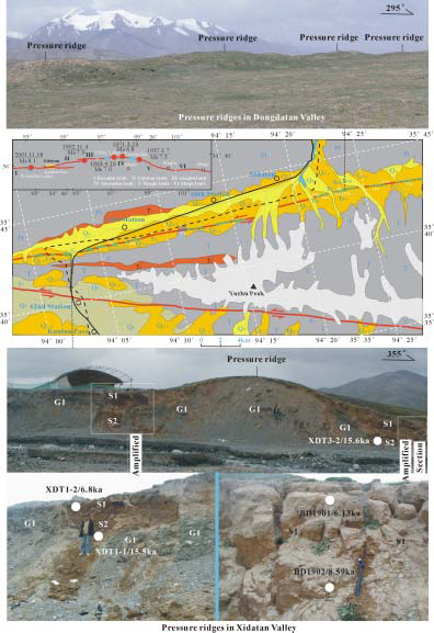
Fig.5 Map of active faults in southern Kunlun Mts.
Explanation: I-Kusaihu fault (F7); II-Xidatan fault (F6); III-Alakhu fault; IV-Tuosuohu fault; V-Dongqingou fault; VI-Maqufault; Numbers 49,18,27 marks sinistral offsets of terraces and streams (m); Q4-Holocene alluvial and fluvial gravel, sand and soil; Q2-3-Middle-Late Pleistocene moraine and glacial flood deposits; Q1-Early Pleistocene lacustrine deposits; T-Triassic slate; P-Permian schist; γ51-Triassic granite.
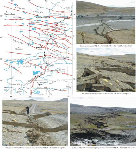
Fig. 6 Seismic fractures of Ms 8.1 Kunlun Earthquake