Groundwater Quality Safety and Contamination Recovery

ANALYSIS OF THE REASON FOR HIGH MINERALIZATION CRETACEOUS GROUNDWATERIN BAIYU MOUNTAIN AREA

Updated :10,29,2012

Li Yunfeng1,Feng Jianguo1,Wang Jiangxia1 ,Wu Yaoguo2,Qu Hui1,Hou Guangcai3,4

1. School of Environmental Science and Engineering, Chang'an University, 126 Yanta South Road, Xi'an, 710054, China, E-mail: lyfphd@163.com,  Tel: +86-29-82339960

2. Northwestern Polytechnical University, Xi´an, 710072 China, E-mail: wuygal@163.com,Tel: +86-29-88488018

3. Xi´an Institutes of Geology and Mineral Resources, 166 East Youyi Road, Xi´an, 710054, China, E-mail: xzhguangcai@cgs.gov.cn, Tel: +86-29-87821944

4. Jilin University, Ximinzhu Street 6,Changchun,Jilin Province, 130026, China, E-mail: suxiaosi@jlu.edu.cn, Tel: +86-431-8502595


Abstract:The water resource in BaiYu mountain area in Erdos Basin is very scarce, and the water quality is poor. It is a typical “bitter water region”. In this article, firstlythe authors introduce the complex condition of the cretaceous groundwater quality in BaiYu mountain area. The TDS value of groundwater of Bao-An water-bearing rock group is more than 10g/L and the maximum is 30.95g/L. The groundwater is SO4·Cl saline water. The concentration of SO42- and Cl- are both more than 2500mg/L. Influenced by the high TDS and the complex water quality, the TDS of the base flow of the river in Baiyu mountain area is more than 4g/L. The concentration of Cl- is more than 2700mg/L.The groundwater is muriated saline water. Secondly, from lithofacies and paleogeography, the main geologic structure of the basin, which is known as the Tian Huan syncline, the authors analyze the reasons of high mineralization and complex water quality of cretaceous groundwater in BaiYu mountain area. First, it is influenced by the lithofacies and paleogeography; Second, the special position in geologic structure, that is,it is influenced by the main geologic structure—Tian Huan syncline; Third, it is influenced by the unfree flow condition of the cretaceous Bao-An water-bearing rock group.

Keywords  BaiYu Mountaincretaceous groundwaterHigh Mineralizationlithofacies and paleogeographyTian Huan syncline


1 The Exceeding Lack of Water in Baiyu Mountain Area

Erdos basin locates in the east of the northwest region in our country, go beyond five provinces (municipalities): Shaanxi, Gansu, Ningxia, Shanxi and Neimenggu. It belongs to the middle reaches of Yellow Riverand its square is 370,000 km2. As Erdos Basin belongs to east Eurasia Temperate Zone continental monsoon climate region, it is part of drought and semi-drought region. Lack of surface water and complex groundwater quality is the common characteristics of the water source in the whole basin. The problem of the lack of water, especially the lake of high quality water restricts the development of national economy and improvement of people’s living standard seriously in this area.

BaiYu Mountain, which lies across the middle of Erdos Basin, locates at the common boundary of Shaanxi, Gansu and Ningxia provinces (municipalities), belonging to the South Temperate Zone semi-drought climate region. The annual average rainfall is around 300-400mm. The evaporation is intense, and the annual evaporation is more than 1400mm. The dryness degree is between 1.5 and 4.

The present physiognomy of Erdos Basin is tableland, which is shaped by the development and evolvement of Quaternary period, based on the ancient physiognomy of tertiary. The altitude is mostly over 1200m.

BaiYu Mountain is the highest mountain in the whole basin. The peak altitude is 1750-1900m. It tends towards approximately east-west and descents from west to east. ChenJi Mountain is the highest, reached to1951m. To the north of BaiYu mountain is the Erdos denudative undulating tableland, widely belonging to interior flow region which is composed by desert and sand-cover. In the south of BaiYu mountain is the loessial plateau, where the loess mesa,loess girder,loess hill interlace vertically and horizontally, and there are so many  ravines,so the landform cracked. BaiYu Mountain itself is low-middling mountain which is covered by loess. It is composed of chipping rock of Bao-An group of Lower Cretaceous. It is the watershed of Wuding River and Luo River, and also is the cradle of Malian River, which is a branch of Jing River. BaiYu Mountain not only controls the development and distribution of surface drainage pattern, but also greatly influences the formation of groundwater flow system.

With the characteristics above-mentioned, the lack of water in the BaiYu area is more serious in Erdos Basin which lack of water and is arid. Furthermore, in the whole Erdos Basin, the lake of water in BaiYu mountain area is not only in quantity, but also in quality, making this area “bitter water region”. On the extensive mainland of 9,600,000 km2 in our country, in fact, this “bitter water region” is one of the real water-scarce regions. Not only the underground water pumped out in this area can’t be drunk or used for irrigation because of high mineralization, but also the surface water is high mineralization and can not be use. In some county seats of this area, the water supply required is only 1000m3, however, there is no source of water can satisfy the need.  

The content discussed in this paper doesn’t involve the problem of water quantity in the BaiYu mountain area, but the present condition of high mineralization and poor quality groundwater and its causation.

2 The Analysis of the Present Condition of Complex Quality of Cretaceous Groundwater in Baiyu Mountain Area

Group stratum of Lower Cretaceous is land facies fragmental rock formationIts lithology is complex, composed of sandstone, siltstone and mud stone, which frequently alternate and repetitively fold as multiplayer lamellar structure. It is a multilayer structure groundwater system. According to the deposit gyration and the property of aquiferous medium, this groundwater system, from top to bottom, can be divided into Luohandong water-bearing rock group, Huan River water-bearing rock group and Luo River water-bearing rock group. Considering the BaiYu mountain area, the Luohandong Bao-An water-bearing rock group is not discussed here because it spread fragmentarily. The present condition of water quality in Huan River water-bearing rock group and the Luo River water-bearing rock group in Bao-An group of Lower Cretaceous is mainly discussed in this paper.
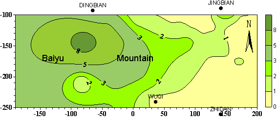
Analysis of the present condition of water quality in Luo River water-bearing rock group: Viewed from the whole basin, comparatively, the quality of the groundwater in the north of BaiYu mountain area is better. Basically, the TDS < 2g/L, and mostly TDS < 1g/L,while the water quality in the south is rather poor. The TDS is quite high girder and ascends from the east and west to the midline, Malian River. The nearer to the midline, the higher the TDS is, and the TDS reached the peak value along the east bank of Malian River, following SE—NW direction. The TDS at the midline is all more than 3g/L. Viewing the whole Erdos Basin. The peak value of TDS presents at the west sector of BaiYu mountain, where it is more than 10g/L and the maximum reaches to 10.45 g/L (Figure 1  The TDS isoline map of the groundwater in Luo River water-bearing rock group in BaiYu mountain area ). The water here is belonged to the type of SO42-·Cl- saline water. The concentration of SO42- and Cl- are both more than 2500mg/L.


 Figure 1 the TDS isoline map of the groundwater of Luo River water-bearing rock group in BaiYu mountain areaunit of concentration: g/L

        Analysis of the present condition of water quality in Huan River water-bearing rock group: As a whole, the distribution regulation is similar to the Luo River water-bearing rock group. The general regulation of TDS is low in the north and east, high in the south and west; the high value of TDS is present along the Yanchi Country—Xunyi Country. In the north of BaiYu mountain area, the TDS is mostly less than 1g/L, even less than0.5g/L. In the south of BaiYu Mountain, the TDS value ascends from the east and west to the midline, Malian Rive, the nearer to the Malian River, the higher the TDS is. The maximum of TDS presents at the west sector of BaiYu Mountain. At the north slope and the foot of BaiYu mountain, there are three small zones where the TDS value is more than 10g/L, one of which is more than 20g/L and at the point where the TDS is maximum, the value is 30.95g/L. The water here is belonged to the type of SO42-·Cl- saline water. The concentration of SO42- and Cl- are both more than 2500mg/L.

From all of the above, we know, the TDS of the cretaceous groundwater in BaiYu mountain area is the highest, and the water quality is the most complex. Influenced by the high TDS and the complex water quality, the TDS of the base flow of the river in BaiYu mountain area is more than 4g/L. The concentration of Cl- is more than 2700mg/L. The type of groundwater is muriated saline water.
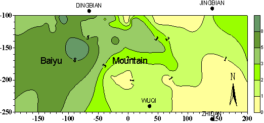


Figure 2 The TDS isoline map of the groundwater of Huan River water-bearing rock group in BaiYu mountain areaunit of concentration: g/L


3 The Analysis of the Reason For the Complex Quality of Cretaceous Groundwater in Baiyu Mountain Area

The reason for such high TDS and such complex water quality of the cretaceous groundwater in BaiYu mountain area is not single. It relates to the location of special geologic structure and special lithofacies and paleogeography condition.

3.1 Influenced by the lithofacies and paleogeography condition of cretaceous in BaiYu mountain area

Regarding the whole Erdos Basin, the sediment environment of Lower Cretaceous stratum includes six sedimentary faciesalluvial or pluvial fan faciesbraided fluviatile faciesmeandering stream facieslake facies and desert facies. The lake facies can be further divided into shore lake and shallow lake sub facieshypabyssal lake subfaciesThe lithofacies and paleogeography of Luo Rive in BaiYu mountain area is showed in figure 3. From figure 3, we can know that Luohe group in BaiYu mountain area includes three deposition environments:lake and fluviatile facieslake and fluviatile mutual facieswind faciesThe lithofacies and paleogeography of Huan Rive group in BaiYu mountain area is showed in figure 4. Figure 4 indicates that Huanhe group includes four deposition environment: fanlike delta facies,delta facies,hypabyssal lake subfacies,shore lake and shallow lake facies. Whether the lake and fluviatile facieslake and fluviatile mutual facies of Luohe groupor the hypabyssal lake subfaciesshore lake and shallow lake facies of Huanhe groupit presented as low-lying landform at that time, and it connected the north and south foot of BaiYu mountain, spreading across the BaiYu mountain. In additionThe lithofacies and paleogeography of Luohandong group in the west of BaiYu mountain is a more longer and narrower lake and fluviatile facies low-lying zone, connecting the north and south. The lake and fluviatile facies low-lying zone of the lithofacies and paleogeography of three water-bearing rock groups of Bao-An group, on the whole, superposes with the axis of Tian Huan syncline. And this makes the water in each aquifer in the east and west drain to the lake and fluviatile facies low-lying zone of the three water-bearing rock groups of Bao-An group, forming the drainage zone. As a result, the TDS of the groundwater is high and the water quality is poor in this drainage zone.


Figure 3 The lithofacies and paleogeography map of Luo Rive group in BaiYu mountain area


Figure 4 The lithofacies and paleogeography map of Huan Rive group in BaiYu mountain area

3.2 Influenced by the main geologic structure--Tian Huan syncline in the basin

        Tian Huan syncline is the main geologic formation of the cretaceous in the artesian basin, from the east of Zhuozi Mountain in the north to the Jingchuan in the south, across BaiYu Mountain in the middle. The length of it is 600km in the north-south direction.

The depth of Tian Huan syncline can reach to lower Paleozoic. But its west wing becomes more narrow and steep when reaches the lower Paleozoic. The main part of Tian Huan syncline is the syncline sructure of cretaceous, which is dissymmetrical, with broad east wing and narrow west wing. The axis of the syncline vertically shifts to east gradually from bottom to top. The most thickness of cretaceous deposit, which can reach 800-1000m, presents along the axis of the syncline. The mainly tend towards of the cretaceous syncline is north-south. It is composed of several spiccato zonary extending sedimentary centers. The position it crossing BaiYu mountain is just the main sedimentary center, where the cretaceous is thickest and the altitude of the top of cretaceous is lowest.

The Bao An group of lower Cretaceous composing the syncline formation is land facies fragmental rock formationIts lithology is complex, composed of sandstone, siltstone and mud stone, which frequently alternate and repetitively fold as multilayer lamellar structure. This iterative overlay multilayer lamellar geologic structure determine that the groundwater aquifer system has the character of multilayerartesian aquifer and the relative closing layer, The groundwater in the aquifer of the two wings of syncline flows horizontally, hardly vertically leakage. Therefore, the groundwater at the axis of Tian Huan syncline comes far from the two wing of the syncline, continually dissolving the rocks in the way continually. The content of the dissolvable salt in the stratums of lake and fluviatile faciesshallow lake faciesdeep lake facies is high, the mineralization of the far coming water cannot but high. Analyzed from the regulation of horizontally zoningthe more down to the lower course of underground runoff,the more nearer the zone of high TDS,and the more complex the groundwater quality is.

3.3 Influenced by the unfree flow condition of the water-bearing rock group

The maximum thickness of the cretaceous deposition can reached to 800-1000m, and that of the Cainozoic group above is hundreds of meters.

As it related above, the groundwater in the aquifer of the two wings of syncline flows horizontally, hardly vertically leakage. When the groundwater arrives at the axis of the syncline, one small part flows horizontally along the axis of the syncline, another small part vertically flows to the up floor.

However, these two types of stream are both unfree. The former, flowing horizontally along the axis of the syncline, is influenced by the more downstream flow from the two wings of the syncline, jamming and robbing the passage. And this makes such a small quantity of the passed water in the upstream. While the vertical current to the up floor travels through the Cretaceous system which composed of sandstone, siltstone and mud stone and which frequently alternate and repetitively fold as multilayer lamellar structure, moreover with the Cainozoic group above, hundreds of meters. As a result, the travel is very difficult, making the groundwater high TDS and complex quality.

4 Conclusions

From the study of this paper, the following conclusions can be gained:

1. Baiyu mountain area is exceedingly short of water, not only in the quantity, but also more lack of high quality water that can be drunk and irrigation..

2. Baiyu mountain area is the typical “bitter water region”. The TDS of the groundwater in the Bao-An group of lower Cretaceous is more than 10g/L, and it reaches 30.95 g/L at the maximum point. The groundwater of this area mostly is the type of SO42-·Cl- saline water. The concentration of SO42- and Cl- are both more than 2500mg/L. Influenced by the groundwater, the TDS of the baseflow of the river in BaiYu mountain area is more than 4g/L. The concentration of Cl- is more than 2700mg/L. It is the type of Cl- saline water.

3. One reason of the high TDS and complex water quality of cretaceous groundwater in BaiYu mountain area is that it is influenced by the lithofacies and paleogeography.

4. The second is the special position of geologic structure it locates, that is, it is influenced by the main geologic structure—Tian Huan syncline.

5. The third is that, it is influenced by the unfree flow condition of the cretaceous water-bearing rock group


References

[1]       Shen Zaoli Hydrogeology, science press, 1985, Beijing.

[2]       M. A. HabermehlThe Great Artesian Basin, Australia BMR Journal of Australian Geology & Geophysics, 5, 1980.

[3]       G..Weinberger E.Rosnthal Reconstruction of natural groundwater flow paths in the multiple aquifer system of the northern Negev (Israel), based on lithological and structural evidence, Hydrogeology Journal 1998.7

[4]       Li YunfengXu ZhonghuaWang JiangxiaWu YaoguoHou Guangcai Guidelines to locate and protect high-quality groundwater in Baiyu Mountain area of China Environmental Geology, Volume 47, Number 5, March 2005, Pages: 647 – 652