2012 Top 10 Geological Survey Progresses
Top1. Dramatic Breakthrough Achieved in Basic Geological Survey
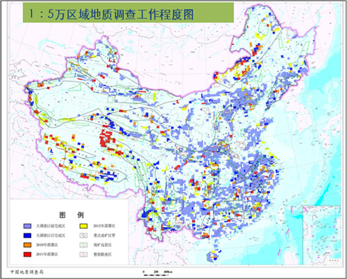
The 1:50,000 mapping was completed for 0.235 million square kilometers with an accumulative total of 2.62 million square kilometers, accounting for 27.3% of land area and increasing by 2.4%. The airborne geophysical prospecting was accomplished for 0.48 million kilometers of measuring lines with an accumulative total of 3.87 million square kilometers, accounting for 41% of land area and increasing by 2.6%. The 1:250,000 regional gravity surveying was accomplished for 0.28 million square kilometers with an accumulative of 5.13 million square kilometers, accounting for 54% of land area and increasing by 3.1%. The 1:250,000 regional geochemical surveying was completed for 0.2 million square kilometers with an accumulative total of 6.13 million, accounting for 64% of land area and increasing by 2.1%. The 1:1,000,000 marine geological survey accomplished covers an area of 0.3 million square kilometers with an accumulative total of 1.5 million square kilometers, accounting for 50 % of the sea area administered by China government and increasing by 10%. At the meantime the actual measurement for three 1:250,000 Qingdao Maps have been carried out. The deep prospecting techniques and experimental research are keeping up with the world, withseismic reflection profile completed for a depth of 6000 kilometers and 6 scientific wells drilled, which successfully make us accomplish the combination of technique innovation and scientific discoveries. Therefore, China has become one of the countries holding the deep prospecting techniques in the world.

The 1:50,000 Regional Geological Survey Schedule


