


Achievements
WAYS OF POLLUTANT TO AN OILFIELD GROUNDWATER
Liu Rong-fang1, Chen Hong-han1, Wang Yan-liang2,Liu Fei1
1
2
Abstract: The study site lies in northeast of
Based on other research, oil pollutant and NH4+-N,NO2--N were the main pollutants of the groundwater in oilfield area. Oil pollutant massed in local area and most scattered in study site and NH4+-N,NO2--N were zonal distribution. To better understand the ways of these pollutants that move into groundwater, results of water samples and their concentration contour with extensive observations made of geologic environment, structural background, currents, surface probable polluting source of the field were combined. Results showed that besides accidental pollution, oil pollutant mainly moved into groundwater by geofractures of subsidence caused by extracted extensive groundwater and neotectonic faults . Lots of water had been extracted near ZK6-drill, which induced cone of depression and made the direction of groundflows changed. At the same time, subsidence and many geofractures appeared in the surface so as to oil pollutants poured into the groundwater. NH4+-N,NO2—N got to groundwater by leaking and geofractures of neotectonic faults. Neotectonic faults went on to move on the base of NW,NNE and EW three crustal fracture belts the main structural faults in study site, accordingly, some channels and geofractures formed. So aquifer was contaminated with spilled oil and other pollutants by the structural fractures.
Keywords: oilfield, groundwater, oil pollutant, geofractures, subsidence, neotectonic faults
The study site lies in an oilfield of
1 Geological Background of Study Site
The study site lies in southwest boundary of Southeast Upheaval in
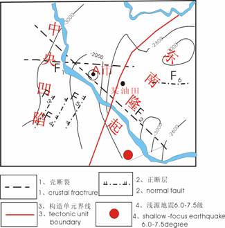
Fig.1 structure outline map of study site
In addition, F2-fault belt included several parallel fractures, which were under NW compressing stress in Paleozoic and still moved under tensional stress in Mesozoic and Cenozoic. The faults incised the Cretaceous even to loose layers of Baitushan Group and Daqinggou Group of the Quaternary, and still moved during Holocene epoch and their structural trails were NW geofractures and channels on the surface. Along the belt, many earthquakes happened and M=6-7 earthquakes appeared 3 times, so it was obviously NW shallow source earthquake-control belt. Furthermore, three groups of NNE parallel crustal faults- F3、F4、F5-dissected the Cretaceous stratum and went on dissecting Baitushan Group and Daqinggou Group during Cenozoic period, the structural marks were channels and geofractures in Holocene epoch.
2 Survey of Groundwater in Study Site
The relief form of the oilfield is singleness, which is Ⅱ-grade river terrace and its surface is flexuous. Groundwater occurrence is in Quaternary stratum which mainly included two aquiferous systems from bottom to top: one was porous pressure aquiferous system of Baitushan Group and Daqinggou Group of lower-mid Pleistocene (for short, lower aquifer), the other was porous tiny pressure aquifer of Daqinggou Group and Guxiangtun Group of mid-upper Pleistocene(for short, upper aquifer)(fig.2).
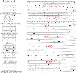
2.1 Water system of porous pressure aquifer of Baitushan Group and Daqinggou Group
The aquifer was formed by coarse sands of Baitushan Group and gravels from the bottom of Daqinggou Group. Because of impermeable layer lost between the two groups in some place, the aquifer was consolidated and its accumulative thickness was 15
2.2 Water system of porous tiny pressure aquifer of Daqinggou Group and Guxiangtun Group
The buried depth of the upper aquifer was 5
3 description of main pollutants in study site
Water samples were extracted from two water systems respectively. Pollution status of the groundwater as followed: The main pollutants in study site were oil pollutant, NH4+-N and NO2_-N,especially oil pollutant which was the biggest menace to the groundwater. Oil pollutant distribution was showed in fig.3:pulltant of the upper aquifer was focused around
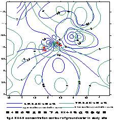
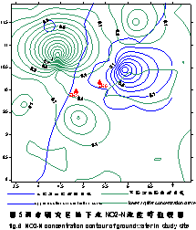
ZK6 and its southwest area, the rest dotted about the whole study site; in the lower aquifer, oil pollutant distributed several km2 near ZK6-drill and its north by east(NE) area, it also scattered about the study site. And oil pollutant in both aquifers possessed very similar distribution and mainly showed heavily polluted spots and medially polluted spots, but its concentration in the lower aquifer was obviously higher than that in the upper(fig.3). As for NH4+-N and NO2--N, they were mainly zonal distribution, especially for those of high concentration. (fig4&5). Although the original concentration of NH4+-N was very high as background value of the study site, it still showed directional distribution by all means. NH4+-N of the upper aquifer was in the direction of north by east(NE), and in the lower aquifer, its distribution was north by west(NW), NEN and near east-west(fig.4). Different from NH4+-N, NO2--N mostly was heavily polluted spots and medially polluted spots, but had the similar characteristics of distribution to NH4+-N. It mainly was NE linear and facial distribution in the upper aquifer, and NW spread was zonal in the lower aquifer(fig.5).
Taking one with another, these pollutants distributed in different ways and contaminated the groundwater to different degrees. And the following text explained the main ways of this status appearance in the groundwater.
4 Ways of Pollutant to Groundwater
Combined with special geological environment and human activities in the oilfield, we found that pollutant to groundwater mainly were three ways: infiltrating pollution, penetrating pollution and accidental pollution. The paper mostly introduced the former two ways.
4.1 Infiltrating pollution
Infiltrating pollution was that pollutants of the ground surface and aeration zone infiltrated into aquifers by loose pores. Because there were several oil wells and earthy oil ponds near ZK6, spilled oil and oil wastewater were the biggest menace to groundwater .Spilled oil affected the shallow groundwater mainly by two ways: one was infiltrated into aquifers with rainfalls directly, the other was those gathered in the surface waters got to aquifers with the surface flows. Pollution by wastewater in earthy oil ponds was caused by infiltration. When earthy oil ponds were disrepaired, crude oil entered into waters (e.g. lakes, rivers) by rainfall and ground flows, thus groundwater was polluted when it was recharged by waters[13]. In addition, main sources of spilled oil including crude oil fall to the ground and oil sand. The crude oil was that didn’t go into the catch oil conduits and fell to the ground. Why this happened as followed:
(1) before an oil spring was put into production, shooting a well to spew instead, and much crude oil entered into earthy oil ponds.
(2) crude oil fell to the well field when oil conduits and oil extract rods used in the wells were placed on the ground or purged.
(3) oil conduits and valves broke down in process of production, and crude oil happened escaping, oozing, dripping and seeping.
(4) crude oil appeared for production accident, such as blowout of oil well, perforation or rupture of oil conduits and so on.
Oil sand was oil sludge that deposited in the bottom of oil storage tanks and setting tanks. Its components were oil sludge and water, but crude oil they contained endangered environment[14]. Firstly, Spilled oil and oil sand belonged to oil pollutant, which could pollute atmosphere when dissolved gases and light hydrocarbons entered into air. Secondly, spilled oil and oil sand unreclaimed would infiltrate into soil and bring pollution.Last, besides affected agriculture, they probably polluted groundwater with rainfall infiltration.
It was reported that numerical simulation forecasted the depth of pollutant in soil was 1.0
Pollution by NO2—N and NH4+-N mainly was caused by two ways: one was that nitride in soils infiltrated through porous media with rainfall or irrigation, the other was pollutant in pits near ZK6 infiltrated into groundwater directly. For example, there was a borrow pit of a brick factory in the northeast of ZK 6 whose area was 6000
4.2 penetrating pollution
Ways of pollutants contaminating groundwater by fractures were penetrating pollution. In the nature, rocks and soil layers were often under all kinds of natural pressures and they usually were distorted under these pressures. When the gathered natural forces exceeded the binding force in rocks and soil layers, the continuity of the layers was broken and fractures happened. These fractures usually closed comparatively tight under the control of ambient rocks and the pressure above, but on the surface, for the definitely free space and the less pressure around, they opened relatively wide and thus they were called geofractures[18]. Two types ofgeofractures which affected the groundwater most usually were sorted on the base of factors inducing their formation[19]. One was subsidence geofracture consisted on extracting extensive groundwater and inducing uneven depression, the other was structural geofracture based on geological structure activities.
5 Penetrating Pollution of Geofractures
5.1 Subsidence geofractures pollution by extracting extensive groundwater
After excessive water was extracted from the pressure aquifer, pressure water level would observably drop and water-head pressure also minished obviously when extracting magnitude exceeded compensating magnitude of the aquifer. This induced pore water flowed out of the original soil layers, which was pore-water pressure minished in them. But the total pressure of the strata was stable, for pressure equilibrium in soils, one hand pressure among the particles of soil would definitely augment, the other hand, density of the clay layer certainly would be higher. Base on above two aspects, ground subsidence occurred in the surface[20].Near ZK6-drill in study site, excessive water was extracted for a long time, as a result, this made cone of depression appear and the changed direction of groundflows. On the surface, geofractures emerged with ground subsidence and showed chronic, paroxysmal and durative characteristics besides characteristics of definite linear zone distribution[14]. Once this situation formed, much pollutant would be focused by streams in channels during rainy season especially flood period, and got to groundwater by geofractures. For this reason, around ZK6-drill,pollutant mostly was zonal distribution. For instance, in the upper aquifer, oil pollutant was facial distribution, area was
5.2 Structural geofractures pollution
On one hand, in study site, the top of Cretaceous stratum was loose because of long-term structural denudation and badly prevented water and pollutant going by, over which Quaternary stratum was also loose. Neotectonic faults still acted on the base of old faults, so there were much obvious rifts and geofractures on the surface. These fissures had directionality, mostly NW and NE took the second place, and thus rhombic and indented channels and geofractures appeared. And two groups of faults appeared near ZK6, and the trend was NW and NE(fig.6). Along the faults, lots of geofractures formed and crude oil and other pollutant would poure into them when it rained. That is groundwater was contaminated by this way. In addition, analysis showed that the distribution of NH4+-N and NO2—N seemed to accord with the faults strike in the lower aquifer and the concentration close to the faults was obviously higher than that of peripheral area. Pollution brought by faults also can be approved by changes of chemical property and solute sources of the groundwater. Chemical property of the lower aquifer was HCO3-Ca different from peripheral HCO3-Na property, that is to say, Ca content was obviously higher that Na content in the study site and showed that besides regional runoff recharging groundwater, afflux from atmospheric precipitation recharged groundwater through channels and geofractures to a great extent.
On the other hand, buried horizon of oil was shallow because of Tertiary stratum lost. The top layers of Cretaceous stratum even the bottom of Quaternarystratum were continually destroyed by structural denudation of neotectonic activities and their geological construction was also ruined, moreover, groups of NNE and NW faults and their sub-faults dissected the top Cretaceous even the bottom of the Quaternary which became weakness of stratum construction and geological environment and easily to be energy acceptor when affected by energy conversion. Under the special geological conditions, formation fractures of the oilfield enhanced occurrence of active faults and their sub-faults and fissures, which brought the top Cretaceous and the bottom of the Quaternary was destroyed more severely or fractures appeared by energy conversion, all these would blight environment. Aftereffect as followed: (1) Active faults and fractures brought by energy conversion made the most weakness of underground-well effuse sand, and the sand exceeded water level of the well even the aquifer, which led to the well ruined. On the east of ZK6, a Quaternary pressure water well was disused for effusing sand. (2) Acted by compression and fissuration, natural gas of oilfield transferred into the Quaternary aquifer along active faults and fissures, and focused into the most weakness of underground – wells or spilled, even be fired abruptly for intervening acts of human(e.g. switch on or off etc.). For example, a village well in the WN ZK6 once fired and its cover was tipped. (3) Acted by compression and fissuration, crude oil moved into Quaternary aquifer along the active fractures and fissures, and even caused oil effusing in the water well. This kind of situation appeared more near ZK6-drill. In the west of ZK6, a well was discarded for effusing oil after the oil producing well
Neotectonic faults inherited activities of three groups of crustal fractures, and two groups of faults –NW and NNE faults-made the interface of the base rock up-and-down. Furthermore, because NNE-faults revived, the upcast side of Baitushan Group uplifted and made the layers become very thin even deficient for erosional cutting, but Baitushan Group west of study site became thick and stable owing to in the downcast side (fig.8). Some literature[18]recorded that buried depth of base rocks in a place obviously affected the geofracures occurrence if the depth was less than
All in all, the factors resulting in geofractures occurrence were multifarious, even several factors together worked generally. For example, fractures cause by project construction and special freezing fractures in


6 Conclusions
Ways of pollutant to groundwater mainly were infiltrating pollution, penetrating pollution and accidental pollution. But infiltrating pollution endangered groundwater quality to a small degree, most was nitrides pollutant. Penetrating pollution caused by channels and geofractures and accidental pollution were the main part causing serious multi-pollution. Studied fractures in study site mostly were brought by neotectonic faults and ground subsidence for extracting extensive groundwater. As for other causes of geofractures formation, we need to continue working on lots of researches and studies, such as causes by other neotectonic activities, project construction, cold weatherand so on. When groundwater contaminated, urgent affair was to control the pollutant spreading in groundwater and to treat waste water from pollution sources. Because spilled oil and oil-bearing wastewater were the main sources of groundwater pollution, moreover, domestic wastewater and irrigating wastewater were main sources of nitrides , supervisors of environment department of oilfield and the city were suggested as followed:
(1) correctly treating spilled oil and oilfield wastewater, and the treated water must be up to the groundwater quality criterion when the wastewater was injected into underground or discharged.
(2) periodically checking up oil conduits and oil wells, this reduced groundwater pollution essentially.
(3) reasonably planning extraction of groundwater in subsided areas, trying to avoid enlarging the degree of ground subsidence. In addition, the oilfield was encircled with rivers in the directions of south, west and north, so utilizing surface water in light hand was a very effective method to alleviate environmental crisis.
(4) correctly treating domestic wastewater and irrigating wastewater and avoiding they were discharged randomly.
References
[1] [1] Guo Huaming,Wang Yanxin,Chen Yanling,Wang Yumei.Geochemical Indicators of Organic Contamination in Groundwater: a Case Study in
[2] [2] Li Lingbo,Lin Daquan,Ji Wei,et al. Characterization of Organic Contamination at a Petrochemical Site Ⅱ.Groundwater[J].Acta Petrolei Sinica(Petroleum Processing Section),2001,17(6):84-90 (in Chinese)
[3] Wang Yumei,Dang Junfang.Analysis on Groundwater Pollution in Oil and Gas Fields[J]. Journal of Geological Hazards and Environment Preservation,2000,11(3):271-273 (in Chinese)
[4] Chen Yudao,Zhu Xueyu,Wu Sansan.Pollution From of Petroleum Hydrocarbons in Subsurface Water Sources of Linzi Area in Zibo City[J].Carsologica Sinica, 1997,16(1): 35-40 (in Chinese)
[5] Wang Hongtao,Luo Jian,LI Guangfu.Numerical Simulation of Oily Wastewater Contamination of Subsurface Soil and Phreatic aquifer[J].Tsinghua Univ(Sci & Tech),2000,40(11):109-113 (in Chinese)
[6] [7] Lü Hua,Ma Zhenmin.Investigation and Prediction on Groundwater Oil Pollutes of a Target Area[J]. Nonferrous Metals, 2005,57(2):145-149 (in Chinese)
[7] Chen Yudao,Jiang Yaping,Huang Zongwan,et al.Physical Model for Petroleum Contaminated Shallow Groundwater System[J].Journal of Guilin Institute of Technology,2004,24(4):492-497 (in Chinese)
[8] Xue Qiang,LIANG Bing,Feng Xiating,Liu Jianjun.Numerical modeling with multiphase flow model of petroleum pollutant transport in subsurface environment[J].Journal of Chemical Industry and Engineering,2005,56(5):920-924 (in Chinese)
[9] Wang Hongtao, Zhou Fusheng, Gong Huili. Numerical Approach in the Assessment of Oily Wastewater Contamination to Groundwater in the Oil Field Development[J]. Acta Scientiarum Naturalium Universitatis Pekinensis,2000,36 (6): 865-872 (in Chinese)
[10] Xi Chenggang,Chen Jiajun,Xu Zhaoyi.Risk Assessment of Accidental Environment in Oil Field Exploitation[J].China Safety Science Journal, 2002,12(3):35-38 (in Chinese)
[11] Yi Mingchu.Neotectonic Activity and Regional Crustal Stability[M].Earthquake Press,2003:3~6 (in Chinese)
[12] Zhang Xingru. Environmental Affection by Development and Construction of oilfield[M]. Bingjing Petroleum Industry Press,1998 (in Chinese)
[13] He Furong. Basic Knowledge of Environment Protection in Oilfield[M].Petroleum University Press,1997:107-111 (in Chinese)
[14] Al-Sarawi M,Massoud MS and Al-Abolali F. 1998. Preliminary assessment of oil contamination levels in soils contaminated with oil lakes in the Greater Burgan Oil Fields , Kuwait .Water , Ai r and Soil Pollution,106 :493-504
[15] Al-Sarawi M,Massod MS and Wahba SA. 1998. Physical properties as indicators of oil penetration in soils contaminated with oil lakes in the Greater Burgan Oil Fields , Kuwait .Water, Ai r and Soil Pollution ,102:1-15
[16] Zheng Xilai, Jing Jing, Xi Linping. Transport and degradation of oil in unsaturated zone [J].Hydrogeo and Engin Geo, 1998,25(1) :35-37 (in Chinese)
[17] Xie Guanglin.Geofracture, Earthquake Press,1988 (in Chinese)
[18] Yu Jun, Wang Xiaomei, Su Xiaosi, Yu Qin.The Mechanism Analysis on Ground Fissure Disaster Formation in Suzhou-Wuxi-Changzhou Aarea[J]. Journal of
[19] Huang Chengmin. Environmental