


Achievements
THE RESPONSE OF WETLAND AND GROUNDWATER SYSTEM IN THE YELLOW RIVER DELTA
Song Shuhong
Institute of Hydrogeology and
Environmental Geology, CAGS,Shijiazhuang, P.R.China e-mail: ssh5228@163.com
Abstract:Various problems are concerned with groundwater and
induced by exploration and utilization of the groundwater in the Yellow River
Delta, such as wetland degradation, soil saline and alkaline soil, seawater
intrusion etc. The geological environment is fragile. Based on the groundwater
table and the hydro-geological conditions, combining with the characteristics
of micro-topography, a model depicts the response of the wetland protected and
the extracted groundwater was built to solve the problems, the feasible data
were provided for the utilization of groundwater in the Yellow River Delta.
Key words Yellow River Delta
(YRD); wetland; groundwater; water resource; water environmental.
The Yellow River Delta in this paper is the modern delta, an alluvial fan that is made up with great amount of Quaternary fluvial deposit of the Yellow River since 1855. It lies along the seacoast of the Bohai Gulfand the Laizhou Gulf. The average elevation is lower than 15m, with total area about 5450km2. According to Chinese administrative region partition, Dongying city of Shandong Province is the main part of the Yellow River Delta. Because of the fluvial deposition of the Yellow River, new land has been formed on the estuary delta gradually. According to Hu Chunhong et al. (1996), average rate of the estuary extruding into the sea is about 2.6km/a, and a relatively lower rate has been observed recently, which is about 1.1 km/a (Ding Dong et al., 2001). Accordingly, the wetland has been expanded and extruded into the sea gradually, and about 21.3 km2 sea area is replaced by new formed land every year (Xu Jianmin, 2001). The Yellow River Delta is a typical estuary wetland, which has not only the most complete but also the youngest wetland ecosystem types over warm temperate zone in China. Therefore, it is an ideal area to study the formation, evolution and development of the newly formed wetland over estuary area.
1 The Wetland Ecosystem of the
Yellow River Delta is Fragile and Affected by the Yellow River Water
Evidently
1.1 The wetland ecosystem of
the Yellow River Delta is fragile
Due to the low and flat
topography, the river flows very slowly and lots of wetlands have been formed
in Yellow River Delta. The total area of the wetland is about 333,427km2.From
the view of hydrology, the perennial wetland is main part that accounts for 63%
of the total wetland area and the seasonal wetland area occupies 37 %( Xu Jianmin,
2001). Since the wetland has been formed or developed with the
relatively short time and main land cover is still the grass vegetation, the
ecosystem is very fragile to the outer environmental change, especially for
some species, such as red-crowned crane, whose is easy to be hurt due to the
lower ability of propagation.
According to the
effect of human activity, the wetland in the Yellow River Delta can be
classified into two categories, natural wetland and man-made wetland. Natural
wetland is the wetland that is not or rarely disturbed by human activities for
the moment, such as shallow sea or beach wetland, river wetland, swamp, meadow
wetland and natural freshwater area etc. Man-made wetland is the wetland that
is fiercely affected or developed by human activities, such as reservoir,
ditch, paddy field, breed aquatics pool and saltern etc (Chen Weifeng et al.,
2003). In recent years, the total area of wetland has been increased, of which
the natural wetland area has been decreases and that the man-made wetland area
has been increased (Table 1). At present, the man-made wetland occupies 1/3 of
total wetland area and the natural wetland is inclined to decrease and
degenerate, and that the total area of wetland is more or less keep the same.
Since 1998, the zero-flow season of Yellow River hasn’t happened any
more, so the development wetland ecosystem is stable.
Table 1 The area of different types of
wetland in the Yellow River Delta (Dongying) during 1981-1998
|
type paddy field reed
field beach salt field reservior pond |
|
1981 4763.6 69223.9 80000 335.2 1954 30000 1990 25409 32721 86068 2628 12831 12945 1998 19103 24382 101914 3721 14410 18846 |
(after Xu Jianmin, 2001)
1.2 The wetland area is
affected by income amount of the Yellow River
Water is essential for wetland
and the natural condition of wetland is affected by the quantity and quality of
available water sources (Yang Zhifeng, et al., 2003). Yellow River is the main
water source of the study area, which formed and maintained the wetland
ecosystem, and the wetland area is affected by total incoming water resources
of Yellow River. During 1985 to 1997, when the Yellow River drainage
area is continually dried up, the incoming water went on reducing. As a result,
converse succession took place in the seral
community, some halophilic enduring vegetation
has been developed, and the area of reed wetland decreased while the
area of reservoir, pool and saltern increased, the overlay rate of vegetation
reduces obviously. Some animals and plants surviving by wetland decrease
obviously, and the original ecosystem of the estuary have been degenerated
(Chen Weifeng, et al., 2003).
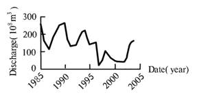
Figure 1 Time-series runoff of
the Yellow River at the hydrology station in Lijing during 1985—2005
2 Groundwater System
2.1 The dynamics of
groundwater system in rainy season and dry season
The dynamics of groundwater is
mainly affected by precipitation, evapotranspiration (including evaporation and
transpiration),irrigation and drainage (Guan Yuanxiu, 2000). Under the certain
circumstance, for example, climate conditions, topography and geological
background, the more water comes from outside, the more highly of the local
groundwater table rises. Hence, the groundwater table is higher in rainy
seasons while lower in dry seasons.
14 points in the Yellow
Delta(Dongying) and 43 points that lie in Dongming、Yuncheng、Liangshan、Dongping、Jiyang、Ji’nan、Qihe、Dong’e、Yanggu etc in the low reach of
the Yellow River has been investigated and groundwater levels measured in
different seasons are shown as Fig.2 and Fig.3 respectively. As it is shown,
annual amplitude of groundwater
table is lower with the maximum less than 1m in Yellow River Delta,
while the maximum can reach 4m in other area.
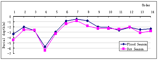
Figure 2 Comparison between groundwater table in rainy
season and dry season in the Yellow River Delta
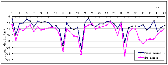
Figure 3 Comparison between groundwater table in rainy
season and dry season in the Yellow River low reach plain
2.2 Due to the modulation of
wetland, the dynamic of groundwater table is less in rainy season and dry
season
The flood season of the Yellow River includes July, August and September, which is also the rainy season of the Yellow River, and due to the time-lag, the effect of the incoming Yellow River water on groundwater system will be obvious soon later. Hence, the time for groundwater levels measuring is selected in the last ten-day of September when these wells had accepted water supply from rainfall and seepage of the Yellow River. The data observed in the Yellow River Delta indicates that the dynamics of groundwater table is less in rainy season and dry season due to the regulation function of the Yellow River Delta wetland. In addition, the great environmental regulation function and ecological benefit of wetland is reflected not only by the groundwater systems, but also for water supply, climate adjustment, water resources protection, flood control, silt promote, new land formation, contamination degradation, and biological diversity maintaining.
3 Reasonable Utilization of
Wetland to Ensure its Function
While natural
wetland area in the Yellow River Delta decreased and manual wetland area
increased, the regulation ability of wetland decreased. The construction of
manual wetland is for the sake of raising the groundwater table to supply
wetland by using the Yellow River for irrigation. Since 1999, a
project to recover the ecosystem of the wetland has been implemented, and by
the end of 2004, the area of wetland with fresh water had been enlarged
obviously and more than 1.3´104ha salted land had been reclaimed
to wetland. Because maintain of manual wetland depends on the directly
supply of the Yellow River water, the effect on the man-made wetland by Yellow
River is stronger compared with natural wetland. However, due to the bare
land presented, man-made wetland has less ecological functions.
Because water
quantity of the Yellow River is not stable and the available water
resource is limited, reasonable exploitation and utilization is a guarantee to
ensure the well development of the environment. In the case of manual
irrigation, the water resources needed by wetland ecosystem should be fully
taken into account. According to Cui Baoshan et al(2003), the water resources
requirements for the wetland in Yellow River Delta area should be with in the
range of 9.8~12.6´108m3 to 36.7~42.7´108m3 to
maintain the healthily development of the wetland, and the optimal water resources required is 23.4~28.2´108m3.
4 Conclusions and Discussions
The Yellow
River has an affect on the regional environment through the groundwater
system, and vice versa.
The wetland
ecosystem in the Yellow River Delta is dominated by climate and incoming water
resources of the Yellow River. The environmental factors such as geologic
condition, climate etc. can be regarded as connatural, but the groundwater
table and the means of land utilization can be changed, so the effect of human
activities can not be ignored. In the process of human activities to change the
nature, the order of nature should be fully considered to promote the relation
between humanity and nature. In order to realize the sustainable development of
the Yellow River Delta area, the relations between incoming water resources
fromYellow River, regional groundwater levels changes and water requirement of
wetland should be know clearly.
Based on previous
discussion, a model that reflects the response among wetland area, shallow
layer groundwater table and the incoming water resources from Yellow River were
constructed as following:
where, Ls is
wetland area, t-1 forecast time, t original
time, EI income water resources, GWd groundwater
table, St climate, Lt tiny physiognomy type, Lu means
of land utilization, Cl water resources of the Yellow River
(runoff observed in Lijing station), “Cl”corresponds to “GWd” and
“Ls” in the model.
Taken the wetland in Yellow
River Delta area as a pilot, a model that depicts the response between total
areas of wetland, shallow groundwater leves as well as incoming water resources
from Yellow River were constructed, which is believed to be
meaningful to guide the reasonable utilization or local water resources.
References
[1] Hu
Chunhong Ji Zuwen Wang Tao. 1996. Characteristics of ocean
dynamics and sediment diffusion in the Yellow River estuary [J]. Journal of
Sediment Research, (4):1~10 (in Chinese with English abstract).
[2] Ding Dong,Li Rihui. 2001.
Study and proerctlon of wetland in the Yellow River mouth area [J]. Coastal Engineering, 20(3): 33~39 (in Chinese
with English abstract).
[3] Xu Jianmin. 2001. Study on
Evaluation and Sustainable Utilization of the Wetlands in Yellow River Delta
(Dongying) [D]. Chinese Academy of Agricultural Sciences, Ph.D. degree thesis (in Chinese with English
abstract).
[4] Cheng
Weifeng, ZHOU Weizhi, SHI Yanxi, etc. 2003. Crisis of Wetlands in the
Yellow River Delta and its Protection [J]. Journal of
Agro-Environment Scirnce, 22(4): 499~502 (in Chinese with English
abstract).
[5] Yang Zhifeng, Cui Baoshan, Liu
Jingling, etc. 2003. The theory and methods of ecological and environmental
water and its application [M]. Beijing: Scjence Press (in Chinese with English abstract).
[6] Cui Baoshan, Yang Zhifeng,
2003. The classification and case study on eco-environmental water requirement
of wetlands [J]. Resources science, 25(1):21~28 (in Chinese with English
abstract).
[7] Guan Yuanxiu, Liu Gaohuan,
Wang Jinfeng. 2001. Regionalization of Salt-affected Land for
Amelioration in the Yellow Rover Delta Based on GIS [J]. Acta geographica
sinica, 56(2):198~206 (in Chinese with English abstract).