Chuyu1 ,Zhang fenglong2 ,Yang
xiangkui1 ,Guo hongbin2
1 Hei Long-jiang
institute of Geological Survey,Hei Long-jiang province,Harbin city,150036,China;
2 No.904 Hydro-geology
and Engineering Geology team, Hei Long-jiang province ,Shuang-cheng city ,
150111,China
Abstract: The northeast plain is composed of Songliao
Plain, Three River plain, Xingkai Lake Plain and Hailaer
High Plain. Through analyzing petrofacies of these plains, We found that the
ancient hydrology net had changed sever times in this four plains in 3.00 Ma.
Key words: P. R., 3.00 Ma; the northeast plain, Ancient
hydrology net, changed
1 In 3.00-2.5ma,bp
The four plains composed inland separate
embryonic hydrographic net .A big lowland near Da,an on the Songliao
Plain .Ancient Nen River ran along Lindian and Taikang into it and ancient west
Liao River ran along Tongliao and Qian’an into it(Fig.1) .Other
branch rivers had not formed.
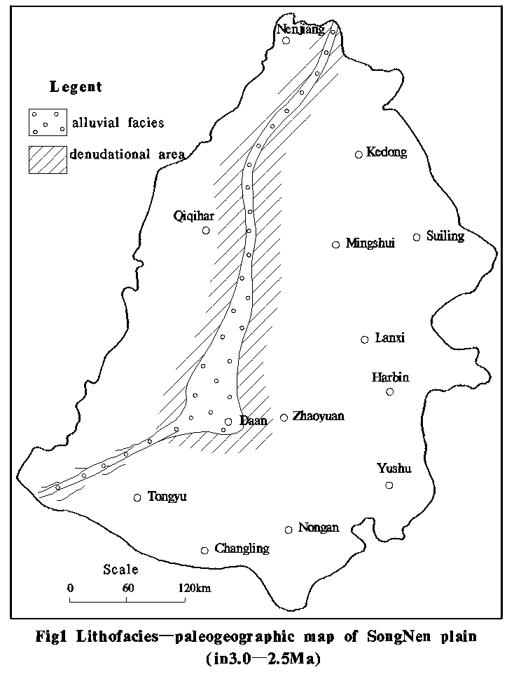
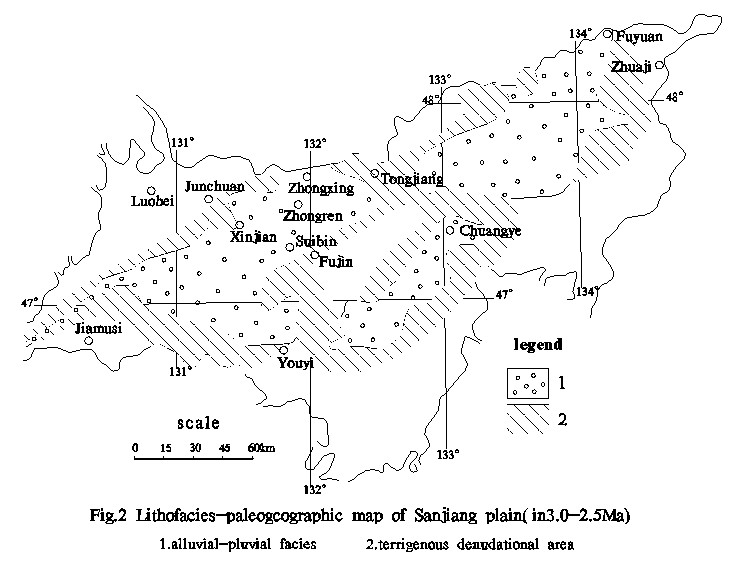
There were only three ancient lowlands in
Three River Plain. The ancient Songhua
River was a small
river and ran into
a big lowland(Fig.2),and its branch river had not formed. The Xingkai Lank
Plain had deposited 30-50m
alluvial deposit near the Songacha River and there was only one big waters, the Beier Lake,
on the Hailaer High Plain .
In conclusion, in this epoch the ancient
rivers on these plains were short, and the branch rivers were few. So inland
separate embryonic hydrographic nets were formed .
2 In 2.5-1.00 ma ,bp
The ancient hydrographic nets on these four
plains were still separated. Except the ancient hydrographic net on the
Songliao Plain ran from the south to the north and then into the sea, other
three plains were still inland hydrographic nets.
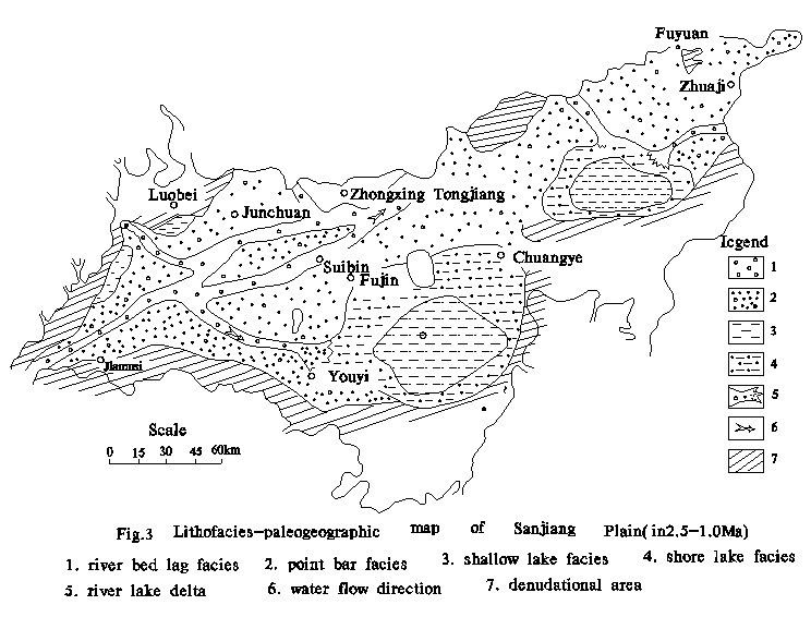
In 2.5-1.00 Ma
,BP, the ancient Shonghua
River maturated, but was
still inland hydrographic net. And there was a big lake on the plain. The
ancient Nen River maturated and formed a big lake near Kangtai,Da,an
and Tongliao.Its south segment ran through Zhangwu into Xia Liao River and then
into the sea .Its north segment ran through Sunwu Graben and joint with the
Jieya River in Russia ,so it formed a through north-south hydrographic net.
There were two big lakes and rivers which ran into the lakes in Beier Lake
and Handagai on the Hailaer High Plain, so these formed another inland hydrographic
net. There were two big lakes and rivers which ran into the lakes on the
Xingkai Lake Plain(Fig.3) ,and it also an inland hydrographic net.
3 In 1.00-0.70 ma ,bp
There was a very impetuous crustal movement
in northeast China.
The effect of this crustal movement was very dip, because it changed the
pattern of mountains and rivers. Because of this movement mountains around the
four plains lifted fast. Especially the north segment quickly lifted, so the
road was blocked, through which Jieya River ran the Sunwu Graben to Songliao
Plain .The mountain north of Xia Liao River was lifted ,so the road the
Songliao hydrographic net ran south was blocked. So the Songliao hydrographic
net was an inland hydrographic net in this short time. It is obvious that the
dividing ridge of the Songliao Plain was the mountains north of the Liao River
Plain .
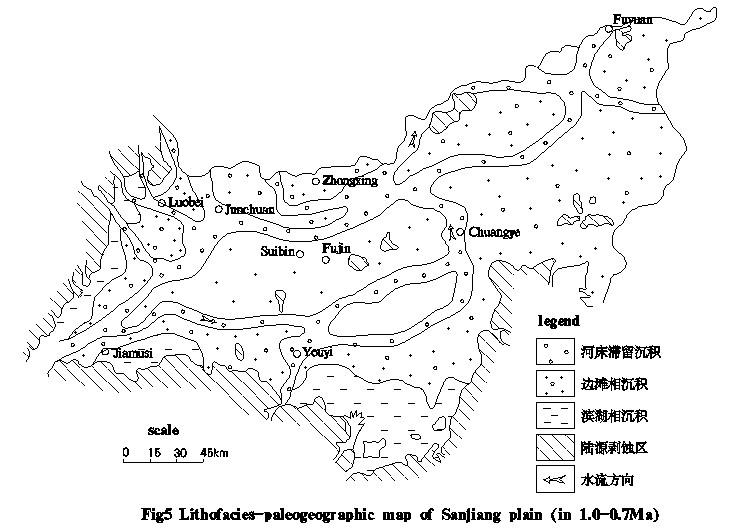
In 0.7 Ma,BP, the ancient Songhua River
ran along the Yiyin Graben through the Yilan
Canyon ,and the ancient Heilong River
ran through the Jiayin
Canyon . The two river
all ran into the Three River Plain. At this time ,the Three River Plain and
Songliao Plain ancient hydrographic nets connected(Fig.4).Except the Hailaer
High Plain and Xingkai Lake Plain hydrographic nets ,the ancient Heilong River hydrographic net had all
transfixed. After jointed
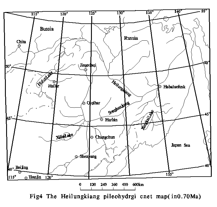
with the big
branch rivers ,it ran to the north in the Fuyuan on the Three River Plain
,through Russia
into the sea .It changed into a outward hydrographic net.
Then why we say
the ancient Heilong
River changed into a
outward hydrographic net in 0.7Ma ,BP?
The author
analyzed the ancient geography of the ancient Songhua River and Heilong River
petrofacies on the Three River Plain(Fig.5) ,and found that the deposit of this time was
different from the underlie Quaternary deposit. Its grain size was bigger and
the containing water was more .The geophysical exploration also proved the
electrical resistivity was 1-3 times higher than the underlie stratum. These
all proved that the flux was very big. It is no other than the hydrographic net
ran through the Yilan Canyon and Jiayin Canyon and jointed with upper course
hydrographic nets .The chronology proved this series deposit strata was in 0.7
Ma,BP. Otherwise there was no other big lake on the Three Lake Plain and the
lake was dead in early Pleistocene epoch. This also proved the Heilong River was outward.
So the Heilong River was outward from 0.7 Ma,BP.
4 in 0.7-0.02 Ma,BP
The ancient Heilong River jointed with other hydrographic
nets on the Hailaer High Plian ,Songnen Plain ,Three River Plain and Xingkai
Lake Plain. These formed the Heilong
River hydrographic net
ran outward into the sea. The ancient Xia
Liao River
captured the west and east Liao
River and ran south into
the sea .
In the mid
Pleistocene epoch ,the ancient Heilong
River was confined of the
change of the ancient climate and the crust movement. In the interglacial
period and the stratum fall epoch, the flux change mach, so the mid Pleistocene
epoch was a prosperous time of the two lakes. The Songliao Plain, Three Plain
and Xingkai Lake Plain all fell down. It caused the deposit range reached the
posterior border of the nowadays platform. The lake was at the height of the
development. The ancient Three
River Lake
move south to the area around Baoqing and Shuangyanshan. There were big lakes
near the Jixian ,Tangyuan ,and Heli. The ancient Xingkai
Lake reached the edge of the platform
and the Muling River divided into two branch into it.
The Songliao Big Lake
extended to the east high plain edge. The Hailaer High plain and Hulun lake
formed and these ware joint with Beier
Lake. When the glacial
epoch came , the lake holded back or dead and the river developed. The
pan-shaped plain was formed front of the mountain.
In the 0.2 Ma,BP,
there was another crust movement in the northeast China. This movement was not as
impetuous as the early Pleistocene epoch’s. But to the northeast it was very
important. In this movement the edge of the plain keeping lifting ,which caused
the mountain stream formed and it cutting the valley deeply. Big changed
happened in the Songliao Plain. Its east part, the high plain, lifted quickly
and stopped depositing. Its west part, the low plain, went on lowing and into
river and lake faces. There is an explanation that the high plain lifted had
obvious differently, so the ancient Liao
River changed. In the
beging the palace of origin of the east Liao River
was Hada mountain. But in mid Pleistocene epoch it was south-north, and ran
into Songnen Plain jointed with the Songhua
River. There was an
obvious watershed between it and the second Songhua
river’s branch ,yitong river. This watershed in stream source area,the Dahu
mountain to the Kaoshan town, and though the Dahei mountain then into the
Songnen High Plain. In the late mid Pleistocene epoch the Songliao big lake was
in the height developing period ,so the high plain was submerged by the lake.
And so the second Songhua River ,Yitong
River and east Liao River
ran into the Songliao big lake on the edge of the high plain. In the mid
Pleistocene epoch and the beging of late Pleistocene epoch the high plain
between Huaide and Yongjiu town lifted quickly, and the road the east Liao River
ran to the north was blocked. So the ran west like an arc, round the mole
track. And at this time the Liao River’s head erosion was intensive, cutting through
the east Liao mountain and captured the east Liao River.
So it ran south to the sea. So it proved that the watershed between the east Liao River
and Songhua River was formed between the mid
Pleistocene epoch and the beging of late Pleistocene epoch, in 0.2Ma,BP.
The scientist of
geonomy have paid much attention to the space-time locating of the watershed Between
Songhua River and Liao
River. Especially where
is watershed between the west Liao River and Nen River
on the low plain, and when it formed. And there is still not last words. But
the author found that there was on watershed on the low plain, through the
geologic investigation of the desert environment .
Science the mid
Pleistocene epoch the west Liao River ran into Songnen low plain ,and became a branch
of the Nen River. Then when and why the west Liao
lake diverted east into the Xia
Liao River
The author considered that it because of the change of the ancient climate and
ancient hydrological environment. In 0.035-0.2 Ma ,BP, in the interglacial
period of the last glacial epoch, the ancient was relatively warm and wet, and
rainfall grew sharply. The flood of the Nen
River and Songhua River
happened frequently. Through the analysis of the deposit on the low plain in
this period, the low plain from Qiqihaer south to Tongliao was submerged by the
flood, formed the biggest lake in the end of late Pleistocene epoch. Because of
the flood form the east ,after the west Liao River
ran into the Liao province, the two water jointed. It not only caused the water
height lifted ,but also caused the west Liao River ran slowly and diverted east
to jointed with east Liao River, then ran south into the sea. At the same time
,the two water jointing caused the hydroenergy became low. So the sand its
carried deposited, and formed a very big lacustrine and fluvial
natural banks. These natural banks distributed widely on the west Liao Plain
Ke’erqin area. It also was called ke’erqin dene, about 40369 km2.
The
shadows of this area’s natural banks were very clarity in the satellite photo
maps, and being with downright regularity. The natural banks that formed by
lake present in arc along the south bank of Song Liao big lake, and from Ke Zuo
Zhongqi to Chang Ling, to Tong Yu area have more than 10 lakes forming into
natural banks with grandness scenery. The level of the natural banks are
commonly higher than the on site’s base level 15-20m, width 4-6Km,
length 80-250 Km. The
billabongs among the banks are ponds and meadows composing with matter of
lake,
and lower with fine sand, silt; higher with shallow layer of silty sandy soil
(so the soil is easy to form into dene when it’s vegetation is destroyed).
The
natural banks that formed by lake parallel distribute along the river, and the
natural banks that heading northwest orientation distribute in the northeast
bank, such as Cha Ganmulun River, Wu Erjiren River, Hu Huer River. The natural
banks are 15-25Km
length, 1-2Km width, 15-20m high. The natural banks that heading
southwest orientation mainly distribute in the east bank, such as Gu Erguli
River, Ge Shaguole River. The natural banks are 15-25Km length, 1-2Km
width, 15-16m high. The natural
banks that heading to east and west orientation mainly distribute in the south
bank, such as Xi Lamulun River. The natural banks are 300Km length, 10-20Km
width, 15-20m high.
In the
20,000 years, the geologic climate became cold and dry, and especially in the
prevailing glacial epoch in 18,000 to 15,000 years the geologic climate
achieved the coldest period. The ancient Song Liao big lake quickly died out,
at that time, the water distribution homologized reducing, so it had no ability
any longer to break through natural banks that blocking at its forward road and
to inflood into Song Nen Plain. Thus, West
Liao River
viz. turned into permanent anabranch of Xia Liao River. It is obvious that in 20,000
years should be the period that the West
Liao River
divagated to east and rushed down and converged at Xia Liao River.
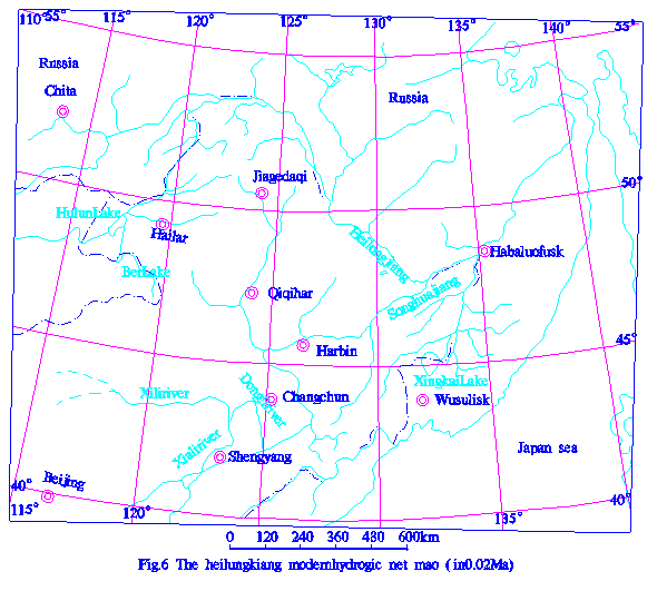
At the
same time, the Hailaer high plain from west to east and the Xing Kai Lake plain from southwest to northeast tilted raise,
which led the water of the Hulunbeier Lake and Xing
Kai Lake
rushed out and became the Heilong
River water system. Thus,
Heilong River water system connected the water
systems four plains and came into being a uniform rushed out water
system(Fig.6).
Reference :
[1] Zhangqingyun,
1992, The form and development of watershed between the Songhua
River and the Liao River,
The corpus of the natural environment formed and changed of northeast plain
during Quaternary.
[2] Qiushanwen,
1992, The study on the form and development of the Ke’erqin dene, The corpus of
the natural environment formed and changed of northeast plain during
Quaternary.
[3]
Chubenjun, 1998, the geology and environment of Heilongjian province during Quaternary
The ocean publishing company.
[4] Chubenjun
1989 Study about the Taikang formation of the Song Nen Plain Geological Review
Vol.35 (2).
[5]
Chubenjun 1989 the first step of dividing the Quaternary strata of Song Nen
Plain, Marine. Geology and Quaternary Geology, Vo1.8.No.4


