


Achievements
GROUNDWATER SYSTEM AND RESOURCES OF THE ORDOS BASIN, CHINA
Hou Guangcai a,b,Liang Yongping c, Yin Lihe d, Su xiaosi a, Tao Zhengping b,Zhao Zhenghong b, Yang Yuncheng b, Wang Xiaoyong b
a. College of Environment and Resources, Jilin
University,
b. Xi’an Institute of Geology and Mineral Resources,
c.
d. China University
of Geosciences,
Abstract: The Ordos Basin is a large-scale sedimentary basin in Northwestern China. The hydrostratigraphic units from
bottom to upper are pre-Cambrian metamorphic rocks, lower-Paleozoic carbonate
rocks, upper-Paleozoic to Mesozoic clastic rocks and Cenozoic deposits. The
total thickness is up to 6000m.
Three groundwater systems are present in the
Key Words: groundwater system, circulation and evolution,
groundwater resources, the
1 Introduction
The Ordos Basin
is located in the east of northwestern
the Ordos basin a semi-open groundwater basin.
The Ordos Basin
contains a wealth of natural resources including coal, petroleum, and natural
gas and it is one of the most important bases for
Because of regional distribution of these aquifer
systems, shallow buried-depth, rich productivity, good water quality and
suitability for exploitation, these aquifer systems can be served as the
important target aquifers to supply plentiful groundwater for mineral
exploration and energy base construction(Liu, et al., 1996). Rational
development of groundwater resources will significantly mitigates the conflict
between supply and demand of groundwater.
2 The
Characteristics of Aquifer Systems in the
The Ordos basin is dominantly a large scale synclinal sedimentary basin composting of different kinds of rock from Mesozoic to Paleozoic era with the N-S length of 620 Km and E-W width of 400 Km.
|  |

The
2.1 The karst aquifer system of cambrian-ordovician carbonate rocks (KAS)
The karst aquifer system of Cambrian-Ordovician carbonate rocks is mainly distributed in U shape along the surrounding margins of the Ordos basin with covering area of about 735 000 km2. The KAS is confined by the underlying Precambrian crystalline rocks at the bottom and the overlying Carboniferous aluminous shale at the upper. The karst water is stored in the fissures and karst occurred in the carbonate rocks (Hai, 2001). According to the geological and hydrogeological structures, KAS can be categorized into three patterns, i.e. the monoclinal pattern, the stepped fault pattern and the fault pattern in the east, in the south and in the west of Ordos basin respectively (Liang et al., 2004, Liang et al., 2005).
Monoclinal pattern in the eastern basin: It is distributed along the west edges of
Stepped fault pattern in the southern basin: Controlled by the faults, carbonate rocks are occurred in step downward or the form of alternation of graben and horst. Besides outcropping areas in north mountains, most rocks are buried more than 800-1200m below the land surface or deeper. The networked and veined aquifers are inhomogeneous and there is a uniform hydraulic (the potentiametric head of 380 m above sea level) and hydrogeochemical regime only in the east part north to Weihe uplift. Groundwater is mainly recharged by the seepage of surface water, accounting for 60% of the total recharge. Groundwater moves in the direction of Fenwei basin trend,which is inverse to the tilt of the aquifers and discharges as form of springs because of the fault blocking and also discharge as the large spring along river valleys of the Yellow river and its tributaries, such as Jing river and Luo river. Groundwater is mainly rich in river valleys or along faults at the foot of mountains with yielding capacity of 1 000 and 5 000m3/d for single well and the maximum up to 10 000 m3/d. The water quality is good with low TDS concentration. This area is also an important water supply site.
Belt fault pattern in the western basin: It is located between
2.2 The cretaceous aquifer system (CAS)
The
Cretaceous aquifer system (CAS), located in the middle-west part of the
DPAS: DPAS
is distributed in desert plateau north to the
LPAS: The LPAS is distributed in loess plateau south to the Baiyu Mt with heavy erosion of surface water systems. The LPAS has high mud content and clear rhythmicity and it can be divided into three aquifer formations: the Luohandong aquifer formation, the Huanhe aquifer formation and the Luohe aquifer formation from top to bottom. The Luohe aqufier formation is made up of middle and fine sandstone with the thickness of 20~160 m , the buried depth of 400~800 m below the land surface, loose structure and high porosity, which makes the Luohe aquifer formation a good aquifer. Except in the east and south margin, the groundwater quality is good with TDS content of less than 1g/L, the groundwater quality is not good with TDS content of 1~3g/L in most places. Huanhe aquifer formation is mainly made up of mudstones of lucustrine facies and the dense cementation of mudstone makes it a regional aquitard/aquifuge. The concentration of TDS of groundwater in Huanhe aquifer formation is 2-4g/L due to high salt content in the media and slow circulation velocity. Luohandong aquifer formation consists of sandstone of desert and fluvial facies and distributed locally. Groundwater yield capacity and quality in Luohandong aquifer formation varies greatly spatially. Groundwater is recharged by surface water and lateral recharge and flows towards the rivers, such as river valleys of the Jinghe river and Luohe river. The LPGS is a typical artesian basin.
 |  |
2.3 The carbonate-jurassic and quaternary aquifer
system (C-JAS and QAS)
The Carbonate-Jurassic aquifer system (C-JQAS) is located between the karst groundwater system and the Cretaceous groundwater system with covering area of 64 700 km2.Lithology is mainly alternative layers of sandstones and mudstones. Due to cementation, water yielding capacity is low. In the shallow or weathered area (50-100m depth), groundwater can receive recharge from precipitation, practically in river valleys where groundwater in Jurassic-Carboniferous is interconnected with groundwater in Quaternary (Liu et al., 2002). Therefore, groundwater has good quality and high yielding capacity in river valleys.
Quaternary
aquifer is overlying the Jurassic-Carboniferous rocks with discontinues
distribution. In the south of the
In addition,
groundwater in Quaternary is present in the marginal basins, i.e. the Guanzhong Basin,
the Yinchun Basin
and the Hetao Basin
as well as groundwater in fissured rocks in the Qing
Mt., the Helai
Mt. and the
3 Regional Groundwater Circulation and Evolution
The features of regional groundwater circulation and evolution have great effect on the attributes of groundwater resources and are important for local groundwater resources evaluation and eco-environmental protection. Regional groundwater circulation and evolution in the Ordos basin are mainly controlled by modern geomorphology, drainage systems and paleo-environment. Especially the tectonic activities and regional uniform uplift since Cenozoic era has resulted in the general geomorphology of typical modern plateau surrounded by mountains in east, south and west parts of the basin with the altitude of 1000~2800 m above sea level (a.s.l) in mountains and 1000~1700 m a.s.l in the main parts of the basin. And the Yellow river is passing through the western ,northern and eastern parts of the Ordos basin in “几” shape and the drop of Yellow river water level is about 800 with the water level of about 1120 m a.s.l when entering into the basin and 320 m a.s.l. when leaving the basin. Based on the above analysis, regional groundwater circulation patterns can be divided into the shallow active circulation system and the deep stagnant circulation system as shown in figure 3. The shallow active circulation system is involved with the Quaternary groundwater system, the Cretaceous System, karst groundwater system and the shallow Jurassic-Carboniferous groundwater system with the circulation depth of 100~1800 m. And the shallow active circulation system can further divided into shallow circulation sub-system, middle circulation sub-system and regional circulation sub-system. The deep stagnant system is involved with deep karst groundwater system and Jurassic-Carboniferous groundwater system with the circulation depth of 300~1800m below the land surface. Generally, groundwater is of meteoric origin and recharged by precipitation directly or undirectly. The groundwater is flowing to the local discharge surfaces in different aquifer systems and finally discharged to the Yellow river and its tributaries.
3.1 Groundwater circulation and evolution in KAS
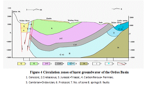
Because the maximum buried depth of carbonate rocks is more than 4000 m and there is no regional fault as the groundwater conduit,it is impossible for the karst groundwater to flow from the western basin to the eastern basin through deep circulation based on the regional flow regime, hydrogeochemical and groundwater temperature regime. Modern karst groundwater circulation only occurs within the karst entity in the vicinity of the basin. According to the buried conditions and circulation features, from the margin to the central basin, three zones can be defined as shown in figure 4.
1). Actively renewing zone (I): This zone mainly distributes in the peripheral area where carbonate rock is outcropped or shallow-buried and karst groundwater has a close relationship with rainwater and surface water. Circulating rate of karst groundwater is high and the circulation depth can be up to 800m below local erosion basis. Karst groundwater temperature is 10-45℃, groundwater age is less then 10 000 years and groundwater type is dominated by bicarbonate with TDS content less than 1g/l. This zone is the main site for current groundwater exploitation
2). Slowly renewing zone (II): This zone is buried 800-1800 m deeper below local erosion surface with low groundwater renewing rate. Groundwater temperature in this zone is 40-75℃ and TDS ranging from 1.2 to 5.0g/l and dominated by the type of Cl·SO4 and is of over 10 000 years old. Karst groundwater within this zone has not been exploited currently in most areas except where geothermal water being exploited.
3). Stagnant zone (III): the burial depth of this zone is 1800-2500 m below local erosion surface where groundwater is the connate water in petroleum and gas fields. Temperature, TDS content and chemical type are 90-105℃, 10-50g/l and chloride type respectively.
3.2 Groundwater circulation and evolution in CAS
Groundwater
in CGS is mainly recharged by precipitation. Controlled by the higher
topography than surrounding areas, there is no lateral recharge from the
surrounding groundwater systems except in the eastern foothills of
However, south basin has worse recharge conditions and can not receive direct recharge from rainwater where the Cretaceous aquifer is underlain by 100m thick loess and 20m Neocene
 |
mudstones,.
Groundwater circulation
and evolution in CGS is mainly controlled by surface divides, recharge
conditions and drainage systems. Piezometric surfaces of the groundwater in CGS
are similar to ground surface in that the ground divide is also the divide of
shallow groundwater and the ground depression is the discharge zone of shallow
groundwater. The CGS can be divided into 5 independent groundwater systems by 4
surface divides, among which the
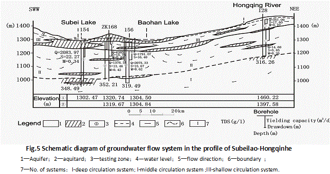
separates the basin into the south and north parts with distinct features of circulation. In the north, groundwater receives recharge in the divides, flows to rivers (lakes). In the south, groundwater receives recharge at the aquifer outcropping area and flows to rivers. In order to well understand groundwater circulation and evolution on the basis of newly acquired hydrogeological and hydrogeochemical information, particularly data of water level, isotope and hydrogemchemistry from different depth taken by the Packer systems(Yang et al., 2005), three circulation patterns are summarized, that is, local, immediate and regional circulation systems as shown in Fig.5.
Shallow circulation system (III): This system occurs between ridges and nearby rives or lakes with circulation depth of 100-150m. This system is characterized by fast circulation, high renewal capacity and good water quality. Generally, groundwater age is less than 1000 years. For example, , CFC model ages of groundwater samples at 100 m and 170 m below the land surface in Borehole 14 are 14 years and 40 years respectively (Yang et al., 2004).
Intermediate circulation system (II): Compared with the shallow circulation system, intermediate circulation system is involved with more extent and deeper with the maximum circulation depth of up to 300m. The middle-scaled river and larger lakes are the main discharge zones. Groundwater age varies between several hundreds to several thousands years with majority younger than 1000 years.
Regional circulation system (I): In this system, groundwater flowing rate are extremely low and the circulation depth is between 500-1000m below land surface up to the lower bottom of Cretaceous aquifer. In the north basin, groundwater quality is good with TDS content less than 1g/L and groundwater age is within 10 000-20 000 years which indicates that groundwater was recharged before Holocene. In contrast, in south basin groundwater quality is bad with TDS content varying from 1 to 3g/L and groundwater age is between 10 000 to 30 000 years.
3.3
Groundwater circulation and evolution in C-JAS and QAS
Fissured groundwater circulation in C-JAS is mainly controlled by the strata-structure, lithology and the relief of the aquifer outcropping areas. Active groundwater circulation zone is only distributed in the aquifer outcropping area or shallowly buried areas with circulating depth of 50-1000m. The weak circulation zone is between 100-300m and the stagnant zone is below 300m. Groundwater in Quaternary Salawusu formation can receive direct recharge from precipitation and flow to nearby lakes. Due to short circulation path, groundwater age is within 20 years using CFC dating methods.
4 Groundwater Resources and its Potential
Groundwater resources evaluation in the Ordos basin by water balance and numerical simulation methods shows that the amount of total recharge resources, available resources and the current exploitation are 10.148 ×10⁹ m3/a ,5.123×109 m3/a and
1.036×10⁹ m3/a respectively and the amount of potential resources in the Ordos basin is 4.088×10⁹ m3/a(Table 1 and Figure 2).
In KAS, the amount of total natural resources are 1.345 ×10⁹ m3/a and the amount of available resources is 1.076×10⁹ m3/a. the current mining rate is 0.198×10⁹ m3/a,and the potential is 0.879×10⁹ m3/a. The greatest potential is in the Tianqiao spring domain and the Fuping-Wanrong system.
In CAS, the
amount of total natural resources are 7.133 ×10⁹m3/a and the amount of
available resources is 3.628×10⁹
m3/a. The current mining rate is 0.729×10⁹ m3/a and the
potential is 2.899×10⁹ m3/a.
The greatest potential area is located in the north of CGS and Jingbian of
Shaanxi province and bordering area of
In C-JAS and QAS, the amount of total natural resources are 1.67×10⁹ m3/a and the amount of available resources is 0.419×10⁹ m3/a. The current mining rate is 0.109×10⁹ m3/a and the potential is 0.31×10⁹ m3/a. The greatest potential area is located in desert covering area and large river valleys.
Table 1 Groundwater resources in the
|
Groundwater system |
Area (104km2) |
Natural resources |
Available Resources |
Current mining rate |
potential |
|
KGS |
7.35 |
1.345 |
1.076 |
0.198 |
0.879 |
|
CGS |
13.21 |
7.133 |
3.628 |
0.729 |
2.899 |
|
CQGS |
6.47 |
1.670 |
0.419 |
0.109 |
0.310 |
|
Total |
27.03 |
10.148 |
5.123 |
1.036 |
4.088 |
5 Conclusions
1. The Ordos basin is dominantly a large scale synclinal sedimentary basin composting of different kinds of rock from Mesozoic to Paleozoic era. Based on the water-bearing media and hydraulic features, the groundwater system of the Ordos basin can be divided into Karst Aquifer System of Carmbrian-Ordovinian carbonates (KAS), the Cretaceous Aquifer System (CAS) and the Carbonate-Jurassic and Quaternary Aquifer System (C-JAS and QAS). All of these aquifer systems are superimposed together vertically and contacted laterally. As the result of erosion locally by the drainage system, there is a close hydraulic connection among these aquifer systems, which makes the Ordos basin a semi-open groundwater basin.
2. Groundwater is of meteoric origin. Groundwater circulation and evolution are mainly controlled by geomorphology, drainage system and
paleo-environment. Generally, groundwater flows from the recharge area to the Yellow river and its tributaries. Circulation depth is different in different systems. The maximum circulation depth is 1200-1800 m,500-1000 m and less than 300m below the local erosion basis surface for KAS,CAS ,C-JAS and QAS respectively. Knowledge about the groundwater circulation and evolution will benefit to understand the attributes of groundwater resources, to evaluate the groundwater resources and protect the eco-environment.
3. Groundwater resources are rich in the Ordos basin and the current mining rate is low. With the development of the national energy base, large amount of groundwater will be exploited progressively. In order to make sustainable development and prevent geo-environmental problems, rational development strategies are made to meet the need of sustainable development of resources, environment and society.
Acknowledgements
This work was supported by grants from the Chinese Geological Survey Plan (No. 1212010331302) and IAEA Technical Cooperation Project (CPR/8/012-017). Dr. Yin Yueping, Dr. Wu Xuanmin and Dr. Wen Dongguang are deeply appreciated for their support. We are very grateful to Prof. Wang Deqian, Prof. Liu Fang, Dr. Zhang Maosheng, Dr. Wang Yonghe and our colleagues for their valuable comments.
References
[1] A.L. Herczeg, T.Torgersen, A.R.chivas and
M.A.Habermehl, Geochemistry of groundwater from the great artesian basin,
[2] Brinkmann, P.J., Heinl M., and Thorweihe U., 1987, The Nubian groundwater system in north-east Africa, in developments in the analysis of groundwater flow systems edited by G.B. Engelen, G.P. Jones
[3] Cheng Mengxiong, Ma Fengsha, Groundwater resources
and environment,
[4] Hai Xingrui, Ordos Paleokarst Physiographic geology, CARSOLOGICA SINICA, 20(2), p125~129
[5] Hou Guangcai, Wang Deqian, Yin Lihe, Groundwater systems in the Ordos Basin, in groundwater resources and its utilization in the Ordos Basin, Shaanxi Science andTechnology Press, 2004,28-38
[6] Li WenPeng, Zhou Hongchun, Zhou Yangxiao, Typical groundwater flow system in arid northwestern China, Beijing, Seismological Press,1995
[7] Liang Yongping, Hai Xingrui, Shi jia and Yin LIhe, Ordos basin karst groundwater patterns of the system, Acta Geoscientica Sinica. 26(4) p365-369
[8] Liang Youping, Hai Xingrui, Shi Jian, Yin Lihe,
2005, The karst groundwater system in the peripheral area of the
[9] Ling Xueyy, Liao Zisheng, Zhao Shengyong and Su
Xiaosi, Modern hydrogeology,
[10] Liu Pinggui, Liu Zhen, Phreatic water in alluvial-lacustrine deposits formation environment development and utilization Dingbian-Jingbian plain, Survey Science, 2002(2):18-25.
[11] Liu Shian; Huang Zhongxing; Chen Yan; Wang Qi, Formation and distribution of the groundwater in Cretaceous system of the Ordos basin, Journal of Arid Land Resources & Environment, 1996,10(1):1-13
[12] Lu qi, Liu Huifang, YU JIshung, Micro property of rocks and its relation to deep groundwater, in in groundwater groundwater resources and its utilization in the Ordos Basin, Shaanxi Science and Technology Press, 2004,313-326
[13] M.A.Habermehl, Groundwater movement and
hydrochemistry of the great artesian basin,
[14] M.A.Habermehl, The great artesian basin, Australia, BMR Journal of Australian Geology & Geophysics,5, 1980,9-38
[15] Su Xiaosi, Lin Xueyu, Liao Zisheng, Variation of isotope in the Yellow River along the flow path and its affecting factors, Geochimica,2003,32(4):349-357.
[16] Sun Yongming, Qiao Dongfuang, Groundwater systems
in the
[17] Toth, J., 1963, A theoretical analysis of groundwater flow in small drainage basins. Journal of Geophysical Research, 68(16), 4795-4812
[18] Wang Dachun, Zheng Renquan, Shi Hongyi, Principle
of hydrogeology,
[19] Wang Deqiang, Liu Zhuzhi and Yin Lihe, Hydro-geological structure groundwater circulation groundwater systems analysis the Ordos Basin, Quaternary Science, 2005,25(1):6-13
[20] Xie Yuan, Wang Jian, Yin Yueping, Ordos basin Cretaceous aquifer sedimentology groundwater occurrence-circulation conditions water quality formation and distribution regularity of groundwater concentration, Geological Bulletin of China, 2003,22(10):819-828.
[21] Yang Yuncheng, Hou Guang Cai, and Zhang Maosheng, Applications of Double Packer System to exploration of the groundwater in Ordos basin, Northwest Geology, 2005,38(1):113-115.
[22] Yang Yuncheng, Hou Guangcai, and Ma Sijing, The age and origin of groundwater in the Ordos basin, Northwest Geology, 2004,37(1):97-100.