


Achievements
ISOTOPIC CHARACTERISTICS OF GROUNDWATER AND ITS RESPONSE TO PALEOCLIMATIC CHANGE IN THE HEIHE RIVER BASIN, CHINA
ZHANG Guang-hui, FEI Yuhong , NIE Zhen-long, SHEN Jian-mei, WANG Jin-zhe
(1-Hehai University, Nanjing, 210098;2-Institute of Hydrogeology and Environmental Geology, Chinese Academy of Geological Sciences, Shijiazhuang, 050061, China)
Abstract: The study area is a drought region where is located in the northwest inland of
Key words:
In this paper, it is expounded that the regional climatic change is the main factor to drive the evolution of groundwater recharge and its renewable rate in the Heihe River Basin of Northwest China on the environmental isotopic data and paleoclimatic research results.
The plain area of the Heihe River Basin in the northwest inland of
Ding Yongjian (1999), Zhang Jie (2004) clarified the spatial-temporal variation characteristics of the precipitation in the
1 Natural Environment and Recharge Condition
1.1 Natural environment
The south boundary of the Heihe River Basin is the Qilian Mountain, the north boundary borders Monolia, the east boundary borders the Shiyanghe River Basin and the west boundary borders the Sulehe River Basin. Its geographic coordinate is the north latitude 37°45¢~ 42°40¢N and the east longitude 97°05¢~102°00¢E with an area of 14.3´104 km2,including the plain area of 5´104 km2(Fig.1).
The Qilian Mountain, where is upwards south of Yinglouxia stream measuring station,is the upper reaches in the Heihe River Basin with the altitude from 1,700 m to 5,564 m,the annual precipitation from 300 mm to 600 mm and the snowmelt water quantity about 4´108 m3/a. The Qilian Mountain area is the main region of the recharge water sources to the plain in the
1.2 Water Cycle Characteristics and Recharge Condition
The upper reaches, the middle reaches and lower reaches are in series of the main stream of the Heihe River and the Beida River(Fig.1),which constitute of “river-groundwater” cycle system of the Heihe River Basin. From the upper reaches to the lower reaches of the

Fig.1 Distribution of the study area
in the Heihe
The profile of groundwater system in the middle reaches of the
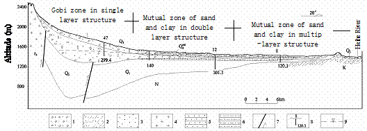
Fig.2 Hydrogeological profile in the middle reaches of the Heihe River Basin
1. sand and gravel; 2. clayey sand; 3. sand; 4. granite; 5. sandstone; 6. sandy shale;
7.faultage; 8. number and depth (m) of borehole; 9. groundwater level
There are 26 main streams from the Qilian Mountain into the plain in the Heihe River Basin, including the main streams of the Heihe River, the Liyuan River and the Beidahe River, with each runoff more than 1,000´104 m3/a. There are small rivers which the runoff is 2.4´108 m3/a. Total average runoff of all rivers is 37.9´108 m3/a over past 50 years. 70%~80% of which infiltrates into the Gobi zone(Fig.2)to recharge groundwater. The mean recharge was 34.7´108 m3/a during the period from 1950s to 1960s and reduced to 26.6´108 m3 in 1990s.
2 Method and Data
From 2000 to 2003, the data of the precipitation, snow melt water, river water and reservoir water, spring water and groundwater with different depths have been systematically obtained(Fig.3) and the dynamic variation of above all water was observed by every month. There are 258 groups of hydrogen and oxygen isotopes samples ( 18O, 2H or D and 3H) and 44 groups of carbon isotopes samples(14C and 13C)collected.
The quantity of the hydrogen and oxygen isotopes sample for measuring analysis is 1 L/group into the airproof glass bottle. The quantity of the carbon isotopes samples is 120 L/group with the NaOH and the BaCl2 into the bottle forming the deposition of the BaCO3, which the air temperature, the water temperature, the water pH value and the alkalinity were all measured on the spot. The 18O/16O data are from the balance measurement with CO2 and the D/H data are from zinc deoxidize measurement, then they were measured by the mass spectrometer. Its standard is in SMOW and the analysis precision of δ18O is ±0.1‰ and of δ18D is ±1.0‰. The 3H data are from the electroanalysis for collection and measured by the coruscate appearance of the lowness fundus liquid,the unit is TU and the analysis precision is ±3TU. The 14C data are from the sample transforming into the benzene, then by the coruscate appearance of the lowness fundus liquid, the unit is PMC, and the analysis precision is ±0.3 PMC. The unit of 13C data is PDB and the analysis precision is ±0.2‰.
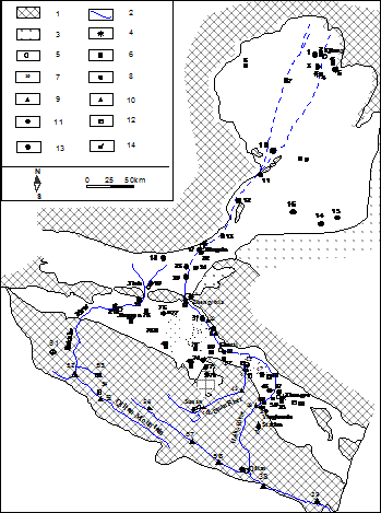
Fig.3 Distribution of sample places in the Heihe River Basin, China
1.mountain area; 2.river; 3.desert area; 4.observing station of isotopes; 5.city or county; 6.sampling place of confined groundwater; 7.number of sampling place; 8.sampling place of shallow groundwater; 9.sampling place of river; 10.sampling place of surface water and groundwater; 11.sampling place of ice-snow water; 12.sampling place of groundwater in divide systems; 13.sampling place of reservoir; 14 sampling place of spring
3 Isotopic Characteristics of Ground-water
3.1 In the
In the Gobi zone of the piedmont plain down the Qilian Mountain in the
Table 1. Isotopic characteristics of groundwater in different zones of the
|
Index |
|
|
|
|
| ||||||
|
The Gobi zone |
The Lower zone |
The Gobi zone |
The Lower zone |
PG in Jinta zone |
PG in Dingxin zone |
PG |
CG | ||||
|
PG |
PG |
CG |
PG |
PG |
CG | ||||||
|
δD (o/oo) |
-47 |
-53 |
-52 |
-56 |
-50 |
-55 |
-62 |
-54 |
-42 |
-46 |
-57 |
|
δ18O (o/oo) |
-9.2 |
-8.4 |
-7.9 |
-9.6 |
-9.1 |
-9.2 |
-9.8 |
-9.2 |
-7.5 |
-5.8 |
-7.6 |
|
H3 (TU) |
33.4 |
62 |
70 |
29 |
49 |
8 |
5 |
25 |
28 |
28 |
6 |
|
14C (PMC) |
68.8 |
99.3 |
84.7 |
78.0 |
84.8 |
93.4 |
38.06 |
55.7 |
125.3 |
67.7 |
30.4 |
|
pH value |
7.9 |
7.8 |
7.5 |
8.22 |
7.82 |
7.49 |
8.35 |
7.48 |
7.6 |
7.78 |
7.84 |
|
TDS (mg/L) |
356.80 |
542.52 |
1440.76 |
384.18 |
716.32 |
949.3 |
539.45 |
1231.15 |
2224.00 |
1340.96 |
1004.45 |
Notes: PG= Phreatic Groundwater, CG= Confined Groundwater.
Table 2. Isotopic content of groundwater with different depths in the Zhangye Basin of the Heihe River Basin
|
Groundwater formation and its depth(m) |
3H(TU) |
14C(PMC) |
δ18O(‰) |
δD(‰) | ||||
|
Range |
Mean value |
Range |
Mean value |
Range |
Mean value |
Range |
Mean value | |
|
Phreatic groundwater 0~40 m in depth |
52~165 |
104 |
71.45~114.02 |
87.93 |
-8.0~-7.5 |
-7.7 |
-52~-50 |
-51 |
|
Confined groundwater 40~100 m in depth |
23~164 |
81 |
62.51~112.04 |
83.34 |
-9.2~-7.9 |
-8.4 |
-56~-53 |
-54 |
|
Confined groundwater more than 100m in depth |
2~76 |
36 |
30.42~74.89 |
58.49 |
-10.0~-9.3 |
-9.7 |
-59~-55 |
-57 |
In the hydrogological profile of the Zhangye Basin,there are three groups of water-bearing formation with different depths in the Quaternary where the 3H, the 14C , the δ18O and the δD values are all decrease as the depth increases(Table 2),but only theδ13C value increases.
3.2 in the
In the Gobi zone of the piedmont plain down the Qilian Mountain in the
In phreatic groundwater of the Gobi zone, the Jiuquan Basin, the δ18O value is from -9.6 ‰ to -8.6‰ with the mean value -9.1‰, and the δD value ranges from -57‰ to -45‰ with the mean value -50‰. In phreatic groundwater of the lower zone, theδ18O value is from -9.7‰ to -8.8‰ with the mean value -9.2‰, and the δD value is within the range of -58 ‰ to -52‰ with the mean -55‰. In confined groundwater of the lower zone, the δ18O value is from -10‰ to -9.6‰ with the mean value -9.8‰, and the δD value is from -63‰ to -60 ‰ with the mean -62‰.
In the Jiuquan Basin, theδ18O and the δD of phreatic groundwater are all near to those of confined groundwater. The 3H value are all less and the SiO2 content more in phreatic groundwater and confined groundwater, which is quite different from that of the Zhangye Basin(Table 1) because the groundwater recharge source of the Jiuquan Basin is different from that of the Zhangye Basin. In the
3.3 in the Lower Reaches
In the Jinta area of the lower reaches, the
In the Ejina Basin where is the lower zone of the lower reaches of the
4 Recharge and Renewable Charact- eristics of Groundwater
The groundwater is the product forming in the geological history period and its isotopes record the past climatic status, which shows the property and the intensity of groundwater recharge sources. The Fig.3 from 48 groups of the groundwater isotopic data by the statistical frequency distribution of the 14C content- shows that the period with greater frequency was the main recharge period of groundwater and the precipitation is more considerable. The period with less frequency is less was the non-main recharge period of groundwater. In the non-main recharge period, the precipitation and the recharge were all less and the climate was dry.
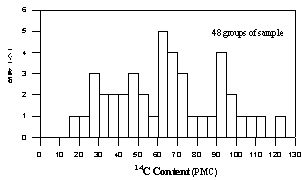
Fig.3 Distribution of the statistical frequency on 14C of groundwater by 5 pmc in the Heihe River Basin
The recharge rate is related with the statistical frequency of the groundwater 14C samples and is inverse ratio with the square of the departure value of the deuterium from atmospheric precipitation line because the information of the groundwater recharge has been recorded in the groundwater isotopes occurring in the geological historical period (Fig.3). Therefore, Fig.4 has been given by above relationship from Allison et al.(1978)and it shows the evolution process of the groundwater recharge rate in the plain of the
The results of the statistics frequency of the groundwater 14C samples in the Fig.3 are that the high frequency of the groundwater 14C content appears from 25% to 55%, from 60 % to 75% and from 90% to 95%, corresponding to the water-abundant periods respectively from 8,000 a BP to 4,500 a BP, from 3,500 a BP to 2,500 a BP and last 1,000 years (Zhang Guanghui, 2003).


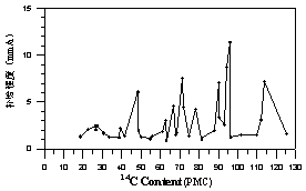
Fig.5 Relationship between 3H and 14C content
in the
M-age: mixing water; P-water: present water; O-water: water of older age; Y-water: water of younger age
During last 10,000 years, there are three main phases of the recharge from the results of the Fig.3 and Fig.4, which are corresponding to the water-abundant period and the warm period of that time.
Groundwater in the plain of the
In the plain of the
The age of confined groundwater is more than 1,000 years in the Jiuquan Basin and is less in the
5 Response of Groundwater Recharge to Paleoclimatic Change
5.1 Evolution of paleoclimate and paleohydrology
The development and the disappearance of the turves were the results of climate change from wetness to aridity and were closely related with the precipitation, the river runoff and the groundwater level. Cao Xingshan (1996) held that there were five stages of forming the turf layers in
It has been proved by the ice core recording the change of the paleoclimate in the study area that the stable warm-wet stage occurred from 7,200 a BP to 6,000 a BP (Shi Yafeng et al., 1995), at that time the precipitation was plentiful, the surface runoff was abundant, the lakes in the lower reaches outspread continuously and the recharge to groundwater was surfficent. In the Ejina Basin of the lower reaches of the Heihe River Basin, the total dissolved solids (TDS) of confined groundwater which was formed during the period from 8,000 a BP to 5,000 a BP is low and the water quality is better.
Since the late stage of the Holocene, the climate has been continuously dry so that the area of the lakes and the marshland has reduced in large extent, the pasture vegetation has rapidly degraded and the land has become the desert in the
In the past 500 years, the air temperature rose by 1.0℃ or 1.2℃ in the Qilian mountain, as a result, the glacier area reduced by 33% to 46%, the precipitation reduced by 50 mm to 80 mm,the glacier melt water reduced by 35% to 46% and the land evaporation increased by 7% (Shi Yafeng et al., 1995). The rainy stages were respectively from 1428 to 1532 AD, from 1622 to 1740 AD, from 1797 to 1865 AD and from 1924 to 1944 AD on the basis of the data of the tree growth ring in the
5.2 Relationship between groundwater recharge and climatic change
It has indicated by the correlative analysis that the correlation coefficient between the groundwater recharge in the plain and the surface runoff from the
The impact ratio of the precipitation from the Qilian Mountain on the groundwater recharge in the plain is about 91% and the impact ratio of the air temperature is 9% in the
Calculated in a century scale, glacier and snowmelt water to recharge the surface runoff will reduce by 10.9% and the surface runoff will reduce by 25.4%, and the groundwater recharge will reduce by 20.5% when the precipitation decreases by 11.6% in an extremely dry year. The glacier-melt water to recharge the surface runoff will rise by 13.6%, the surface runoff will rise by 34.6% and the groundwater recharge will rise by 27.8% when the precipitation increases by 29.5% in an extremely water abundant year (Table 3).
Table 3 Groundwater recharge and corresponding factors variation in the
|
Hydrological conditions |
Precipitation in the Qilian Mountain area(mm/a) |
Evaporation in the Qilian Mountain area(mm/a) |
Variable value of glacier and snow melt water(%) |
Variable value of surface runoff(%) |
Variable value of groundwater recharge(%) |
Ratio accounting for in a period of 1,320 years*(%) |
|
Extremely dry year |
364.8 |
250.8 |
-10.9 |
-25.4 |
-20.45 |
18.88 |
|
Normal year |
412.7 |
259.9 |
0 |
0 |
0 |
20.47 |
|
Extremely water-abundant year |
534.4 |
328.8 |
+13.6 |
+34.6 |
+27.84 |
19.02 |
Notes: Data after Kang Xingcheng et al.,2002; “1,320 years” is the calculation period in Table 3;
6. Conclusion
It has indicated from above researches that the recharge and the renewal groundwater in the plain are closely related to the change of the regional climate in the Heihe River Basin of Northwest China. The age of shallow groundwater is younger and its renewable rate is greater than that of confined groundwater. The renewable rate in the eastern area of the middle reaches is greater than that in the western area and in the fine soil zone is less than that in the Gobi zone down the
References
[1] Allison,G. B,and M.W. Hughes. 1978. The Use of Environmental Chloride and Tritium to Estimate Total Recharge to an Unconfined Aquifer,Aust,J,Soil Res.(16):181-195
[2] Cao Xingshan. 1996. Divide of Quaternary Climate Stages in
[3] Chen Rensheng, Kang Ersi, Yang Jianping et al., Seasonal Groundwater Level Variance in Middle reaches of the
[4] Ding Yongjian, Ye Baisheng, Zhou Wenjuan. Temporal and Spatial Distribution of Precipitation in the Heihe River Basin, Northwest China, during the Past 40 Years [J]. Journal of Glaciology and Geocryology, 1999. 21(1): 42-48.
[5] Gonfiantini R. Carbon Isotope Exchange in Karst Groundwater [J]. In:Karst hydrogeology and Karst Environment Protection,Proceedings. IAHS-AISH Publication. 1988.176:832-837.
[6] Kang Xingcheng, Chneng, Kang Ersi et al. Rebuilding Runoff with Tree year Ring in the Heihe River Baisn over Past 1,000 Years [J].
[7] IAEA. Carbon Isotope Exchange in Karst Groundwater [J]. IAHS-AISH Publication. 1988.176:832-837.
[8] Lan Yongchao, Kang Ersi, Jin Huijun et al. Study on Variation Characteristics and Trend of Mountainous Runoff in the
[9] Shi Yafeng, Liu Chunzhen, Zhang
[10] Xiangsong. 1995. Influence of Climatic Change to Water Resources in the Northwest and North China [M],Jinan: Shandong Science and Technology Press,109-369.
[11] Tamers, M. A. Validity of Radiocarbon Dates on Groundwater [J]. Geophys. Surv,1975.2:217-239.
[12] UNEP. A Survey of Method for Groundwater Recharge in Arid and Semi-arid Regions [M]. United Nations Environment Programme,
[13] Wan Junwei, Liu Cunfu, Wang Peiyi, et al. Principium and Practice of Isotope Hydrology [M]. Wuhan:
[14] Wang Genxu, Cheng Guodong. Variation of Hydrology and Ecological Environment in the
[15] Wei Keqin, Lin Ruifen. 1994. A New Explanation from Oxygen Isotopic Profile of dunde Ice Core in
[16] Wu Xuanmin. Groundwater System in the Ejina Basin, Lower Reaches of he Heihe River, Northwestern China [J]. Hydrogeology and Engineering Geology, 2003. 29(2): 30-33.
[17] Zhang Jie, Li Dongliang. Analysis on Distribution Character of Rainfall over Qilian Mountain and
[18] Zhang Guanghui, Shi Yingxin, Nie Zhenlong. A study of the Ecological Fragility of the
[19] Zhang Guanghui, Liu Shaoyu, Zhang Cuiyun et al., Evolution of Water Cycle and Countermeasure of Water Resources Sustainable Utilization in the Heihe River Basin [J]. Geography and Geo-information Science, 2004a.20(1): 63-66.
[20] Zhang Guanghui, Liu Shaoyu, Zhang Cuiyun et al. Evolution of Groundwater Circulation in the