


Achievements
THE STUDIES OF REGIONAL GROUNDWATER CIRCULATION PATTERN IN THE ARID AREAS
REN Jia-guo1, ZHENG Xi-lai1, WU Qian-qian1,XU Mo2
(1- Institute of Environmental
Science and Engineering, Ocean University
of China,
2- National Lab of Geo-hazard Prevention & Geo-environment protection,
Chengdu University of Technology,
Abstract: Based on the characteristic of “one river one oasis” in arid areas, we take Yerqiang river basin as an example which is the largest irrigated area of Xinjiang in this text, and point out the regional water circulation pattern through the analysis of 60 groups of isotope data in the basin; In virtue of phreatic evaporation data analysis of different soils, we study the regularity of phreatic evaporation, having solved the research of main consumption path of groundwater and improved the appraisal precision of water resources. In light of calculation to predict the amount of regional transformation water resources, offering scientific basis for appraising water resources and rational distribution in arid area, and new method for the studies of regional groundwater circulation.
Keywords: Arid Area,Regional Groundwater,Circulation Transformation Pattern
Introductin
In the 21st century, the water resources crisis occurs in more and more arid areas [1]. The obvious characteristics of water resources in arid area are rare precipitation, strong evaporation and uneven resources allocation. As stable water resources supply, the function of the groundwater is more and more obvious. People place hope on groundwater resources and exploit day by day under the situation of short of water resources in arid area. However, groundwater is different from other subterranean resources. The groundwater, atmospheric precipitation and surface water form a mutual transformation and interdependent system that can't be separated. So three-types water should be considered in unison in study of the distribution regularity[2]. Only investigating the mutual transformation relation among atmospheric precipitation, surface water and groundwater, we could master and make use of water resources regularity correctly, develop and utilize water resources effectively. Ignoring water transformation relation and appraising water resources unilaterally will result in distorted result inevitably[3].
Surface water of Yerqiang river basin stems from melted water of ice and snow in south of Kunlun Mountains, groundwater accept side oozing supply of mountain and surface water oozing supply in plain district mainly. Because the plain district is influenced by reservoir seepage, field seepage, trench seepage, riverbed seepage and evaporation, its transformation pattern is complicated. It is necessary to take further investigation to bear out regional water circulation mechanism.
So we carry out the research of regional water circulation pattern in arid area to find out the transformation pattern of three-types water in this text, calculate transformation resources quantity to confirm transformation relation and offer scientific basis for developing and utilizing water resources rationally. It is not only propitious to develop water resources fully, but also direct significance for developing and utilizing water resources in other similar arid areas[4].
1 Hydro-geological General Situation in This District
Yerqiang
River Basin of Xinjiang lies in the north of
The loose level of the Quaternary in the district distributes in the diluvium fan of Ye River and Ti River and their downriver diluvium plain and desert district mainly, its distributing area is very wide. While groundwater in plain district accepting lateral groundwater runoff supply, strong water transformation and alternation take place with surface water and atmosphere at vertical direction, which shows as seepage of surface water and atmospheric precipitation, discharge and transpiration of groundwater, etc. Regional water circulation is very active.
2 Method of Studies
We put emphasis on the groundwater in this text to analyze the transformations between atmospheric water and groundwater, surface water and groundwater, the transformation mode of three-types water as Fig.1.
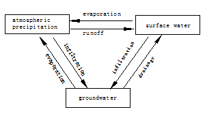
Fig.1 Transformation pattern of three-types water
In allusion to the transformation mode above, analyze the transformation pattern of three-types water through isotopic technique of water environment and phreatic evaporation test.
The isotopic information of surface water and groundwater can judge the transformation relation between atmospheric water and groundwater, surface water and groundwater in different areas, divide hydro-geological unit in plain district, analyze the origin and formative conditions of groundwater, confirm the age and kinetic mechanism of groundwater, etc[5]. Phreatic evaporation is the main drainage path of groundwater, we take out sensitiveness analysis about the influence of different soils, different depths and atmospheric evaporation abilities in this text.
Practice has proved that above-mentioned means are practically feasible in study of the transformation regularity of groundwater circulation in this text[6], offering new method for study of the water resources transformation in arid areas.
3 Analysis of Transformation Pattern
3.1 Isotopic data analysis of regional water circulation transformation
The isotopic composition characteristics of groundwater in study area show the relation of δD and δ18O (Fig 2). It is not difficult to find that isotopic contents of groundwater generally deviate from waterline of mountain area and lie above its nearside in picture, mainly falling in the range of isotopic composition of river, they distribute roughly along a evaporation line, the gradient of which is 7.02. The isotopic composition data points of different positions also basically distribute on the evaporation line of groundwater, they are very difficult to be separated from the data points of groundwater completely. It indicates that groundwater in study area does not origin from atmospheric precipitation seepage directly, but from the seepage supply of surface water (including river, channel water, field canal irrigated water).
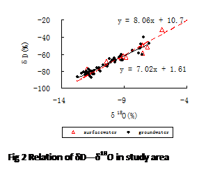 As can be seen from distribution condition of dispersed points in fig2,
groundwater isotopic composition can be divided into two groups on the whole:
Group I distributes along the underpart of evaporation line, heavy isotopes are
relatively deficient, it belongs to groundwater of Ye river. Group Ⅱ distributes along
the upside of evaporation line with the direction of collected heavy isotopes
which belongs to
groundwater of Ti river. It shows that the study area is divided into two
hydro-geological units of Ye river and Ti river. While flowing through diluvium
Gobi gravel, the local phreatic depth is
great, stratum seepage and runoff conditions are good, the river leaks along
the riverbed vertically and supply groundwater abundantly. Some rivers with
short flow nearly all leak and lost here. The isotopic characteristics of water
samples in this district and in the mountain are very close. Both sides of Bank
all demonstrate isotopic characteristic of river obviously, more far it leaves
from the bank , the richer heavy isotopes are. From the beginning of Kaqun
canal to downstream plain district, heavy isotopes are rich gradually with the
influence of evaporation.
As can be seen from distribution condition of dispersed points in fig2,
groundwater isotopic composition can be divided into two groups on the whole:
Group I distributes along the underpart of evaporation line, heavy isotopes are
relatively deficient, it belongs to groundwater of Ye river. Group Ⅱ distributes along
the upside of evaporation line with the direction of collected heavy isotopes
which belongs to
groundwater of Ti river. It shows that the study area is divided into two
hydro-geological units of Ye river and Ti river. While flowing through diluvium
Gobi gravel, the local phreatic depth is
great, stratum seepage and runoff conditions are good, the river leaks along
the riverbed vertically and supply groundwater abundantly. Some rivers with
short flow nearly all leak and lost here. The isotopic characteristics of water
samples in this district and in the mountain are very close. Both sides of Bank
all demonstrate isotopic characteristic of river obviously, more far it leaves
from the bank , the richer heavy isotopes are. From the beginning of Kaqun
canal to downstream plain district, heavy isotopes are rich gradually with the
influence of evaporation.
3.2 Analysis of the phreatic evaporation regularity
Phreatic evaporation is the main form of shallow layer groundwater and atmospheric water transformation naturally, it is an important link of the three-types water transformation[7]. Studying the characteristic of phreatic evaporation regularity in this district and recognizing phreatic evaporation are the key to improve the calculation precision of water resources, having solved the research of main consumption path of groundwater.
3.2.1The influence of surface water evaporation intensity to phreatic evaporation
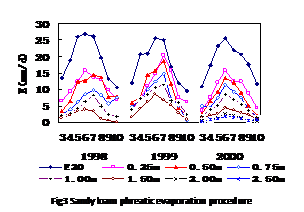 The
test adopts E20 that behalfs diameter 20cm evaporation dish as evaporation quantity to
reflect the relation between different phreatic evaporation capacity and E20.
Fig3.indicates: phreatic evaporation linearly increases with E20
under the condition of light phreatic depth and surface evaporation in march to
October from
1998 to 2000, and it nonlinearly increases with E20 in the condition of large phreatic
depth, and is restricted by the maxi phreatic evaporation; When phreatic depth
increases to 2.5m deeply,
it is never restricted by surface evaporation influence and approaches to zero
with phreatic depth increasing. So phreatic evaporation is affected by surface
evaporation within definitive range, its impact reduces gradually when phreatic
depth exceeds a
The
test adopts E20 that behalfs diameter 20cm evaporation dish as evaporation quantity to
reflect the relation between different phreatic evaporation capacity and E20.
Fig3.indicates: phreatic evaporation linearly increases with E20
under the condition of light phreatic depth and surface evaporation in march to
October from
1998 to 2000, and it nonlinearly increases with E20 in the condition of large phreatic
depth, and is restricted by the maxi phreatic evaporation; When phreatic depth
increases to 2.5m deeply,
it is never restricted by surface evaporation influence and approaches to zero
with phreatic depth increasing. So phreatic evaporation is affected by surface
evaporation within definitive range, its impact reduces gradually when phreatic
depth exceeds a
certain range.
 3.2.2 The relation between phreatic evaporation and
phreatic depth
3.2.2 The relation between phreatic evaporation and
phreatic depth
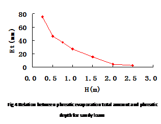
Fig4 indicates: Evaporation capacity changes with different phreatic depth about sandy loam soil in March to October in 2000. in the picture: phreatic evaporation capacity reduces with phreatic depth increasing and approach to zero when it come to certain depth (limitted phreatic depth usually). From the E~H relation picture we can find two obvious breaks. The first break turns near 0.5m which reflects phreatic evaporation is doublely controlled by atmosphere evaporation ability and phreatic depth; the second break takes place near 2.0m which reflects atmosphere evaporation ability decreases, phreatic evaporation is controlled from double control to phreatic depth. Other soils have similar properties.
3.2.3 The influences of different soils to phreatic evaporation
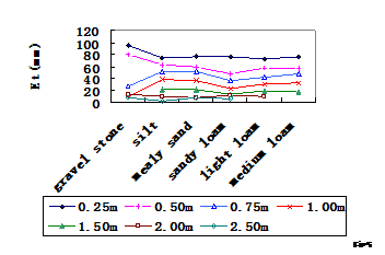 Fig5
indicates: Phreatic evaporation changes with different soils at the same
phreatic depth. X axle represents medium loam, light loam, sandy loam, mealy
sand, silt, gravel stone, soil particle attenuates gradually from left to
right, soil turns from sand into the viscidity. In the picture: we can find
phreatic evaporation capacity reduces gradually under the condition of light
phreatic depth when the soil article are attenuated, the soil changes glued;
And instead phreatic evaporation capacity increases. This agrees with the
regularity that seepage water rate and diffusion coefficient change with soil
percent moisture content for different soils.
Fig5
indicates: Phreatic evaporation changes with different soils at the same
phreatic depth. X axle represents medium loam, light loam, sandy loam, mealy
sand, silt, gravel stone, soil particle attenuates gradually from left to
right, soil turns from sand into the viscidity. In the picture: we can find
phreatic evaporation capacity reduces gradually under the condition of light
phreatic depth when the soil article are attenuated, the soil changes glued;
And instead phreatic evaporation capacity increases. This agrees with the
regularity that seepage water rate and diffusion coefficient change with soil
percent moisture content for different soils.
4 The Calculation of Three-types water Transformation Resources Quantity
We calculates transformation resources quantity respectively in plain district through infiltration coefficient method and balanced computation method in this research.
4.1 Result analysis of infiltration coefficient method and balanced computation method
Surface water is major in the three-types water transformation. The quantity that surface water of mountain area flows into plain district is 75.17×10⁸ m3/a. The transformation quantity of groundwater through seepage of all kinds of surface water is 42.63×10⁸m3/a, which accounts for 56.7% of the total amount of surface water. The atmospheric precipitation in plain district is 7.29×10⁸m3/a, the majority of them turn into gaseous water under extremely arid environment, transforms into groundwater of 0.27×10⁸m3/a directly, which accounts for 3.7% of total precipitation in plain district.
The groundwater resources is 43.46×10⁸m3/a, such natural supply as precipitation seepage and side direction supply are 0.83×10⁸m3/a. The total amount of water resources is 76×108m3/a, the transformation supply quantity of groundwater is 42.63×10⁸m3/a among them, which is the repetition quantity between surface water and groundwater . The results of three-types water transformation are in Tab 1:
4.2 Analysis of transformation resources quantity
Investigating the repeated water quantity is one of the important links that the water resources appraisal. Various kinds of repeated water must be deducted rationally when the water resources is gathered, sequentially to improve the appraising calculation precision of the water resources. The repeated water quantity usually includes: (1) The river seepage supply, which need to be considered while calculating the river and groundwater respectively; (2) The surface water irrigation seepage supply, which need to be considered while calculating the surface water and groundwater respectively; (3) The channel seepage supply, which is
the seepage supply to groundwater along channel while quoting project quotes surface water. (4) The inflow quantity of side direction runoff, which is
|
Transformation pattern |
Transformation direction |
Calculation method |
Transformation quantity |
Total quantity |
|
precipitation to groundwater |
Precipitation→Groundwater |
Infiltration coefficient |
0.27 |
0.27 |
|
surfacewater to groundwater |
Canal drawing→groundwater |
Infiltration coefficient |
24.61 |
42.63 |
|
surface water irrigation→groundwater |
3.22 | |||
|
reservoir→groundwater |
5.33 | |||
|
River drawing→groundwater |
9.48 | |||
|
groundwater to surface water |
groundwater→fountain |
Equalization calculation |
3.88 |
8.84 |
|
Canal drainage→surface water |
4.96 | |||
|
Side direction supply |
groundwater→groundwater |
Equalization calculation |
0.56 |
0.56 |
|
Side direction drainage |
groundwater→groundwater |
Equalization calculation |
0.73 |
0.73 |
|
Phreatic evaporation |
groundwater→atmospheric water |
Equalization calculation |
28.97 |
28.97 |
Tab1 Results of three-types water transformation (108m3)
the repeated quantity between groundwater in study area and that in adjacent areas. (5) The spring drainage quantity, which is the transformation quantity of groundwater to surface water. (6) The outflow quantityof side direction, which is apted to cause repeated water quantity of groundwater and surface water if it drains to river and cause repeated water quantity of adjacent groundwater if it flows to adjacent district. (7) The phreatic evaporation quantity, which is the water quantity that groundwater returns into atmosphere through evaporation.
The calculation regards the groundwater in plain district as emphasis, avoid repeated calculation of river seepage supply while calculating river and groundwater respectively, the same to the repeated calculation of irrigation seepage supply of surface water and channel seepage supply, the results are more accurate and reliable.
The characteristics of three-types water transformation show: the water resources constitution in plain district relies mainly on surface water and groundwater. The general quantity of water resources in plain district is 76×108m3/a, groundwater resources is 43.46×10⁸m3/a, the quantity that surface water seeps to groundwater is 42.63×10⁸m3/a among them, it is the repeated quantity between surface water and groundwater resources ,accounting for 98% of the total amount of groundwater. The atmospheric precipitation in plain district is 7.29×10⁸m3/a, the majority turn into gaseous water under extremely arid environment, its transformation quantity to groundwater is 0.27×10⁸m3/a directly that accounts for 3.7% of the precipitation in plain district. The phreatic evaporation quantity is 28.97×10⁸m3/a , accounting for 66.66% of total groundwater. So we can increase repeated quantity in virtue of three-types water transformation, reducing such invalid evaporation and improving the repeated utilization ratio of water resources.
5 Conclusion
(1)Isotope characteristics indicate that groundwater in the area does not origin from atmospheric precipitation seepage directly, but from the seepage supply of surface water (including river, channel water, field canal irrigated water). And the basin is divided into two independent groundwater circulation systems which accept Yerqiang river and Ti river supply separately.
(2)Phreatic evaporation studies have solved the research of main consumption path of groundwater . We can conclude from test data: Phreatic evaporation quantity is connected with atmosphere ability, soil and phreatic depth. The phenomenon is more obvious when phreatic depth is shallow; With depth increasing phreatic depth reduces and approaches to zero in a certain phreatic depth; There are different evaporation capacity for different soils. generally speaking, evaporation quantity is larger for thin soil and leaning adhesive soil when phreatic depth is shallow; This is the same to the regularity that unsaturated water rate changes with soil moisture content for different soils,to reflect the influences of soil moisture movement parameters to phreatic evaporation.
(3) Isotope technology and phreatic evaporation to research the regularity of regional water circulation is feasible, which offers new methods about regional water circulation pattern studies, guide the regional development and utilization of water resources; and offer scientific basis for the fact that the regional water resources are appraised in amount of transformation resources Calculation of three-types water. offering scientific assurance for regional correct appraisal of water resources in the arid areas.
References
[1] C.R. Anne, R. A. Bruno T.B. mal, J.R. Claude, Is the evoporation from pareatic in arid zones independent of the soil characteristics? Earth & Planetary science, 1998,326:159-165.
[2] Jinlong Zhou,Hudan·Tumuerbai,Xinguang Dong,Transformation relation experiment study among atmosphere precipitation , irrigated water , soil water and groundwater water in Xinjiang plain district(in chinese),Xinjiang: Scientific and technological hygiene publishing house of Xinjiang, 2002.
[3] Zhidong Lei,Water salt monitoring technology report of Yerqiang River Basin (in chinese),Yerqiang River Management of Kashi area in Xinjiang,Water conservancy and power engineering department of Qing-Hua University,1999.11.
[4]
[5]
Thomas
Ibmach, Deep groundwater circulation in the tectonically active area of
[6] PH.Weng, A.Coudrain-Ribstein, A.Talbi and H.Bendjoudi, Groundwater Circulations between Alluvial Aquifer and Underlying Senonian Chalk in the Seine Valley, Phys.Chem.earth(B),1999,24:151-154.
[7] Xiaomin Mao,Limin,Yanli Shen,Phreatic evaporation experiment analysis of Yerqiang River Basin in Xinjiang(in chinese),Geography in arid,1998,21(3):44-50.
[8] Xiaomin Mao,Shixiu Yang,Zhidong Lei,Numerical simulation study of nudation phreatic evaporation of Yerqiang River Basin in Xinjiang (in chinese),Scientific progress of water,1997,8(4):313-320.
[9] J.C.Marchal, D.Etcheverry,The use of 3H and 18O tracers to characterize water inflows in Alpine tunnels, Applied Geochemistry, 2003,18:339-351