


Achievements
A STUDY OF THE GROUNDWATER STORAGE STRUCTURES AND ENGINEERING IN WATER-DEFICIENT AREAS IN NORTHWESTERN
Wu Xuanmin1, Wen Dongguang1, Zhang Fucun2, Zhang Eryong1 and Li Xufeng2
1 China Geological Survey, Beijing 100011, China;
2 Institute of Hydrogeology and Engineering Geology Techniques, China Geological Survey, Baoding 071051, Heibei, China
Abstract: The shortage of water for production and daily life in some villages and towns in the western regions of China is one of the key “bottle necks” constraining the residents from shaking off poverty and developing economy. In order to alleviate the afflictions of these people for water shortage, the China Geological Survey commenced in 1999 a number of projects on groundwater exploration, development and utilization, aiming at supplying drinking water for men and livestock and focusing on the water-deficient villages and towns in western China. This paper is focused on an integrated study of the groundwater storage structures based on the latest data acquired from hydrogeological investigations in the Quaternary Hexi Corridor, Tarim and Junggar basins as well as clastic basins in Xining, Minhe and Huining in the western-central Loess Plateau, and from the cases of water-taking projects already established. The paper presents a detailed illustration of the geological and hydrogeological settings of various regions, the types of groundwater storage structures, their geological structure and origin, formation mechanism of groundwater resources, their enrichment rules, development conditions and examples of water-taking projects, with an attempt to provide references for other water-deficient regions and regions prone to endemic diseases in the exploration, development and utilization of groundwater.
Key words: deficient regions in northwestern China, groundwater storage structure, formation mechanism, model projects
1 Presentation of the Problem
The areas short of drinking water for men and livestock in northwestern China involve Shaanxi, Gansu, Ningxia, Qinghai, Xinjiang and Inner Mongolia, where approximately 130 million people are in lack of drinking water. In some water-deficient villages and towns, men and domestic animals get their drinking water from waterlogged pools and ponds, and some residents have long been drinking highly-mineralized bitter and saline water or high-F and high-As water. In some areas, the residents depend on collecting rain water with “water cellars”, but there is no rain (or snow) water to collect in dry seasons, when they have to fetch water from places several kilometers or even tens of kilometers away. There were even cases in which the villagers had to leave their homes in dry years. Water shortage seriously hindered the improvement of basic daily life and production conditions of the residents, and economy developed slowly, which has become one of the “bottle necks” constraining the development of local people for a “better-off” society. In order to alleviate the afflictions of these people for water shortage, China Geological Survey of the Ministry of Land and Resources commenced in 1999 a number of projects on groundwater exploration, development and utilization, aiming at supplying drinking water for men and livestock and focusing on the water-deficient villages and towns in western China. This paper, based on the latest data acquired from the projects and a great number of engineering cases, and on a summation of studies of various types of groundwater storage structures, probes into the burial and enrichment mechanism of groundwater, with an attempt to provide references for other water-deficient regions and regions prone to endemic diseases in the exploration and development of groundwater.
2 Physiogeography and Hydrogeological Settings of the Study Areas
The study areas mainly include the seriously water-deficient areas such as the boundary areas of the Hexi Corridor, Qaidam and Junggar endorheic basins, the clastic basins in the middle and lower Huangshui River, Qinghai and in central Gansu as well as the mountainous areas in southern Ningxia. The areas belong to typical arid and semi-arid climatic zones. The annual precipitation is about 400 mm in the middle and lower reaches of the Huangshui River, and below 200 mm for most of the other areas. In these areas inland rivers are sparse, the flow changes greatly with the season, and most of the rivers contain bitter and saline water. The unique geological and hydrogeological environment is the main cause for the shortage of drinking water. For example, the boundary areas of the Hexi Corridor and Junggar endorheic basins are formed mostly by Quaternary alluvial-diluvial deposits, the thickness of which is generally several hundred meters, and may reach a thousand meters in places (Li et al., 1996). Quaternary acquifers are widely distribution, but the groundwater levels are deeply buried, and there are a great number of drift boulders of large sizes, making it difficult for the residents to drill wells and fetch water. The middle-lower Huangshui River basins in the center of the study areas and the Xining, Minhe and Huining basins in central Gansu are typical Meso-Cenozoic clastic basins. Besides loess, the exposed strata in the regions are dominated by very thick Tertiary and Cretaceous clastic rocks, with soluble rocks such as carbonate rocks and marble outcropping in some segments on the basin margins. The groundwater in the clastic rocks of the basins is generally too saline to be used (Wu et al., 1998). The people living in the villages and towns on the basins’ border areas have great difficulties in finding water for daily use by men and domestic animals. The Ningnan mountain area in the eastern part of the study areas is one of the areas most deficient in drinking water, where the landform is broken with crossed gullies, and loess is extensively developed. In the e alluvial-diluvial acquifers in the river valley and gully zones, because of constraints by the climatic conditions, the groundwater in most of the sections has a mineralization degree greater than 1 g/L, and also high contents of harmful elements such as F ions. Underlying the loess in the ridge-hills (Liang-Mao in Chinese) area are mainly developed Tertiary mudstone and Cenozoic clastic rocks. As they are located at high elevations, the water content is generally low in the clastic rocks, and groundwater is highly mineralized in most sections, so that they have no value of development and utilization (Shen et al., 1985; Wang et al., 2001).
3 Research Procedure and Techniques
Based on the geological and hydrogeological data and research results by our processors and on an integrated analysis of the regional hydrogeological conditions, the present study adopts high-resolution remote sensing interpretation techniques to select the potential target areas for research centered by the water-deficient villages and towns, where hydrogeological investigations are made on a scale of 1:50,000 or 1:100,000, thereby delineating the sections favorable for groundwater enrichment and suitable for construction of water-supply projects. And then, integrated geophysical explorations will be made to find effective acquifers or groundwater storage structures, and acquire fundamental data on the burial depth and thickness of acquifers or the scale and spatial distribution of the groundwater storage structures. After the ground hydrogeological investigations and geophysical explorations have been completed, the hydrogeologists and geophysicists will discuss together to define the optimal well sites and water-taking schemes on the basis of the latest data. Further, drilling equipment will then be selected for confirmation, and other relate work will be done such as field hydrogeological tests, indoor water quality analysis etc. If the water quality and quantity are of development value, model water-taking projects will be constructed in the water-deficient villages and towns.
4 Features of Groundwater storage Structures in Different Hydrogeological Regions and Cases of Projects
4.1 Groundwater storage structures of quaternary aquifers on margins of endorheic basins
The Quaternary aquifers in the Hexi Corridor and in the piedmont Junggar Basin are deeply buried, especially in the upper and middle parts of the alluvial-diluvial plains, where deep burial zones hundred or several hundred deep are often formed. In the Quaternary strata there are plenty of drift boulders in large size. Previous hydrogeological investigations show that the Quaternary acquifers in a piedmont zone of an endorheic basin contain groundwater of rich quantity and good quality (Li et al., 1996). However, the groundwater is not utilized by the residents owing to lack of geological techniques. As a result, most of the residents have long been suffering from shortage of water both for daily life and for production. To develop and utilize the groundwater in these regions, the key technique is first to define the sections with relatively small burial depths, and secondly to solve the problem of well completion technology in layers with drift boulders.
Massive investigations in this study and case studies of the projects have confirmed that structures such as faults and uplifts are well developed in the piedmont Quaternary strata and their underlying bedrocks in the endorheic basins, and controlled by these structures, there are various types of Quaternary groundwater storage structures buried in the regions. The groundwater storage structures are the best places for constructing groundwater supply wells, because in some sections groundwater levels are relatively shallow owing to the water-resisting effect of faults or uplifts within the structures. According to the origins of the groundwater storage structures (Shen et al., 1985), the burial rules of water levels and the conditions suitable for constructing water-taking projects etc., they can be divided into the basement uplift type, “imbricate” step type, thrusting compresso-shear fault type and the graben type structures.
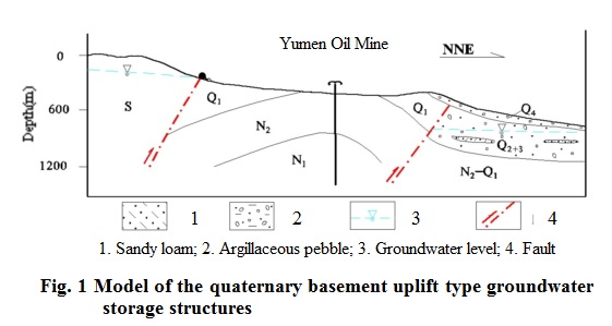
4.1.1 Basement uplift type groundwater storage structures
This type of groundwater storage structures generally occur on the southern margin of the Junggar Basin and in the western section of the Hexi Corridor. For example, in the small piedmont basins on the southern margin of the Junggar Basin and the Chijin Basin, Yumen-Tashi Basin and Aksay Basin in the Sule River valley of the Hexi Corridor, groundwater storage structures are formed owing to water resistance by uplift of the bedrocks underlying the Quaternary.
Geomorphologically, these structures occur in places where between the mountain and plain there is a hilly zone formed by Meso-Cenozoic fault-fold belts. And geologically, the basement folds in the bedrocks underlying the Quaternary have uplifted by the tectonic movement, and the Quaternary acquifers become thinner or even absent (Fig. 1). The mechanism for forming a groundwater level shallow burial zone is as follows: because of the water-resisting effect of the uplifted basement and the thinning of the Quaternary acquifers, the runoff is hindered, so that the groundwater level rises, forming a groundwater level shallow burial zone at the side of the uplift closer to the mountain, whereas at the side towards the basin crossing the uplift belt a deep burial zone is formed.
We have found from field investigations linearly distributed hydrogeological phenomena, e.g. wetland, soil salinization and occasionally overflow of spring water, which have resulted from raise of groundwater level as hindered by underground runoff owing to basement uplift within a groundwater storage structure. In the groundwater level shallow burial zones, Quaternary acquifers contain coarse grains with favorable runoff conditions and the degree of mineralization is generally 0.5 g/L. The water is of good quality, and so they are ideal regions for constructing wells for the supply of drinking water for men and livestock.
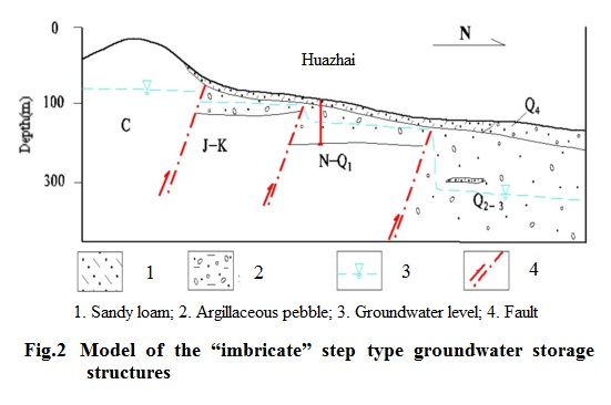
4.1.2 “Imbricate” step type groundwater storage structures
The “imbricate” step type groundwater storage structures in front of the mountain in the southern Wuwei Basin of the Shiyang River valley and in front of Minle Mountain in the Zhangye Basin of the Heihe River valley (east of the Heihe mainstream) are the most typical ones. Geologically they are characterized by the development of several faults of roughly parallel mountains between the mountainous area and the plain area. For example, in the southern part of Zhangye City in the Zhangye Basin of the Hexi Corridor (Fig. 2), beneath the Quaternary System there have developed 3 reverse faults, forming a Meso-Cenozoic inbricate fault zone 2 to 6 km wide. These faults and the Quaternary acquifers have formed the “imbricate” step type groundwater storage structures. Steps are clearly shown in the bedrock relief of the two sides of the fracture, and the thickness of Quaternary sediments also shows a remarkable abrupt change: it is the smallest around the hanging wall of the faults and increases suddenly at the footwall, with a difference of over a hundred meters.
In the fault steps near mountains, the Quaternary loose layers are often of small thickness, and in sections where surface drainage systems are not developed acquifers are only distributed in the vicinity of river valleys (gullies). In the fault steps, when groundwater is flowing towards the plain, it is hindered by faults. Together with the abrupt change in the thickness of the Quaternary acquifers, the groundwater level burial depth near the hanging wall of the fracture is obviously lower than that at the footwall, resulting in an “underground waterfall” phenomenon between the hanging wall and the footwall. The difference in groundwater level is generally about 20 m for fault steps near mountains, and may reach 100 m or even over 200 m in steps away from mountains. Therefore, in this type of groundwater storage structures the groundwater level shallow burial zones are distributed near the hanging wall of a concealed fracture, and so the well sites should be arranged around the hanging wall of a fault zone, or at a distance from the footwall of the fault zone. In these sections the groundwater burial depth is generally below 100 m, and some locally low-lying areas and places with gullies well developed are suitable areas for constructing wells of drinking water. For example, a water-supply well was drilled in 2001 for an immigrant village within an “inbricate” fault step zone in Huazhai Township in southern Zhangye City, in which the burial depth of groundwater level was only about 90 m.
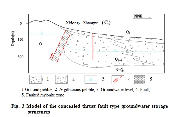
4.1.3 Thrust fault type groundwater storage structures
They are mainly distributed around areas such as Longwangmiao in Zhangye of the Hexi Corridor, Jinfo Temple in Jiuquan and Qianfodong west of Dunhuang, secondly in the eastern segment on the north slope of the Tianshan Mountains, some segments in the Chaiwobao Basin and some piedmont segments in Queletag east of the Tarim Basin. Geologically, they are characterized by the contact of large-scale concealed thrust faults between the bedrocks of the mountainous area and Quaternary basins in the plain area, lacking Cretaceous and Tertiary clastic beds. In the hanging walls of the thrust faults, the Quaternary System is very thin or absent, but increases abruptly to several hundred meters when crossing over the faults. There are two cases of distribution for the shallow burial zones within such structures: In the one case, there is no Quaternary acquifer in the hanging wall of a fault, and the fault is of large scale with a fault mylonite zone several hundred meters wide, so that the fault zone has a good water-resisting property. The hanging wall contains bedrock fissure water. Owing to the water-resisting effect of the faults, there are favorable conditions for the enrichment of fissure water, and the burial depth is relatively shallow. When crossing over the fault zone, the groundwater level burial depth increases abruptly (see Fig. 3), and it is of key importance for solving the problem of drinking water by finding fissure water enriched sections in the hanging wall of a fault. In the second case, at the side of the hanging wall, Quaternary System is developed, but of small thickness, and thickened abruptly in the footwall. Affected by the topographic gradient, a relatively shallow burial zone is formed near the hanging wall, and the burial depth increases abruptly when crossing over the fault. The closer it is to the fractured zone, the greater the burial depth will be. In such type of groundwater storage structures, the well sites should be arranged at some distance from the footwall of a fault. Within the medium to small low-lying gullies (valleys) in the hanging wall of a fault, if the Quaternary System is of certain thickness, and the groundwater level is relatively shallow, generally < 100 m, then a small-scale centralized water supply can be realized for the residents. For instance, in the year 2002, a water-supply well was drilled in a small gully in Ciyaokou southwest of Jinfo Temple, Jiuquan, with the water yield exceeding 1000 m3/d. The thickness of the Quaternary System is 85 m, the groundwater level burial depth is 62 m, and the acquifer is formed by grits and pebbles. The water was of good quality, the degree of mineralization being 0.83 g/L, and it effectively solved the problem of drinking water for local residents and livestock.
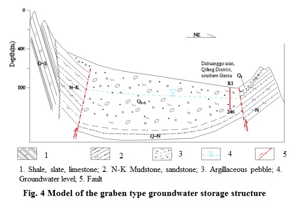
4.1.4 Graben type groundwater storage structures
This type of groundwater storage structures are common on the margins of endorheic basins, e.g. the typical ones formed by water-resistance of the Wenshushan uplift in Sunan County, the Yonggu uplift in Minle County and the Hongshan uplift in Yongchang County together with the Quaternary acquifers. Geologically, the Meso-Cenozoic strata extend beneath the Quaternary piedmont plain, and mostly thrust out of the Quaternary System as thrust-nappe structures in the center of a basin. They stand up in the plain areas, forming hilly areas with relative elevations of 100-200 m. At both sides of the uplifts, secondary concealed faults are formed, and the uplifts and concealed faults separate the basins (Fig. 4), which are not closed intermontane basins but graben type groundwater storage structures. As the structures have separated the basins into two parts, resulting in different sedimentary environments, the thickness of the Quaternary System differs in the basins at the two sides of the uplifts, and groundwater runs from the foreland to the leading edge of the Gobi Basin. At the location of an uplift structure the water level becomes shallow, forming linear spring water in some places. The two basins have a close hydraulic connection. Part of the groundwater overflows to the surface as spring water, and most of which flows out along the margins of the uplift in the form of runoff, forming waterfalls in the basin at the other side of the uplift. In areas with distribution of such groundwater storage structures, we can find relatively shallow burial zones of groundwater in structures on the margins of the uplift, which are the best segments for constructing drinking water wells. Taking as an example, in 2004, two exploratory-production wells were drilled on the south margin of the Wenshushan uplift in northwestern Dahuanggoutan, Qifeng District, Sunan County, Gansu Province, with a water yield of 2200 m3/d of good quality. The groundwater level was buried at about 160 m.
4.2 Groundwater storage structures on margins of clastic basins
The clastic basins refer to the arid basins characterized by Meso-Cenozoic clastic sediments. Among them the beaded basins like the Xining, Huzhu and Minhe bains in the middle and lower Huangshui River in Qinghai and the Huining, Linxia, Zhangchuan, Jingtai and Yongdeng basins in the loess plateau of central Gansu are the most typical, and secondly there are the loess ridge-hills land of clastic rocks in the Ningnan Mountainous area and clastic basins in northern Alxa Plateau in Inner Mongolia. In these basins, the clastic beds are high in salinity, atmospheric precipitation is sparse, evaporation is intensive, groundwater is generally highly mineralized, and bitter-saline water is widely distributed (Wu et al., 1998). The geological conditions for fresh groundwater burial are complicated, and the local residents lack technical support, so that it is difficult for them to find suitable sites or drilling water wells.
The villages and towns surrounding the basins are distant from rivers, and water diversion projects will be too costly to run, therefore some of the residents are in great shortage of water.
Large amounts of hydrogeological investigations and water supply projects show that the key to solving the problem of drinking water for residents in the above-mentioned clastic basins is to search for the sections of groundwater burial and enrichment based on investigations of geological structures. Therefore, it is of important guiding significance to study the spatial distribution of groundwater storage structures in bedrocks and its control on groundwater migration (Liu, 1979). In recent years, a series of groundwater storage structures have been found in the surrounding areas of the aforesaid basins, which can be divided into the nomoclinal, fracture and horst-graben types of groundwater storage structures according to the differences in their formation, reservoir media and water supply conditions. Since 1999, based on investigations and studies of the various types of groundwater storage structures, more than 150 water-supply wells have been drilled for the water-deficient villages and schools in clastic basins, solving the problem of drinking water for some 1 million people.
4.2.1 Monoclinal groundwater storage structures and groundwater enrichment mechanism
Monoclinal groundwater storage structures are common in the boundary areas of the above-mentioned basins, e.g. Laoyeshan, Nanmenxia, Youningsi and Beishan on the north margin of the Xining Basin, Longwangxia on the south margin of the Huining Basin of Gasu and Suhongtu in the Wuliji Basin in northern Alxa Plateau, Inner Mongolia. The most typical ones are the monoclinal confined groundwater storage structure in Taizi Township of Huzhu County of the Xining Basin and the monoclinal phreatic groundwater storage structures in Shina Village on the north margin of the Minhe Basin and in Longwangxia on the south margin of the Huining Basin. An analysis
is made as follows on the geological structure of some typical monoclinal groundwater storage structures and the formation and enrichment of groundwater.
(1) The monoclinal confined groundwater storage structure in Taizi Township of Huzhu County
In the Taizi Township area, there are exposed from north to south Proterozoic marble of the Dongchangou Formation of the Huangyuan Group; crystalline limestone, dolomite and marble of the Beimenxia Formation and Kesuer Formation of the Huashishan Group; Cretaceous purplish red conglomerate, sandy conglomerate, sandstone and sandy mudstone of the Minhe Formation. In the gullies Quaternary talus or loess can be found overlying the bedrocks. As affected by the thrust-nappe tectonism, the Proterozoic dolomite and marble are in direct contact with the Cretaceous System north of Taizi Township. And the strata revealed by drilling in the central part of Taizi Township show that the Cretaceous sandy conglomerate unconformably overlies the (Fig. 5). On the ground surface in southern Taizi Township Cretaceous clastic rocks are seen to be contacted with Quaternary clay accumulations, being affected by the Nanmenxia fault. Good confined groundwater storage structures are formed by the acquifers dominated by Proterozoic dolomite and marble, their overlying Cretaceous sandy conglomerates which serve as impermeable roofs, combined with the water-resisting action of Nanmenxia fault along the groundwater runoff direction.
In the northern part of Taizi Township are exposed extensively Proterozoic domomite and marble of the Beimenxia and Kesuer formations. Kastification is intensive, so that ancient karst caves, solution openings and solution fissures of different ages are well developed on the surface, which are most favorable for retention and infiltration of atmospheric precipitation. During the slow runoff of groundwater from the northern mountain areas to the Huangshui River valley, it is obstructed by the Nanmenxia fault on the basin margin, and consequently groundwater runoff will gather continuously in the Proterozoic domomite and marble. Under natural conditions, karst water in the hanging wall of the Nanmenxia fault overflows to the ground surface in the form of ascending springs. For example, the Niutoushangen spring in Xiataizi Village about 12 km south of Taizi Township is the regional drainage zone of the carbonate rock monoclinal groundwater storage structure. In 2003, the No. GK02 borehole (Fig. 5) was drilled in Zhigou Village, with the well depth being 175 m, the confined water head over 26 m above the ground, artesian discharge 2042.50 m3/d, and degree of mineralization 0.63 g/L.

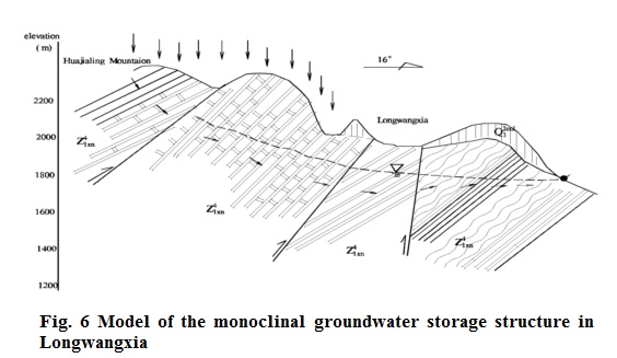
(2) The monoclinal groundwater storage structure in Longwangxia, Huining Basin, Gansu
The Huining Basin is a typical Tertiary depressed basin lying in central Longxi (West Gansu), where Tertiary strata are widely distributed. Tertiary clastic rocks are low in water content and the water is of a high mineralization degree, thus of little water supply significance. Exposed in the surrounding areas of the basin are mainly Sinian metamorphic rocks, dominated by marble, sericitolite quartz schist and sericitolite schist. Longwangxia is located on the north side of Huajialing Mountain on the basin’s south margin, where Sinian marble is widely exposed. On the ground we can see that the marble is dense and hard, pure and fragile, with well-developed structural fissures and solution fissure. In the region, fractured structures are developed, with the Nuanquan large fault on the north side of Huajialing Mountain in the south and the Longwangxia fault in the north. Affected by the Nuanquan fault, there has formed on the north slope of Huajialing a fractured zone about 24 km long and 700-1300 m wide, where low-order plumose fractures and fissures are developed. The lithology on the two sides of the Longwangxia fault is quite different: on the south side marble is exposed, while on the north side the ground is covered by loess, underlain by Sinian sericitolite quartz schist and sericitolite schist (Fig. 6).
The structural fissures and solution fissures in the Sinian marble have good water-storage properties, which, combined with the water-resisting action of the Sinian sericitolite quartz schist and sericitolite schist on the north side of the Longwangxia fault, lay a good geological foundation for the formation of groundwater storage structures (Shen et al., 1985). Atmospheric precipitation infiltrates into marble in the marble outcropping area, and receives recharge from gully flows, underflows and bedrock fissure water in the upper reaches of the gullies. Groundwater runs from SW to NE, is obstructed around the Longwangxia area by Sinian sericitolite quartz schist and sericitolite schist and enriched in marble layers, forming good solution fissure type groundwater storage structures (Fig. 6). Under natural conditions, the main drainage of groundwater is in the form of springs at low-lying areas or contact areas of different lithology in the fault zones, or it turns northeastwards into pore water or fissure water iof clastic rocks.
In 2001, two holes were arranged successively in the Sinian marble exposure area on the south side of the Longwangxia fault, with the completion depth being 200 m and 340 m, and water yield 2300 m3/d and 5000 m3/d, respectively. The construction of these two water-supply wells solved the historical problem of shortage of drinking water for more than 60,000 people living in Huining County and neighboring areas.
4.2.2 Fracture type groundwater storage structures and formation mechanism for fresh groundwater
The fracture type groundwater storage structures can be divided into two types: In the first case, there are concealed faults in the clastic basins or river valleys. If conditions are favorable for groundwater circulation, fresh groundwater may be buried in the fault zones, e.g. the Cretaceous buried fault type groundwater storage structures in Shuangtaying Village, Ledu County, eastern Qinghai. In the other case, on the basin margins or even the watershed areas, the clastic faults buried under loess accumulation may form valuable groundwater storage structures under the infiltration action of atmospheric precipitation. For example, a Jurassic buried fault developed in Tanshan Township, southern Ningxia, is a typical groundwater storage structure in the faulted zone.
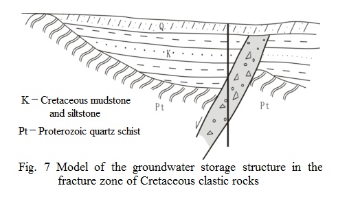
(1) The Cretaceous buried fault type groundwater storage structure in Shuangtaying Village, Ledu County
Shuangtaying Village is situated on the south bank of the Huangshui River, eastern Qinghai. Proterozoic metamorphic rocks are extensively exposed in the southern part of the village, and Cretaceous clastic rocks are distributed in the river valley plain area, covered by Quaternary alluvial-diluvial deposits. Underlying the Cretaceous are Proterozoic quartzite and sericitolite quartz schist, overlain by Quaternary alluvial-diluvial clay and sandy loam, generally 20 m and locally c. 5 m thick. At the Huangshui River valley in the northern part of the village, there is a large NE-trending buried fault, which is proved by geophysical prospecting to obliquely cut the modern valley of the river. An artesian spring outcrops from the Quaternary alluvial-pluvial layers on the northern terrace of the Huangshui River about 3 km northeast of Shuangtaying Village. The spring discharge is about 650 m3/d, and the degree of mineralization is below 1 g/L. Wells have been drilled many times around that spring, and it is found that the groundwater in the wells has a high degree of mineralization. It is thus inferred that the spring water comes from groundwater recharge in the buried fault zone. In order to find drinking water source for the residents, detailed geological-hydrogeological investigations were carried out in the region, and geophysical prospecting revealed that a NE-trending buried fault roughly parallel with the modern valley is developed in the central part of the I-order terrace of the Huangshui River north of Shuangtaying Village. A hole was then drilled. The well is located in the hanging wall of the fault, and it is revealed that the thickness of the Quaternary System is c. 15 m, that of the Cretaceous siltstone and sandstone 60 m, the variegated tectonic clastic rocks of the fracture zone 50 m, and the Proterozoic quartzite and sericitolite quartz schist c. 20 m (see Fig. 7). When drilling into the fracture zone, water gushed from the well. According to layered pumping tests and water quality analysis, in the Proterozoic quartzite and sericitolite quartz schist section, the artesian discharge was 11.41 m3/d, the degree of mineralization 2.37 g/L; while in the variegated tectonic clastic rocks of the fracture zone, the data are 111.97 m3/d and 0.91 g/L respectively. Later, the well was completed in the fracture zone after backfilling of clay. The confined water head was about 12 m higher above the ground, and it became an artesian water-supply well for the hundred residents in the village.
According to further analysis of the hydrogeological conditions, the formation of confined artesian water in the buried fracture zone of Cretaceous clastic rocks is attributed to infiltration and recharge of water from the upper Huangshui River, i.e., at the sections where the Quaternary System overlying the fault is of smaller thickness, or the grains are coarser, the river water recharges the fracture zone through slow infiltration and recharge of the Quaternary System. In the fracture zone, there are good conditions for groundwater runoff, and the lasting circulation of groundwater will dissolve and remove the soluable salts in the fracture zone, so that fresh groundgroundwater storage structures will be formed.
(2) The fault type groundwater storage structure in Jurrassic clastic rocks in Tanshan Township, Ningnan
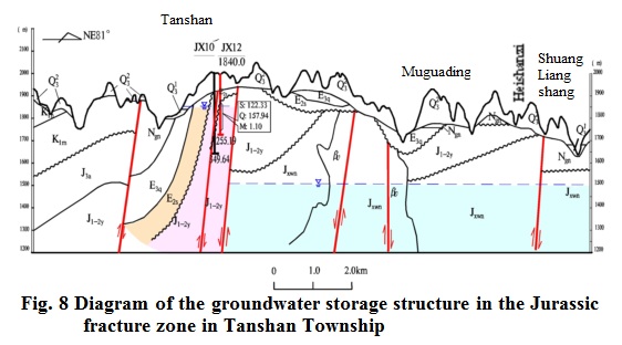
Tanshan Township is situated in the very arid loess ridge-hills region of Ningnan.
Tanshan Village, where the township government office is located, lies in the watershed zone of the nearly N-S longitudinal loess ridge. The ridge has a width below 2 km, with deeply cut gullies on both sides. The dissection thickness is over a hundred m in the eastern gully, and exceeds 200 m in the western gully. The strata developed in the region are dominated by the Quaternary loess, Tertiary-Jurassic mudstone and sandstone etc. The loess is about 50 m thick, extensively overlying the clastic rocks, and Tertiary red mudstone is found exposed on the bottom of the gullies on the east and west sides. At locations of large gully heads, we have found small amount of groundwater flowing out from the contact zone of Tertiary mudstone and loess, the mineralization degree of which is 2.5-4 g/L. The local residents used to dig wells and collect such groundwater as their drinking water sources. The wells would dry up in dry years, and they had to fetch water from distance. In this study, it is found from remote sensing, ground measurement, geophysical prospecting and detailed hydrogeological investigation that there are two nearly N-S-trending buried faults beneath the loess layer in Tanshan Village, and faulting has resulted in a graben fracture zone of c. 500 m in the mudstone and sandstone of the Jurassic Yan’an Formation. Besides, from the hydrogeological phenomenon that a coal mine in the region consumed about 200 m3/d of water (mineralization degree 2.57 g/L) in the Jurassic layer (burial depth 210 m), it was inferred that there may be fresh groundwater in the fracture zone. Drilling was then made in the western part of the village (Fig. 8), and the depth of the borehole was 205 m. The groundwater burial depth was c. 57 m after completion of the well, and the pumping test gave a water yield of 158 m3/d, mineralization degree 1.1 g/L, so that it can be used as a water-supply well for the residents. It is considered after further studies of the latest data of the region that the Jurassic fracture zone buried beneath the loess layer is a typical fracture zone type groundwater storage structure. The compressive water-resisting faults on both sides of the graben have provided a geological basis for the storage and gathering of groundwater in the fracture zones. Although the precipitation amount of the region was low last year, relatively water-enriched zones were formed (Wang et al., 2001) by the continuous gathering of atmospheric precipitation in the Jurassic fracture zone through its lasting and slow infiltration and recharge in the loess layer. As the groundwater has good conditions to migrate in the fracture zone, fresh groundwater is thus available for use by men and livestock in the region.
5 Conclusions and Suggestions
(1) The water-deficient villages and towns in northwestern China are generally located in the areas short of groundwater resources, or belong to the areas where groundwater is of bad quality. However, there is potable groundwater buried in most of the villages and towns. The best way to solve the shortage of drinking water for men and livestock is to explore, develop and use the groundwater by means of modern techniques.
(2) The water-deficient areas are relatively backward in economic development. The local residents not only lack technology but also funds to solve the water-deficient problem by themselves. Therefore, to solve this problem, they need continued support from the state, thereby providing experience and technical support for the areas by setting up state model projects.
(3) In the water-deficient villages and towns, the conditions for groundwater recharge are generally poor, and groundwater resources are limited, so the local government should strengthen management of the model projects. They should follow the “people-oriented” principle and take the guarantee of water for daily life as the primary goal, so as to realize effective and sustainable use of the valuable groundwater resources.
References
[1] Li Wenpeng et al., 1996. Some opinions on the groundwater origin in arid regions of China. Hydrogeology and Engineering Geology, No. 5.
[2] Liu Guangya, 1979. Groundwater in Bedrocks. Beijing: Geological Publishing House.
[3] Shen Zhaoli et al., 1985. Hydrogeology. Beijing: Science Press.
[4] Wang Dachun et al., 2001. Fundamentals of Hydrogeology. Beijing: Geological Publishing House.
[5] Wu Xuanmin et al., 1998. Formation mechanisms of fresh groundwater in the Suhongtu region. Hydrogeology and Engineering Geology, No. 3.