


Achievements
HYDROGEOLOGY AND RESOURCE POTENTIAL OF INTERGRANULAR BURIED VALLEY RIBBON AQUIFERS OF THE CORK AREA, SW IRELAND
Alistair Allen1,2, Ivor MacCarthy1,2, Sergei Kostic3, Dejan Milosevic3
1Dept of Geology, University
College Cork,
+353 21 4271565; e-mail: a.allen@ucc.ie
2Environmental Research Institute, University College
Cork,
3Geofizica-Ing, Dr Ivana Ribara 182/2, Novi Beograd 11070,
Abstract: The
Groundwater from gravels of the Lee Buried Valley, was used for all or
part of its municipal water supply by Cork city continuously from 1879-2001,
collected by means of a shallow infiltration gallery constructed on the north
bank of the R. Lee near the northern margin of the valley. Cork City Council is
considering again using groundwater from this buried valley for the municipal
water supply for
Groundwater from the Lee Buried Valley
has more recently been employed as a source of geothermal energy for space
heating/cooling buildings in
Key words: buried valleys, gravel aquifers; high yield, low enthalpy geothermal energy
Introduction
Intergranular ribbon aquifers of the buried valley type, i.e. deep gravel-infilled valleys formed during periods of reduced sea level usually associated with glacial epochs, are generally not considered to be of great importance in terms of areal extent and groundwater reserves compared to layered, intergranular bedrock aquifers, karst aquifers or alluvial plain aquifers. Consequently, they are usually classified as minor local aquifers, and are often completely ignored in groundwater resource assessments. However buried valley aquifers are much more widespread than currently appreciated and possess significant groundwater reserves. They have been largely neglected because they are less readily identified than other aquifer types, and are often difficult to trace laterally, as they may not necessarily underlie present day valleys. On the other hand, they may be of considerable width and depth, may extend laterally for several tens or even hundreds of kilometres and, since they occur at relatively shallow depths, once delineated, exploitation costs are relatively low.
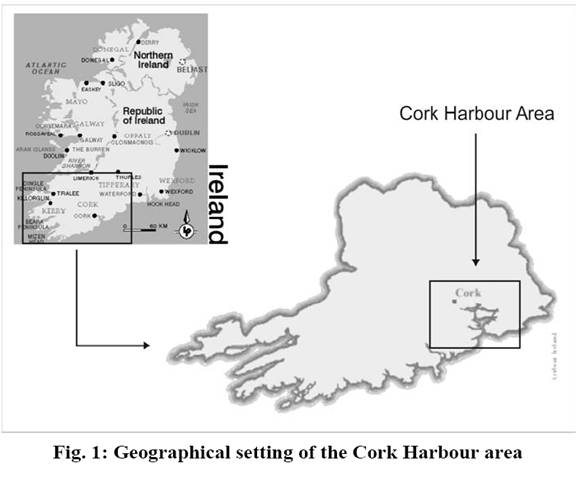
The present investigation arises from an overall assessment of groundwater
resources and quality in the Cork Harbour area of SW Ireland (Allen &
Milenic, 2001; Milenic 2004), an extensive region of about 1,000 km2 (Fig. 1). Ribbon aquifers were
recognised as constituting a major aquifer type in the area, with potentially
considerable groundwater reserves, which are virtually untapped. Several buried
valleys have been identified, and are currently being investigated, partly for
their groundwater potential, and partly because of their potential as a low
enthalpy hydrogeothermal energy source, particularly beneath cities (Allen et
al, 1998; 1999; 2002; 2003; Leahy & Allen, 1998; Allen & Milenic,
2003). This has led to a detailed assessment of their groundwater reserves and
quality, using as a case study the Lee
Buried Valley,
which underlies part of the course of the River Lee, a major Irish river
flowing through
Regional Setting
Cork, situated in the southwest of
Major bedrock and overburden aquifers underlie the
Geology and Geomorphology of the Area
SW Ireland lies within the very
low-grade Rheno-Hercynian fold-thrust terrane of the late Carboniferous
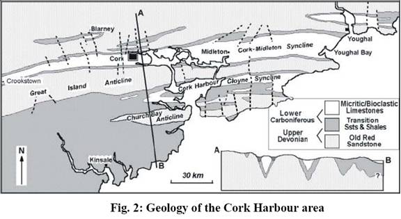
Variscan Orogenic Belt. The geological structure of the area is characterised
by a series of upright horizontal NE-SW to E-W folds, with the anticlines cored
by U. Devonian sandstones and shales and the synclines by massive L.
Carboniferous reef limestones or calcareous shales (Fig. 2). The folded
sequence is cut by E-W thrusts and steep N-S compartmental faults. In the
Formation and Evolution of the Buried Valleys
The topography of the
Prior to the Pleistocene glaciation, intense peneplanation under tropical conditions during the Tertiary period (65-1.8 Ma), resulted in complete erosion of all pre-existing Mesozoic cover in the region, the establishment of a southwards sloping regional topography, a N-S drainage pattern and southerly flowing rivers (Nevill, 1963; see Fig. 4a). Erosion also led to exposure of the underlying Carboniferous limestones, highly fractured due to their massive nature and inability to undergo folding during the Variscan Orogeny, which were subjected to intense karstification under the tropical Tertiary conditions.
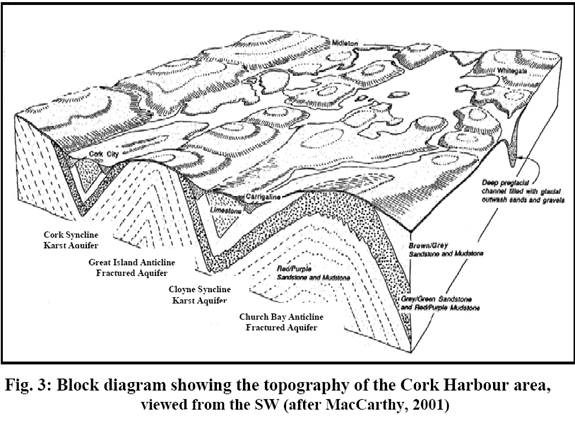
During the Pleistocene glaciation, the Tertiary N-S drainage pattern was truncated by glaciers advancing outwards from the mountainous regions of western Ireland, preferentially exploiting the weaker shales or karstified limestone coring the synclines (Fig. 4b), resulting in the development of a number of broad u-shaped lowlands coincident with the E-W Variscan synclines.
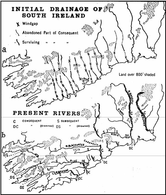
Fig. 4: Drainage patterns of
southern
glaciation (Nevill, 1963)
Superimposed on these u-shaped
lowlands are a series of buried valleys infilled with sand and gravel. At the
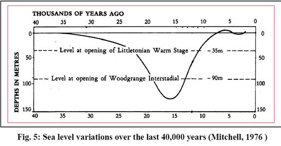
peak of the last glaciation 15-18,000 years ago (Fig. 5), when much of Europe
and North America were covered by ice, sea level fell to an estimated 130m lower than at present (Mitchell,
1976; Pirazzoli, 1996), so subglacial rivers eroded down to the new base level
cutting deep steep-sided gorges in the process. In
When temperatures subsequently ameliorated towards the end of the Pleistocene glacial epoch about 10-12,000 years ago (Fig. 5), the ice sheets started to recede, and sea level began to rise again. The gorges became initially infilled by a succession of fluvioglacial sands and gravels either directly associated with the development of valley glaciers (tills and glacial gravels), or resulting from fluvioglacial outwash as the rivers responded again to changing base level.
Simultaneously, glacial till of variable thickness and lithology was deposited by the receding glaciers Although deposits from earlier glaciations had been eroded, this last glaciation, the Midlandian (26,000-12,000 ka; see Fig. 5), left behind significant deposits of glacial gravels and till (boulder clay), particularly within the synclinal lowlands. Thus, most of the karstified limestone bedrock became buried, sometimes to considerable depth, although locally upstanding resistant limestone pinnacles remain exposed.
There is also evidence that impeded river flow, due to ice dams, moraines
or landslide debris, led to river diversion and deposition of layered,
fine-grained fresh water sediments in ponds or small lakes during interglacial
or interstadial periods. When the ice finally retreated and sea level rose
rapidly, the buried valleys became infilled by fluvial gravels deposited by a
braided river system, and later with alluvial clays and silts. It is likely
that during this period, new river channels were partly cut into rock on the
valley sides as the channels migrated laterally. Marshes, intersected by river
channels, formed the final stage in the evolution of these buried valley
systems, after the rate of sea level rise diminished some 6,000 years ago.
However, the south of
The fluvioglacial gravels play an important role in the groundwater flow regime of this region. Their hydrogeological significance is largely due to their high permeability, thickness and extent. Conversely, the low permeability tills protect the underlying bedrock aquifers, but on the other hand restrict recharge of them.
In the Cork area, the geologically controlled topography consists of alternating ENEWSW to E-W ridges and lowlands, with present day rivers generally flowing eastwards along the synclinal structures, although post-glacial river capture by the entrenched preglacial N-S rivers has led to many of them, e.g. the Blackwater and the Lee, being diverted southwards to cut through anticlinal ridges to reach the sea. As a result the drainage pattern is trellised, with most rivers consisting of E-W and N-S stretches.
Underlying the E-W stretches are buried valleys, which are traceable for 10's of km and extend beyond these
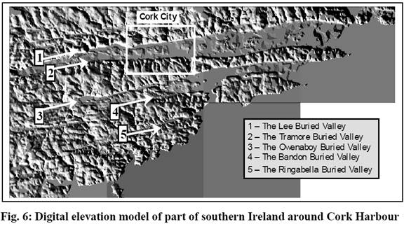
reaches. In the Cork Harbour area, at least four and perhaps five buried
valleys exist (Fig. 6), the Lee, and the Tramore occupying the northern and
southern margins respectively of the Cork-Midleton Syncline; the Owenaboy and
possibly the Bandon, occupying the northern and southern margins of the Cloyne
Syncline; and the Ringabella, which occupies the narrow Ringabella Syncline. To
the north of
Water Cycle in the
The climate of the Cork Harbour area is dominated by the westerly atmospheric
circulation of the middle latitudes and the Atlantic Ocean, which surrounds
Surface run-off (Q) is dependent on topography and estimated at 10% for the synclines (0-30 metres above sea level - mASL) and 75% for the anticlines (up to 200 mASL), respectively. The general water balance equation has been used to calculate effective infiltration (ief.):
ief. = P - (E + Q + DW)
Thus, the calculated value for effective infiltration into the buried valley aquifers is: ief. = 650 mm/year
Types of Aquifer
In the
Intergranular Buried Valley Ribbon Aquifers
The buried valley intergranular aquifers are a series of ribbon aquifers
ranging in width from a few tens of metres to nearly a kilometre. They are
predominantly infilled with variably sorted fluvioglacial gravels. The lateral
extent of several buried valleys in southern
buried valleys
The
Where it underlies Cork city, an abundance
of bedrock outcrops and site investigation borehole data has made it possible
to delineate the extent of the
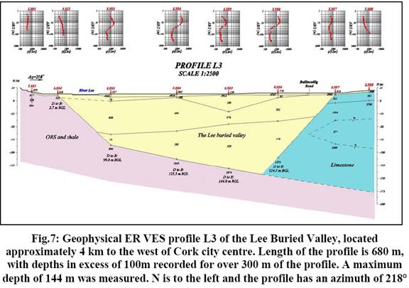
In view of the need for accurate depth estimates, geophysical surveys of
the Lee and other buried valleys in the Cork area were undertaken (Kostic &
Milosevic, 2004; 2005). In all 24 electrical resistivity (ER) traverses or
partial traverses utilising the Vertical Electrical Sounding (VES) technique
were undertaken across six buried valleys. Results indicate depths of the
buried valleys ranging up to 147 m,
with the deepest values encountered in the
In the light of the postulated
geometry, and taking a minimum width of 250 m,
an average depth of 50 m and
a very conservative value for porosity of 0.20, the absolute minimum volume of
groundwater reserves of the
VGWmin = 1.5 x 10⁸ m3.
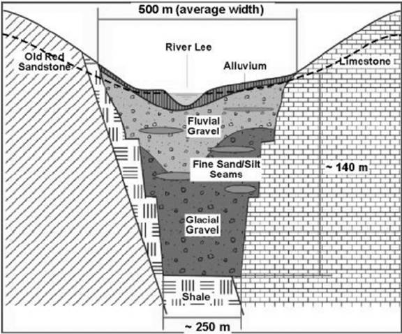
Fig. 8: Schematic
cross-section through the
Other buried valleys in the Cork Harbour
area are narrower and less deep than the
Hydrodynamic Characteristics
Hydraulic conductivity (k) and transmissivity (T) have been calculated using particle size distribution methods from borehole samples, and by pumping tests on wells and an infiltration gallery. For the particle size distribution, the USBR method was used, providing the following mean value for k (Milenic & Allen, 2005): k = 6.87 x 10⁻³ m/s
Pumping test were carried out on several horizontal and vertical water abstraction structures, including an infiltration gallery at Cork Waterworks and a well in the car park at Cork County Hall, which capture the upper levels of the aquifer. For the k and T calculation, the recovery level method (s = f (log t/t-t1)) was used as the most reliable for these examples (Fig. 9). Characteristic values are in the range (Milenic & Allen, 2005):
k = 4.0-4.8 x 10⁻³ m/s
T = 1.22-1.43 x 10⁻² m2/s
Note that the pump test which gave these results was conducted on a well
drilled very close to the southern margin of the
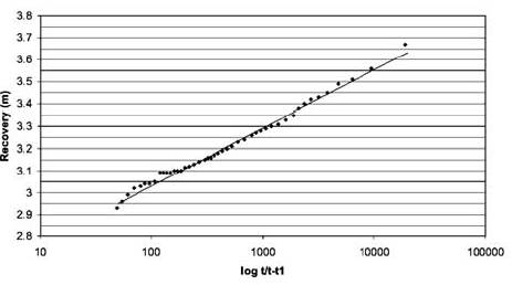
Fig. 9: Water recovery data for the calculation method s = f(logt/t-t1)(Milenic & Allen, 2005)
In view of the excellent correlation of results by the various methods, the above hydrodynamic values may be considered as representative.
Effective porosity for the sand and gravel is estimated to be around 25%.
The porous media is homogeneous in horizontal extent with a slight vertical
heterogeneity. Part of this heterogeneity has resulted from washing down of
fines from the overlying alluvium. Due to the low elevations of the
Cork-Midleton and Cloyne Synclines, particularly in the
Aquifer Recharge and Discharge
Assessment of modes of recharge to the buried valley aquifers suggests that recharge occurs mainly through the following processes (Milenic, 2004):
1 Direct infiltration of rainfall in areas of open gravel extraction pits
2 Percolation through overlying alluvial sediments, ranging in thickness up to 4-5 m
3
Hydraulic connection with various surface streams
including the River Lee -brackish within tidally influenced areas adjacent to
4 Hydraulic connection with the adjacent karst and ORS aquifers
The buried valley aquifers are recharging by direct infiltration only over
very small areas, apart from the Lee Buried Valley,
where large scale sand and gravel extraction is ongoing to the west of
Recharge of the buried valley aquifers from surface streams will only take
place during and immediately after heavy and prolonged rainfall, when the
streams are in spate (Meybeck et al, 1996; Allen & Chapman, 2001). During
dry spells when low flow conditions obtain, groundwater feeds streams, and
discharge/recharge relations between streams and groundwater of the shallow
buried valley aquifers will be dependent on local precipitation and
evapotranspiration totals and on rainfall distribution. That hydraulic
connection exists between the streams and buried valleys is indicated by the
observation that in
The buried valleys are excavated into bedrock, usually at the margins of the synclinal structures, where they have exploited the boundary between the ORS and the limestones. Recharge from the adjacent limestones will be considerable, due to the highly karstified nature of the latter, but recharge will also take place from the fractured ORS.
No natural occurrences of groundwater discharge from the buried valleys
have been observed in the study area, Discharge to streams during low flow
conditions has been mentioned above and this probably represents the most
important natural discharge mechanism. Aquifer discharge takes place
artificially through a number of drilled wells, and also through an
infiltration gallery located at Cork Waterworks. The latter was constructed in
1879 as a source of potable water for
Groundwater Uses
Despite its potential, groundwater in the buried valley aquifers, even
that of the
The present water supply systems for both Cork city and the Cork Harbour
area employ surface water sources, using River Lee water either from Inniscarra
Reservoir 10 km to the west of
Cork city or from an intake point at Cork Waterworks on the western edge of the
city. As mentioned above, Cork city previously derived its water supply from
groundwater of the Lee Buried Valley via an infiltration gallery approximately 0.5 km in length, constructed at a depth
of 5 m in the gravels along
the northern bank of the River Lee, and ending in Cork Waterworks,. This
basically horizontal well, 1 m
in diameter, was lined with porous brick and initially provided the whole water
supply system for
Replacement again of all or part of the surface water sources for the
municipal water supply by groundwater from the
An increasingly important use of groundwater from the buried valley
aquifers in
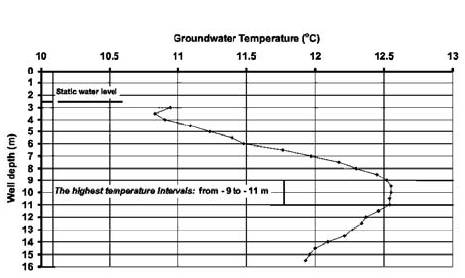
Fig. 10. Vertical temperature
profile determined in a well in central
The nominal available geothermal energy resource (EG) in kilowatts (kw) can be calculated using the equation (Allen et al, 2003):
EG = H x F x DT
where: H = specific heat of water (kJ/kg.℃); F = flux of water [well yield (kg sec-1)]; and DT = temperature reduction in the heat pump (℃). Based on a specific heat of 4.2 kJ.kg-1℃-1, a well yield of 20 kg sec-1, urban groundwater temperatures of 13℃ and a temperature reduction in the heat pump of 8℃, a nominal geothermal heating resource of 672 kW may be available from wells within urban areas (Table 1). When used as a source of heating in a heat pump working at a COP of 4.5:1 the heat produced is approximately 865 kW. This can supply space heating for buildings with a footprint in excess of 12,000 m2 with a peak heating intensity of 70 W/m2 (Allen et al, 2003).
Geothermal heating/cooling systems utilising groundwater from the Lee Buried Valley have been installed in a number of public
buildings in
The Docklands area is located to the east of
The recognition that large abstractions of groundwater for geothermal energy may have
an impact on the
saline/freshwater interface beneath the docklands area and may also have
consequences for deep boreholes in
Conclusions
Intergranular buried valley gravel aquifers are important groundwater bodies which may have widespread distribution in northern latitudes affected by the Pleistocene glaciations. Many European buried valleys are thought to have formed during a particularly cold spell in the Late Pleistocene about 15,000-18,000 years ago, which led to a drop in sea level to about 130 m lower than that of the present day. In southern Ireland, the courses of the buried valleys were controlled by the pre-existing bedrock structure, which was exploited by the glaciers as they spread out from their mountain sources, so in the Variscan Orogenic Belt of SW Ireland the buried valleys tend to trend W-E or WSW-ENE, and occupy the margins of lowland areas defining synclinal fold structures.
In the
Detailed hydrogeological investigations of the Lee Buried Valley, the best
known of these palaeorivers, indicates a length of at least 60 km, a width of 500-750 m and depths up to in excess of 140 m. Groundwater reserves for the
aquifer are at an absolute minimum 1.5 x 10⁸
m3, and groundwater yields range from 500-1500 m3sec-1. Hydraulic conductivities are about 5 x
10-3 m/sec, and
transmissivities may be of the order of 0.25
m2/sec. The River Lee is tidal through Cork,
and groundwater levels fluctuate with the tides indicating a hydraulic
connection between the river and groundwater, which is only a few cms below
ground level in central
Groundwater in these buried valley aquifers is severely underutilised.
Although in the past groundwater was abstracted via an infiltration gallery for
the
References:
[1] Allen, A.R. (2006) Urban groundwater problems in Cork city, SW Ireland. In: Howard, K. (Ed) Groundwater Management in Urban Areas. Balkema (in press)
[2] Allen, A. R., Chapman, D. V. (2001) Impacts of afforestation on groundwater resources and quality. Hydrogeology J., 9, 390-400
[3] Allen, A.R, Leahy, L., McGovern, C., Connor, B.P., O'Brien, M. (1998) Assessment of the thermal potential of groundwater in gravels underlying the floodplain of the Lee,
[4]
[5]
Allen, A.R., MacCarthy, I.A.J., Milenic, D., Davis,
T., Higgs, B. (2002) Buried valleys in the
[6]
Allen, A.R. McGovern, C., O'Brien, M., Leahy, L., Connor, B.P. (1999) Low
enthalpy geothermal energy for space heating/cooling from shallow groundwater
in glaciofluvial gravels, Cork, Ireland. In: Fendekova, M., Fendek, M. (Eds) Hydrogeology and Land Use Management. IAH,
[7]
Allen, A.R., Milenic, D (2001) Preliminary Assessment of Groundwater
Resources and Groundwater Quality in the Cork City/Harbour
[8] Allen A.R., Milenic, D (2003) Low enthalpy geothermal energy resources from groundwater in fluvioglacial gravels of buried valleys. Applied Energy, 74, 9-19
[9]
Allen, A.R., Milenic, D. (2006a)
Groundwater Vulnerability Assessment of the
[10] Allen, A.R., Milenic D.
(2006b) Fractured Old Red Sandstone Aquifers of the
[11] J., Sharp, J.M. (Eds) Groundwater in Fractured Rocks, IAH Special Publication, Balkema (in press)
[12]
[13] Davis, T., MacCarthy, I.A.J.,
Allen, A.R., Higgs, B. (2006) Late Pleistocene-Holocene Buried Valleys in the Cork
[14] Leahy, K.L., Allen, A.R.
(1998) Assessment of the thermal potential of groundwater in gravels underlying
the Lee valley,
[15] MacCarthy IAJ (2001) The
geological history of
[16] Meybeck M, Friedrich G, Thomas R, Chapman DV, (1996) Rivers. In: Chapman DV, (Ed) Water Quality Assessments. 2nd Edn, E & FN Spon, Ch 6, 243-318
[17] Milenic D (2004) Evaluation of
groundwater resources of the
[18] Milenic, D., Allen, A.R.,
(2004) Brackish Water Intrusion Problems in Cork
City and Harbour, SW
Ireland. In: Proceedings 18th
Salt Water Intrusion Meeting.
[19] Milenic, D., Allen, A.R., (2005) Buried Valley Ribbon Aquifers - A Significant Groundwater Resource of SW Ireland. In: Bocanegra, E.M., Hernández, M.A.,
[20] Usunoff, E.J. (Eds.)
Groundwater and Human Development, Balkema,
[21] Mitchell, G.F. (1976) The
Irish landscape. Collins,
[22] Nevill, W. E. (1963) Geology
and
[23] Pirazzoli, P.A. (1996) Sea level changes-the last 20,000 years. John Wiley & Sons