


Achievements
SUSTAINABLE DEVELOPMENT AND GROUNDWATER OF MONGOLIA
N.Batsukh*, N.Buyankhishig*, D.Ouyn*, Ya.Boldbaatar**
*- Mongolian University
of Science and Technology,
**- Water Authority
of
N.Batsukh
e-mail: nbatskh@must.edu.mn
Tel.: +976 -11-315650
Abstract:
Key words: water supply, anthropogenic factors, waste water treatment, restoration, quality standards, monitoring
Introduction
Water is special natural resource
because it is a source of all world life and main factor of social sustainable
development. Estimation of groundwater resource of
In 1971-1975, water exploration,
project and research institute “General device to protect and utilize water
resources of
water resource of
70% of
General conditions of country
The territory of Mongolia occupies 1.56 million km2 in central Asia at an average elevation of 1,600 m above sea level, the highest point reaching an altitude of 4,653 m, and the lowest being 553 m above sea level.
Water recources
Territory of Mongolia is high elevated (average elevation is 1580m a.s.l) in the northern part of Central Asia and surface elevation varies from place to place. About two thirds of the territory is mountainous area and natural condition is most variable depending on surface elevation (Tsegmid 1969). Natural zones are different except land surface, climate, rivers, soil, flora, groundwater The territory of Mongolia divided into three large watersheds (Table.1) in the central and eastern Asia, namely: Northern Arctic Ocean Basin (51 percent of the precipitation and 20.5 per cent of the territory); Pacific Ocean Basin (37 percent of the precipitation and 67 per cent of the territory); Central Asian Internal Drainage Basin (12 percent of the precipitation and 12.5 per cent of the territory).
Determination of basins
Table.1
|
Basin name |
Area, % |
Water storage, % |
Density hydrograhy, m/km2 | |
|
1 |
|
20.6 |
52.1 |
0.03 |
|
2 |
|
13.8 |
15.9 |
0.07 |
|
3 |
Central Asian Internal Drainage Basin |
65.6 |
32.0 |
0.01 |
Arctic Ocean and
A -mountainous area with high recharge in short time
B - mountainous area with medium recharge in short time
C- lowland, hilly steppe region with insufficient recharge
D- Gobi steppe hilly region with scarce recharge
Determination of zone by groundwater
recharge rate (Tserenjav G, 1981)Table. 2
|
Criteria |
Zones | |||
|
A |
B |
C |
D | |
|
Climate condition |
0.45-1.0 humid |
1.0-3.0 less humid |
3.0-5.0 dry |
5.0-15.0 strong dry |
|
Precipitation, mm/year |
700-400 |
400-250 |
250-150 |
150-75 |
|
Evaporation, mm/year |
400-500 |
500-700 |
700-900 |
900-1200 |
|
Mean annual surface flow module, l/s. km2 |
5.0-3.0 |
3.0-0.5 |
0.5-0.1 |
<0.1 |
|
Mean annual groundwater flow module, l/s. km2 |
2.0-1.0 |
1.0-0.1 |
0.1-0.04 |
<0.04 |
|
Annual air temperature, oC |
<-6 |
-6 - -2 |
-2 - 2 |
-2 -6 |
The northern part of
Water resource distribution of
Water resource is discontinuously
distributed throughout the country that caused big problem in social-economic
development. To provide sustainable development of country is required
implementation of detailed water resource investigation and optimal
exploitation management. Discontinuously distributed water resource and
changeable surface water regime are. Nowadays,
20% of water consumption is originated from surface water sources and 80% is
originated from groundwater of yearly water supply.
Brief description of
hydrogeological investigation in
(Batsukh N, 2005)
Table 3
|
Research steps |
Duration |
Main characters |
|
First step From XIX to 1921 |
Had not done specific hydrogeological investigation. | |
|
Second step 1921-1960 |
Hydrogeological investigation is started systematically. Water storage of all types of rocks was done. Groundwater distribution, quantity and quality were determined. | |
|
Third step From 1961 up to now |
III a. Regional hydrogeological exploration 1961-1970 |
30% of total territory was covered by geology-hydrogeological mapping with scale 500 000. Several areas that might be having fresh water accumulation were determined. |
|
III b. Groundwater exploration From 1970 up to now |
According to social water demands, groundwater exploration was carried out and exploitation evaluation was estimated in many fresh and mineral water deposits. 80% of groundwater deposits, which exploitation resources are estimated throughout country, were determined during this period. | |
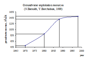
Groundwater exploration was carried out in 1970-1990 and calculated exploitation evaluation (Fig.1).
Groundwater types that carried out hydrogeological exploration are (Batsukh N, 2000):
Groundwater in recent river basin
Groundwater in alluvial fan
Groundwater in ancient river basin
Fissure groundwater and groundwater in fault zone
Groundwater in small artesian basins of geosynclinal zone
Surface water measurements were
done during Bogd khan. River water regime and resource investigation
systemically were carried out since 1930. Now surface water monitoring net
composed of 126 gauging stations is working. A book “Surface water of
90.9 of population of
29000 engineer-designed wells and 17000 simple dug wells were constructed in order to reach objectives on pasture land and running irrigated crop farming during 1930-1990. 64.5% of total pasture land is supplied. The main source of pasture land supply was groundwater resource. Along with the reduction on numbers of water points on the pasture land use is experienced a change, and many wells are destroyed and rural water supply was getting worst.
Due to climate change permanently is occurred droughts, decreased groundwater table, and dried up many springs and simple dug wells. Water registration in 2002 is shown that 1984 springs, 683 rivers and 760 lakes were dried up. Surface water was sparsely.
Agriculture without irrigation had a risk to develop arid area such a Mongolia. 1990s, there constructed irrigation system with 50 thousand hectare area and 40 thousand hectare of crop area had been irrigated.
5.2% of total agricultural area was irrigated land during 1990s but in 1998 the irrigated land decreased until 0.6%. This shows that sustainable agricultural development was getting worst. Industrialization had been activated since end of 1960s and mostly mining industries used a big amount of water with increased waste water of the industries.
The discharge of untreated or inadequately treated waste water into the environment is the basic type of pollution, deteriorating water quality. As the end of 1999, the nation’s sewage treatment facilities were able to handle 39.8 % of all daily sewage generated nationwide. However as only 64.2 % of the country is served by sewage pipes and as treatment facilities are still using old equipment, much sewage discharged directly into rivers or nature. 40% of waste water is treated by mechanic and biological methods and remained sewage discharged directly into river or nature.
There are 120 wastewater treatment plants throughout Mongolia, 35 of themwere normal operating condition and 30 were out of operation and remaing were operating partially. As a result of intensive of urban population with related discharge flows and inadequate treatment plants, the basins of large rivers like Tuul, Yeruu, Orkhon and Khangal, along which have high concentrations of both population and industry pollutions. According to statistics, the total discharge of waste water was 126,4 million cubic meters, of which 42 per cent comes from sewage, 46 per cent from industry, and 12 per cent from rural areas. 65.6 per cent of total wastewater treated and about 43 million cubic meter wastewater discharged into the environment without any treatment, mostly into the surface water sources. Only 32.4 percent of water sources have protective sanitation zones. 70 cities were subject to potential industrial pollution, and at least 47 of these had no realistic prospect of relief from pollution.
The
systematic investigation of the quality of national surface waters was begun in
1946 by the National Hydrometeorological Board in Ulaanbaatar
(recently Agency for Hydrometeorology and Environment Monitoring) and intended
to provide basic data on water quality in
At present, surface water quality monitoring is carried out in laboratories by taking samples. The monitoring network consists of approximately 110 stations, located through the national territory. The main objectives of the monitoring are to gather information about the present state of the rivers or lakes and to control the quality of the surface waters. Particular attention has been paid on the parameters, which to be analyzed and the sampling frequency.
In most of the Gobi region and eastern steppes, groundwater has an extremely high mineral content (fluoride, calcium and magnesium) that negatively impacts the health of the people in these regions. In the urban areas pollution from industrial sources as well as human waste are growing-especially as increasing numbers of are moving to large urban centers.
Wells located in
Water disaster is increased
related to urbanization and reasonable climate change. Dam protected from flood
was constructed in the
The Government policy on ecologically sustainable social and economic conditions is to be implemented through legislative documents, long-term programs, planning of activities, coordination and projects.
Law on Water. The purpose of the law is to regulate the protection, proper use and restoration of water resources. The Law includes general provisions concerning research, monitoring, databanks, water use, and the plenary rights of various institutions involved in water-resource management. There are statements given rights on taking watercourses with ecological importance under local protection, establishment of protected zones for the water sources and sanitary zones for drinking water sources for centralized water supply.
In 2000, the National Water Committee (NWC) was established with the purpose of coordinating and monitoring the National Water Programme’s implementation. The Water Law also recognizes the economic value of water, requires capacity-building in the water sector, focuses on the decentralization of water management, puts forward the need for environmental impact assessments and sets new penalties for violating water legislation. According to the Water law adopted in 1995, administrative authorities of all levels, from Parliament itself down to the local level, are given responsibilities and obligations in respect of water management, which they must exercise and carry out.
The National Water Policy Program 1999 reflects overall related issues on water management activities including water resource, water quality, water uses and protection from deterioration and pollution of the water resources. The Program defined main and priority objectives as implementation of multi-stage activities on preventing from negative impacts on health of population by improving of water supply and quality, creation a economic and legislative environment aimed at improvement of the level of proper use of water resources and wastewater treatment activities.
To renew supply wells; develop economy technology; modify facilities and technology in waste water treatment; create groundwater quality monitoring; to reduce water consumption in industries; determinate and implement national policy on proper use; protection and restoration of water resources; undertake ecological and economic assessment of water resources and develop economic incentives to ensure protection and proper use and water resources; develop water use limits and quality standards; establish a water database and keep water records on water use, prevent water disasters and provide management for activities on mitigating damage of water disasters are necessary to implant in frame policy of sustainable development.
Conclusions
Water scarcity, the gap between
human demand for and the availability of water in the required quantity and
qualities, is the fundamental issue of the water supply in
Many users and communities are dependent on groundwater, the flow and availability of which are inherently more stable than of surface water.
At the present time water
pollution is serious problem in
The quality of water is concerning issue. Every group of users requires water of different quality, and total demand is increasing. There is very important to separate users by group: high quality drinking water must not use for industry and agriculture needs or for this reason there was not unnecessary treatment of water for purposes which do not require it.
Water quality degradation is an
increasingly important issue. Water quality in Central and Northern part of
Sustainable development of
References
[1]
Tsegmid Sh (1969) Physic
geography of
[2]
Tserenjav G (1981) Zonation by
condition of fresh groundwater resources of
[3]
Batsukh N (2005) Objectivities of
hydrogeological investigation of
[4]
Batsukh.N and Borchuluun U (1990)
Brief description of hydrogeological investigation in
[5]
Batsukh N (2000) Resource and
optimal utilization of fresh groundwater of
[6] Myagmarjav B and Davaa G (1999) Surface water of