


Achievements
THE STUDY OF WATER RESOURCES VARIATION OF NORTH CHINA PLAIN*
Fei Yu-hong1,2, Zhang Zhao-ji2, Zhang Feng-e2, Chen Jing-sheng2, Chen Zong-yu2, Wang Zhao2
(1. Hohai Univerty, Nanjing 210098;
2.Institute of Hydrogeology and Environmental Geology, CAGS ,
* Grant Project:The Project Supported by Natural Science Foundation of Hebei Province “Hebei province south-to-north water diversion midline underground potential (SN: 403614); the broad subject matter of National Land and Resource “The foreground for sustainable exploitation and utilize of groundwater in North China” (Project SN: 20023064).
The brief introduction of
author: Fei Yuhong (1960-), female, from Shanghai,
Researcher, in-service doctor of
Abstract: The North China Plain is an important producing area of domestic foodstuff. The underground water resources are main water supply source of this district. Under influence from increasing produced quantity and climate change, water resources restrict its development. With the trends of decreasing precipitation and ascending air temperature in recent years especially, originally tiny water resources weaken the supply resources much more. With analysis of precipitation, evaporation, surface runoff, changes of underground water flow field and series changes of underground water resources, it is thought that the factors such as decreasing precipitation, ascending air temperature, human riparian work and exploitation of underground water etc are important to cause the decrease of the water resources in this district.
Key words: Water Resources; North China Plain; Climate Change; Human Activities
The water for living and plant water of industry and agriculture in the North China Plain adopt mainly underground water. The produced quantity of underground water accounts for about 70% of overall water consumption according to the statistics. Under the influence from a series of factors such as the exploitation of underground water, superterranean hydraulic engineering, precipitation, evaporation etc in recent 50 years, the short of water resources became more and more conspicuous.
1 General Description
1.1 Geographic position
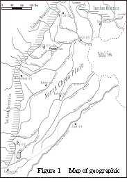
North China Plain lies between east longitude 112°~120° on westward of Bohai Sea, north latitude 35°~43° on northward of Yellow River (Figure 1), including whole of Beijing, Tianjin, Hebei province plain, and the plain in Shandong province and Henan province to the north of Yellow River.
The
1.2 Hydrology characteristic
The North China Plain is dry or semiarid area, where multi-year average precipitation is 556.0mm. The distribution of precipitation in a year is very asymmetric, the 75~85% of which is concentrated between June and September. The continuous high-flow year or continuous low-flow year is the characteristic of precipitation.
The source of surface runoff mainly relies on precipitation. The distribution of high-flow and low-flow, terrain and time has analogy with precipitation code. Multi-year average annual runoff depth is 41.0mm and the runoff coefficient is 0.1.
Since impounding of mountain pass reservoir in recent years, the runoff from mountain land hardly drained into the plain riverway, majority of which became seasonal stream or perennial dry. Annual variation of runoff is bigger than that of precipitation. The coefficient of variation of annual runoff Cv is 0.42~1.10.
1.3 The distributing and recycling characteristic of underground water
The underground water of North China Plain mainly exists in the aquifer system of Quaternary System hole. They are divided into 4 water-bearing formations from top to bottom by their embedding characteristic and waterpower character. The underground water in the 1st aquifer system is called the shallow underground water and the underground water in the 2nd~4th aquifer system is called deep underground water. The commingling of 1st and 2nd aquifer system on piedmont plain has been done. They are called by a joint name as shallow underground water. [1]
The buried depth of shallow underground water on piedmont plain is 120~150m, which is above salt water geologic body on plain to the middle and east. The shallow underground water takes active part in the circulation and alternation between atmospheric precipitation and surface water, the change of which keeps close connection with human activities and climate change. The underground water storage medium on piedmont plain has strong percolation capacity, which is the main infiltration accumulation area of local underground water. The 62% underground water resources are stored in piedmont plain.
2 The Variation Character of Water Resources
There were great changes on the quantity and distributing of North China Plain water resources in recent 50 years. Especially the change of underground water gravitational field and water cycle condition affected the utilization of water resources in this district. The main variation character is showed as following.
2.1 The supply, runoff and drainage condition of underground water
The supplementation of underground water changes as the variation of natural condition and artificial condition. The supply resource of shallow underground water is mainly precipitation infiltration supply. The second resource is piedmont lateral runoff supply and riverway leakage supply. By the influence from factors such as surface water irrigation and underground water irrigation etc, the recharge source of underground water adds canal system leakage supply, irrigation infiltration supply among farms and well irrigation regression supply etc.
The underground water runoff flows from piedmont to the contiguity to the sea in natural condition. By the influence from durative degression of underground water and degression of supply, the characteristic of underground water runoff changes a lot, which alter the direction of runoff in natural condition. The trend interflowing from around to center is formed in the concentration of mining area and the hydraulic slope changes a lot.
The drainage mode of underground water is influenced greatly by its model of occurrence and exploitation condition. In piedmont plain area, with degression of underground water level, increase of aeration zone thickness and the water level buried depth under phreatic evaporation limit, the drainage mode is mainly vertical drainage by man-made recovery and draining to downriver runoff. In the littoral plain, the drainage mode of underground water is mainly phreatic evaporation consumption for the higher mineralization degree of underground water, worse exploitation technique, lower utilizing of underground water exploitation, lower buried depth of underground water elevation.
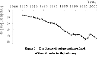
2.2 The sharp drop of underground water level
In the beginning of twentieth sixties, the shallow underground water level in piedmont plain area was between 25~80 m. The underground water gravitational field keeps natural state basically. The shallow underground water level in piedmont plain area declined 5~20m generally till 1984. In 2001 it declined 5~10m.
With the
decline of shallow underground water level,
the uneven underground water coning appeared in the central city areas along
the line of piedmont which exploited underground
water concentratedly, such as Beijing funnel,
the Gaoyang-Lixian-Qiangyuan funnel nearby the Baoding,
Shijiazhuang funnel, Ningjin-Baixiang-Longyao
funnel,
The figure 2 reflects the developing process of
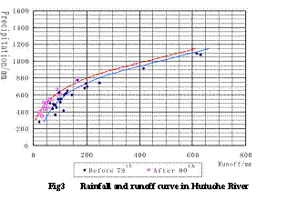
2.3 The decrease of overland runoff generation
It was calculated that the average of surface water resources amount in Haihe River valley was 220×108m3/a between 1956~1998 and that between 1956~1984 was 264×108m3/a, which decreased 16%. It can be concluded from the relation of precipitation and runoff that the runoff volume generated by onesize precipitation decreased by comparing the afterward of twentieth eighties to the previousness (Figure 3). For example, the runoff coefficient in this district was 0.48 when there was flood in 1963, but it was 0.25 when there was flood in 1996. [2]
2.4 The decrease of amount of water into sea
The amount of water into sea is decreased for the reduce of direct runoff rate and increase of runoff consumption. It was calculated that the average amount of water into sea from Haihe River valley was 107×108m3 between 1956~1998, thereinto the data was 241×108, 161×108, 116×108, 26.9×10⁸, 68.5×10⁸m3 in fifties, sixties, seventies, eighties, nineties respectively. Then it can be seen that the data in eighties and in nineties was lower than the average and being decreased continuously.
2.5 The decrease of riverway leakage
The long-term dry of rivers resulted in the obvious decrease of recharging underground water quantity along riverway line in the plain terrain. For example, the multi-year average recharging quantity of underground water in piedmont plain was 66.2×10⁸m3/a between 1956~1980, thereinto the supply from riverway leakage accounting for 7.29%. The stock size that riverway leakage supplied to underground water decreased to less than 3% between 1980~2000.
3 The Physical Factor Analyses of the Change of Water Resources
3.1 Precipitation
From the comparison between the hydrology series between 1956~1998 and those between 1956~1984, the multi-year average precipitation decreased 1.6%.
The most important factor to restrict water cycle is the climatic factor, which has two kinds of influences (direct influence and indirect influence). The former is mainly from the change of precipitation spatiotemporal distribution, intensity and gross aroused by the change of general atmospheric circulation. The indirect influent is mainly from land factor. [3] Compare the climate characteristic (R/P and E/P) of water cycle on land in the Haihe
River valley with that of each valley: it was 0.16
and 0.84 in the Haihe River
valley; 0.18 and 0.82 in
the Yellow River valley; 0.49 and 0.51
in the
Since
twenties fifties, the precipitation of fifties, sixties and seventies was
higher than the multi-year average precipitation of decades in this district.
But that of eighties and nineties was lower than average. The average was 3.2%,
7.1%, 2.0%, -7.2%, -5.3% respectively. For example the precipitation of
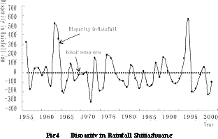
It can be seen from the anomaly change process of precipitation of Shijiazhuang city, the representative of submountain region, between 1956~2002 (Figure 4) that the average precipitation was 531.4mm, in fifties it was 580.6mm which was about 9.4% higher than the average; In sixties it was 581.2mm, which was about 9.4% higher than the average; it was 500.6mm in seventies which was about 5.8% lower than the average; it was 501.1mm in eighties which was about 5.7% lower than average and in nineties was 549.3mm, which was about 3.4% higher than the average.
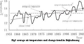
3.2 Air temperature
According to research, there was a trend of rise in multi-year average air temperature of North China Plain. For example, the annual average air temperature of Tianjin city rose 1ºC between 1949~2001. The mean annual temperature of Shijiazhuang city in nineties was higher 1.3ºC than that in fifties.
Figure 5
shows the change process and trend of air temperature in
|
Table 1 Changes of precipitation and evapotranspiration rate in Baiyangdian Plain | ||||
|
Item |
Fifties |
Sixties |
Seventies |
Eighties |
|
1950~1960 |
1960~1970 |
1970~1980 |
1980~1988 | |
|
Precipitation/mm |
648.9 |
595.2 |
534.7 |
515.9 |
|
Evapotranspiration rate/mm |
551.4 |
608.7 |
599.5 |
607.5 |
|
Precipitation-evaporation/mm |
97.5 |
-13.5 |
-64.8 |
-91.6 |
|
Table 2 Reservoir of North China Plain distributing | ||||||
|
River Reservoir |
|
|
|
|
|
Total |
|
Storage capacity/108m3 |
64.86 |
48.56 |
32.74 |
35.17 |
20.26 |
243.03 |
|
Pieces |
6 |
3 |
6 |
5 |
5 |
30 |
3.3 Evaporation
With the compare to the precipitation of corresponding year, the evapotranspiration rate on land has trend of increase in recent 40 years. Table 1 shows changes of precipitation and evapotranspiration rate in Baiyangdian Plain. In fifties the precipitation was more than evapotranspiration rate. After sixties the precipitation became less and less than evapotranspiration rate, which resulted in the increasing of water consumption in valley.
4 The Human Factor Analyses of the Underground Water Change
The influence by human activities to water cycle is mainly on following 2 aspects: One is the productive activity and socioeconomic development which change the chemical constituent of atmosphere to raise air temperature and increase evaporation, the other is that the human activity mainly acts on the underlaying surface of valley, such as exploitation of water resources etc, to change physical parameters such as albedo that the land has to the solar radiation, roughness, and the expands acreage of impermeable layer etc. Although the latter acts on local, the intensity is always very strong.
4.1 The superterranean hydraulic engineering
The engineering of flood defending, flood impounding and flood discharging etc to avoid flood and alleviate the flood disaster is called flood control works. After developing for 50 years, the North China Plain has built more than 1900 pieces of reservoirs for flood preventing, irrigating, water supply, electricity generating, breeding etc. The total reservoir capacity of reservoirs in mountainous area accounts account for 97% of total reservoir capacity of reservoirs (Table 2), which forms flood control works system for valley preliminarily.
|
Table 3 reservoir cut flood runoff of North China Plain in 1988 | |||
|
Reservoir |
Water into reservoir/( m3/s) |
Water out of reservoir/( m3/s) |
Quantity of cut/% |
|
Wangkuai |
2370 |
752 |
68 |
|
West Dayang |
804 |
341 |
58 |
|
Hengshanling |
543 |
135 |
75 |
|
Angezhuang |
544 |
200 |
63 |
The large-scale reservoir impounds large quantity
of flood from mountainous area, which decreases loss against disaster in plain
region. The eight large-scale reservoirs on the south of
4.2 Underground water exploitation
The shallow underground water is exploited easily and has good connectedness with surface drainage system and atmospheric precipitation system. The shallow underground water system is sensitive to human activities and climate change.
According to the statistics, the yield of shallow underground water in the North China Plain was 179.19×10⁸m3/a, the overall supplementation of shallow underground water was 234.89×10⁸m3/a, the overall output was 257.51×10⁸m3/a, difference between supplementation and output was -22.62×10⁸m3/a. It was at an overdraft state in whole. The exploitation degree was 14×104m3/a·km2.
5 The Trend Prediction
The change of
underground water resources has its nature factor and human factor. Generally,
the nature factor is slower and human factor is faster. However, by the
analyses of nature factors such as precipitation and air temperature of
The
change of temperature and evaporation capacity has direct or indirect influence
on change of water resources. According to the research, every elevation in
temperature will result in 12% decrease of
Some research concludes that there is positive correlation between the decrement of underground water resources in Haihe River plain (DQ)and the decrement of annual precipitation, which can be expressed as following correlation formula:
DQ=1.16DP - 3.64 [7]
That is, if we take the whole North China Plain as a whole and the multi-year average underground water resources quantity and precipitation between 1956~1984 as cardinal number, when the decrement of North China Plain average precipitation is 1%, the underground water resources will decrease 4.8%, which is about 12.81×10⁸m3/a. When the precipitation keeps unchanged, by the influence from human activities, the underground water resources will decrease by 3.64%, which is about 9.72×10⁸m3/a.
6 Conclusions
Water resources in the North China Plain become the bottle-neck of economic development for their insufficient. The analyses show that the local climate change under macroscale is an inducement of the change of water resources in the North China Plain. However the human activities with certain scale that will change directly or influence human living environment at some space-time scale is also an important factor to result in changes of water resources. [8]
References
[1] Chen
Wanghe et al.. UNDERGROUND WATER IN
[2] Hydrology and Water Resource Survey Bureau of
[3] Liu Chun-Zhen. The Review of Impact Study of Climate Variability and Chang on the Water Cycle[J]. Hydrology ,2003,23(4):1~7.
[4] Research Team of
[5] The edit committee for Haihe evolution. Haihe
evolution[M]. Beijing:
[6] Zhang Shifa, et al. Analysis of climate change effects on water resource in The Jingjintong area[J]. Advance in Water Sciences, 1996,7(1): 30~35.
[7] Zhang Guanghui, Fei Yuhong, Wang Jinzhe. Evolution characteristics and trend of shallow groundwater recharge in Taihangshan piedmont plain over the last 300 years. Acta Geoscientia Sinica, 2003,24(3):261~266.
[8] Ye Du-zheng, FU Cong-bin, JI Jin-jun, et al. Orderly Human Activities and Subsistence Environment [J]. Advance in Earth Science, 2001, 16(4):453~460.