Golmud-Lhasa Railway Geological Survey
GEOGRAPHY, ENVIRONMENT AND WORKING CONDITIONS ALONG THE GOLMUD-LHASA RAILWAY
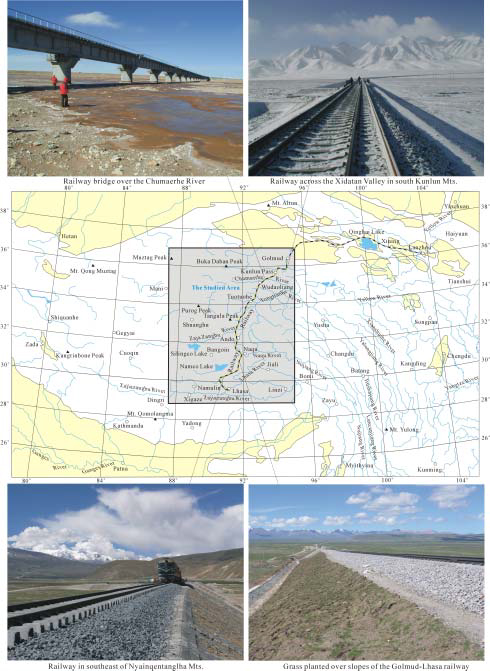
The Tibetan Plateau is the highest and largest plateau in the world and has been described as the “third polar region of the earth” by many people. It is ~2000km long from east to west and ~1000km wide from south to north with a total area larger than 2×10⁶km2. It has an average elevation of 4,500 m. Basins, plateaus and mountains of high elevation are the basic geographic components of the Tibetan Plateau. It forms the water source region for several famous rivers such as the Yangtze River, the Yellow River and the Ganges River (Fig.1). Construction of a railway from Golmud to Lhasa has to overcome difficulties caused by shortage of oxygen, fierce climate conditions and extreme cold winter, permafrost and other geological hazards in Tibetan Plateau along a route as high as 4500-5000m.
The higher part forms a rolling treeless tundra drained by the headwaters of the Yangtse River and crossed by the high glacier-studded Tangula and Kunlun Mountains. The plateau has a climate characterized by severe cold weather and large daily and seasonal temperature changes. The annual average temperature is about 7° to 8°C and the lowest temperature in winter is about −14° to −20°C in the lower, southern part of the Tibetan Plateau. The higher, northern part, north of the Tangula Mountains, has an annual average temperature of −4° to −5°C and an average temperature in winter of −10° to −15°C, with the lowest temperatures in severe winters reaching −30° to −35°C. These conditions have caused a seasonal layer of frozen ground in the southern plateau and permafrost as thick as 100m in the northern part. Most areas of the Tibetan Plateau are windy season in February to April, and a rainy season in June to August. Winds of 20-28m/s always occur in January-April and October-December, and snow falls even in summer in areas as high as 5000m. Field season ranges from May to September each year for geological surveys and engineering construction along the Golmud-Lhasa Railway across the Tibetan Plateau.
Many rivers and lakes are distributed along the Railway (Fig.1). Major rivers along the railway, from north to south, are the Qingshuihe River, Chuma’erhe River, Xiushuihe River, Beiluhe River, Tuotuohe River, Tongtianhe River, Buqu River, Zajia Zangbu River, Naqu and branches and main stream of the Lhasa River (Fig.1). Rivers between Kunlun Mts. and Tangula Mts. belong to the headwaters of the Yangtze River. These include the Chuma’erhe, Qingshuihe, Xiushuihe, Beiluhe, Tuotuohe, Tongtianhe and Buqu Rivers. The Zajia Zangbu River originates in the Tangula Mts., and ends in the Tselingco Lake, thus forming one of interior river systems of the central Tibetan Plateau. Naqu River is the headwater of Nujiang River, and Lhasa River belongs to the headwater of the Yaluzangbu River, which is the upper stream of the famous Ganges River. Lakes along the Golmud-Lhasa Railway include the Qingshui, Chaco, Basico, Cuona, Bengco, Dongco, Pengco, Cuoer and Namco Lakes. The Kusaihu, Zuonai, Hohxil, Wulanwula, Cuorin Dejia and Tselingco Lakes are distributed to the west of the railway. Springs along the Golmud-Lhasa Railway, including hot springs controlled by active faults, and the freezing of springs in winter leads to formation of pingos, freezing expansion of ground surface and potential geological hazards to both the highway and railway.

Fig.1 Geographic position and environment of the Golmud-Lhasa Railway
Driving conditions are very bad away from the Golmud-Lhasa Highway along the very limited side roads connecting towns in the southern Plateau. Landcruisers and trucks commonly become stuck away from the highway and side roads. The population is very sparse in vast areas away from the several towns: Golmud, Nacitai, Xidatan, Wudaoliang, Erdaogou, Tuotuohe and Yanshiping in northern Tibetan Plateau. The population and villages are relatively denser in south Tibetan Plateau especially south of Ando. Several ore deposits have been discovered and some are developed into mines. However, mining activity is not encouraged by the government in order to preserve the delicate ecological environment in the high plateau areas. Famous tourist spots along the Golmud-Lhasa Railway include the Yuzhu Glacial Peak in the southern Kunlun Mts., the Nyainqentanglha Mts., the Namco Lake and the Yangbajain geothermal field, which attracted thousands of tourists each year before the construction of the Golmud-Lhasa Railway.
Field mapping of active faults and geological hazards at scale 1:2000 was deployed in a belt as wide as 1000m along the Golmud-Lhasa Railway, and 1:100000 mapping of active faults was carried out in a corridor as wide as 25km along the railway. The Golmud-Lhasa Railway extends across the Kunlun Mts., Hohxil Mts., Fenghuoshan Mts., Tangula Mts., Nyainqentanglha Mts. via Qingshuihe, Chuma’erhe, Tuotuohe and Tongtianhe plateau, and Wenquan, Ando, Gulu-Sangxiong and Yangbajain-Damxung basins, and finally reaches to Lhasa, capital of Tibet Autonomous Region (Fig.1). The total length of the new Golmud-Lhasa Railway is ~1118km with its north section in Qinghai Province and its south section in Tibet Autonomous Region.


