


Golmud-Lhasa Railway Geological Survey
WEST BOUNDARY FAULT OF GULU-SANGXIONG GRABEN AND FRACTURES FROM THE Ms 7.5 JIUZILA EARTHQUAKE
The west boundary fault of Gulu-Sangxiong graben is ~52km long and extends from Nianbo village in the south, via Jiachigang, Dingmoduo, Barenduo, Gagoqionggo, Guolonkonma and Yanta, to Palima in the north (Fig.11). Faceted bedrock spurs of 200~300m high, high temperature hotsprings, fractures and scarps formed along the fault from several earthquakes during Late Quaternary. West boundary fault generally trends in N10ºE, dips 60±5º eastward and displaces bedrock, glacial deposits, fluvial fans and river terraces vertically. It formed wide fault breccia and has 4-8 branch faults in the eastern piedmont of the northern Nyainqentanglha Mts. Vertical slip-rate and extensional rate of the boundary fault in Late Quaternary are 0.4mm/a and 0.6±0.3mm/a, respectively, and during the Holocene vertical slip-rate is 1~3mm/a with an average rate of 2±1mm/a (Fig.12) (Wu et al., 2005).
The Ms 7.5 Jiuzila earthquake occurred in 1952 along west boundary fault of Gulu-Sangxiong graben, and formed fractures of 68km long from the north boundary of the Damxung basin to the west boundary of the Gulu basin (Wu et al., 1992). Scarps of 3-6 levels formed. Seismic fracture zone can be divided into 5 sections with intensity of X degree occurred in Gulu and Wumatang areas for the Ms 7.5 Jiuzila earthquake in 1952. Several times of Ms 7.5-8.0 earthquake occurred along west boundary fault of Gulu-Sangxiong graben with seismic interval time of 2200~1600a averaging in 1900±300a in Holocene.
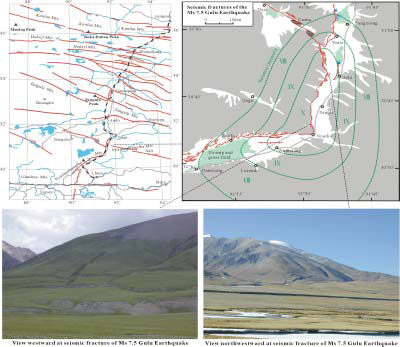
Fig.11West boundary fault of Gulu-Sangxiong Graben and seismic fractures of Ms 7.5 Jiuzila Earthquake
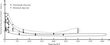
Fig.12 Vertical slip rate of west boundary fault of Wenquan graben