


Golmud-Lhasa Railway Geological Survey
DESTRUCTION OF ENGINEERING FACILITIES CAUSED BY MIGRATING PINGOS
Migrating pingos that form in active faults in permafrost region of the northern Tibetan Plateau were discovered after repeated surveys in summer and winter along the Golmud-Lhasa Railway beginning in 2001. The Budongquan, Chumaerhe and 86th station migrating pingos were caused by active faulting whereas the south Yamarhe, 83rd station and 85th station migrating pingos were induced by the underground construction of bridges within active fault zones (Fig.16). Underground constructions of the DK1202+668 bridge piers lead to formation of the 85th station migrating pingos in winter and clusters of springs in summer during 2002-2003. Migrating pingos are caused by a coupling between active faults, underground water disturbance and temperature change, and result in a serious hazard to engineered construction. Freezing expansion of migrating pingos has destroyed highway bridges, bent an oil pipeline and broke a pier base of a railway bridge. Some engineering measures may help drain the ground-water and prevent winter growth of migrating pingo to reduce their geological hazard.
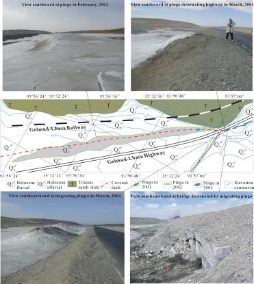
Fig 17 Budongquan Migrating Pingos and their hazards
The Budongquan migrating pingos formed in the covered Budongquan NE-trending fault every winter and thawed to become linear distributed springs in summer (Wu et al., 2004, 2005). The pingos were first noticed when a small pingo with diameter of 1.5m and height of 0.8m appeared in east margin of the Highway in March of 2001, and then changed to clusters of larger pingos distributed in en-echelon pattern along the fault in winter between 2003 and 2004. Partially thawed pingos in March 2004 were 16-20m long, 6-9m wide and 1.2-2.5m high with elongation in the NE direction, parallel to trending of the fault (Fig.17). The coupling between freezing and active faulting also resulted in heterogeneous deformation and a fracture 100m long and 10-25cm wide in the Highway in early 2004. A migrating pingo penetrated the Highway roadbed in early 2001 and destroyed a culvert of the Highway in early 2004, and affecting traffic along the Golmud-Lhasa Highway (Fig.17).
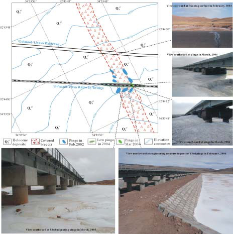
Fig 18 The 83rd Station migrating pingo and engineering measures to its hazard
Some bridge piers were constructed in a fault zone east of the 83rd station of the Highway in the southern of Erdaogou basin (Fig.18). No pingos formed along railway line before the construction of the piers in early 2002. However, the construction of the piers lead to a large volume of spring water during the summer and autumn of 2003, which then resulted in a thick ice sheet and a large high migrating pingo in the winter, i.e. the 83rd station migrating pingo. The ice sheet was as thick as 50cm and migrating pingo as high as 2.5m, reaching across the beam beneath rails in March of 2004 (Fig.18). In the cold winter the top of the pingo must have been higher and seriously threatened the safety of railway. Fortunately, trains running across the railway bridge resulted in pier vibration in the fault zone, which closed the pathways of underground water in breccia, leading to a sharp decrease of spring water beneath the railway bridge to the east of the 83rd station. The design agency constructed a spring water pool to stop spring water flow toward the bridge piers, which evidently reduced the geological hazard of the 83rd station migrating pingo (Fig.18).
The DK1202+668 railway bridge which is 120m long is located in south of the 85th station of the Highway and crosses the north active fault of Wuli basin (Fig.19). On both the east and west sides of the DK1202+668 bridge, springs were distributed in a linear fashion along the fault valley in summer and formed pingos away from the railway line before the construction of bridge in February of 2002. However, the underground construction of the middle pier in fault breccia penetrated a water conduit, leading to spring water rising and surrounding the middle pier. Freezing of such spring water will form a large and high migrating pingo to endanger the safety of the bridge. These data were presented to agency in charge of the Golmu-Lhasa railway design and the agency soon built underground conduits, which drained off the spring water surrounding the middle pier and painted special material on the upper half of the conduits to form a seal for water. These measures effectively stopped upward flow of ground-water and prevented the formation of migrating pingos in the next winter (Fig.19).
In southern Wuli basin, a nearly E-W trending active fault that cuts Late Pleistocene deposits and offsets Holocene stream. It forms a fault valley near the 86th station of Highway, which serves as conduits for surface and underground water flow (Fig.20). The fault valley thaw ponds and low temperature springs appear in summer, and migrating pingos form in winter, termed the 86th station migrating pingos. In March 2001, a pingo formed east of the Wuli 86th station, which is as low as 80cm. In January-February of 2002, the center of the pingos migrated 7m southwestward due to active faulting to 4-8m east of the Highway culvert, and the development of a larger migrating pingo, 15m long, 8m wide and 2-2.5m high, caused a 1.5-2.0m upward bend of the buried oil-pipeline across a 15m long section (Fig.20). In August 2002, the agency in charge of the Golmud-Lhasa oil-pipeline replaced the bent oil-pipeline by a new one and buried it back to its original position beneath ground surface to certain depth. The engineers covered the pipeline with mixture of rock and pebble that are favorable for ground-water flow. This prevented well the accumulation of spring water in summer and the formation of Pingos in winter. This is a successful example of preventing the hazard of migrating pingos for engineered facilities by an underground drainage measures.
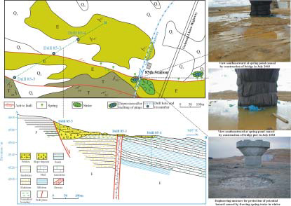
Fig.19 Geological map of active faults (After Hu et al., 1982) and photos of spring caused by underground construction of bridge piers at the 85th highway station
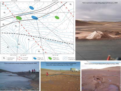
Fig.20 Migrating pingo at 86th highway station and its hazard to engineering facility
During the winter of 2003 to March of 2004, two new pingos formed at the northeast and southwest sides of position of the former migrating pingo in southern Wuli fault valley. The southwestern migrating pingo was large and cone-shaped, 16m in diameter and 1.8-2.0m high, and the northeastern one was smaller, only being 12m in diameter and 0.94m high in March of 2004 (Fig.20). Fortunately, all these migrating pingos occurred far away from the Golmud-Lhasa Railway and did not produce hazards to railway line.